Sandwell Local Plan - Reg 19 Publication
APPENDIX D – Masterplans
(1) West Bromwich Masterplan[1] extract

Carter's Green Development Framework extract

Rolfe Street Masterplan (indicative)
Produced from the Rolfe Street Masterplan 2023 Produced for Sandwell Council by Howells
Rolfe Street Masterplan – Smethwick Regeneration Area
Further details of the regeneration and proposed developments and improvements set out below are identified in the masterplan document, which can be viewed online and which aspiring developers will be required to have regard to when drawing up proposals.
The Smethwick to Birmingham Framework sets out a strategic plan for the whole Smethwick to Birmingham corridor. The Rolfe Street masterplan builds on the framework and sets out in more detail how the area can be developed.
The Smethwick to Birmingham corridor is Birmingham and Sandwell's historic canal district, stretching from The Roundhouse just west of Brindley Place to Galton Bridge in Smethwick. It is the historic link between Birmingham and the Black Country and is one of the most significant areas of brownfield urban renewal in Europe with potential to deliver 4,000 new homes. Transformational change is already underway with new neighbourhoods at Port Loop and Soho Loop, and the Midland Metropolitan University Hospital nearing completion.
Rolfe Street is located at the western end of the Smethwick to Birmingham corridor. It is located adjacent to Smethwick High Street and benefits from a well-connected railway station with a six-minute journey time to Birmingham; the station has seen recent investment including the provision of lift access. It is 15 minutes' walk from the new Midland Metropolitan University Hospital, and one mile from the new Aquatics Centre (delivered as part of the 2022 Commonwealth Games).
The site itself is located largely within the Smethwick Galton Valley Conservation Area, and benefits from several formal and informal heritage assets, which together inform the area's character. The most important of these is the Grade II* listed Engine Arm Aqueduct, which is an important artefact in the history of the development of civil engineering and transportation at the beginning of the 19th century. The retaining wall to the former Corporation Yard is Grade II listed and is an early example of the use of reinforced concrete construction, dating back to the beginning of the 20th century.
There are several other local heritage assets, identified on the Council's Historic Environment Record[2].
Due to the industrial nature of the area, piecemeal development for residential development is not considered suitable, with a more comprehensive approach seen as the most efficient means to deliver a high-quality residential community. Fragmented ownerships make this difficult to provide, hence the need for a strong Masterplan that will guide delivery and support a cohesive development.
|
Analysis |
Outcomes |
Relevant SLP Policies[3] |
|
Strengths |
Very well connected by both public transport and active travel, with regular trains to Birmingham and Wolverhampton, high frequency bus connections to Dudley and Birmingham, accessible Metro links and cycleways including along the canal. Further improvements to cycle routes are planned. |
STR3, STR5, STR6 |
|
Strong heritage significance, including conservation area and nationally and locally listed buildings and structures. |
SHE1 - 4 |
|
|
Successful redevelopment and regeneration projects have already taken place in the vicinity, at Galton Locks and Crocketts Lane, including the conversion of historic buildings to apartments |
SDS3, SHE1 – 4, |
|
|
Challenges |
Rolfe Street and New Street bisect the site, and both are busy and narrow. |
STR1, SID1 |
|
The location of the railway line |
- |
|
|
Site topography - changes in level of about 1–2 storeys in various locations |
SDS5 |
|
|
The existing industrial nature of the site creates an environment unsuitable for a high-quality residential community, as the current activities generate extensive HGV movements and noise pollution. |
SDS5, STR4, STR9, SCO2, SCO3 |
|
|
Informal and fly parking, including across the full width of pavements, making streets feel hostile and inaccessible. |
STR8, Appendix K |
|
|
Alongside the railway line, the busy Tollhouse Way to the south of the site acts as a barrier to pedestrian movement within the existing community and to and from Smethwick High Street - lack of formal crossing points. |
STR5, STR6 |
|
|
The site would benefit from a cycle-friendly crossing between the Rolfe Street and New Street junctions with the A457, ideally located at Cross Street. |
STR5, SID1, |
|
|
Pedestrian links to the canals and into the communities to the north are poor, as there is no access across the aqueduct from the site except via a convoluted route alongside the Engine Peninsula. |
SNE6, STR5, SID1 |
|
|
Opportunities |
Opportunity to open a link through the Enterprise Centre onto the west towpath of the Aqueduct through a former gateway, and to link with the communities and park to the south across Tollhouse Way (given improved crossings). |
SHW4, STR5, SID1 |
|
The canal and heritage assets lending a strong sense of place and a green corridor for recreation. |
SNE6, SHE1 – 4, SHW4, SDS8 |
|
|
The proximity of Smethwick High Street, new segregated cycle routes, and the on-site railway station. |
SDS4, SCE1, SCE2, SCE4, STR5, STR6, SID1 |
|
|
Transformation of Rolfe Street into a lower traffic environment - via street treatment and changes to junctions, or more defined restrictions to create gateway features at either end of Rolfe Street. |
SDS5, STR5, STR6 |
|
|
Opportunity to enhance sustainability and achieve faster delivery at Rolfe Street by using Modern Methods of Construction (MMC). The re-use of existing buildings to reduce embodied carbon. |
SDS2, SHE1 - 4, SCC1 – 4 |
|
|
New public open spaces provided at key nodes, including at the Engine, Engine Peninsula, and alongside the Fire Station and Rolfe House. |
SDS8, SHW4 |
The Rolfe Street masterplan demonstrates how the agreed objectives can be translated into an environment that:
- encourages active travel such as walking and cycling;
- provides access to green space and nature;
- builds on the nationally important history of the site, following the success of recent development at Port Loop and Galton Locks, and the successful Towns Fund bid for enabling works at the Enterprise Centre;
- offers local employment opportunities, improved accessibility and affordable homes;
- addresses issues around climate change and net zero by employing solutions such as consideration of orientation and shading, shared heat pumps and Passivhaus principles.
The masterplan envisages a distinctive, well-designed community being created in this well connected and attractive location.
Heritage Character
A series of heritage character areas have been identified. These have informed the masterplan's character areas analysis and include:
- Historic High Street: a cluster of civic and public service buildings reflecting the former status of Rolfe Street as a high street;
- Eroded High Street: where buildings contributing to the high street character have been lost;
- Industrial Backlands: the area around Buttress Way with detracting character
- Canalside Industrial: area with strong connections to the canal;
- Canals: the historic canal infrastructure, now a green corridor.
These character areas are explored in more detail in the Rolfe Street Heritage Assessment by Donald Insall (December 2022)[4].
This document, and the character areas identified within it, have informed the approach to retention, building form and materiality illustrated in the masterplan.
Character Areas
Four character areas are identified within the masterplan area, which help define distinctive spaces within it. Each has unique characteristics that respond to specific site aspects, to local conditions and to the wider local context. Many of the policies identified above will also apply to these sites and must be considered when detailed schemes are proposed and determined.
Although there is no direct comparison in terms of notional boundaries, reading the historic characterisation work alongside the masterplan provides a useful guide to the appearance and potential of each of the character areas, as indicated in the following table.
Character area
Rolfe Street Heritage Assessment descriptor
Description
Opportunities for improvement
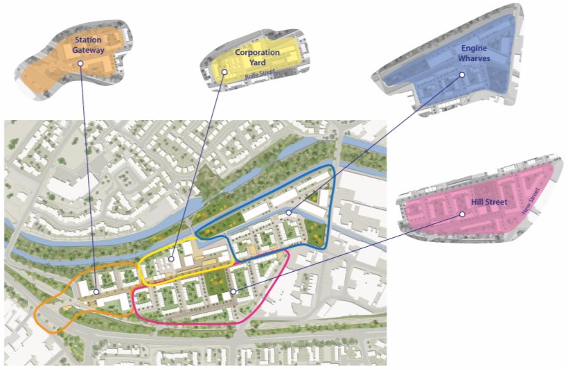
Station Gateway
Eroded High Street
Area is suitable for a higher density development of apartments given its highly accessible location, acting as a gateway for the new community at Rolfe Street. Would support the provision of a new area of public realm (Station Square).
A Mobility Hub could be provided, integrating rail and bus with cycle storage, cycle hire and e-mobility, to provide a 'last mile' solution. Station Square will tie together the Baths Site, Mobility Hub and Rolfe Street, linking to Smethwick High Street through crossing and pavement enhancements. Homes along the canal should be dual aspect, taking advantage of high-level views and providing activation onto a pathway facing the canal.
Corporation Yard
Historic High Street and Canalside Industrial
Enterprise Centre should be transformed into a new community, Corporation Yard. Enabling works have been undertaken, as part of Sandwell's Towns Fund programme. An opportunity for a higher density mix of apartments, duplexes and mews houses. Built form should respect the height, scale and materiality of the retained buildings from the former Corporation Yard, including Block 300 at four storeys, as documented in the Rolfe Street Heritage Assessment. Retention and conversion of historic buildings if feasible.
The existing bricked up gateway onto the western side of the Aqueduct should be restored, providing direct access to the Old and New Main Lines, tying Rolfe Street into the green corridor of the Canal, and linking to existing communities. The opportunities created by the changes in level across the site should be maximised, including potential for undercroft parking and high-level views across the canal, Potential for a new bridge to better connect the engine peninsula. Conversion - potential uses include residential conversion, workspace, business start-up / incubation and maker space.
Engine Wharfs
Canalside Industrial and Canals
A new community located either side of the Engine Arm with a close relationship to the canal. The existing elevations of warehouses along the south side of the canal have high heritage significance. There is potential to retain these elevations within any development, and to maintain the relationship with the water on the south side of the canal in any new development, by using bespoke house types. Historic canal features such as the towpath bridge on the Engine Peninsula should be retained. Rear garden walls should be low, as at Port Loop, to maintain a direct connection to the canal. The Engine Peninsula provides a challenge to development due to a long thin site area. Apartment development is possible and would reflect the historic form. Alternatively, residential development of high-quality townhouses, relating to the canal, would provide much needed family homes.
Canalside Industrial – opportunities noted in the heritage report include: • Open access to the Engine Arm Peninsula via Bridge Street North and from Rolfe Street via Enterprise Centre • Removal of foliage from the canal side of the listed concrete wall and introduce appropriate painted interpretation (subject to using an appropriate medium and carrying out an assessment of the ecological value of the foliage) • Remove some of the less significant 20th century buildings in the Enterprise Centre • The condition of many buildings is poor, so a pragmatic approach is required. Buildings should be categorised in terms of their significance, followed by an assessment of their condition and convertibility on a case-by case basis; a recreation of gabled forms fronting the canal may be the result and if this is so, the reuse of materials should be pursued. Canals – opportunities identified in the heritage report include: • Enhancing the visual appearance of concrete terracing on the north side of the canal (public art, planting) • Exposing the concrete wall (Grade II), with the potential for appropriate artistic interpretation • Introducing connectivity to the canal, potentially via the Enterprise Centre • Engine Arm Aqueduct – modern railings and surfaces could be improved (some original surfaces have been removed) to enhance its setting – and provide connection from Enterprise Centre • Improving landscaping adjacent to Bridge Street North (Pope Bridge / Rolfe Bridge) • Landscaping the existing tarmacked enclave / plant north of the feeder arm
Hill Street
Industrial Backlands
Hill Street should become a high-quality residential community, around central public open space. A townhouse-led approach, as at Port Loop, would provide the density needed to make a community on the site viable and not isolated
Opportunities identified in the heritage report include: • Redeveloping the area, following its historic character, and taking the opportunity to restore a finer grain and historic uses (e.g., residential) • Improve pedestrian / car relationship and restore appropriate hard surfaces. • Improve views in and out of the area. • There may be scope to retain gable ends or walls as part of redevelopment
Grove Lane Masterplan[5] – Smethwick Regeneration Area
Produced from the Smethwick to Birmingham Corridor Framework – Grove Lane Masterplan (2022)
Produced for Sandwell Council by Tibbalds
Grove Lane Masterplan
Further details of the regeneration objectives, proposed developments and improvements set out below are identified in the masterplan document, which can be viewed online and which aspiring developers will be required to have regard to when drawing up proposals.
The Smethwick to Birmingham Framework sets out a strategic plan for the corridor that runs between Smethwick and Birmingham. The Grove Lane masterplan builds on this framework and sets out in more detail how the area surrounding the Midland Metropolitan University Hospital can be developed. The corridor itself is Birmingham and Sandwell's historic canal district, stretching from The Roundhouse to the west of Brindley Place to Galton Bridge in Smethwick. It represents the historic link between Birmingham and the Black Country. The Masterplan area itself is one of the most significant areas of brownfield urban renewal in Europe.
At the heart of this corridor, the Grove Lane area houses the new Midland Metropolitan University Hospital (MMUH). With the surrounding land, it forms one of the most significant intervention sites in Sandwell. A masterplan and a high-level strategic framework have been prepared to guide development across the area and have been approved by the Council.
The Grove Lane area comprises land between Grove Lane to the west, Dudley Road to the south, Moilliett Street Park and Winson Street to the east and the Birmingham Canal to the north. The new hospital is located centrally within this area, abutting Grove Lane. A series of brownfield sites surround the hospital to the north, east and south. It has been awarded Housing Zone status and has the potential to deliver approximately 800 new homes across almost 18ha of brownfield land. Some of these have already been provided, with around 140 dwellings constructed north of Cranford Street.
|
Analysis |
Outcomes |
Relevant SLP Policies[6] |
|
Strengths |
Proximity of the canal; the canal is a potential asset, providing recreational value and historic context. Cape Arm branch; the branch off the Main Line offers additional waterfront potential for development |
SDS5, SDS6, SDS8, SNE6, SHE1 – 4, SHW4, SID2, SDM1 – 3 |
|
Potential for new / improved public realm and spaces around hospital; the scale of the hospital gives it the potential to frame significant public spaces. This could lead to a range of interesting spaces for varied purposes |
SDS3, SDS5, SDS8, SHW4, SDM1 |
|
|
Good connections by road; the nearby road network links well to surrounding places of note, particularly radial routes |
STR1, STR2 |
|
|
Some interesting heritage / older buildings, particularly in Cranford Street |
SHE1 - 4 |
|
|
Proximity to local centres, including Cape Hill and Dudley Road, which offer diverse commercial and retail services |
SCE1 – 6, Cape Hill Profile |
|
|
Challenges |
Poor pedestrian and cycling infrastructure; pavements and roads are often narrow and can be compromised by rat-running and heavy traffic. The non-vehicular network is poorly maintained. |
STR5, STR6 |
|
Poor connections to rail-based public transport. Links to the Metro and traditional rail are difficult, and stations are not within easy walking distance. |
STR3, STR5, STR6 |
|
|
The area is dominated by a traditional industrial built environment |
SDS3, SDS5, SHE1 – 4, SEC1 – 6, SCO3, SDM1 |
|
|
Heavy traffic serving the industrial area |
STR4 |
|
|
Pavement parking |
STR8 |
|
|
Opportunities |
Integrating the area with Dudley Road high street |
SDS3, SDS4, SCE1 – 6, STR5 |
|
Incorporating the Cape Arm canal into the design strategy |
SDS5, SDS6, SDS8, SNE6, SHE1 – 4, SHW4, SID2, SDM1 – 3 |
|
|
Reconnecting Cranford Street / Heath Street with Dudley Road |
SDS3, SDS4, STR5 |
|
|
Replacing a large industrial employment site with a predominantly residential neighbourhood (element of mixed use / education campus / school) |
SDS3, SDS5, SHE1 – 4, SHO1 – 4, SHO9, SHO11, SEC1 – 6, STR3, STR5, STR8 – 10, SID1 – 4, SCO3, SDM1 – 3, SDM9 |
|
|
Addressing the scale of, and provide connectivity to, the new hospital |
SDS5, SHW2, STR5, SDM1, SDM3 |
|
|
Reinforcing the network of mutually supporting uses required to help the neighbourhood function |
SDS3, SID1, SCE5, |
|
|
Overcoming land ownership constraints to enable the creation of a unified and seamless network of streets and spaces with an attractive public realm |
SDS3 |
|
|
Converting some existing buildings to maintain an element of history and add variety to the built fabric |
SDS3, SHE1 – 4, SDM1 |
|
|
Establishing a mix of houses and flats to offer a range of accommodation to existing and new residents |
SDS2, SDS3, SDS5, SHO1, SHO3 - 5, SHO7 - 8, SHO11 |
|
|
Enabling the creation of a green and blue open space network within the neighbourhood, to help meet recreational demands, including improvements to Moilliett Street Park |
SDS8, SNE2, SNE6, SHW4 |
|
|
Distributing scale and density to reflect the changing character of the area |
Vision, SDS1 |
|
|
Locating taller buildings at focal points / gateway sites. |
SDS5, SDM1, SDM3 |
|
Wider Corridor objectives pertinent to the Grove Lane area |
SLP Policies[7] |
|
Housing provision – a mix of good quality housing typologies, tenures and densities that reflect local need, meet design standards, and which can adapt to changing lifestyles and property market considerations. |
SHO1 – 7, SDM2 |
|
Economic regeneration - through construction opportunities and the expansion of healthcare, research, commerce, environmental science and technology and the enabling of start-up and small businesses |
SDS1, SDS3, SEC6 |
|
Active travel and connectivity – prioritise active travel and create '20-minute neighbourhoods' (i.e. the availability of most services or facilities meeting local needs within a 20-minute walk or cycle from home) |
STR5 |
|
Canal network – enhance its recreational and daily commuting role. Create direct and barrier free linkages. Green the canal corridor. Create opportunities for waterside living. |
SDS8, SNE1 - 3, SNE6, STR5 |
|
Place-making - people-centred communities and existing local centres. Enhance the existing characteristics of the area as well as creating a distinct identity informed by the historic environment. |
Vision, SDS5, SDS8, SNE2, SNE6, SHE1 – 4, SCC3, SCC5 – 6, SHW4, SHO1 – 7, SCE1 – 5, STR5, SID1, SDM1 - 10 |
|
Education – meet defined education needs through provision of a new primary school at Grove Lane. Seek a higher education presence linked to the Midland Metropolitan University Hospital. |
SHO9, SID1 |
|
Sustainability – reduce air pollution and help de-carbonise transport. Explore opportunities for renewable energy generation, sustainable construction and a heat network. |
SDS2, SCC1 – 6, SHW3 |
The Grove Lane masterplan demonstrates how the agreed objectives can be translated into an environment that:
- encourages walking and cycling through delivering compact development forms and attractive street environments that prioritise people, such as mews streets;
- provides access to green space and nature;
- provides a variety of different housing typologies, enabling the creation of mixed communities;
- while meeting local standards, allows future flexibility should the anticipated modal shift towards less car usage be achieved.
Potential Heat Network
Sandwell Council is currently exploring the opportunity for a heat network within the Grove Lane area as part of its regeneration. If this is taken forward, Policy SCC1 – Energy Infrastructure – would become even more relevant.
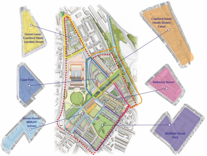
Character Areas
Seven character areas are identified in the masterplan, which each relate to distinctive spaces within it. Each one has unique characteristics that reflect its specific location, local conditions and wider context.
Many of the SLP policies identified above will also apply to these sites and must be considered when detailed schemes are proposed and determined.
|
Character area |
Description |
Opportunities for improvement |
|
Cranford Street / Heath Street / Canal |
This area lies between Cranford Street and the canal in the north of the Grove Lane area. The masterplan envisages the retention of some of the existing buildings on Cranford Street, and the provision of a mix of housing typologies that will establish a frontage to the Canal feeder. |
A new north-south public space to help connect Cranford Street to the northern boundary. |
|
Cape Arm |
This area sits within the boundary formed by the canal branch and Cranford Street. The masterplan envisages a primarily residential development that will sit comfortably alongside the scale and massing of the hospital, perhaps providing a landmark building on the canal basin. |
Public space along the canal front / towpath will help create an area that generates activity within the waterside context. Potential for highway widening to include additional cycleways |
|
The open space network |
These areas provide structure to the Grove Lane area, enabling movement between different spaces and beyond the site into adjoining areas. The spaces are of different scales, character and function, related to their immediate context. |
Additional open space to be provided to enhance the current network. Explore potential for a more direct link to the canal. |
|
Grove Street / Hospital / School |
This area creates a key link between two main community functions required in the area. Grove Street needs to enclose the space and enable access across the character area to Moilliett Street Park and beyond to Dudley Road. Residential blocks should be taller the closer they stand to the hospital. |
A new school on Grove Street. |
|
Moilliett Street Park |
This area lies at the heart of the residential neighbourhood; a reimagined park will be a central feature. The current park is not well used. |
A smaller and more accessible park is proposed, framed by existing and new development. This should enable the space to function more effectively and be a greater asset for residents. |
|
Abberley Street |
This area is central to the residential neighbourhood and forms an important link between the north-south open space and Heath Street. The western end has a relationship with the canal basin and will be an important focal point both there and on the proposed north-south link. |
Opportunities for a higher density development scheme, retention and conversion of historic buildings (subject to a decision on any potential road widening). |
|
Grove Lane / Cranford Street / London Street |
This area is a more isolated triangular parcel of mixed uses, compromised to some extent by the tapering nature of the northern end of the site and its proximity to the roundabout and the road junctions. A mix of housing typologies could be provided throughout the area. |
A prominent site on the main road that can accommodate taller / landmark buildings to act as focal points along the strategic road network and within the corridor. |
Wednesbury Town Centre Masterplan
Further details of the regeneration objectives, proposed developments and improvements set out below are identified in the masterplan document, which can be viewed online and which aspiring developers will be required to have regard to when drawing up proposals.
The Wednesbury Town Centre Masterplan[8] has been designed to provide a framework for the ongoing regeneration and improvement of the main town centre, drawing on the town's significant historic character and exploiting its increasing connectivity, represented by the extension of the West Midlands Metro between Wednesbury and Brierley Hill.
Wednesbury benefits from the wealth of historic and heritage-related development within the town centre, which was subject to a Heritage Action Zone project in partnership with Historic England. It contains a conservation are of significant size (around three hectares) and several listed buildings and other important heritage assets. It is well-connected to both public transport and the wider strategic network and is reasonably walkable. Improvements to walking routes, cycleways and public transport networks are also being considered.
The town has received a significant degree of public funding for various improvements in recent years. The sources have included:
- Investment from Historic England and the Council in the Wednesbury High Street Heritage Action Zone[9] between March 2020 and March 2024 to deliver improvements to the historic town core and Market Place, with a focus on streetscape enhancements and uplift to surrounding historic buildings.
- A Levelling Up Partnership[10] between the Council and the Department for Levelling Up, Housing and Communities to help deliver new homes, tackle crime and antisocial behaviour, improve green spaces and the overall environment of Wednesbury town centre, and expand the Millennium Centre in the town.
- Investment in transport infrastructure in conjunction with Transport for West Midlands, including the Metro extension and related walking and cycling provision.
The masterplan focusses on the town centre and incorporates both the retail centre boundary identified in the draft SLP and some additional areas containing possible development sites. It also reflects the link to the Metro station to the south of the town centre and the library to the north.
|
Analysis |
Outcomes |
Relevant SLP Policies[11] |
|
Strengths |
A largely intact historic townscape, typically of two and three-storey buildings with continuous frontage and distinctive corner buildings, covering a range of eras, architectural styles and materials. A distinctive and historic street pattern and urban grain, including the triangular Market Place, which has been in existence since at least the late medieval period. |
SDS4, SDS5 SHE1 – 4, SDM1, SDM3 |
|
Significant / landmark buildings, including (but not limited to) the Grade II listed market clock tower, John Taylor Duce & Sons building (Talbot House), the Golden Cross public house, the former Gaumont Cinema, Wednesbury Town Hall and Wednesbury Museum and Art Gallery. Wednesbury Library and Memorial Gardens are located directly to the north of the study area. |
SDS4, SDS5, SHE1 – 4 SDM1, SDM3 |
|
|
A large proportion of active ground floors on Union Street, Upper High Street, Lower High Street and Market, including many traditional shopfronts and public houses, maintaining a commercial character. |
SDS4, SCE1 – 6, SDM4 - 9 Wednesbury Town Centre Profile |
|
|
Challenges |
Areas of weak townscape character including poorly designed modern infill buildings. Inferior quality property elevations / boundaries facing High Bullen where the historic urban grain has been disrupted, creating a negative impression of the town for people travelling into or through the centre by car and bus. Examples of dilapidation, vacancy and gap sites that have an adverse impact on visual amenity and foster an appearance of neglect, and access / views to areas of poor-quality townscape. |
SDS3 - 5, SDS8, SHE1 – 4, SDM1 Wednesbury Town Centre Profile |
|
Significant backlog of repair and maintenance issues across the town, with many buildings in a poor state of repair. Various buildings that have been subject to inappropriate modern alterations and shop front signage, detracting from their historic character. |
SDS3 – 5 SHE1 – 4 SDM1, SDM3 - 5 Wednesbury Town Centre Profile |
|
|
High status / prominent vacant buildings such as the Gaumont Cinema negatively impact views into and out of the town and attract anti-social behaviour. |
SDS3 – 5, SDM1, SDM3 |
|
|
Unsatisfactory welcome to the town centre and resulting adverse impact on user perceptions, including a lack of wayfinding. Access is via back lanes, such as Hitchin's Croft, which lead pedestrians through areas of poor-quality public realm and townscape and provide access / views to the rear elevations of properties. Distance to Metro Stop, poor quality of surrounding environment and routes to the town centre. Presence of dual carriageways and their associated substandard environment have an adverse impact on the perception of the town and its accessibility from adjacent areas using active travel methods. |
SDS3, SDS4, SDS6, SEC1 – 6, STR5, |
|
|
Changing retail context including an anticipated continued decline in town centre retail demand. Current limited retail offer and small-scale evening economy. |
SDS6, SCE1 - 6 |
|
|
Lack of green infrastructure and open spaces within the town centre. |
SDS5, SDS8, SNE1 – 3, SHW4, SDM1 Wednesbury Town Centre Profile |
|
|
Opportunities |
Strong sense of community pride. An existing range of successful community events in the town centre that are helping to change local perceptions. |
SDS6, SDS8, SCE2, SCE3 |
|
Existing character, identity and heritage, which can be enhanced and used as an asset. Existing green spaces and green infrastructure close to the town centre, which can be better integrated. |
SDS2, SDS5, SDS8, SNE1 – 3, SHE1 – 4 SHW4, SHW4, SDM1 |
|
|
Numerous potential development sites that can bring new uses to the town centre. Existing residential and employment uses within walking distance of the town centre, which can be better connected to bring more footfall to the area. Existing pedestrian spaces with the potential to enhance them following recent investment in Market Place. |
SDS1, SDS3, SDS4, SHO3, SEC6, SCE3, SCE6, STR5 |
|
|
Generally good accessibility by road, bus and Metro, and potential to improve the quality of and connections to points of arrival by these modes. |
STR1, STR3, STR5, STR6, STR8 |
|
|
The Wednesbury to Tipton Metro Corridor Regeneration Area brings the opportunity to transform existing lower value industrial uses into a wider range of higher value employment and other uses close to the town centre and metro stop. |
SEC5, STR1 |
The Town Centre Masterplan includes five strategies that will help to shape the future of Wednesbury as both a destination and as a built and natural environment. The strategies consider how change will be implemented, based on a short-term time frame of five years and a longer term one of five years and beyond.
|
Strategy |
Approach[12] |
Link to SLP objectives |
|
Development strategy |
This will support the vibrancy of the town centre by densifying and diversifying the types of land-uses present, in part by providing for a variety of housing types, tenures and affordability. This will help to increase footfall throughout the day and evening, support the viability of local businesses, and promote sustainable patterns of movement by increasing accessibility to services and facilities. Good development that reflects local townscape character will enhance the built environment by infilling gap sites, re-using existing and historic buildings, creating a stronger urban presence in relation to existing roads, increasing the visibility of the town centre. |
4, 6, 13, 15 |
|
Movement Strategy |
This will increase the accessibility of the town centre by all modes, with an emphasis on supporting active travel, integrating with surrounding neighbourhoods and encouraging a shift to more sustainable travel modes. This will ensure that the town centre acts as a focal point for the community, and is convenient, welcoming and inclusive on a day-to-day basis for them and first-time and occasional visitors. Improved connections to the metro and bus station will help to make the town centre more accessible within the region, and will promote new development in an accessible, sustainable location. Improving the points of arrival and interchange between modes will simplify journeys. |
10, 16, 18 |
|
Public Realm Strategy |
This will create a series of attractive, vibrant spaces along key streets within the town centre. It will help ensure that the town centre reads as welcoming, safe, comfortable and inclusive for all visitors. The centre will become easier to understand and use, promoting a positive user experience that encourages people to visit the town centre more frequently and stay for longer. Public realm will integrate high quality materials with urban greening, street furniture, lighting, wayfinding, public art and provision for children's play. It will reflect the distinctive character of the town by integrating aspects of the historic environment, incorporating the recently completed Market Place scheme and linking the town centre with surrounding locations including the metro stop and nearby green spaces. |
3, 4, 12, 13 |
|
Greening Strategy |
This will promote the integration of additional urban greening, ensuring that visitors experience an attractive environment with opportunities for greater interaction with nature. The approach will help to improve air quality and water resilience and promote increased biodiversity, as well as reconnecting the centre with a wider green network. The consideration of human health and wellbeing will be promoted using high quality biophilic designs, which incorporate greening and natural solutions into public realm enhancements, including sustainable drainage and the greening of buildings. |
3, 10, 12, 14, |
|
Sustainability Strategy |
This will support Sandwell's wider sustainability strategy, promoting its commitment to reach carbon neutrality borough-wide by 2041, promote equality and inclusivity in access to energy and heating for all, and support other connected aspirations such as the transition from fossil fuels to low-carbon energy in transport, buildings and other areas of influence. This will include the creation of a 'net zero neighbourhood' strategy that identifies key priorities for local sustainability based on engagement with the local community and other key stakeholders. |
1, 3, 12 |
The Wednesbury Masterplan goes on to identify several projects that will help to deliver the proposed regeneration of the town centre. These include site redevelopments / refurbishments / new buildings, enhancements to the local landscape and environment (both natural and built), infrastructure improvements and the delivery of cultural and activity-related opportunities to increase public participation in and enjoyment of the centre.
While the following list provides an abridged description of some of the schemes (full details of these and other schemes can be found in the masterplan), proposals include:
|
Project |
Description |
|
Wayfinding, Heritage & Arts Trails |
Make provision for a co-ordinated wayfinding system that helps visitors on foot and in cars to navigate the town and access the town's assets and facilities and provides a joined-up visual identity for visitor information.
|
|
Leisure & Social Hub |
Create new leisure and social destination(s) at the former Gaumont Cinema, with consideration given to the desire to create an expanded evening economy and a destination for families and other groups that currently don't visit the town centre.
Proposals should reflect the desire to retain the historic frontage and other elements of the former cinema where possible / appropriate. |
|
Wednesbury Net Zero Neighbourhood |
Develop a net zero neighbourhood plan to understand the local area, recognise opportunities that improve sustainability and support a commitment to net zero carbon and identify other considerations relating to the climate emergency and energy resilience / affordability. A net zero neighbourhood is a community where energy requirements are reduced through demand reduction measures, and remaining energy needs are met through decarbonised energy sources. It will also include employing additional measures to create a sustainable place to live. Development of this strategy should be Wednesbury-specific and include full engagement with local communities, businesses and infrastructure providers. When considering the pathway to Net Zero, a whole-system approach should be applied, considering the interactions, feedback and dependencies needed to identify suitable interventions.
|
[3] This list is not closed – other SLP policies will also apply in each case.
[6] Not a closed list – other SLP policies will also apply in each case.
[7] Not a closed list – other SLP policies will also apply in each case.
[8] https://consultationhub.sandwell.gov.uk/regeneration-growth/wednesbury-masterplan-consultation/supporting_documents/Wednesbury%20Town%20Centre%20Masterplan%20DRAFT.pdf
[9] https://regeneratingsandwell.co.uk/sandwell_projects/wednesbury-high-street-heritage-action-zone/
[11] Not a closed list – other SLP policies will also apply in each case.
[12] Abridged – full details can be found in the masterplan.