Sandwell Local Plan - Reg 19 Publication
(5) 11. Transport
Introduction
11.1 The Local Transport Authority for the West Midlands metropolitan area, including Sandwell, is the West Midlands Combined Authority through its transport arm, Transport for West Midlands (TfWM). TfWM has strategic oversight of the whole network including public transport and major highways, other than the national strategic road network (SRN). The region's transport strategy, along with the policies and programmes that support it, is set out in the West Midlands Local Transport Plan (LTP). LTP4[222] - Movement for Growth (2016) is in the process of being replaced by LTP5. The first element, the Core Strategy: Reimagining the West Midlands, has been approved, and subsequent elements are expected to be by the anticipated adoption date of this Local Plan. Where appropriate, Sandwell transport policies reflect the approach being taken through the emerging LTP5.
11.2 The delivery of an improved and integrated transport network both within Sandwell and in links to regional and national networks is fundamental to achieving the Vision and in helping to transform the borough, deliver housing growth and improve economic performance, and thus in achieving SLP Strategic Objective 10. The development of transport networks in the West Midlands is focused on a step change in public transport provision serving and linking centres, improving sustainable transport facilities and services across the area, improving connectivity to national networks and improving the efficiency of strategic highway routes.The improvements needed to deliver the transport strategy are shown on the Transport Improvements Plan (Figure 15).
11.3 To help address the climate change crisis, strategic and local transport policies, plans and programmes must emphasise the delivery of a modernised and sustainable transport network. Specific objectives include reducing pollution and road congestion through improvements to public transport, promoting walking and cycling networks and reducing the need to travel. National policy also focuses on the need for the transport network to support sustainable economic growth.
11.4 Additionally, the West Midlands LTP has a key role to play in reducing carbon emissions and the impact on the natural environment. The Sandwell Local Plan will therefore need to focus on promoting the appropriate design, location and layout of development, increasing investment in infrastructure, improving the quality, equality and accessibility of public transport, supporting walking and cycling, enhancing road safety and reducing the amount of emissions produced by transportation.
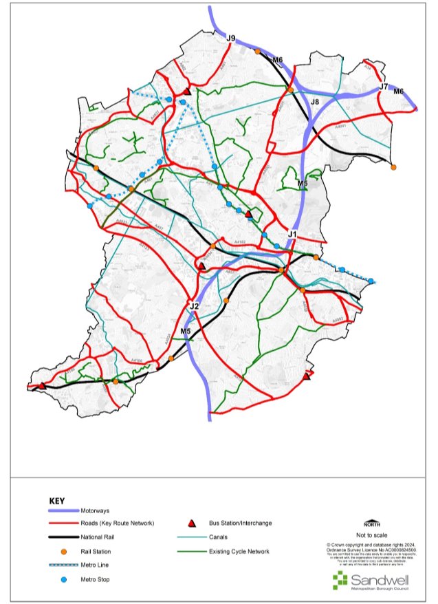
Figure 14 – Existing Transport Network
(3) Priorities for the Development of the Transport Network
11.5 It is acknowledged that the COVID19 pandemic and its aftermath, and the resultant shift towards homeworking has impacted on the way in which transport is used. In particular, there has been a significant impact on public transport patronage levels, which may take many years to recover to pre-pandemic levels.
11.6 However, high-quality public transport combined with the provision of an extensive safe and convenient active travel (walking and cycling) network remains at the heart of the West Midlands transport strategy. The development of the transport network is focused on a step change in public transport provision through serving and linking centres, improving sustainable transport facilities and services across the area, improving connectivity to national networks and improving the efficiency of strategic highway routes.
11.7 Additionally, transport strategy in Sandwell, and the wider West Midlands, has a key role to play in reducing carbon emissions and the impact on the natural environment. The Sandwell Local Plan will therefore need to focus on promoting the appropriate design, location and layout of development, increasing investment in infrastructure, improving the quality, equality and accessibility of public transport, supporting walking and cycling, enhancing road safety and reducing the amount of emissions produced by transportation.
(2) Policy STR1 – Priorities for the Development of the Transport Network
- Land needed for the implementation of priority transport projects will be safeguarded to allow for their future delivery.
- All new developments must provide adequate access for all modes of travel, prioritising walking, cycling and public transport to influence travel choices. Residential development will be expected to meet the accessibility standards set out elsewhere in this Plan.
- Key transport corridors will be prioritised through the delivery of infrastructure to support active travel (walking, cycling), public transport improvements, traffic management (including localised junction improvements) and road safety.
- Key transport priorities identified for delivery during the lifetime of the SLP currently include the following:
- Motorways:
- M5 Improvements (Junctions 1 and 2)
- Rail:
- Midlands Rail Hub
- Rapid Transit:
- Wednesbury – Brierley Hill
- A34 Walsall Road Sprint Corridor
- Walsall – Stourbridge corridor tram-train extensions
- Key road corridors including the following (but not limited to):
- A4123 Corridor Upgrade
- A461 Black Country Corridor
- A457 / B4135 Oldbury, Smethwick to Birmingham Corridor
- A4034 Blackheath and Oldbury Corridor
- West Midlands Core Bus Network corridors
- Interchanges:
- Dudley Port Integrated Transport Hub
Justification
11.8 Good connectivity to the wider regional national transport networks and Birmingham International Airport for both passengers and freight has been identified as being necessary to support the regeneration of Sandwell. The economic growth will be supported by improved access to major global economies.
11.9 Movement for Growth sought to enable all residents being able to access at least three strategic centres within 45 minutes (AM peak). This has been carried forward into LTP5 as the "45 Minute Region" concept that envisages this being achieved through a combination of frequent rapid transit services and high quality "turn up and go" bus services.
11.10 A strategic public transport "spine" comprising high quality, reliable, fast and high-capacity rapid transit between the strategic centres - Brierley Hill, Walsall, West Bromwich, Wolverhampton and Birmingham remains a crucial element of the Black Country's and Sandwell's transport strategy. It is necessary to support the role of these centres as a focus for employment, shopping and leisure, and increasingly housing.
11.11 Currently Metro line 1 provides the required standard of link between Wolverhampton, West Bromwich and Birmingham but it is important that the public transport modes of rail, metro and bus are better integrated to ensure that people can use them to travel where and when they need to. The combination of the Wednesbury to Brierley Hill metro extension and the proposed Dudley Port Integrated Transport Hub have now added Dudley to the rapid transit network which will eventually also include Brierley Hill through the completion of the extension.
11.12 The Black Country Rapid Transit study of 2016 concluded that full delivery of the Public Transport Spine would best be achieved by completing the Stourbridge to Walsall corridor as a tram-based facility (subject to the adoption of Tram-Train technology) whilst the Walsall to Birmingham link should be catered for through bus rapid transit. This is the A34 SPRINT project, Phase 2 of which is currently being delivered.
11.13 The completion of feasibility studies into the provision of the Stourbridge to Brierley Hill and Wednesbury to Walsall rapid transit proposals will be an early requirement for taking the strategy forward, with the latter providing improved connectivity for residents in Tipton and Wednesbury in particular.
11.14 It is vital that new development has access to high quality public transport facilities and services from the outset as this will ensure that people travelling to and from these areas do not establish unsustainable travel patterns due to the initial absence of good public transport.
11.15 The Sandwell Local Plan supports the delivery of an enhanced transport network for the borough, to ensure a seamless integration of land-use and transport planning and to demonstrate the strong interdependency of future land-use decisions and adequate servicing by a variety of travel modes. The exact mode of public transport should reflect existing demand and take account of potential future economic or housing growth points to ensure an integrated approach to sustainable development and travel patterns. This is essential to support the scale of growth proposed for the core regeneration areas and strategic centres and to create an effective transportation system to support sustainable communities. This transport network will provide communities with access to employment, leisure, education and health care and will facilitate improved access to employment sites.
11.16 In this regard the re-opening of rail corridors such as Walsall to Aldridge, the delivery of an upgraded Wolverhampton to Shrewsbury line and the Midland Rail Hub (developed through Midlands Connect) will support housing growth both within Sandwell and in those areas meeting housing and employment need beyond the borough's boundaries.
11.17 The operation of the highway network needs to be improved to support the growth and long-term viability of Sandwell's economy whilst limiting the environmental effect of transport usage. The emerging LTP5 sets out a strategy to help achieve the West Midlands target for net zero carbon emissions by 2041 by making the best use of the existing highway network in a coordinated way through a programme of Key Route Network (KRN) corridor-based multi-modal improvements.
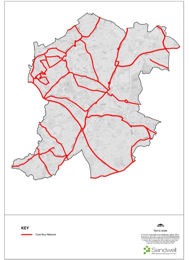
11.18 New highway building within Sandwell will be mainly in support of regeneration, but some key junctions on the DfT's Major Road Network and the West Midlands Key Route Network such as important links for public transport and to the motorway network for freight will be improved by major construction schemes. Highway improvements, especially those located on the West Midlands Metropolitan Cycle Network or the Core Bus Network (see Figure 16), will be expected to address the needs of all users, especially pedestrians and cyclists, and to cater for bus priority in line with current Government guidance.
11.19 The Council will investigate road space reallocation to facilitate public transport and active travel wherever physical constraints permit it. However, due regard will be given to the Council's obligations as Local Traffic Authority under the Network Management Duty contained in the Traffic Management Act 2004.
11.20 Strategic Employment Areas are defined in terms of good access standards to the motorway network. As no new motorways are planned within the lifetime of this plan the M6, M5 and M54 motorways will remain vital transport links for Sandwell business and freight.
11.21 Buses will continue to dominate local public transport provision in Sandwell throughout the plan period. 85% of all passenger miles were catered for by bus prior to the COVID19 pandemic and bus services have recovered at a faster rate than either rail or metro. The National Bus Strategy (2021) requires bus priority to be an integral part of all highway improvements. Therefore, work on the key corridors identified in the West Midlands Bus Service Improvement Plan (BSIP) will play a significant role in delivering this requirement, through a partnership of TfWM, Local Highway Authorities and operators. Specific local measures to help buses will be delivered in other locations where appropriate, along with the upgrading of bus stations in strategic and other centres where demand resulting from the concentration of new developments requires it. Coaches also have a role to play in providing affordable long-distance connectivity and access facilities to and from major Black Country destinations and will be encouraged.
11.22 While improvement of accessibility to bus services will be a priority, some people will have little choice but to make the first part of their journey by car. The success of Park and Ride in contributing to a sustainable travel pattern will depend on minimising the distance driven before transferring to public transport. Well-located Park and Ride facilities can provide a realistic alternative for many car drivers; they can contribute to environmental improvement by reducing congestion on radial routes into centres at peak times and by improving public transport patronage. However, new Park and Ride sites will only be developed in accordance with the adopted West Midlands Park & Ride strategy.
11.23 As transport projects reach the design stage, there will be a need to safeguard land needed for the implementation of those schemes. Where projects are sufficiently advanced, improvement lines will be imposed and land will be safeguarded through the SLP and the Policies Map.
11.24 During the development of new transport schemes, the Council and its partners will exercise due diligence in preventing harm to the historic environment. Where appropriate, due to the size or nature of the scheme, an historic impact assessment will be undertaken.
11.25 Appendix L provides further details on the proposals that make up the transport priorities set out above. The main interventions are also identified on Figure 15 – Transport Improvements Plan.
Figure 15 - Transport Improvements Plan
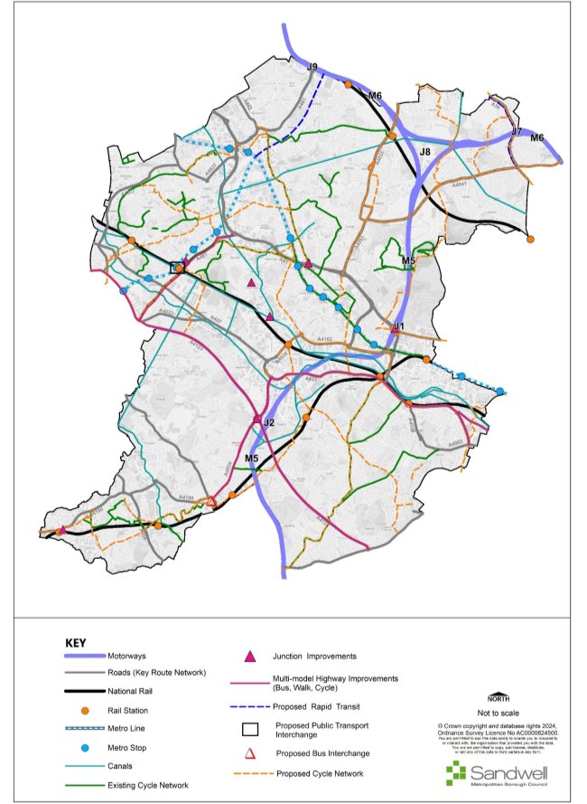
Figure 16 - Core Bus Network Plan
Safeguarding the Development of the Key Route Network (KRN)
11.26 The West Midlands Key Route Network (KRN) caters for the main strategic demand flows of people and freight across the metropolitan area whilst providing connections to the national strategic road network (SRN). Highway capacity will be used to effectively cater for movement by rapid transit and core bus routes, the Metropolitan Cycle Network, lorries, vans and private cars. This will involve the reallocation of road space where appropriate to provide reliable, high volume public transport and segregated active travel provision. There will be an enhanced role for traffic management using new technology via the West Midlands Regional Transport Coordination Centre (RTCC).
(1) Policy STR2 – Safeguarding the Development of the Key Route Network (KRN)
- Sandwell will, in conjunction with Transport for West Midlands and other neighbouring local highway authorities, identify capital improvements and management strategies to ensure the KRN meets its strategic functions.
- Land needed for the implementation of improvements to the KRN will be safeguarded to assist in their future delivery.
- Where new development is expected to result in adverse impacts on the KRN, appropriate mitigation measures will need to be identified through transport assessments and provided through planning obligations.
- When working with neighbouring authorities, sub-national transport bodies, infrastructure providers and statutory bodies, there will be a focus on reducing the impact of private car use on the KRN and delivering a net-zero transport system.
Justification
11.27 The West Midlands Key Route Network not only serves the main strategic demand flows of people and freight across the metropolitan area and provides connections to the national strategic road network. It also serves large local flows that use main roads and will need to provide good access for businesses reliant on road-based transport. The network will use highway capacity effectively to cater for movement by rapid transit and core bus routes (the West Midlands Core Bus Network as shown on Figure 14), the Metropolitan Cycle Network, lorries, vans and private cars. This will involve the reallocation of road space where appropriate to provide reliable, high volume public transport and enhanced cycling facilities. However, the Council's duties under the Traffic Management Act 2004 will be taken into consideration when developing proposals.
11.28 The Key Route Network has been defined on the basis of a West Midlands Combined Authority definition agreed with the seven highway authorities, in consultation with neighbouring highway authorities. The KRN features agreed performance specifications drawn up for different types of links in the network in accordance with their role for movement ("link"), and their role as a destination in its own right e.g., a suburban / town centre high street ("place").
11.29 Improvements will be implemented to meet the agreed performance specification for the links and junctions involved to support road based rapid transit proposals such as SPRINT (Bus Rapid Transit) and Metro. Improvements will take into account guidance contained in the National Bus Strategy and the West Midlands Vision for Bus. Where routes also form part of the Metropolitan Cycle Network, the standards contained in Local Transport Note 1/20 will be applied.
11.30 Capital scheme improvements will be identified where appropriate, but it also is vital that this network is managed efficiently through the collaboration of all four Black Country authorities and Birmingham City Council in their role as Local Highway Authorities, along with National Highways.
Managing Transport Impacts of New Development
11.31 To ensure that the transport elements of the Sandwell Local Plan are deliverable, it is essential that both new developments and existing facilities identify travel and transportation impacts and proposals for mitigation. It is important that accessibility by a choice of sustainable modes of transport is maximised. Transport Assessments and Travel Plans produced by developers, employers, schools and facility operators are essential to bring about sustainable travel solutions and help deliver Strategic Objectives 2 and 16.
(1) Policy STR3 – Managing Transport Impacts of New Development
- Planning permission will not be granted for any proposals that are likely to have significant transport implications, unless accompanied by mitigation schemes that demonstrate an acceptable level of accessibility and safety can be achieved using all modes of transport to, from and through the development. Mitigation schemes must in particular address access by walking, cycling, public transport and shared transport, for example by facilitating car clubs.
- These proposals should be in accordance with an agreed Transport Assessment, where deemed necessary by the Local Highway Authority, and include the implementation of measures to promote and improve such sustainable transport infrastructure and facilities through agreed Travel Plans and similar measures.
- Sustainable transport modes must be made more convenient than car usage for the majority of journeys in order to promote genuine modal shift. They should be supported by the necessary management and regulatory measures if deemed necessary by the Local Highway Authority. Planning conditions and /or legal agreements may be required to ensure the implementation of agreed measures.
Justification
11.32 All developments will be assessed both in terms of their impact on the transport network and the opportunities that could be available to ensure that the site is accessible by sustainable modes of transport. The supporting documentation will either take the form of a full Transport Assessment (TA) or a less detailed Transport Statement (TS) and will generally be determined by the size and scale of development or land use. This will be based on guidance from individual authorities with a TA sometimes being required instead of a TS based on reasons other than spatial thresholds; road safety concerns, existing congestion problems, air quality problems, concerns over community severance or likelihood of off-site parking being generated.
11.33 TfWM's guide for developers should be routinely consulted for larger developments.
11.34 Where a development is considered to have a potential significant effect on the Strategic Road Network (SRN), National Highways will be consulted. In addition, National Highways should be consulted on developments considered to have a significant impact on the Strategic Road Network Designated Routes for Unplanned Events (DRUE). The SRN and DRUE are shown on Figure 15.
The Efficient Movement of Freight and Logistics
11.35 New freight railways and rail sidings will present an economic opportunity for Sandwell's businesses. Improved journey times on the Key Route Network will support economic prosperity and switching traffic to rail or inland waterways will relieve the highway network of traffic, thereby reducing congestion, improving air quality and the environment and reducing carbon emissions. The siting of key employment proposals will be steered towards locations with good access to the KRN to assist with reducing environmental impact, improve air quality and reduce carbon emissions. Improvements to the freight network are fundamental to achieving the Vision for sustainable communities, environmental transformation and economic prosperity and to delivering Strategic Objectives 2, 8 and 16.
(2) Policy STR4 – The Efficient Movement of Freight and Logistics
- The movement of freight by sustainable modes of transport such as rail and waterways will be encouraged. Road-based freight will be encouraged to use the Key Route Network whenever practicable.
- The use of low emission vehicles, e-cargo bikes and other micro-mobility solutions will be encouraged, especially for 'last-mile' journeys.
- Junction improvements and routeing strategies will be focussed on those parts of the highway network evidenced as being of particular importance for freight access to employment sites and the motorway network.
- Proposals that generate significant freight movements will be directed to sites with satisfactory access to the Key Route Network.
- Existing and disused railway lines will be safeguarded for rail-related uses.
- Sites with existing and potential access to the rail network for freight will be safeguarded for rail-related uses.
- Depots and train stabling facilities will be safeguarded.
- Consideration will be given to the movement of freight, goods and other courier services on Sandwell's roads when determining location of new development.
Justification
11.36 The level of motor traffic on Sandwell's roads has increased, partly driven by the growing number of trucks, vans, mopeds, and bikes delivering groceries, parcels, and food takeaway services to online shoppers' homes. There is a need to reduce the strain placed by e-commerce deliveries on Sandwell's roads by, for example, identifying sites for parcel lockers, incentivise more "Click and Collect" options to reduce the volume of home delivery vehicles on the roads, catering for the use of e-cargo bikes, low emission vehicles and the use of micromobility to transport goods.
11.37 Within the wider Black Country, freight traffic has always been particularly important, reflecting the area's past level of manufacturing, and it remains significant today with industry, distribution and logistics giving rise to much freight traffic. This is reflected in both the M5 and M6 motorways, where the proportion of heavy goods vehicles can be 30% of total traffic, and the local road network where the traffic on many main routes has an exceptionally high percentage of heavy goods vehicles.
11.38 Heavy Goods Vehicles account for 21% of all transport emissions, with Light Duty Vehicles accounting for 13%, meaning the road freight sector contributes 34% of transport emissions, despite freight representing just 19% of all vehicle miles undertaken in the UK. Making the most efficient use of the highway network whilst providing facilities to transfer freight from road to rail and inland waterways will play a major part in achieving the region's climate change targets.
11.39 The design and layout of much of the KRN in Sandwell dates from a period when goods vehicles were significantly smaller and lighter than those currently in use and this gives rise to problems of reliability and with deliveries and servicing. In many cases upgrading of these routes is neither economically viable nor environmentally desirable.
11.40 Sandwell is a member of the West Midlands Freight Quality Partnership, as are freight operators and their national representative bodies. The Regional Freight Strategy sets a context for planning for freight within the Black Country sub-region. Removal of freight from the road to rail or canal will reduce congestion, and support investment in rail and canals.
11.41 The railway network serving Sandwell and the wider Black Country suffers from capacity problems during the day when there is high demand for passenger services, and this has shifted much freight traffic to night-time operation. Of the disused lines the most important is Stourbridge-Walsall-Lichfield, which has been identified in the Regional Freight Strategy as being an important link for freight moving between the southwest and northeast regions. Locally, four sites have been identified as being suitable for rail connection if rail freight services are reinstated. Within the West Midlands conurbation, the Stourbridge to Lichfield link would act as a bypass for the rail network around Birmingham which has severe capacity constraints. The capacity released by the reopening of Stourbridge-Walsall-Lichfield, as well as benefiting the freight network, would allow extra passenger services to operate to and through Birmingham to the benefit of the wider West Midlands.
11.42 The Regional Freight Strategy notes a shortage of private sidings in the West Midlands region. Sites with existing or potential rail access along current and proposed freight routes, particularly Stourbridge - Walsall - Lichfield, will be protected for rail-related uses.
11.43 The Freight Strategy notes the need to address the increased importance of 'last mile' logistics and the role that transport innovation can play in this; e.g., through provision of parcel hubs, EV charging for delivery vehicles, etc. Where appropriate, locations for infrastructure to facilitate this will be identified through site allocations and in the SLP Infrastructure Delivery Plan.
(2) Cycling and Walking Networks
11.44 The development of sustainable modes of travel and encouraging people out of their cars, particularly for shorter and commuter journeys, is an important element of Strategic Objectives 1, 2, 8, 9, 10, 11, 16 and 18. Places need to be well-connected with attractive, convenient, direct and safe routes available to non-car users, thus providing real choice.
11.45 The cycle network in the West Midlands consists of three tiers:
- The National Cycle Network (NCN) – identified and developed by Sustrans in partnership with local authorities and shown on the Transport Key Diagram. This network provides long distance routes across the country linking major destinations. NCN Routes 5 (Reading to Holyhead via Birmingham) and 81 (Birmingham to Aberystwyth via Wolverhampton and Telford) both pass through Sandwell.
- The Metropolitan Network (known as the Starley Network) – identified by WMCA in the Local Transport Plan and developed through the West Midlands Cycling & Walking Infrastructure Plan (WM LCWIP). These routes link strategic locations in the West Midlands and are also shown on the Transport Improvements Plan (Figure 15).
- Local Networks – these are identified through individual authorities' LCWIPs and are identified on the Transport Improvements Plan (Figure 15).
11.46 The emerging Black Country Cycling Strategy will provide greater detail on those sections of the Starley network and the most important links in the local network.
(2) Policy STR5 – Creating Coherent Networks for Cycling and Walking
- By working in partnership with Transport for West Midlands and neighbouring local authorities, Sandwell will ensure that it can create and maintain a comprehensive cycle network based on the four tiers of the West Midlands cycle network, including the use of common cycle infrastructure design standards such as LTN1/20 and Manual for Streets 2 or such future relevant guidance as may be appropriate.
- Creating an environment that encourages active travel requires new developments to link to existing walking and cycling networks. The links should be coherent, safe, direct, comfortable, attractive, and not impeded by other infrastructure including that provided for other forms of transport and digital / communication infrastructure.
- Where possible, existing links including the canal network should be enhanced and the networks extended to serve new developments.
- New developments should have good walking and cycling links to public transport nodes and interchanges.
- Where possible, a compact and legible urban realm with easy to reach destinations on foot and by cycle should be delivered, including appropriate signage and wayfinding.
- Cycle parking facilities should be provided at all new developments and should be in convenient locations with good natural surveillance, e.g., near to main front entrances for short stay visitors or under shelter for long stay visitors.
- The number of cycle parking spaces required in new developments and in public realm schemes should be determined using the guidance and standards set out in Appendix K.
- Sandwell Council will work with Transport for West Midlands and neighbouring local authorities on expanding the West Midlands Cycle Hire scheme and location and provision of cycle hire infrastructure will be integral when determining new development.
- The design of cycle infrastructure should be in accordance with the principles and standards contained in the Department for Transport's Local Transport Note 1/20 (LTN1/20): Cycle Infrastructure Design.
- Where feasible, to improve the local environment for pedestrians and cyclists, measures to manage traffic should be considered, which may include measures such as modal filters, reducing traffic speeds, road space reallocation, and implementing parking management policies.
Justification
11.47 It is essential that the development of walking and cycling facilities are an integral part of the transport system both on the highway network, canal corridors, Public Rights of Way and on other paths. Comprehensive cycle and walking networks within Sandwell will enable communities to access employment, public transport interchanges, services and facilities in a sustainable way.
11.48 A transport network that facilitates car use and disadvantages walking and cycling can adversely affect the health and well-being of its communities. Identifying and overcoming barriers to walking and cycling during development processes will encourage a renaissance of walking and cycling within the borough and help improve the health and well-being of local communities by reducing the incidence of obesity, coronary heart disease, strokes and diabetes.
11.49 Both walking and cycling are active modes of travel with clear health benefits. The implementation recognises the specific requirements of each with dedicated, segregated cycling provision being the default objective along with a comprehensive network of walking opportunities available both on highway and off road.
11.50 Walking and cycling strategies are incorporated within the West Midlands Local Transport Plan. Their over-arching framework is the West Midlands Local Cycling & Walking Infrastructure Plan. The four Black Country local authorities are jointly preparing a Cycling Strategy for the sub-region, and each will develop their own local cycling and walking infrastructure plans during the lifetime of the SLP.
11.51 All new cycle facilities will be designed in accordance with guidance set out in Local Transport Note 1/20 and TfWM's Cycle Design Guidance.
Influencing the Demand for Travel and Travel Choices
11.52 The management of the demand for road space and car parking, together with influencing travel choices, is fundamental to achieving the Vision for sustainable communities, environmental transformation and economic prosperity and to delivering Spatial Objectives 1, 2, 8, 16 and 18.
(1) Policy STR6 – Influencing the Demand for Travel and Travel Choices
- Sandwell is committed to considering all aspects of traffic management in the centres and wider area in accordance with the Traffic Management Act 2004. The priorities for traffic management in Sandwell are:
- identifying appropriate strategic park and ride sites on current public transport routes to ease traffic flows into centres;
- working together with the rest of the region to manage region-wide traffic flows through the West Midlands Regional Traffic Control Centre and further joint working;
- implementing demand management measures to restrain car usage and managing car parking demand, thereby encouraging behaviour change and increasing travel by sustainable modes of transport;
- providing better accessibility to shared transport services such as demand responsive transport services, mobility hubs and 'car clubs', reducing the need to travel long distances by car or helping people to travel by more sustainable modes of transport;
- providing better transport planning advice and information in partnership with TfWM's Behaviour Change Hub;
- maximising access to high-speed broadband / digital infrastructure will be required to enable smarter working for those that are able to do so, thus further reducing the need to travel.
Justification
11.53 The SLP Spatial Strategy aims to make the network of town and city centres as attractive and accessible as possible, to encourage use of the most sustainable modes of travel.
11.54 An important aspect of demand management is the prioritisation and allocation of road space. Using schemes such as traffic calming measures and full or time limited pedestrianisation will help in encouraging sustainable methods of travel such as walking, cycling and buses, by making these modes more attractive to people visiting the centres.
11.55 Other important elements include the promotion and marketing of sustainable transport through travel plans (Policy STR3), planning conditions / obligations and other associated sustainable mobility initiatives, including the promotion of schemes and opportunities for walking, cycling, micro-mobility (such as e-scooters), public transport and car sharing. These policies will reduce road traffic congestion and pollution, improve road safety, promote social inclusion and accessibility, therefore encouraging consumers to access the four strategic centres using sustainable transport.
11.56 It is recognised that there will always be instances where the use of a car is necessary. However, this can still be achieved without the need to own a car. Where appropriate, the introduction of car clubs, which provide access to vehicles on an 'as-and-when required' basis, will be encouraged.
Network Management
11.57 Sandwell Council is committed to making the best use of its budgets and advocates an asset management approach for the maintenance of its highway network, to help deliver the best long-term outcomes for local communities.
Policy STR7 – Network Management
- Depending on the location of new development, the deployment of advanced and smart technologies that allow the public to plan their journeys more effectively may be appropriate; for example, by providing real time travel information and satellite navigation systems, Variable Message Signs (VMS) along congested parts of the network and digital sensors / cameras to monitor traffic and collect data on traffic patterns for future planning.
- All new developments that impact the existing highway network, or which result in a new asset to be adopted by the Local Highway Authority, may be subject to fees and obligations for the maintenance of the highway network as part of a relevant legal agreement
Justification
11.58 Much of the highway network in Sandwell is constrained by its urban fabric, resulting in narrow roads and footways. In many cases the overall highway width is such that there is limited scope to accommodate infrastructure dedicated to specific modes or groups of vehicles. Therefore, the use of advanced technology to help manage the use of road space will be vital to ensuring that maximum benefit can be derived from the asset.
11.59 However, where development includes the provision of new infrastructure, including dedicated infrastructure for cyclists, buses etc., there will be a need to provide for its ongoing maintenance to mitigate the impact on future highway authority budgets.
Parking Management
11.60 The management of car parking is fundamental to achieving the Vision for sustainable communities, environmental transformation and economic prosperity. It also has a key role in reducing the impact of vehicle trips on air quality and carbon emissions.
(1) Policy STR8 – Parking Management
- The priorities for traffic management in Sandwell include the sustainable delivery and management of parking in centres and beyond, through use of some or all the following measures as appropriate:
- The management and control of parking - ensuring that it is not used as a tool for competition between centres;
- The type of parking – ensuring that where appropriate long-stay parking is removed from town centres, to support parking for leisure and retail customers and to encourage commuters to use more sustainable means and reduce peak hour traffic flows;
- Maximum parking standards – ensuring that a consistent approach to maximum parking standards is enforced in new developments as set out in the guidance and standards contained at Appendix K;
- The location of parking – by reviewing the location of town centre car parks through the "Network Management Duty", to ensure that the flow of traffic around town centres is as efficient as possible;
- Providing more convenient, secure and accessible cycle parking will be a critical part of increasing cycling in Sandwell and making it a natural first choice for journeys. Considering different users and types of cycle parking will be an essential part of this and new developments should consider this in accordance with guidance set out in Appendix K.
Justification
11.61 The correct balance needs to be found between managing and pricing of parking to maximise the use of sustainable travel means to enter town and city centres, whilst avoiding restricting parking to the extent that consumers are dissuaded from using town centres and deterring new development.
11.62 The control and management of parking in centres will require a variety of approaches, recognising that not all publicly available car parking is in local authority control or management. The use of planning conditions to ensure that new public parking is managed appropriately will therefore be an important aspect of this policy.
11.63 The continued adoption of maximum parking standards for all but residential development is an important tool in managing demand for single-occupancy vehicle trips to centres and major employment destinations, leisure and other facilities.
11.64 Reduced levels of long-stay car parking in centres will enable more efficient use of land.
11.65 Where new development that includes parking controls and management to encourage alternative modes for staff and visitors has the potential to impact on adjacent residential areas, post-occupation monitoring may indicate a need for the introduction of residents parking schemes and other traffic management measures. Agreements to secure this will be sought as part of the Development Management process.
11.66 Additional parking enforcement may be required because of new development. Should this require additional resources and thus increase the cost of enforcement for the Council, the developer may be required to contribute to the increased cost of undertaking parking enforcement activities as part of any planning obligations agreement.
Planning for Low Emission Vehicles
11.67 The UK government plans to ban the sale of petrol and diesel cars by 2035, having previously committed to do so by 2030. The resultant societal shift from petrol and diesel internal combustion engine (ICE) vehicles to ULEVs will require widespread support from local authorities as well as the provision of infrastructure by the private sector. It is projected that there will an addition 42,500 ULEVs within the Black Country by 2025. The Black Country ULEV strategy sets out a framework for how the authorities can support this transition.
(1) Policy STR9 – Planning for Low Emission Vehicles
- Proposals for low emission vehicles will be supported by:
- Ensuring that new developments include provision for charging infrastructure in accordance with current legislative and regulatory guidelines;
- Measures to encourage LEV use through travel plans and other initiatives;
- Where appropriate the Council will facilitate the introduction of charging points in public locations;
- Working with partners to explore support for alternative low emission vehicle technologies, such hydrogen fuel cells, across a range of modes; private cars, buses and / or small passenger and fleet vehicles.
Justification
11.68 In July 2019, the West Midlands Combined Authority committed to setting a 'net zero' emissions target by 2041, with a climate action plan being approved by the WMCA board in January 2020. The WMCA Board further approved a regional ULEV strategy in February 2020. The Black Country ULEV strategy sits under this regional document. Whilst the WMCA ULEV Strategy focusses on sharing best practice, co-ordination and possible joint delivery of a large-scale network of rapid charging 'hubs', the Black Country ULEV strategy takes a more granular approach, focussing on the specifics of each authority and offering a framework for the delivery on infrastructure on the ground.
11.69 The study found that the Black Country lags behind the rest of the country when it comes to adoption of ULEVs. This is reflected in the availability of charging infrastructure across the four authorities, with around 80% of the sub-region further than one km from the nearest publicly available charge point. However, relative to median wage, Sandwell sits on or above the trend for ULEV adoption, indicating higher uptake than might be expected given the average wage across each of the four authorities.
11.70 It is acknowledged that a straight one-for-one replacement of ICE vehicles with ULEVs, particularly electric cars, will continue to have implications for air quality; EVs are generally heavier and produce higher levels of PM2.5 than ICE cars, whilst the large size of many EVs means that they require more space to park. Therefore, the adoption of ULEVs should not reduce the overall objective of increasing the take-up of public transport usage and active travel modes to reduce reliance on the use of the car.
Transport Innovation & Digital Connectivity
11.71 The historic relationship between the West Midlands' economic success and mobility goes beyond increasing travel. The West Midlands is a key UK centre of automotive manufacturing and production. It is also part of the UK's so called "Golden Triangle", within a four-hour drive to all major UK ports and 90% of the UK's population. As such, Sandwell is the location of choice for some of the UK's major industries and largest distribution centres. Freight and logistics, a key sector for Sandwell and the wider West Midlands, supports almost every other economic sector, employing thousands of people and contributing extensively to Inclusive Growth. There are also those employed in public transport services in the region, including many who work for Mobico (formerly National Express Group), a leading public transport operator with bus, coach and rail services across the world, and headquartered in the West Midlands.
11.72 An ever-evolving transport technology sector will represent great challenges and opportunities to industry, both in terms of products and services created in and exported from Sandwell, and those created in the borough and used by local residents. For example, the freight and logistics sector faces a great challenge in phasing out internal combustion engines, but also in reducing vehicle miles through consolidation of deliveries and minimising the impacts of delivery vehicles in places with high pedestrian footfall. However, there are also plenty of opportunities for new industrial activity in the provision of transport products and services that better support Inclusive Growth, given that significant demand for transport will remain.
Policy STR10 – Transport Innovation and Digital Connectivity
- Opportunities for integrating 5G connectivity within the transport network should be explored when development proposals, masterplanning and major housing and employment schemes are being promoted, to improve transport services and ensure there is 5G connectivity throughout Sandwell. This should include the provision of 5G connectivity as part of new development proposals, which will encourage more people to connect remotely, reducing the need to travel (see Policy SID2).
- Sandwell will ensure the integration of 'smart infrastructure' where possible as part of new development proposals. In transport terms, examples of smart infrastructure include:
- smart parking sensors, which provide live parking capacity data;
- traffic signals that can respond to levels of congestion and prioritise sustainable transport modes; and
- transport volume monitoring sensors, which can provide information on the use of different modes, journey time or tracking data.
- Working in partnership with Transport for West Midlands and neighbouring Local Authorities, Sandwell will facilitate Mobility as a Service[223] and will ensure this is integrated into any new infrastructure where applicable.
Justification
11.73 The West Midlands currently leads on the Industrial Strategy's 'Future of Mobility' grand challenge, building on its existing strengths in automotive innovation (e.g., the UK Battery Industrialisation Centre), and connected supply chains in rail, automotive and aerospace as well as digital communications with the West Midlands 5G testbed. The region is piloting and leading on a broad spectrum of transport innovations and technologies including micromobility (such as e-scooters), Mobility as a Service (MaaS), connected autonomous vehicles (CAV) and mobility credit trials. The region has also developed a UK first proposal for a transport regulatory 'sandbox' to help test and develop new solutions to transport challenges. The West Midlands already has well-developed infrastructure and energy plans to support the shift to zero carbon. Therefore, cementing its position as a UK industry leader in mobility sectors will attract new investment, create and sustain highly skilled jobs, accelerate clustering and catalyse innovation - boosting the international competitiveness of the region.
11.74 Technological advances in the management and operation of traffic signals, and the further expansion of the use of urban traffic control (UTC) systems on Sandwell's network has the potential to improve the efficiency of the network without wholesale changes to highway geometry. Investment in upgraded signal equipment and improved control technology at Junction 1 of the M5 during 2023 resulted in an approximate 10% increase in junction capacity with no physical changes to the junction's layout.
[222] As of April 2024
[223] Digital transport service platforms that enable users to access, pay for, and get real-time information on, a range of public and private transport options.