Draft Regulation 18 Sandwell Local Plan
Oldbury
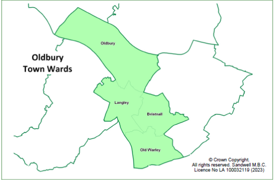
9.212 Oldbury Town is centrally located and is the administrative centre for Sandwell. It contains the wards of Bristnall, Oldbury, Langley and Old Warley. It borders Birmingham and Dudley to the south and southwest.
9.213 The populationof Oldbury town in mid-2020 was estimated to be 53,707[163]. Oldbury town has seen an increase in all age groups between 2011 and 2021, but the rise in those aged 65 and over is smaller (+2.6% and +5.3% for under 20s and 20-64s, but only 0.5% for those aged 65 and over.
9.214 Oldbury Ward has the largest population, with 15,607 residents.
9.215 41.5% of Oldbury town's population are from ethnic minorities; this is lower than the borough's average of 48% and higher than the 26% for England and Wales[164].
9.216 90% of the Lower Layer Super Output Areas (LSOAs) in Oldbury are in the 50% most deprived LSOA in England (Sandwell - 86.0%)[165].
9.217 Of the six main towns, Oldbury town has the greatest proportion of residents who are economically active (60.3%) and the second highest proportion of residents in full-time employment (34.8%).
9.218 Oldbury town has the highest level of owner-occupation of the six towns in the Borough. The proportion of households in privately rented accommodation has increased to 18.5%, which is similar to Sandwell as a whole. It has the lowest proportion of social rented housing of the six towns.
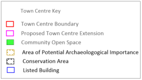
Figure 10 - Oldbury Town Centre
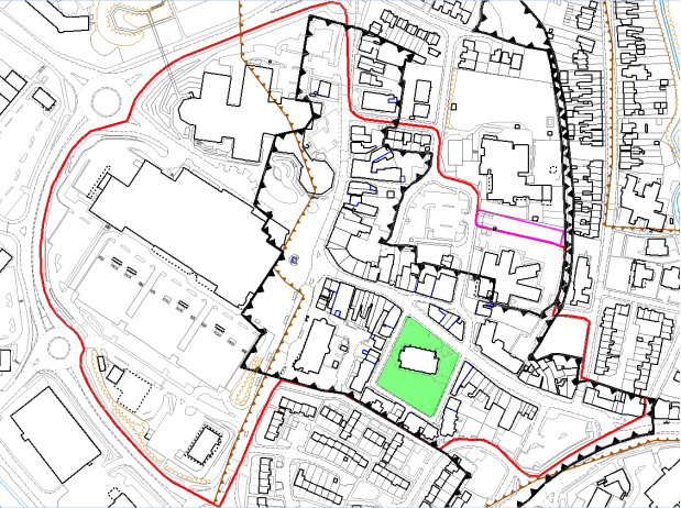
© Crown copyright and database rights 2023, Ordnance Survey Licence No 100023119
Existing Centres Boundary
9.219 The centre is designated as a town centre in the Black Country Core Strategy centres hierarchy and it is proposed to continue with this designation.
9.220 The town centre boundary is well-contained to the west by the Oldbury Ring Road. To the east the boundary follows the length of Birmingham Street to its junction on Birmingham Road. The Centres Study[166] identified that the boundary could be altered to include the whole health centre rather than the boundary intersecting it currently.
Primary Shopping Area
9.221 Oldbury Town Centre does not have an existing Primary Shopping Area (PSA) / Retail Core. Due to the nature of Oldbury as more of a service driven Town Centre, a PSA / Retail Core is not considered necessary.
Retail and Town Centre Uses
9.222 Oldbury is the only town centre in the Oldbury wards. It predominantly consists of the Sainsbury's supermarket / parking, the Sandwell Council offices and a variety of commercial units along Halesowen Street, Church Street and Birmingham Street.
9.223 Latest available information[167] details that the centre in total currently has 95 outlets with a combined floorspace of approximately 25,500 sqm. Since 2016 there has been an increase of eight outlets and some 2,350 sqm in terms of floorspace. The increase in floorspace is seen across all goods categories except for leisure services. The centre currently has 14 vacant outlets, compared to the nine reported in 2016.
9.224 The Black Country Centres Study 2020[168] identified that Oldbury comprised 7% comparison goods of Oldbury's number of commercial units, 8% below the national average. Whereas convenience goods comprised 47% of the centre's total commercial floorspace compared to 9% nationally. Sainsbury's represents 97% of the convenience goods floorspace, accounting for the small number of units but high volume of floorspace.
9.225 Financial and business services and retail services provide a more than average number of units (12% and 17% above the average respectively) but provide floorspace figures comparable to the average, suggesting a high volume of small floorplate stores. Leisure services are under-represented both in terms of number of units and their floorspace.
9.226 In accordance with Policy SDM6, the HFT threshold for Oldbury town centre is 7%; in 2022 the percentage of HFT in the centre was 5.7%.
Facilities Provision
9.227 The centre is supported by a small range of community facilities including five churches, two schools, a library, health centre and Sandwell Council's main offices.
Accessibility
9.228 Oldbury Town centre is close to a major motorway junction (M5, Junction 2). It is served by Sandwell and Dudley railway station, which lies on the edge of the town centre, offering direct inter-city trains to Birmingham International Airport, London and the north-west.
9.229 Oldbury bus interchange is situated in the middle of the town and is well-connected to the wider area, with excellent links to Walsall, West Bromwich and Birmingham.
9.230 There are two core walking zones around Sandwell and Dudley and Langley Railway Stations.
Accessibility – Provision for Cyclists
9.231 Oldbury Town Centre is served by the National Cycle Network Route No.81.
9.232 Proposed SCWIP route 4 A4034, from Oldbury Town Centre to Blackheath Town Centre via Birchley Island, will see a major junction improvement. The cycle route is at preliminary design stage and will be delivered incrementally.
9.233 Another West Midlands LCWIP cycle route runs from Sandwell and Dudley Railway Station to Cradley Heath via Langley and Blackheath. This route connects to proposed SCWIP cycle route 5 from Oldbury Town Centre to Bearwood via the Sandwell Aquatic Centre
9.234 SCWIP Cycle Route 6 A457 (Air Quality Hot Spot) Oldbury Town Centre to Smethwick Galton Bridge Railway Station is currently at Strategic Outline Business Case stage; the section from Smethwick Galton Bridge to Rolfe Street Railway Station was delivered under Towns Fund (accelerated fund). Further phases to the junction of Grove Lane and Cranford Street are being delivered via Towns Fund over the next three financial years. The route will connect with West Midlands Metropolitan University Hospital and Birmingham Cycle Network
9.235 SCWIP cycle route 3 is proposed from Great Bridge Town Centre to Roebuck Lane (National Cycle Route 5) via Brandon Way, Kelvin Way and Kenrick Way
Accessibility – Transport Proposals
9.236 The A4123 is subject to a proposed multimodal corridor improvement project that intersects with the A4034 at Birchley Island. Phase one has been delivered, from Tipton Road to Burnt Tree junction, and Phase 2 (Burnt Tree junction to Lower City Road) is under development. This route will be delivered incrementally up to Hagley Road
9.237 There are bus priority measures proposed from Dudley Road, through the junction of Oldbury Ringway / Freeth Street.
9.238 The Birchley Island / M5 Junction 2 link project[169] lies at the intersection of the M5, A4123 and A4034 in Sandwell. These routes connect Birmingham, Blackheath, Dudley, Oldbury, Walsall, West Bromwich and Wolverhampton to each other as well as linking much of the southern part of the Black Country to the national motorway network.
9.239 Works to improve the junction and its accessibility were scheduled to start in 2023 but this has now been pushed back to 2024 / 2025. Several upgrades will be made to this junction, including the addition of a fourth lane for all traffic; extending the length of Lane 3; creating segregated cycle tracks / footways; installing controlled crossings; and road widening. These works will address ongoing issues at the junction and improve road user experience.
9.240 The junction improvement is a crucial part of the Black Country transport network and is of importance to both commuters and businesses.
Environmental Quality
9.241 Existing green space designations are supported and the valuable contribution that they make is recognised.
9.242 There is important established green planting and tree coverage that contributes to the setting of areas and public spaces in Oldbury. This includes areas around Sainsburys and the council offices and a variety of public spaces and they provide valuable areas for people to stop and rest.
9.243 Other areas on Birmingham Road could benefit from public realm and shop front improvements, which could make the centre more attractive, helping to attract new businesses to the area and reduce the number of vacant commercial units.
Historic Environment Allocations
9.244 Oldbury Conservation Area was formally designated in March 1974 and reassessed in 2008. Currently the Oldbury Conservation Area centres on Church Square and Unity Place, which is the focal point of the core town centre. The area was substantially built before 1857 at a time when Oldbury was a nationally important industrial centre. This is reflected in the quality of the buildings, many of which, by virtue of their individual character and their relationship to the surrounding spaces and buildings, make a positive contribution to the quality of the environment.
9.245 The Town Centre features 19 Grade II and one Grade II* listed buildings, with most of them falling within the conservation area. Many of the listed buildings and others present attractive early to mid-19th Century styles that provide the centre with a distinct character.
SWOT
9.246 The Centres Study Health checks noted the following characteristics for Oldbury:
|
Strengths
|
Weaknesses
|
|
Opportunities
|
Threats
|
Aspirations
9.247 The large number of bus services and levels of parking make Oldbury very accessible; however, consideration should be given to better integrating the Town Centre with Oldbury Green retail park.
9.248 The upgrade of building stock within Oldbury Town Centre to encourage businesses to grow and create new jobs, considering the Conservation Area designation, will be supported.
9.249 Opportunities to provide improved public and active transport, to provide more cycle lanes should be investigated.
9.250 Encouraging active uses towards the eastern end of Birmingham Road would help to increase the sense of safety. Improving the environment on Birmingham Road may also help to attract businesses.
9.251 Residential use on the upper floors in Oldbury Town Centre is considered an appropriate use.
9.252 Opportunities will be sought to secure funding to improve the appearance of shop frontages and the general environmental quality of the area.
9.253 The Council have secured funding from UK Shared Prosperity funding to create a work business hub at Jack Judge House.
Proposals
|
Ref |
Location |
Indicative Land Use |
|
OL1 |
Town Centre |
An amended boundary is proposed, as shown in Figure 10, to include the whole health centre on Birmingham Street. |
[163] Sandwell Trends - https://www.sandwelltrends.info/oldbury/
[164] Sandwell Trends – Census Sandwell Profile - https://www.sandwelltrends.info/wp-content/uploads/sites/5/2023/04/Sandwell-Census-Profile-2021.pdf
[165] Sandwell Trends - https://www.sandwelltrends.info/wp-content/uploads/sites/5/2022/09/Oldbury-Town-Profile-September-2022.pdf
[166] Black Country Centres Study 2020, Volume 2: Healthchecks
[167] Experian Goad data for Oldbury (March 2022)
[168] Black Country Centres Study 2020, Volume 2: Healthchecks