Draft Regulation 18 Sandwell Local Plan
(4) Introduction
Purpose of the document
- The Sandwell Local Plan (SLP) contains strategic and non-strategic planning policies and land allocations intended to support the growth of Sandwell over the years to 2041. It has been prepared and approved for consultation by Sandwell Metropolitan Borough Council, referred to in this document as the Council.
- The draft SLP contains a Vision for Sandwell in 2041, underpinned by strategic objectives and priorities designed to deliver the Vision and its associated objectives. The planning policies will guide land use and development across the borough and set strong standards for growth and transformation.
- Once adopted, the SLP will provide a clear and robust strategy for bringing land forward, with a strong presumption in favour of sustainable development on previously-developed land. It will provide certainty and transparency to residents, businesses and developers around how Sandwell is expecting to grow to 2041.
(1) Why does Sandwell need a Local Plan?
- National planning legislation requires all local authorities to develop a long-term plan that sets out how and where land can be developed over a minimum timescale of 15 years, to meet the needs of local people and businesses. The SLP, which sets out strategic and development management policies[1] for Sandwell, will provide a policy framework to:
- provide certainty over the types of development that are likely to be approved;
- address the issue of climate change;
- protect and enhance designated areas of ecological and environmental importance;
- promote and enhance health and well-being in accordance with health and well-being strategies;
- facilitate the delivery of the right development to meet identified and emerging needs in sustainable locations;
- help address housing needs between now and 2041;
- attract new businesses and jobs and offer existing businesses the space to grow by meeting employment land needs;
- increase employment opportunities;
- support the aims of wider Black Country and West Midlands Combined Authority economic strategies;
- prevent uncoordinated development;
- ensure infrastructure, such as roads, public transport, new schools, new healthcare facilities, upgraded utilities and broadband, waste and sewage disposal, is provided at the right time to serve new homes and employment provision.
What will the Local Plan replace?
- When adopted the SLP will replace the Black Country Core Strategy (adopted in 2011), the Sandwell Site Allocations and Development Plan Document (the SAD, adopted in 2012) and Area Action Plans for West Bromwich, Smethwick and Tipton.
- It will also incorporate elements of former supplementary planning documents as appropriate and will include details from the West Bromwich Masterplan and Interim Planning Statement.
The Context of the Local Plan
- The SLP has been prepared in the context of national and local guidance and strategies. A range of evidence has also been commissioned by the Council to justify the draft spatial strategy and draft policies within this plan, which will be available to view on the Sandwell local plan web page alongside the consultation documents.
National Planning Policy Framework (NPPF)
- The NPPF sets out the Government's planning guidance for England and how it should be applied. It provides the framework within which locally-prepared plans for housing and other development will be produced.
- Planning law requires that applications for planning permissions are determined in accordance with the development plan, unless material considerations indicate otherwise. The NPPF must also be taken into account when preparing the development plan and is a material consideration in planning decisions. Planning policies and decisions must reflect relevant international obligations and other statutory requirements.
(19) Duty to Co-operate
- The Localism Act (2011) introduced a requirement on all local authorities to co-operate with neighbouring local authorities and other bodies with a regulatory or strategic interest in Local Plan issues. The duty requires ongoing, constructive and effective engagement on plan-making, which may have strategic cross-boundary implications.
Black Country Strategic Economic Plan
- The Black Country Strategic Economic Plan (SEP) sets out the vision, objectives, strategy, and actions to improve the quality of life for everyone who lives and works in the Black Country, an area with unique assets, challenges, and opportunities. In May 2019 the West Midlands Combined Authority, in partnerships with the region's three Local Enterprise Partnerships (Black Country, Coventry and Warwickshire and Greater Birmingham and Solihull), published the West Midlands Local Industrial Strategy[2], building on local Strategic Economic Plans.
West Midlands Combined Authority
- The West Midlands Combined Authority (WMCA) seeks to deliver a vision of a more prosperous West Midlands. The Strategic Economic Plan (SEP) sets out the vision, objectives, strategy and actions needed to improve the quality of life for everyone who lives and works in the West Midlands.
- To deliver success for the West Midlands, the West Midlands Local Industrial Strategy was agreed with government and published in May 2019. It sets out various priorities intended to help increase the productivity of the West Midlands.
- The Sandwell Local Plan will provide a basis for public and private investment decisions in Sandwell, including for Towns Fund projects and devolved housing and land funds. Sandwell Council will continue to work with the WMCA and neighbouring authorities to ensure that investment and delivery in the Black Country continues across the plan period.
(1) Previous consultations on the Sandwell Local Plan
- The preparation of the draft SLP commenced in late 2022 with the production of an Issues and Options Review, on which public consultation was undertaken early in 2023. This used both traditional and online mechanisms to support consultation and draw responses from residents, the development industry and statutory bodies.
- A total of 265 representations were received from stakeholders, developers and members of the public, covering various issues including the need to address climate change, protect open spaces, promote accessible and sustainable travel, deliver sufficient additional housing to meet Sandwell's needs and preserve the historic environment, ecology and canals.
- In addition, 18 sites were identified through a Call for Sites exercise that ran at the same time as the consultation, identified by landowners and promoters / consultants. These were assessed as part of the SLP Site Assessment process.
- Following the Issues and Options consultation the next stage of the Plan is the production of this draft version. When producing the Draft Plan, the Council considered the representations received to the Issues and Options consultation, along with a range of evidence produced to inform decision-making. Consultation on the Draft Plan (Reg18) will take place in late 2023.
- The draft SLP is supported by a Sustainability Appraisal and Habitat Regulation Assessment. It also contains a series of appendices in an annex to this main document, which should be considered in accordance with the plan where necessary
Black Country Core Strategy
- The Black Country encompasses the areas administered by Dudley Metropolitan Borough Council (MBC), Sandwell MBC, Walsall MBC and the City of Wolverhampton Council (CWC). The four authorities worked together to produce the Black Country Core Strategy, which was adopted in 2011. The existing Core Strategy provides the framework for various Site Allocation Documents and Area Action Plans, which themselves set out local policies and site allocations for individual authority areas.
- The Core Strategy covers the period between 2006 and 2026. From the outset there was a clear intention to review it five years after adoption, to ensure the spatial objectives and strategy were being effectively delivered and to keep the plan up to date. This is in line with national planning guidance. The most immediate issues both Sandwell and the Black Country are facing is that both their population and economy are continuing to grow and as a result there is a need to identify additional housing and employment sites. This demand is now beyond the capacity of' the existing Strategy to address.
- The national economic situation has also changed. The existing Core Strategy was prepared as the country was emerging from the global recession of 2008, and the Black Country was recovering from a period of economic and population decline. This was reflected in the Core Strategy in a clear emphasis on the recycling of land previously in industrial use to provide for housing and newer employment activities such as offices. However, the manufacturing and industrial markets of the Black Country remained stable and have grown in some cases, meaning that the expected surplus of vacant brownfield land available for additional housing has not occurred in practice. There is now a significant demand for additional land to meet employment needs across the area.
- Looking to the future, the opening of HS2 and the extension to the Midland Metro are likely to have a significant impact on the wider Black Country in the medium to longer term. There have also been several changes to national policy, including a revised national planning policy framework in 2021 and associated guidance, national design guidance and changes to building regulations and environmental legislation.
- More recently, the COVID19 pandemic in 2020 – 2022 caused a significant shift in the way the sub-region's residents work, shop and access services. There are likely to be some longer-term changes in the way communities operate that will have implications for land uses, and the SLP will seek to address those issues using robust, flexible and sensitive policies focussed on Sandwell's needs and aspirations.
(1) Sub-regional Context
- The Black Country forms a distinctive sub-region on the western side of the West Midlands conurbation, close to the City of Birmingham. It shares an eastern boundary with Birmingham and to the north, west and south it is bounded by districts within Staffordshire, Shropshire and Worcestershire. It is in relatively close proximity to centres such as Cannock and Bromsgrove. It has a unique and rich economic history, settlement form and topography / geology and is very much shaped by its industrial past.
- The four local authorities within the Black Country face a similar set of social, economic, and environmental challenges and have found it effective to tackle many strategic issues on a cross-boundary basis. The authorities have worked closely together since the early 2000s to establish a clear and collective set of ambitions and directions of travel, expressed in an agreed economic and spatial strategy. Joint working has strengthened and deepened over that time – moving from establishing a 30-year Vision in 2003, to adopting a Joint Core Strategy in 2011, through to securing funding through the Black Country LEP and the West Midlands Combined Authority in 2017 to deliver priority projects.
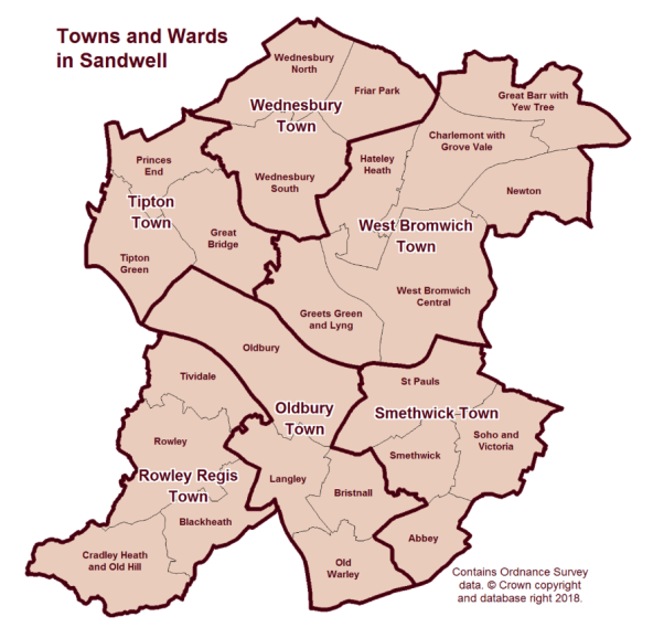
(5) Sandwell Spatial Portrait
- Background: Sandwell is a multi-centred and highly urbanised metropolitan borough. It comprises six historic former boroughs:
- Oldbury;
- Rowley Regis (including the town centres of Blackheath and Cradley Heath);
- Smethwick (including the town centres of Bearwood and Cape Hill);
- Tipton (including the town centre of Great Bridge);
- Wednesbury;
- West Bromwich.
- These historic former boroughs all maintain their own distinct identities and local communities. West Bromwich is designated as Sandwell's strategic centre and is the largest town in the borough, while Sandwell Council House (the headquarters of the local authority) is situated in Oldbury, the main civic centre.
- The Metropolitan Borough of Sandwell was formed in 1974 under the Local Government Act 1972 and is an amalgamation of the former county boroughs of Warley and West Bromwich, which in turn had been created from the previous boroughs of Oldbury, Rowley Regis, and Smethwick (Warley County Borough), and Tipton, Wednesbury and West Bromwich (West Bromwich County Borough).
- Historically, metalworking in Sandwell dates from the Middle Ages, and coal was mined from the 13th century onwards. Sandwell's main industrial growth, based on local coal and ironstone reserves, followed the coming of the canals in the 18th century. Several ironworks were established here, including the Soho Manufactory (1761) at Smethwick, which was associated with the engineers James Watt and Matthew Boulton.
- Sandwell is bordered by the cities of Birmingham and Wolverhampton and the metropolitan boroughs of Dudley and Walsall. Spanning the borough are the parliamentary constituencies of West Bromwich West, West Bromwich East, Warley and part of Halesowen and Rowley Regis, which crosses into the borough of Dudley.
- The borough covers an area of 86 square kilometres. It contains 1,200 hectares of parks, playing fields and local green space and around 66km of canals.
Figure 1 - Sandwell Metropolitan Borough
- The borough has excellent access to the wider national motorway network via two junctions of the M5 motorway (Junction 1 of the M5 in West Bromwich and Junction 2 of the M5 at Birchley Island), and two junctions of the M6 motorway (Junction 7 of the M6 at Great Barr and Junction 9 of the M6 at Wednesbury), which in turn serves the southwest, southeast and northwest regions of the UK. Sandwell also benefits from access to the national railway network via a mainline station (Sandwell and Dudley Railway Station), and the Midland Metro runs between Wednesbury and Birmingham city centre with a 15-minute journey time.
- In recent years, Sandwell has seen the successful delivery of several prestigious and highly visible projects and developments and this transformational growth trend is continuing. Projects that have been undertaken include:
- Sandwell Aquatics Centre – the brand-new centre was built and delivered in time for the 2022 Birmingham Commonwealth Games and was used throughout the Games for swimming and aquatics events. Following the Games, the venue has been refurbished into a community health and wellbeing asset;
- Birchley Island – a £25.5m scheme to improve connectivity to the adjacent M5 Junction 2 by providing a new through lane for improved motorway access, enhanced facilities for pedestrians and cyclists and widened connected roads with signal control;
- Elite Centre for Manufacturing Skills: National Foundry Training Centre - as part of the £12.7m Elite Centre for Manufacturing Skills scheme, this centre provides access to industrial facilities and a purpose-built training block of 950 sqm in Tipton;
- Wednesbury to Brierley Hill Metro Extension via Dudley – this will create a direct public transport route from Wednesbury to the Wolverhampton to Walsall rail line at the Dudley Port interchange.
- Demographic Trends[3]: The 2021 Census estimates that Sandwell has 341,900 residents, a rise of 11.0% since 2011. This compares with a rise of 6.3% in England and Wales. The 11% rise in Sandwell since 2011 is the highest in the West Midlands Metropolitan County area, the next highest being in Coventry (8.9%).
- In 2021, Sandwell ranked 27th for total population out of 309 local authority areas in England, moving up six places in a decade. The borough's population is predicted to grow at a faster rate than both the population of the West Midlands and the national average and is forecast to increase by 30,000 between 2016 and 2030. This area is the second-most densely populated local authority area across the West Midlands (after Birmingham)[4].
- Sandwell has a young and diverse population, with more than 40% of its residents under the age of 30, compared to around 30% elsewhere in the UK. Just over 40% of residents are from an ethnic minority background, making the population more diverse than the regional and UK average of 18.8% and 14% respectively.
- The most common main languages spoken in Sandwell, other than English, are Panjabi (6.4%), Polish (1.7%), Bengali (1.0%) and Urdu (1.0%).
- Health - the health of people in Sandwell does not on the whole compare well with England averages. Sandwell is one of the 20% most deprived districts / unitary authorities in England and around 25.5% (18,495) of its children live in low-income families. Life expectancy for both men and women is lower than the England average; 76.1 years for men and 80.7 years for women compared to 79.4 years (male) and 83.1 years (female) nationally[5]. Life expectancy inequality also exists within Sandwell itself – life expectancy is 8.6 years lower for men and 8 years lower for women in the most deprived areas of the borough compared to the least deprived areas[6].
- Economy and Skills: Sandwell has a long history of industrial activity, especially in manufacturing. Until the 1980s the Black Country, together with neighbouring Birmingham, was the powerhouse of Britain's manufacturing economy. The recessions in the early 1980s and during 2008 – 09 had significant and lasting adverse impacts on the local economy and saw the loss of a significant number of companies and a high level of unemployment, but the sub-region has recovered
- The West Midlands was one of the hardest hit parts of the UK economy during the COVID19 pandemic[7]. Sandwell's demography and urban structure exposed it to Covid, most notably in its central corridor of older, poor-quality housing and in ethnic minority groups where infection rates were highest.
- The impact of successive lockdowns in 2020-21 that were needed to contain the pandemic caused significant economic damage. Sandwell was already in recession when COVID hit and subsequently experienced many business failures, most visibly in high streets, and widespread rises in unemployment, particularly among young people.
- Sandwell borough is almost the same size in population terms as Nottingham and is bigger than Newcastle, Oxford, and Milton Keynes, but those locations all have larger economies than Sandwell.
- Sandwell has many growing and productive businesses and a higher-than-average proportion of its businesses are small, but residents are not always able to take up opportunities related to those employment and economic activities. Local businesses will often need a highly skilled workforce to be able to grow to meet modern demands; that workforce needs training and support to help deliver and accelerate innovation. Sandwell also has a limited amount of the type of high-quality land needed to enable businesses to expand and grow in the borough's industrial core.
- Productivity - Sandwell's economy (Gross Value Added) was worth £6.644 billion in 2020[8], which represents a value of £20,192 per head. While lower than both the West Midlands Metropolitan Area and the UK averages, Sandwell's productivity is higher than that of the other authorities in the Black Country.
- Business Population - Sandwell has around 11,600 active business units[9]:
- 9,585 (82.6%) are micro businesses;
- 1,970 (17.5%) are Small and Medium Enterprises; and
- 50 (0.4%) are large units.
- Of these businesses, only 40 are designated as 'high growth' enterprises[10]. There is however evidence of a considerable entrepreneurial spirit in the area, with approximately 1,775 new businesses being created and 915 shutting down annually.
- Economic Activity - In Sandwell, 71% of employees work full time, with 29% working part time[11]. The challenge in Sandwell is in maintaining positive economic growth and keeping it moving forward, particularly following the COVID19 pandemic, and ensuring growth is sustainable.
- Two other factors that had a major underlying legacy effect on Sandwell's economy were:
- the global financial crisis of 2007-2008, which reduced access to private sector finance;
- a sustained period of public sector austerity beginning in 2010; this reduced both the overall ability of local government to protect vulnerable communities and reduced their capacity to spend locally on projects that helped deliver economic growth to businesses and better prospects of employment and skills to residents.
- During the early 2020s a range of economic shocks (including the COVID19 pandemic, the UK's exit from the EU market in 2020, higher inflation and a more volatile energy and commodity market ensuing from the Russian invasion of Ukraine in 2022) have resulted in challenges for businesses of all sizes. Other significant changes to the economy have occurred through changes in working patterns, such as a significant rise in the number of Sandwell residents now working from home.
- It is within the context of this period of economic instability that the SLP is being developed. In effect this means that the underlying resilience of the local economic base has been through a significant period of disruption. In terms of its approach, Sandwell Council has had to prioritise a range of measures that have helped to mitigate the impacts of the current cost of living crisis on both local communities and businesses.
- Ensuring economic growth is sustainable remains a major priority for future development in Sandwell and the SLP delivers a key part of that process by identifying the right sites and policies to support economic growth.
- Sandwell has a higher-than-average level of economic inactivity and unemployment.
Table 1 - Employment and Unemployment in Sandwell[12]
|
Economic Activity |
Sandwell Numbers |
Sandwell % |
West Midlands Met % |
Great Britain % |
|
Economically Active |
151,100 |
69.1 |
77.5 |
78.4 |
|
In Employment |
142,000 |
64.7 |
73.6 |
75.5 |
|
Employees |
125,100 |
57.3 |
64.9 |
66.0 |
|
Self Employed |
16,300 |
7.0 |
8.4 |
9.2 |
|
Unemployed |
9,100 |
6.0 |
4.8 |
3.6 |
- Over the same period, NOMIS identified that 66,900 residents (32% of residents aged 16 - 64) were economically inactive (compared with 21.6% in Great Britain)[13].
|
Economically Inactive (age 16-64) |
Sandwell Nos. |
% of overall workforce |
|
Total Inactive |
64,400 |
30.9% |
|
Students |
11,700 |
18.2% |
|
Looking After Family / Home |
18,600 |
28.9% |
|
Long-Term Sick |
20,500 |
31.8% |
- 6% of the working population are classed as unemployed[14] (as a proportion of economically active residents), with 14.2% of households classed as 'workless'[15] (where households contain at least one person aged 16 to 64 and where no-one aged 16 or over is in employment). Gross weekly incomes are below the national average, with the Sandwell median average wage for full-time workers being £549 per week compared to a national average of £642[16].
- Qualifications and Skills: Around a third of the Sandwell working age population are graduates. This is significantly lower than the UK average rate for the equivalent group, forming the most highly skilled band of National Vocational Qualification (NVQ) level 4 or above. As a result, Sandwell has a smaller pool of workers able to compete for more highly skilled vacancies. 11.5% of the Sandwell working age population have no qualifications at all, which figure is around three quarters' higher than the UK average. This means that the Sandwell workforce are more likely than those in the rest of the UK to work in lower skilled occupations.
- Employment: In terms of job numbers, the three main employment sectors in Sandwell are retail and wholesale, manufacturing and health and social care. In terms of critical or Sandwell-specific sectors, where Sandwell plays a stronger or more disproportionate role within the wider economy than the national average, the highest contributors are manufacturing (+111% greater than the national average); electricity, gas and air conditioning (+100% greater); water supply and waste management (+71% greater); transportation and storage (+59% greater); and retail and wholesale (+40% greater)[17].
Table 2 - Distribution of Jobs in Sandwell
|
Sandwell Economic Sectors |
Workers |
% of workers |
Compared to UK average |
|
Wholesale, Retail & Vehicle Repair |
25,000 |
20.2 |
+40% |
|
Manufacturing |
20,000 |
16.1 |
+111% |
|
Health & Social Care |
16,000 |
12.9 |
-6% |
|
Transportation & Storage |
10,000 |
8.1 |
+59% |
|
Education |
10,000 |
8.1 |
-8% |
|
Admin & Support Services |
9,000 |
7.3 |
-18% |
|
Construction |
7,000 |
5.6 |
+14% |
|
Accommodation & Food Service |
6,000 |
4.8 |
-36% |
|
Professional, Scientific & Technical |
5,000 |
4.0 |
-55% |
|
Public Administration & Defence |
3,500 |
2.8 |
-39% |
|
Other Service Activities |
3,500 |
2.8 |
+32% |
|
Arts, Entertainment & Recreation |
2,500 |
2.0 |
-13% |
|
Real Estate |
2,500 |
2.0 |
+11% |
|
Water Supply & Waste Management |
1,500 |
1.2 |
+71% |
|
Information & Communication |
1,500 |
1.2 |
-73% |
|
Finance & Insurance |
1,250 |
1.0 |
-72% |
|
Electricity, Gas & Air Conditioning |
1,000 |
0.8 |
+100% |
- Workforce and travel to work: each day, 59,000 people come into Sandwell from neighbouring areas to work, and almost 62,000 of Sandwell's residents work outside the Borough. The job density per working age population is 0.63, compared to 0.80 in the West Midlands Metropolitan area and 0.84 in the UK.
- Housing: In March 2021[18], Sandwell had 130,246 household spaces. 54% of households were in owner-occupation, 27% were social rented and 19% were rented from a private landlord. The average household size in Sandwell is 2.42, which is slightly above the England and Wales average of 2.4. In terms of household composition, in 2021, 38,042 households in Sandwell are made up of only one person, which equates to just under 30% of the total.
- Transport: Sandwell lies at the heart of the national Strategic Road Network. The intersection between the M5 and M5 motorways is in the north of the borough and four motorway junctions, Junctions 7 and 9 of the M6 and Junctions 1 and 2 of the M5, provide access to and from all parts of the borough. The local road network consists of 880km (547 miles) of highways, including the strategic A41, A461, A457 and A4123 routes, which link the borough's centres to each other, the wider Black Country and Birmingham.
- There are three rail lines, serving thirteen stations, that pass through the borough;
- the Stour Valley section of the West Coast Mainline provides local services from Tipton, Oldbury and Smethwick to Birmingham and Wolverhampton as well as inter-city links to London and the north;
- the Chase Line links Birmingham New Street to Walsall and Cannock and serves the north of Sandwell;
- the Birmingham Snow Hill to Worcester line serves Smethwick and the southwest of the borough.
- In addition, large parts of the borough are served by the West Midlands Metro network, which provides connections to Birmingham and Wolverhampton. An extension to Dudley Town Centre is expected to open in 2024, with a further phase to Brierley Hill expected to complete at a later date.
- To complete the picture, there is an extensive 66km (41 mile) canal network throughout the borough.
- The Covid19 pandemic combined with the shift to home working, particularly in the office sector, has changed the way people move around; this is true of both the times at which they make journeys and the mode by which these journeys are made.
- Car use has returned almost to pre-pandemic levels, with 1.29bn vehicle miles being travelled on Sandwell's Roads during 2022, which is around the same as the figure for 2016 and is approaching the record peak of 1.35bn vehicle miles seen during 2019. The 2023 figures are expected to continue this upward trend[19].
- In contrast the number of public transport journeys, particularly during commuter periods, has not recovered to the same degree. Bus use in 2021/22 was at around 70% of pre-pandemic levels, whilst for metro the figure was 60% and for rail it was 50%. Whilst a recovery in journey numbers has continued, the 2022/23 figures are still expected to be significantly below pre-pandemic levels. In Sandwell, bus continues to be the most important public transport mode, accounting for approximately four out of every five such journeys made.
- Centres: Sandwell's origins lie in six distinct Urban District Councils, which merged together to form a seamless and significant part of the wider West Midlands conurbation.
- Sandwell is a heavily urbanised metropolitan area, with a Strategic Centre at West Bromwich, seven town centres, thirteen district and local centres and many small parades of shops. It is a genuinely 'polycentric' borough.
- Sandwell has been subject to the same trends in retailing other areas have, but also suffers from significant levels of deprivation and lower incomes, which in turn has had an impact on retailing activity across the borough. The rise of 'big box' supermarkets, internet shopping, limited range discounters, out-of-centre retail parks and standalone out-of-centre supermarkets have all impacted on the vitality of its centres. The pandemic lockdown conversely provided a boost to local centres as people tended to shop more locally.
- West Bromwich received a major boost with the delivery of the New Square development in 2013 but has fallen back in comparative terms to other centres nationally. New Square shifted the 'centre of gravity' of the retail area, with a subsequent decline in footfall and occupancy levels at parts of its periphery towards Bull Street, but also in Queens Square. West Bromwich's vacancy rate is 17.74%, compared to 13.81% nationally (as at 2022).
- As with other urban areas, comparison shopping (i.e., for clothes, electrical goods etc.) are increasingly concentrated in the strategic centre, with other centres taking on a more services-orientated role.
- Built heritage and natural environment: Despite its industrial heritage and highly urban nature, Sandwell is home to several significant areas of green and open space, a network of wildlife corridors and sites with significant ecological and environmental value and a number of historic and architecturally significant buildings and locations.
- Sandwell is home to 204 listed buildings and nine conservation areas. There are also five designated parks and gardens (all listed at Grade II) and seven scheduled monuments[20]. There are many pressures on built heritage assets - to modernise or demolish historic buildings, change their uses, develop within heritage conservation areas and remove landscaping. Given the irreplaceable contribution heritage assets make, the government has made it clear that it is important that heritage assets and their settings are preserved or enhanced as a reminder of the history and evolution of the area.
- All features of the outdoor environment contribute to environmental infrastructure, including natural and semi-natural habitats, parks and other open spaces, formal and informal recreation and sports facilities, historic buildings and landscapes, the public realm of spaces and streets, rivers, canals and drainage systems.
- Sandwell benefits from 543 green spaces, with 323 of those spaces (59%) offering unrestricted public access. This provides 3.63 hectares of open space per 1,000 population and offers more unrestricted green space access than some comparable local authorities, including Birmingham, Oldham, Hull, and Knowsley[21]. More formal green and open spaces in Sandwell include[22]:
- 32 parks and gardens (including nine Green Flag parks)
- 211 amenity green spaces (from small local spaces to larger communal green spaces)
- 75 natural and semi-natural green spaces (including nine recognised nature reserves)
- 22 green corridors (such as green walkways and other networks that connect areas)
- 48 outdoor sports sites (including 15 playing pitches, 27 Multi-Use Games Areas, 33 outdoor gyms, four bowling greens and 12 BMX and skate facilities)
- 34 allotment sites (with 1,336 plots)
- 69 play areas (including toddler and junior play facilities).
- Following aerial surveys completed as part of the recent Black Country iTree project[23], it is estimated that Sandwell contains around 265,000 trees, covering 18.1% of the borough. This is higher than the UK average of 16%. It is estimated that 81% of these trees are in good or excellent condition.
- Broadband and 5G: Sandwell has high levels of broadband connectivity – in May 2022 84.1% of premises were gigabit capable, compared to 66.6% in the UK. 85% of premises had speeds equal to or greater than 300 Mbit/s, compared to 68% in the UK. As at December 2022, Sandwell had superfast broadband coverage of approximately 99.7% and full fibre coverage of 40.49%; this compares to the UK average for superfast broadband of 97.4% and full fibre coverage of 45.1%[24].
Challenges and Issues
- The following summarises the key strategic challenges and opportunities that have arisen since the Core Strategy was adopted in 2011. These issues form the main opportunities and challenges which the Plan Strategy, objectives and suite of policies and proposals seek to address:
- Climate change and protecting and enhancing the environment - the Plan needs to address the challenge of mitigating and adapting to the impacts of climate change in ensuring sustainability principles are embedded across all areas. It will also need to create a strategy for the enhancement and protection of Sandwell's environment and make provision for new environmental infrastructure required to support sustainable growth.
- Providing good quality housing that meets the needs of a growing population - the Plan needs to identify sufficient land for housing to meet the needs of people who are likely to live in the area over the period of the plan.
- Supporting a resurgent economy, which provides access to employment and opportunities for investment - the Plan should provide for a range of employment sites capable of meeting a wide variety of investment needs.
- Supporting strong and competitive centres - to address the health and enhance the vitality and viability of our centres and ensure Sandwell has realistic ambitions for growth. The Plan should provide a flexible policy framework to allow centres to serve the future growth identified in Sandwell (particularly housing and employment), diversify and provide strict tests to defend against proposals that could undermine centres, such as out-of-centre developments.
- Keeping Sandwell connected - a balanced approach to transport investment is required that recognises the need to invest in all modes of transport but identifies a priority in increasing the proportion of people using public transport, walking and cycling.
- Providing infrastructure to support growth - physical and social infrastructure is required to enable and support the growth required over the plan period. New housing and economic development will put pressure on existing services and utilities but may also create opportunities to provide infrastructure solutions.
- Health and Wellbeing- The role of the environment in shaping the social, economic and environmental circumstances that determine health and wellbeing is increasingly recognised and understood. The SLP seeks to address this.
Draft Sandwell Local Plan - contents
- The Plan is structured as follows:
- Section 1 sets out how the Plan has been prepared and establishes the local context, highlighting the strategic challenges Sandwell faces.
- Section 2 provides the spatial vision, strategic objectives and priorities of the Plan that provide the basis for the policy and spatial approach.
- Section 3 sets out the overall spatial strategy for Sandwell, containing overarching policies intended to deliver the vision and objectives of the Plan.
- Sections 4-15 set out the detailed policies, organised by themes and reflecting the role of the Vision in delivering sustainable growth for Sandwell.
- In addition to this, the Plan contains several appendices that address in more detail certain aspects of the Plan policies and contain information on allocated sites for both housing and employment uses. Alongside the Plan sits a focussed evidence base that contains the up-to-date information and data the Plan is based on.
- A series of topic papers have also been produced that address certain policy areas in more detail and explain the thinking behind the approach Sandwell Council has taken to the delivery of growth and development in the borough.
- The Council has also produced a paper on the background and choices related to the identification of the Spatial Strategy for the SLP, setting out the spatial and growth options that were considered reasonable alternatives. These were subject to sustainability appraisal and the outcome of this work resulted in the development strategy set out in Policy SDS1.
[1] Paragraphs 20 – 21, NPPF (2021)
[2] https://assets.publishing.service.gov.uk/government/uploads/system/uploads/attachment_data/file/802091/west-midlands-local-industrial-strategy-single-page.pdf
[3] Information in this chapter taken from Sandwell Trends, based on the 2021 census, unless otherwise stated.
[5] Public Health England - https://fingertips.phe.org.uk/profile/health-profiles/data#page/1/gid/1938132696/ati/402/iid/90366/age/1/sex/1/cat/-1/ctp/-1/yrr/3/cid/4/tbm/1
[6] Public Health England - https://fingertips.phe.org.uk/static-reports/health-profiles/2019/e08000028.html?area-name=sandwell (2019)
[7] The West Midlands showed the largest negative growth in GDP in Quarter 2 2020 when compared with the same quarter a year earlier, at 24.7%; Source: ONS https://www.ons.gov.uk/economy/grossdomesticproductgdp/bulletins/gdpukregionsandcountries/apriltojune2020
[8] Black Country Consortium Economic Intelligence Unit - https://app.powerbi.com/view?r=eyJrIjoiZGVkYjYzODMtN2Q0Ny00N2I3LWFiZmItZDE2OWZhOWI4OGViIiwidCI6ImNhM2RjZDRiLTRiNDUtNGUyMi1iODFhLWQ5NjMzZDVhOGM5ZSJ9
[9] NOMIS – Business Counts 2022 https://www.nomisweb.co.uk/reports/lmp/la/1946157189/printable.aspx
[10] A business with average annualised growth greater than 20% per annum over a three-year period is considered a high-growth enterprise. Growth can be measured by the number of employees or by turnover (Eurostat − OECD Manual on Business Demography Statistics).
[11] Census 2021
[12] NOMIS (Employment and unemployment figures for April 2022 to March 2023)
[13] NOMIS - Economic inactivity (Apr 2022 – March 2023) https://www.nomisweb.co.uk/reports/lmp/la/1946157189/printable.aspx
[14] NOMIS – Employment and unemployment (April 2022 – March 2023)
[15] NOMIS - Workless Households (Jan-Dec 2021)
[16] NOMIS – Earnings by place of residence (2022) https://www.nomisweb.co.uk/reports/lmp/la/1946157189/printable.aspx
[17] Source – ONS Business Register and Employment Survey, October 2022
[18] 2021 Census
[19] Dept. for Transport Road Traffic Statistics 2022
[20] Data from Historic England website (June 2023)
[21] Paragraph 3.3, Draft Green Spaces Strategy Implementation and Business Plan 22/23 – 25/26 – Sandwell MBC Green Spaces