Draft Regulation 18 Sandwell Local Plan
(1) Cape Hill
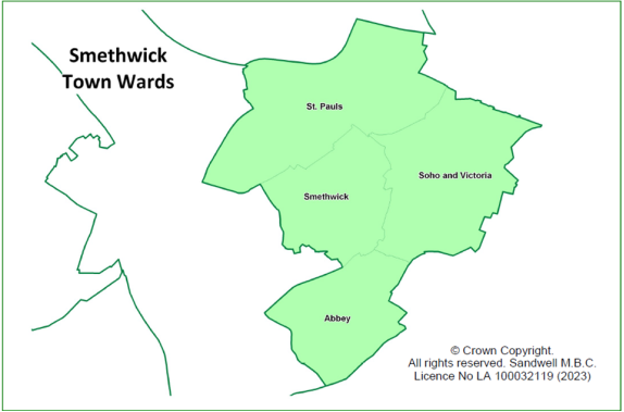
9.130 The town of Cape Hill lies within the ward of Soho and Victoria.
9.131 The population of Soho and Victoria Ward is 19,629 according to the 2021 census. This is an increase of 30.5% since the 2011 Census, which is the largest growth in population in Sandwell. Soho and Victoria is now the most populous ward in Sandwell.
9.132 Soho and Victoria ward has seen a particularly large population increase in younger age groups, with a 10% increase in the proportion aged under 20, and a 20% increase in the number of people aged between 20 - 64 (the largest increase of all of Sandwell wards for both age groups). There has also been a slight rise in those aged 65 and over.
9.133 In Soho and Victoria Ward, 90.2% of residents are from groups other than White British; it has the highest proportion of people from the Pakistani, Chinese and Asian Other, Black African and Black Other groups in Sandwell[158].
9.134 Regarding employment levels, 48.5% of residents are economically active and in employment; this is lower than the England average. Soho and Victoria Ward has the highest rate of unemployment of all Sandwell wards (6.2% of those aged 16+)[159].
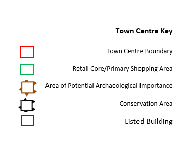
Figure 7 - Cape Hill Town Centre
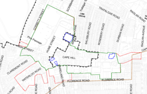
© Crown copyright and database rights 2023, Ordnance Survey Licence No AC0000824500
Retail and Town Centre Uses
9.135 Cape Hill is one of the main town centres within Smethwick. The Town Centre primarily consists of the Windmill Shopping Centre, Cape Hill Road, and sections of surrounding roads: Waterloo Road, High Street, Shireland Road, and Windmill Lane.
9.136 Cape Hill contains a retail core, which includes most of the centre. The spurs of retail activity off Waterloo Road, Shireland Road and the east side of Cape Hill from its junction at Durban Road are not included within the retail core as they lie further away from the main retail hub of the centre and have a lower footfall.
9.137 The Windmill Shopping Centre creates a greater draw while the rest of the centre acts more as a local centre serving a more immediate local need
9.138 From the 2019 Black Country Centres Study, Cape Hill demonstrated a small increase in the number of occupied commercial units within the centre. The centre tends to be busy with vehicular traffic but is not particularly busy with pedestrians, though there is a consistent amount of people throughout most of the area. The busiest area is the entrance to the Windmill Shopping Centre from Cape Hill, with many pedestrians moving between the shopping centre and eastwards down Cape Hill Road. The study also concluded that Shireland Road and Waterloo Road were equally busy.
9.139 Cape Hill had a total of 207 commercial units with a total floorspace of 38,455m2 as at 2019 compared to 198 units and 36,585m2 in 2009, suggesting a degree of overall growth in the centre in the last ten years.
9.140 Comparison goods units make up 28% of the centre's uses by number of units, 7% below the UK national average of 36%. When comparing floorspace, comparison goods make up 32% of the centre's total, exactly aligning with the national average. For a town centre this is a healthy position, although this sector has declined by 11 units and 2,056m2 floorspace since. The presence of the Windmill Shopping Centre directly within the Town Centre has a positive impact on the floorspace of comparison goods when compared to nearby Town Centres.
9.141 Convenience goods account for 20% of Cape Hill's commercial units which is 5% above the national average; the floorspace of these units makes up 37% of the centre's total, which is 28% above average. This over-representation of convenience goods floorspace can mostly be attributed to the large 6,320m2 Asda store, which represents 44% of all convenience floorspace in the centre. The second and third largest convenience stores include Windmills Market (1,510m2) and PAK Supermarkets (1,290m2). Convenience goods have increased in both number of units and floorspace (13 units and 2,908m2) since 2009. This shows that convenience retail plays a major role in the centre.
9.142 The floorspace levels of retail services, at 9%, are below the national average of 14%; however, the number of units providing retail services is higher than average at 23% compared to the national average of 7%. This shows that there is a high volume of small floorplate retail service units, which is typical for this type of centre.
9.143 Leisure services are under-represented in terms of both number of units and floorspace, falling 10% and 14% below the national average of 24% and 25% respectively. What leisure services there are, are heavily focused towards takeaways, which make up 65% of the sector. Financial and business services align to the national average for number of units at 7%, but fall 6% below average for floorspace at 10%, again highlighting the prevalence of small units. Collectively the service industry has increased by 21 units and 346m2 since 2009, which is a positive sign.
9.144 Cape Hill has a below-average level of vacancies in terms of both number of units (13 vacant) and floorspace (2,986m2), which stand at 6% and 8% respectively, both 3% below the national average. This compares well to other centres in the borough, which are experiencing above average vacancy rates. It has also improved considerably since 2009, when the vacancy rate was 14%.
9.145 Spatially, Cape Hill contains several high-density parades of small units along its main roads, with significantly larger units at the Windmill Shopping Centre and medium-sized units at the Cape Hill Retail Centre at the eastern end of Cape Hill. There is little pattern in the distribution of uses, though there is a higher proportion of comparison goods units towards the western end of Cape Hill Road. Several national multiples are also present, most of which are located within the Windmill Centre, with the remainder situated along Cape Hill Road and the retail centre.
9.146 Cape Hill has exceeded the threshold for HFTs (Policy SDM6).
Facilities provision
9.147 There are several community facilities, including several religious institutions, two primary schools and a health centre. Cape Hill also benefits from its proximity to a large green space at Victoria Park.
Accessibility
9.148 Due to the presence of multiple busy roads, the centre is well-connected for vehicles and is served by at least six different bus services to various destinations including Birmingham, Smethwick, and West Bromwich. These include the 80, 82, 897, 89, 54, and 54A[160]
9.149 There are a high proportion of pedestrian crossings at The Windmill Centre and the main junction on Cape Hill Road; this contrasts with the rest of the centre in which there is a clear lack of such crossings.
9.150 A lack of crossing points negatively impacts pedestrian flows and makes it difficult to cross busy roads without heading towards The Windmill Centre.
Accessibility – Provision for cyclists
9.151 Cape Hill forms part of the A457 corridor from Oldbury to Cape Hill, which includes SCWIP cycle route (CR) 11.
9.152 Smethwick Connected is a connectivity project promoting walking and cycling improvements between Smethwick High Street and the Midland Metropolitan Hospital. This includes walking improvements within the Windmill Eye estate, although it does not affect the High Street to any great extent. Towns Fund money is being used to deliver new cycle and pedestrian facilities along the A457 in incremental phases from Smethwick Galton Bridge Station to Cape Hill. The scheme is being delivered in different phases as follows:
- Phase 1: A two-way segregated cycle way on the south side of the A457 from Galton Station to Rolfe Street junction.
- Phase 2: A two-way segregated cycle way from Rolfe Street to Cross Street on both sides of A457. The carriageway was realigned to allow the construction of a new footway and cycleway from High Street junction to Lynton Avenue, with a link for both onto Lynton Avenue. A new traffic signal crossing was installed on the A457 adjacent to Cross Street junction. This Phase was completed in June 2023.
- Phase 3: Lynton Avenue to Metropolitan Hospital Walking Route; new and upgraded pedestrian facilities such as dropped crossing and tactile paving.
- Phase 4: A two-way segregated cycleway along the A457 from Lynton Avenue to Soho Street junction. This Phase will connect onto the end of Phase 2. This Phase is due to start in Autumn 2023, with completion expected by Spring 2024.
- Phase 5: in development as of 2023 and will be delivered by the Canal and River Trust. It includes the construction of a towpath from the canal to the path at the side of Heath Trading Park. This will then be connected to the cycle routes on Winson Street; completion is expected by November 2023
9.153 SCWIP CR11 already partially exists but it requires updating to the standards identified in the Local Transport Note 1/20 (LNT1/20). There is a £19 million budget available from The City Region Sustainable Transport Settlements (CRYSTS) funding to improve access to the hospital, which will be split between Sandwell and Birmingham and will be used to create a cycle route from the A457 to the National Cycle Network via route 5 along the Birmingham canals (NCN5), borough boundary links with Birmingham and SCWIP 11 upgrades.
9.154 There are several cycle stands provided within the Windmill Shopping centre, but these are spaced too closely together, which renders half of them effectively unusable. The current Sandwell Cycling supplementary planning guidance suggests that cycle stands should be spaced one metre apart. Every other cycle stand in the row should therefore be removed and relocated elsewhere within the vicinity.
9.155 There is a lack of provision elsewhere in the centre due to the narrow widths of the pavements.
(1) Accessibility - Transport Proposals:
9.156 Although there are no new transport proposes for Cape Hill itself, it will be impacted by the Smethwick Connected Project, which includes walking improvements within the Windmill Eye estate.
Environmental Quality
9.157 Outside of the Windmill Centre the environmental quality of the area is generally poor, with most of the shop frontages in need of significant maintenance and modernisation. Despite having a lower-than-average number of vacant units (proportionally), the low quality of the occupied properties makes the area feel like it is in a state of decline, despite figures suggesting otherwise.
9.158 The centre is dominated by rows of two to three storey terraced properties of varying styles and appearances though generally constructed of red brick. The type and quality of paving varies across the centre; Shireland Road and Waterloo Road feature mostly red and grey bricked paving, whilst Cape Hill Road comprises a mixture of concrete and dark brick. The centre would benefit from a consistent paving scheme of higher quality.
9.159 Though constrained by pavement sizes and main roads, there is a lack of any significant street furniture or decorative finishes such as a planting scheme, which would help to raise the quality of the area.
Historic Environment Allocations
9.160 There is a conservation area within Cape Hill town centre, designated in August 2012. The conservation area comprises the heart of Cape Hill and is focused on the junction of Cape Hill with Waterloo Road and Shireland Road; it runs east along Cape Hill to the junction with Rosebery Road
9.161 There are four listed buildings within the centre, including the Grade II* Waterloo Hotel. Unfortunately, these listed buildings are not being utilised to their potential and their architectural quality is let down by their vacancy (they are all vacant as at July 2023), their poor physical quality and the generally poor appearance of neighbouring units, which adversely affects their setting.
SWOT
9.162 The Centres Study Health checks noted the following characteristics for Cape Hill:
|
Strengths
|
Weaknesses
|
|
Opportunities
|
Threats
|
Aspirations
9.163 The health checks identified that there is limited evening activity due to the lack of leisure facilities around Cape Hill, including the strict definition of leisure as well as restaurants or cafes. There is just one pub and 11 restaurants, although a number of these also act as hot food takeaways.
9.164 There may also be opportunity to provide improved public and active transport links to the new aquatics centre in Smethwick from Cape Hill and other surrounding centres
9.165 Opportunities for funding to improve shop fronts and townscape quality should be investigated. Generally, frontages within Cape Hill are in a poor condition, which may adversely affect its attractiveness to potential new occupiers or for new development / investment.
9.166 There is council housing under construction (2023) to the rear of the High Street on Church Hill Street.
9.167 An increase in the number of banks and / or the introduction of a post office would mean that certain groups of the community are not excluded, and people can continue to have a physical facility to deal with financial cash transactions.
Proposals
9.168 The following locations offer opportunities for future improvements and additions to the public realm and character of the area.
|
Site |
Location |
Indicative Land Use |
|
CH1 |
The wider area outside the Windmill centre |
The environmental quality of the area is generally very poor, with most of the shop frontages in need of significant maintenance and modernisation. Opportunities will be sought to secure funding to improve the appearance of shop frontages and general environmental quality of the area |
|
CH2 |
|
There are four listed buildings within the centre, including the Grade II* Waterloo Hotel building. Unfortunately, these listed buildings are not being utilised to their potential and their architectural quality is let down by their vacancy (all vacant - 2023). Opportunities will be sought to assist developers with the upkeep of the Listed Building when planning permission is sought. |
|
CH3 |
The wider area outside the Windmill centre |
The type and quality of paving varies across the centre; Shireland Road and Waterloo Road feature mostly red and grey bricked paving, whilst Cape Hill Road comprises a mixture of concrete and dark brick. The centre would benefit from a consistent paving scheme of higher quality |
[158] Taken from Sandwell Trends, source: 2021 Census
[159] Source: 2021 Census (Sandwell Trends)
[160] Transport for West Midlands - Sandwell-Dudley-area-map-20230625.pdf www.tfwm.org.uk