Draft Regulation 18 Sandwell Local Plan
Ended on the 18th December 2023
(1) APPENDIX A – Nature Recovery Network and Biodiversity Net Gain
Black Country Local Nature Recovery Opportunity Map
- The development of a Nature Recovery Network (NRN) covering the whole of England is a major commitment in the Government's 25 Year Environment Plan (2018). The plan states that the development of the NRN will provide 500,000 hectares of additional wildlife habitat, more effectively linking existing protected sites and landscapes, as well as urban green and blue infrastructure; and that as well as helping wildlife thrive, the NRN could be designed to bring a wide range of additional benefits: greater public enjoyment; pollination; carbon capture; water quality improvements and flood management.
- The Environment Act 2021 made Local Nature Recovery Strategies mandatory in England. Together the strategies are to cover the whole of the country, and the Secretary of State is to determine the areas within England to which individual Local Nature Recovery Strategies are to relate.
(1) Black Country Local Nature Recovery Opportunity Map (draft April 2021)
- A requirement of the Environment Act 2021 is a Local Habitat Map that identifies the existing distribution of different habitat types and the location of areas already important for biodiversity, overlaid by locations considered suitable for delivering the outcomes and measures identified in the Statement of Biodiversity Priorities.
- The emerging Sandwell Local Nature Recovery Opportunity Map forms part of a Birmingham and Black Country-wide map and strategy approach which has been produced by the Wildlife Trust for Birmingham and the Black Country and the Local Environmental Records Centre (EcoRecord). This has been undertaken through analysis of local and national data sets including designated sites, Priority habitats, species distribution, land use and ecological connectivity. The map comprises a number of components that depict the areas of current high ecological value, ecological connectivity between these areas, and prioritises opportunities for investment in nature's recovery on a landscape scale.
Core Landscapes
- Core Landscapes are large areas of land comprised of multiple land use parcels that are ecologically coherent, often sharing similar geology, soil types, habitats, landscape character and land use history. They are frequently those areas less impacted upon by urban development and often support features more typically associated with rural landscapes. Core Landscapes typically support the highest abundance and diversity of semi-natural and Priority Habitats, and the species assemblages associated with these. They provide significant opportunity and are a priority for investment in ecological recovery (e.g. habitat restoration and creation).
Priority Network Restoration Zone
- Priority Network Restoration Zones are areas where investment in ecological recovery outside of Core Landscapes has been prioritised. These zones have been selected on the basis of being those areas that contain the highest density of Core Habitat and Core Expansion land use parcels which collectively link Core Landscapes (or their component parts), and their purpose is to support the creation of a coherent ecological network across the Black Country landscape. Priority Network Restoration Zones comprise the full range of landscape components (natural and built environment) and, where these exist, follow linear blue and green corridors (e.g. canals, rivers and dismantled railway lines).
Core Habitat Zone
- The Core Habitat Zone is comprised of the land use parcels that contain the most ecologically valuable habitats. The zone includes all parcels with an ecological value score of 4 or above (see ecological evaluation methodology); all sites with a nature conservation designation not included in the above (e.g. some Sites of Local Importance for Nature Conservation); and any additional areas identified in Natural England's Combined Habitat Network data set. The Core Habitat Zone is a priority for protection and restoration.
Core Expansion Zone 1
- Core Expansion Zone 1 comprises those land use parcels that are of lower ecological value than those in the Core Habitat Zone but, due to inherent value or location, have the most potential to contribute to a coherent ecologic network. These sites are frequently within Core Landscapes and Priority Network Restoration Zones and are a priority for investment in the restoration and creation of new habitats. Included in this zone are all areas of green space scoring 3 in the ecological evaluation; all green space scoring 1 or 2 lying within 150 metres of a Core Habitat Zone; those areas identified as habitat bottlenecks; and vegetated railway cuttings and embankments.
Core Expansion Zone 2
- Core Expansion Zone 2 comprises all areas of greenspace that do not meet the criteria for inclusion in Zone 1. These sites provide an opportunity for the restoration and creation of new habitats but investment in these areas is a lower priority than in Zone 1.
Urban Matrix Recovery Zone 1
- Urban Matrix Recovery Zone 1 comprises all features of the built environment within 150 metres of the Core Habitat Zone, and may include residential and commercial properties, gardens, road verges, street trees and minor watercourses. Due to their proximity to sites of ecological value these features have the most potential of their type to contribute to a coherent ecologic network. The protection, enhancement and creation of green infrastructure within these areas is a priority.
Urban Matrix Recovery Zone 2
- Urban Matrix Recovery Zone 2 comprises all features of the built environment outside of Zone 1. These areas provide an opportunity for the protection, enhancement and creation of green infrastructure but investment in these areas is of a lower priority than in Zone 1.
National Habitat Network
- Natural England's Combined Habitat Networks data set.
Figure 1 - Sandwell Nature Recovery Network map

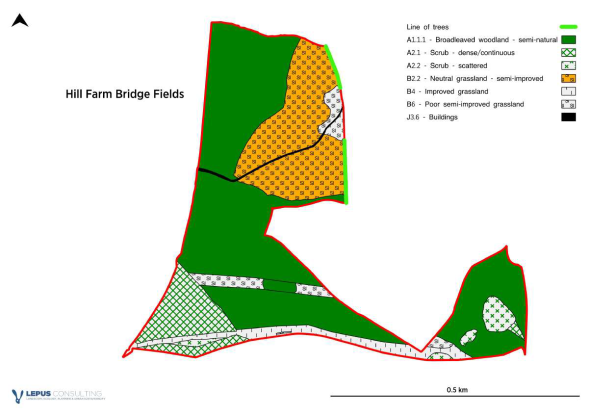
Biodiversity Net Gain (BNG) – Habitat Bank sites (Policy SNE2)
See SLP Evidence base - Sandwell Biodiversity Net Gain Study (September 2023) - for more details
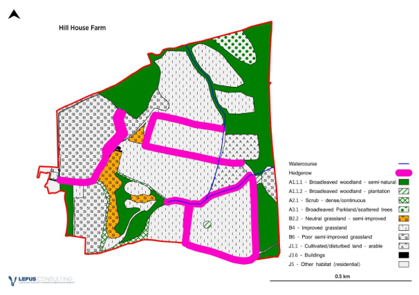
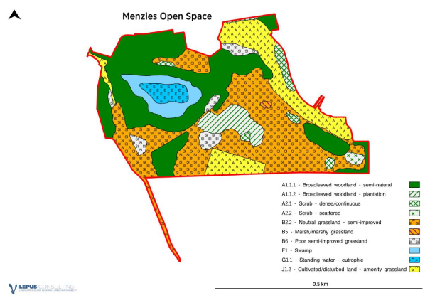
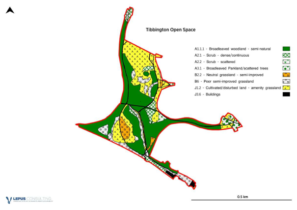
- The following are extracts from the report undertaken for Sandwell Council by Lepus Consulting on potential BNG habitat bank sites within the ownership of the Council. Six sites have been identified in the SLP, to help ensure that biodiversity net gain is retained within the borough as far as possible. Many of Sandwell's new housing and employment allocations lie within heavily urbanised locations where the opportunities for on-site BNG provision are limited.
- The following criteria were used to establish suitable sites for consideration:
- Sites / land wholly-owned by Sandwell Council.
- Exclusion of certain open space typologies from consideration – allotments, cemeteries and churchyards, institutional land (schools, hospitals, sports grounds and reservoirs), outdoor sports facilities and provision for children and young people.
- Exclusion of sites smaller than 10ha.
- Use of the national Biodiversity Net Gain Calculator.
- Where sites under consideration contain public amenity open space, these specific areas were also excluded from consideration for improvement, as their role as accessible open space needs to be retained.
- The following map identifies the list of sites that were ranked by the consultants as being of high and medium value for BNG improvements and identified as potential habitat banks.
(1) Figure 2 - Extract from report - location of high and medium value sites for BNG
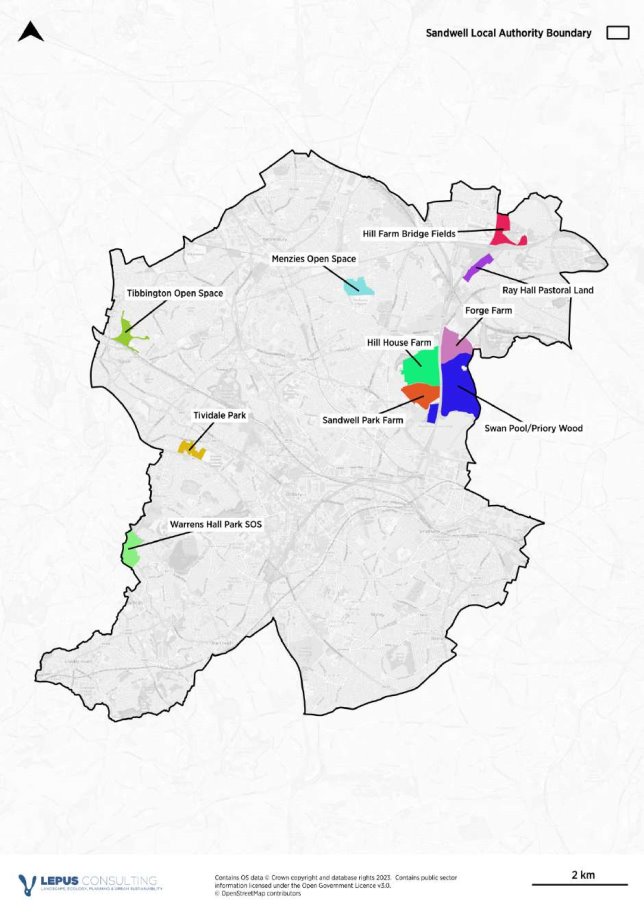
- The six sites included in the SLP (Policy SNE2) are detailed below:
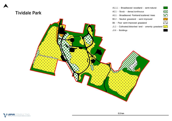
Warrens Hall Park

For instructions on how to use the system and make comments, please see our help guide.