Draft Regulation 18 Sandwell Local Plan
Town Centre Profiles
9.65 The following section sets out a series of appraisals of the main Tier Two town centres in Sandwell. Each profile briefly identifies:
- the background, residential and economic demographic of the centre;
- its perceived strengths and weaknesses; and
- any aspirations, proposals or potential improvements.
9.66 Where appropriate, policies designed to address issues of local concern or importance have been included. These are to be considered alongside the other policies in the SLP that will continue to apply in all parts of Sandwell.
9.67 Any sites identified through the site allocation process that fall within the centre boundaries, and their likely capacities, have been identified.
9.68 References to town centre health checks in the following profiles relate to the Black Country Centres Study 2020: Volume 2 – Health Checks[157] document produced for the Black Country Plan.
9.69 Consultants were commissioned by Sandwell Council in 2020 to develop a Local Cycling and Walking Infrastructure Plan (LCWIP). The Sandwell LCWIP (SCWIP) builds on work already completed at a regional level as part of the West Midlands LCWIP.
9.70 The SCWIP is a Sandwell-wide review of the cycle network and walking routes across Sandwell. It incorporates:
- the four strategically relevant cycling corridors put forward as part of the West Midlands LCWIP;
- the Black Country cycling and walking vision and strategy as well as Cradley Heath railway station as a core walking zone;
- the Cycling Supplementary Planning Document (SPD); and
- the Sandwell Rights of Way Improvement Plan (ROWIP)
as well as identifying gaps in the network.
(1) Bearwood
Background
9.71 The town of Bearwood lies within Abbey Ward.
9.72 The population of Abbey Ward, according to the 2021 Census was 12,186, a rise of 3.7% since 2011. Abbey ward has the third smallest population in the borough. Abbey ward has a smaller proportion of under-16s than average (20.2% compared with 25.1% for the town) but a larger proportion of those aged 25 - 49 (39.3% compared with 37%).
9.73 Abbey Ward has a high proportion of residents in full time employment (39.3%); this is the highest of all Sandwell wards.
Figure 5 - Bearwood Town Centre
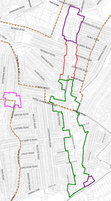
© Crown copyright and database rights 2023, Ordnance Survey Licence No AC0000824500
Boundary Changes
9.74 Boundary changes are suggested for the northern end of Bearwood Road, with the proposed new boundary ending at the junction of Linden Road and Bearwood Road.
9.75 Several reasons inform this decision. Past this point, the retail units on the eastern side of Bearwood Road are set back from the street and cause a break in the high street line that is not reformed. Additionally, the dominance of residential properties on the western side and lack of continuous commercial units in general distinctly separate this area from the rest of the Town Centre.
9.76 It has been suggested that the southern section of the centre should also exclude the units on Hagley Road.
9.77 Further suggestions are for the inclusion of the shops at the junction of Abbey Road and Wigorn Road within the centre boundary. The issue here would be the significant increase in the extent of the town centre boundary. It would also include many non-retail, residential uses at ground floor level. It is therefore proposed that the shops at Abbey Road / Wigorn Road should form a new Local Centre, due to the number of shops and facilities the units offer.
Retail and Town Centre Uses
9.78 Bearwood Town Centre runs along Bearwood Road (c.700m), from Waterloo Road in the north to Hagley Road in the south in a traditional linear high street form. The centre also includes sections of several smaller roads off Bearwood Road such as Three Shires Oak Road and Sandon Road.
9.79 Bearwood contains a retail core that begins south of Belmont Road and continues to the centre's boundary with Hagley Road.
9.80 Bearwood has shown a slight decline in function. It is over-represented in convenience style goods shopping and under-represented in comparison goods. Although Bearwood maintains a good level of national multiples, there has also been a reduction in the number of national multiples outlets since the Health Check study took place in 2020 in terms of service area.
9.81 The service industry has increased in Bearwood since 2009 and as such has improved the evening economy, with the introduction of at least six new pubs, restaurants and cafes.
9.82 According to 2019 data and recent trends, Bearwood has 253 total commercial units, which is 12 fewer than it had in 2009. The number of comparison goods units makes up 22% of the centre's total commercial units, 14% below the UK national average. This under-representation is also reflected in the level of comparison goods floorspace available, which stands at 25.2% of the total commercial floorspace, compared to the national average of 32%. Since 2009, the number of comparison goods units has decreased by 21, with the floorspace decreasing by 1,365m2 (a 28% decrease in the number of units).
9.83 Convenience goods fall slightly below the national average for number of units at 13% compared to 15%. This is contrasted by the floorspace figures which show that convenience goods are overrepresented, making up 18% of the total commercial floorspace compared to the national average of 9%. The small number of convenience goods units and large amount of floorspace is predominantly made up of Aldi, followed by Iceland, The Market, and The Co-operative, which collectively make up 52% of Bearwood's convenience goods floorspace. Aldi alone consists of 1,390m2, stands in a prominent central location and acts as an anchor for the area. There has been a minimal change to the number of units and floorspace of convenience goods since 2009, with four additional units adding 141m2.
9.84 The levels of floorspace for retail services closely align to national averages; in terms of number of units Bearwood is 13% higher at 20% compared to 7%. This shows that there is a high volume of small floorplate retail service units, typical for this type of centre. Leisure services are comparable to national averages in both number of units and floorspace. Service industry representation has increased by eight units and 955m2 since 2009.
9.85 A vacancy rate of 10% (27 units vacant in 2019) is comparable to the national average of 9% and is 3% lower in terms of floorspace. Since 2009 the area of vacant commercial units has decreased from 3,995m2 in 2009 to 3,370m2 in 2019, which reflects the loss of two units.
9.86 The large floorplate convenience stores are located towards the centre of Bearwood Road at the shopping centre, with vacant units appearing to be focussed on the southern end of Bearwood Road. Apart from this there is generally an even distribution of commercial uses around the Town Centre.
9.87 Bearwood includes a reasonable number of national multiples. It also includes two leading supermarket chains and many other retail and service units. This provides the centre with a strong retail and service foundation that helps to support its role as a town centre and the high number of smaller local shops.
9.88 It is noted however that several multiples have left the centre, including HSBC, NatWest, Barclays and Lloyds.
9.89 Bearwood is currently under the limit for HFTs (Policy SDM6).
Facilities provision:
9.90 The centre is supported by a range of community facilities including five churches, two schools and various dental and medical services.
Accessibility
9.91 Due to the centre's location along a linear A-road, it benefits from a high number of bus services, with numerous stops along the length of Bearwood Road and streets such as Three Shires Oak Road and Sandon Road. These stops provide frequent services across the Black Country, including to Birmingham, Dudley, West Bromwich and Oldbury. A small bus interchange is also present on Adkins Lane at the end of Bearwood Road.
9.92 Eight pedestrian crossing points are present across the length of Bearwood Road, providing safe routes for pedestrians across the heavily congested road. The wide pavements feature bollards and barriers, which provide some separation between pedestrians and vehicular traffic; these are specifically focused at junctions and around the Bearwood Shopping Centre.
9.93 There is a high volume of traffic along Bearwood Road.
Accessibility – Provision for cyclists
9.94 The Active Travel Fund-funded route from Thimblemill Baths to Hadley Stadium via High Street and Beaks Road (20 mph) has just been completed. This will connect to SCWIP cycle route 5, Oldbury Town Centre to Bearwood via the Aquatic Centre. As of 2023, cycle route 5 does not have funding.
9.95 Cycle parking provision on Bearwood High Street is limited, with a small number of cycle stands provided outside Aldi and Argos.
9.96 Due to the linear nature of the High Street and pavement widths, it would be difficult to provide additional parking stands on the main road frontages.
Environmental Quality
9.97 The character and period style of Bearwood's buildings vary considerably and range from the late 19th Century to the present day. This creates a contrasting environment that works well in many places, such as with the blending of terracotta buildings around Bearwood Shopping Centre. However, it is less successful in other areas such as the sudden change in building height and style with the unit formerly occupied by The Co-operative (510 - 513 Bearwood Road) and its surroundings.
9.98 Despite it including several attractive buildings and terraces, Bearwood contains various shop frontages in poor condition, which may adversely affect its attractiveness to potential new occupiers or for new development / investments. This includes units for both local retailing and some national multiple outlets. Dated and excessive advertisements also detract from the character and quality of the area.
9.99 There is a clear lack of street furniture and investment in the public realm, such as benches, planting and other landscaping schemes. Though the linear nature of the centre does limit the amount of space for such investment, there are areas that would benefit.
9.100 Heavy vehicular traffic has a clear and obvious negative impact on the environmental quality of the area. Though this is unavoidable given the key network function of the route, investment should be made in making the pedestrian environments as safe and appealing as possible. Areas of additional planting could increase the environmental quality of the centre and break up the visual impacts of large areas of hardstanding.
9.101 Although there are no opportunities within Bearwood town centre itself for BNG sites, there is a possibility within nearby and adjacent parks at Warley Woods and Lightwoods Park.
Historic Environment Allocations
9.102 There is no conservation area in the centre, though both the Bearwood War Memorial outside St Mary's Church, and St Gregory's Church itself are Grade II listed. Additionally, there are several attractive historic buildings in the area, including the Bear Tavern with its clock tower.
SWOT
9.103 The Centres Study Health checks noted the following characteristics for Bearwood:
|
Strengths
|
Weaknesses
|
|
Opportunities
|
Threats
|
Aspirations:
9.104 The repurposing of listed buildings could improve the perception of Cape Hill and it can also make use of attractive architecture to encourage improvement in the vicinity
9.105 Opportunities for funding to spruce up shop front improvement / townscape quality and upgrade general frontages within Bearwood could be sought as they are currently quite poor. Dated and excessive advertisements also detract from the character and quality of the area. This should also be addressed through Policy SDM5.
9.106 There is a clear lack of street furniture and general investment in the public realm such as benches, planting and other landscaping schemes. Though the linear nature of the centre does limit the amount of space for such investment, there are clear areas that would benefit.
9.107 Consideration should be given to improvements designed to mitigate issues related to road traffic, such as poor pedestrian accessibility and high levels of air pollution, which is a dominant feature of the centre.
9.108 Due to lack of opportunity for public spaces within Bearwood, links to Lightwoods Park should be made more obvious
9.109 At the southern end of the town centre, at the junction of Adkins Lane, Bearwood Road, and Hagley Road, there is an area of public space / realm that was redeveloped at some point in the last five years prior to 2023. The redeveloped area features paving and a clock; however, it is let down by having a small number of benches that are awkwardly located. Furthermore, the adjacent roads are heavily congested, noisy and subject to higher levels of pollution through vehicle fumes and emissions. This is an example of an area that could be improved to encourage use of the space. The introduction of green space, a pocket parklet and / or landscaping would be beneficial.
9.110 The following changes would be welcomed, to help make the centre more user-friendly:
- An increase in comparison shops would help to offer a wider range of goods and services.
- If the centre was reduced in size, an effective focal point could be created, with an attempt to try and consolidate core uses of the centre into a smaller area.
(1) Proposals
9.111 The following locations offer opportunities for future improvements and additions to the public realm and character of the area.
|
Ref |
Location |
Indicative Land Use |
|
BE1 |
Land at Bearwood Road opposite Ethel Street (between Merrivale Road and Bearwood Chapel) |
The pedestrian area here is wider than elsewhere along Bearwood Road and there is an element of greenery and planting as well as two benches. Opportunities exist here to create a focal point and to make this area greener by connecting all the planted areas to form one garden area. This will include the removal of the advertisement sign as this adds to the street clutter |
|
BE2 |
The junction of Bearwood Road (A4040) and Three Shires Oak Road (B4182) |
At present, pedestrians must cross at the junction twice in some instances to get to their destination. A diagonal crossing at this junction could aid in permeability of the centre. |
|
BE3 |
Pavements along Bearwood Road |
At various points along Bearwood Road there is vegetation growing from the base of the buildings. Opportunities will be explored to remove such vegetation which will aid in improving the appearance of the centre |
|
BE4 |
Throughout the Town Centre core |
Opportunities will be explored to introduce more cycle parking stands where space allows |
|
BE5 |
Area outside of Aldi |
As the pedestrian area is wider in this location, there is opportunity to add benches |
|
BE 6 |
Adkins Road / Hagley Road – outside Dixons Estate Agents |
The large paved area here looks tired. Opportunities exist here to make the area greener and more inviting through planting and adding benches |
|
Changes to town centre boundary |
See paragraph 9.40 and paragraphs 9.74 to 9.77 |