Sustainability Appraisal of the Sandwell Local Plan 2024-2041
E.1 Introduction
E.1.1 Overview
E.1.1.1 At the previous stage of plan making for the emerging Sandwell Local Plan (SLP), a total of 120 reasonable alternative sites were identified by Sandwell Metropolitan Borough Council (SMBC) and evaluated within the Regulation 18 (II) Sustainability Appraisal (SA) (2023)[1].
E.1.1.2 Following the Regulation 18 (II) Draft Plan consultation in 2023, a further four reasonable alternative sites solely for residential use have been identified by SMBC, whereby 124 reasonable alternative sites have been assessed in the SA process to date. It is also worth noting that a total of four sites assessed at the Regulation 18 (II) stage are no longer reasonable alternatives and have subsequently been removed from assessments at the Regulation 19 stage (see Appendix H).
E.1.1.3 Including the four new sites and accounting for the four removed sites, a total of 120 reasonable alternative sites have therefore been identified, described and evaluated at the Regulation 19 stage of the SLP process. All 120 reasonable alternative sites have been evaluated within this document as part of the Regulation 19 SA, based on the latest information as provided by SMBC, superseding the previous iteration of site assessments as presented in Appendix C of the Regulation 18 (II) SA (2023).
E.1.1.4 This includes 81 sites identified solely for residential use and 28 sites identified solely for employment use. One is identified solely for Gypsy, Traveller and Travelling Showpeople (GTTS) use. Eight sites are identified for mixed-use. The remaining two sites are identified as reasonable alternatives for multiple uses (i.e. the sites could potentially be developed for residential, employment and/or GTTS use).
E.1.1.5 The location of the 120 reasonable alternative sites is shown in Figure E.1.1, and their potential uses are identified in Table E.1.1.
E.1.1.6 Each of the sites appraised within this report have been assessed for likely impacts on each of the 14 SA Objectives, as outlined in the SA Framework (see Appendix B). Likely sustainability impacts have been set out in Tables E.2.1 – E.15.1 within each SA Objective chapter, in accordance with the site assessment methodology set out in Appendix D, as well as the methodology information set out in Chapter 4 of the main SA Report.
E.1.1.7 The pre-mitigation impacts, based on the red line boundary and site proposal information only, help to identify the potential impacts on site if there were no policy or mitigation. The potential mitigating influence of the SLP policies is considered within Appendix G.
E.1.1.8 It should be noted that whilst every effort has been made to predict effects accurately, the sustainability impacts have been assessed at a high level and are reliant upon the current understanding of the baseline. These assessments have been based on information provided by SMBC as well as expert judgement.
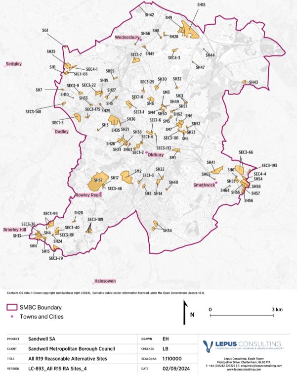
Figure E.1.1: Reasonable alternative sites identified in Sandwell
Table E.1.1: Reasonable alternative sites in Sandwell
|
Site reference |
Site address |
Site use |
Gross Area (ha) |
Net area (ha) (if available) |
Housing capacity |
|
SEC3-181 |
Varney Business Park, Varney Avenue, West Bromwich |
Employment |
0.73 |
N/A |
0 |
|
SEC4-1 |
Zion Street, Tipton |
Employment |
2.43 |
N/A |
0 |
|
SEC3-9 |
Alexandra Ind Est, Locarno Rd/ Alexandra Rd, Tipton |
Employment |
1.87 |
N/A |
0 |
|
SEC3-99 |
Providence Street, Cradley Heath |
Employment |
6.33 |
N/A |
0 |
|
SH1 |
Brown Lion Street |
Housing |
0.46 |
0.46 |
20 |
|
SEC3-113 |
Brandon Way (east side) |
Employment |
0.47 |
N/A |
0 |
|
SEC3-46 |
Droicon Ind Est, Portway Road |
Employment |
0.87 |
N/A |
0 |
|
SEC3-175 |
Coneygre Rd, Burnt Tree, Tipton |
Employment |
1.02 |
N/A |
0 |
|
SEC3-36 |
Silverthorne Lane |
Employment |
1.05 |
N/A |
0 |
|
SEC3-29 |
Site off Richmond St, West Bromwich |
Employment |
1.10 |
N/A |
0 |
|
SEC3-148 |
Castle St, Tipton |
Employment |
1.49 |
N/A |
0 |
|
SH2 |
Land adjacent To Asda Wolverhampton Road, Oldbury |
Housing |
1.50 |
1.5 |
62 |
|
SEC4-4 |
Soho Triangle |
Employment |
1.71 |
N/A |
0 |
|
SEC3-191 |
Oldfield Trading Estate, Cradley Heath |
Employment |
1.76 |
N/A |
0 |
|
SEC4-3 |
70-74 Crankhall Lane |
Employment |
1.78 |
N/A |
0 |
|
SEC3-133 |
Brymill Industrial Estate, Brown Lion St, Tipton |
Employment |
1.78 |
N/A |
0 |
|
SEC3-189 |
Waterfall Lane, Cradley Heath |
Employment |
2.69 |
N/A |
0 |
|
SEC3-22 |
Hale Trading Estate, Tipton |
Employment |
2.73 |
N/A |
0 |
|
SEC3-40 |
Newlyn Road, Cradley Heath |
Employment |
3.40 |
N/A |
0 |
|
SEC1-4 |
Severn Trent land off Roway Lane |
Employment |
3.65 |
N/A |
0 |
|
SH3 |
88/90 Dudley Rd West |
Housing |
0.36 |
N/A |
12 |
|
SH4 |
Lower High Street (Station Hotel & Dunns Site) |
Housing |
0.28 |
0.28 |
20 |
|
SH5 |
Mill Street, Great Bridge |
Housing |
0.88 |
0.88 |
30 |
|
SH6 |
Swan Lane, North of A41, West Bromwich |
Housing |
3.78 |
2.42 |
147 |
|
SH7 |
The Boat Gauging House & Adjoining Land, Factory Road, Tipton |
Housing |
0.57 |
0.57 |
50 |
|
SH8 |
Alma Street, Wednesbury |
Housing |
0.52 |
0.52 |
19 |
|
SH9 |
The Phoenix Collegiate, Friar Park Road, Wednesbury |
Housing |
4.80 |
2.84 |
84 |
|
SH62 |
Star and Garter, 252 Duchess Parade, West Bromwich |
Housing |
0.05 |
0.05 |
60 |
|
SH10 |
Tipton Conservative and Unionist Club, 64 Union St, Tipton |
Housing |
0.19 |
0.19 |
14 |
|
SH11 |
Sandwell District & General Hospital |
Housing |
0.82 |
0.82 |
121 |
|
35 |
Intersection House, 110 Birmingham Road, West Brom |
Housing |
0.80 |
N/A |
136 |
|
36 |
Vacant Land Off Friardale Close, School Road, Carrington Road, Wednesbury |
Housing |
0.76 |
N/A |
30 |
|
38 |
173 Rolfe Street, Smethwick |
Housing |
0.40 |
N/A |
12 |
|
40 |
Metro House 410-416 High Street West Bromwich |
Housing |
0.38 |
N/A |
34 |
|
42 |
Land between St Pauls Road & Tollhouse Way |
Housing |
0.33 |
N/A |
11 |
|
43 |
Land adjacent Compton Grange, Whiteall Road, St Annes Road, Cradley Heath |
Housing |
0.30 |
N/A |
15 |
|
44 |
Crosswells Road, Langley |
Housing |
0.29 |
N/A |
12 |
|
45 |
164 Birmingham Road, West Bromwich |
Housing |
0.22 |
N/A |
16 |
|
46 |
5 Lombard Street West Bromwich |
Housing |
0.16 |
N/A |
44 |
|
SH13 |
Silverthorne Lane/ Forge Lane Cradley Heath |
Housing |
2.41 |
1.81 |
81 |
|
SH14 |
Langley Maltings, Western Road, Langley |
Housing |
2.72 |
2.04 |
95 |
|
SH15 |
Macarthur Road Industrial Estate, Cradley Heath |
Housing |
0.30 |
0.3 |
10 |
|
SEC3-79 |
Land off Overend Road, Cradley Heath Business Park |
Employment |
3.00 |
N/A |
0 |
|
SH16 |
Cradley Heath Factory Centre, Woods Lane, Cradley Heath |
Housing |
5.57 |
4.36 |
160 |
|
SH17 |
Land adj to Droicon Estate, Portway Road, Rowley Regis |
Housing |
0.70 |
0.7 |
28 |
|
SH18 |
STW/SMBC Land, Friar Park Road, Wednesbury |
Housing |
26.3 |
25.75 |
630 |
|
SEC3-193 |
Perrott Street/ Kitchener Street, Black Patch, Smethwick |
Employment |
1.39 |
N/A |
49 |
|
SH19 |
Land at Horseley Heath, Alexandra Road, and Lower Church Lane, Tipton |
Housing |
2.26 |
1.9 |
60 |
|
SH20 |
Elbow Street, Old Hill |
Housing |
0.77 |
0.77 |
25 |
|
SH21 |
Dudley Road East/Brades Road |
Housing |
2.65 |
1.99 |
106 |
|
SH22 |
Tatbank Road, Oldbury |
Housing |
1.15 |
1.15 |
40 |
|
SH23 |
28-64 High Street, West Bromwich |
Housing |
0.60 |
0.6 |
58 |
|
63 |
Site between Dudley St & Victoria St, Wednesbury |
Housing/employment |
1.18 |
N/A |
41 |
|
SH24 |
Cokeland Place / Graingers Lane, Cradley Heath |
Housing |
0.36 |
0.36 |
13 |
|
SH25 |
Bradleys Lane / High Street, Tipton |
Housing |
5.60 |
4.2 |
230 |
|
SH26 |
Lower City Road, Oldbury |
Housing |
1.83 |
1.83 |
63 |
|
SH27 |
Site surrounding former Post office and Telephone exchange, Horseley Heath, Tipton |
Housing |
1.16 |
1.16 |
42 |
|
SH28 |
Friar Street, Wednesbury |
Housing |
1.01 |
1.01 |
38 |
|
SH29 |
Used Car Sales site on corner of Lower Church Lane and Horseley Heath, Tipton |
Housing |
0.56 |
0.56 |
20 |
|
71 |
Grafton Lodge, Grafton Road, Oldbury |
Housing |
0.53 |
N/A |
19 |
|
74 |
The Corner of Great Bridge & Richmond Street South |
Housing/Employment |
0.23 |
N/A |
8 |
|
SH30 |
Land to east of Black Lake, West Bromwich |
Housing |
2.45 |
1.83 |
86 |
|
SH31 |
Summerton Road, Oldbury |
Housing |
0.89 |
0.89 |
32 |
|
SH32 |
Bank Street (West), Hateley Heath |
Housing |
0.85 |
0.85 |
43 |
|
SH33 |
Wellington Road, Tipton |
Housing |
0.91 |
0.91 |
31 |
|
SH34 |
Brandhall Golf Course |
Housing |
5.18 |
3.88 |
190 |
|
SH35 |
Rattlechain Site Land to the north of Temple Way, Tividale |
Housing |
14.80 |
14.8 |
518 |
|
SH36 |
Land between Addington Way and River Tame, Temple Way |
Housing |
0.90 |
0.9 |
32 |
|
SH37 |
Edwin Richards Quarry, Portway Road, Rowley Regis |
Housing |
52.00 |
15 |
526 |
|
SEC3-66 |
Soho Foundry |
Employment |
11.75 |
N/A |
0 |
|
SH38 |
Brades Road, Oldbury |
Housing |
1.14 |
1.14 |
54 |
|
SM1 |
Chances Glassworks |
Mixed-use |
0.64 |
N/A |
276 |
|
SH40 |
Langley Swimming Centre, Vicarage Road, Oldbury |
Housing |
0.49 |
0.49 |
20 |
|
SH41 |
North Smethwick Canalside |
Housing |
8.70 |
6.5 |
400 |
|
SH42 |
Forge Put, junction Franchise Street and Beebee Road |
Housing |
0.14 |
0.14 |
10 |
|
SEC1-3 |
Land at Birchley Island, Junction 2 of M5, Oldbury |
Employment |
1.12 |
N/A |
0 |
|
110 |
Bloomfield Road Amenity Space |
Housing |
0.38 |
N/A |
15 |
|
118 |
Constance Avenue Open Space |
Housing |
1.60 |
N/A |
64 |
|
120 |
Darbys Hill Open Space |
Housing |
3.80 |
N/A |
114 |
|
132 |
Lily Street Open Space |
Housing |
3.80 |
N/A |
114 |
|
137 |
Poppy Drive Open Space |
Housing |
0.80 |
N/A |
32 |
|
140 |
Timbertree Crescent Open Space |
Housing |
0.50 |
N/A |
20 |
|
142 |
Wylde Crescent Open Space |
Housing |
0.50 |
N/A |
20 |
|
SH43 |
Land of Tanhouse Avenue, Great Barr |
Housing |
1.66 |
1.15 |
46 |
|
SH44 |
Wyndmill crescent, West Bromwich |
Housing |
0.19 |
0.19 |
11 |
|
SH47 |
Site Of Former Stone Cross Neighbourhood Office |
Housing |
0.32 |
0.32 |
14 |
|
SM3 |
Evans Halshaw car showroom, Carters Green |
Mixed-use |
0.89 |
N/A |
140 |
|
SH49 |
St Johns St, Carters Green |
Housing |
0.82 |
0.82 |
33 |
|
SM4 |
Army Reserve, Carters Green |
Mixed-use |
1.17 |
N/A |
63 |
|
SH50 |
Tentec, Guns Lane |
Housing |
0.60 |
0.6 |
129 |
|
SH51 |
Providence Place/ Bratt St |
Housing |
0.74 |
0.4 |
70 |
|
SM5 |
Cultural Quarter, West Bromwich |
Mixed-use |
1.09 |
N/A |
52 |
|
SM6 |
Queens Square Living, West Bromwich |
Mixed-use |
3.06 |
N/A |
396 |
|
SM7 |
West Bromwich Central |
Mixed-use |
4.53 |
N/A |
343 |
|
SH52 |
Overend Street, West Bromwich |
Housing |
0.71 |
0.71 |
70 |
|
SM8 |
George Street Living |
Mixed-use |
2.36 |
N/A |
327 |
|
SH53 |
Grove Lane/ Cranford Street/ London Street |
Housing |
1.23 |
1.23 |
108 |
|
SH54 |
Cranford Street / Heath Street / Canal |
Housing |
5.00 |
2.88 |
115 |
|
SH55 |
Cape Arm Cranford Street |
Housing |
2.13 |
2.13 |
170 |
|
SH56 |
Moilliett Street Park - Grove Lane masterplan |
Housing |
0.77 |
0.77 |
31 |
|
SH57 |
Grove Street / MMUH / School - Grove Lane MP |
Housing |
2.18 |
0.59 |
85 |
|
SH58 |
Abberley Street Grove Lane Master Plan |
Housing |
2.48 |
2.48 |
140 |
|
SG1 |
Extension to Caravan Site, Brierley Lane, Bilston |
G&T |
0.73 |
0.73 |
10 |
|
188 |
Land Between No.32 And George Betts School, West End Avenue, Smethwick |
Housing |
0.32 |
N/A |
11 |
|
189 |
Hawes Lane, Rowley Regis |
Housing |
0.56 |
N/A |
15 |
|
SH59 |
Beever Road, Great Bridge |
Housing |
1.01 |
1.01 |
18 |
|
191 |
Former Sunlight Laundry, Stanhope Road, Smethwick |
Housing |
0.73 |
N/A |
33 |
|
SH61 |
Thandi Coach Station, Alma Street, Smethwick |
Housing |
0.71 |
0.71 |
58 |
|
SEC1-1 |
Whitehall Road, Tipton |
Employment |
5.30 |
N/A |
0 |
|
SEC1-8 |
Legacy 43, Ryder Street, West Bromwich |
Employment |
0.88 |
N/A |
0 |
|
SEC1-5 |
Land at Coneygre, Newcomen Drive, Tipton |
Employment |
7.22 |
N/A |
0 |
|
SEC1-6 |
Land off Brandon Way, West Bromwich |
Employment |
3.07 |
N/A |
0 |
|
SEC1-2 |
British Gas, Land off Dudley Road, Oldbury |
Employment |
1.05 |
N/A |
0 |
|
SEC1-7 |
Site off Bilport Lane, Wednesbury |
Employment |
5.29 |
N/A |
0 |
|
SM2 |
Lion Farm Playing Fields, Oldbury |
Mixed-use |
20.89 |
N/A |
200 |
|
SH45 |
Site of 30-144 Mounts Road, Wednesbury |
Housing |
1.07 |
1.07 |
22 |
|
SH63 |
192-200 Dudley Road, Oldbury |
Housing |
0.58 |
N/A |
24 |
|
SH65 |
Smethwick Police Station, Piddock Road, Smethwick |
Housing |
0.22 |
N/A |
10 |
|
SH64 |
Windmill House, Windmill Lane, Smethwick |
Housing |
0.21 |
N/A |
10 |
|
SH66 |
Wednesbury Police Station, Albert Street, Wednesbury |
Housing |
0.33 |
N/A |
15 |
E.2 SA Objective 1: Cultural Heritage
E.2.1 Grade I Listed Buildings
E.2.1.1 There are two Grade I Listed Buildings in Sandwell, 'West Bromwich Manor House' and 'Galton Bridge', and several others nearby in surrounding authority areas. Although Site SEC4-3 lies in close proximity (approximately 180m) to 'West Bromwich Manor House', the previously developed nature of the site means that adverse effects on the setting of the building are considered unlikely. The proposed development at all 125 reasonable alternative sites will be unlikely to significantly impact Grade I Listed Buildings, therefore a negligible impact has been identified across these sites.
E.2.2 Grade II* Listed Buildings
E.2.2.1 There are eight Grade II* Listed Buildings within Sandwell, mostly concentrated in and around the Smethwick area in the south east of the borough. Site SEC3-66 coincides with 'Soho Foundry Former Boulton and Watt Foundry Pattern Stores and Erecting Shops'. The proposed development at this site could potentially lead to a direct major negative impact on the Grade II* Listed Building.
E.2.2.2 Site SH41 is located adjacent to 'Engine Arm Aqueduct, Birmingham Canal Wolverhampton Level'. The proposed development at this site could potentially have a minor negative impact on the setting of this Listed Building.
E.2.2.3 However, both Sites SEC3-66 and SH41 contain some existing development and so it is acknowledged that there may also be opportunities to improve the historic setting of the area through regeneration of degraded industrial buildings currently on site.
E.2.2.4 The proposed development at all other reasonable alternative sites will be unlikely to significantly impact any Grade II* Listed Buildings, primarily due to the sites being separated from listed buildings by existing built form. Therefore, a negligible impact has been identified across these sites.
E.2.3 Grade II Listed Buildings
E.2.3.1 There are many Grade II Listed Buildings throughout Sandwell, generally clustered within the built-up areas, along the canal network, and particularly within West Bromwich and Oldbury town centres. There are five reasonable alternative sites that coincide with a Grade II Listed Building (Sites SH7, SH14, SEC3-66, SM1 and SM5). Site SEC3-66 coincides with 'Gateway and Gates', 'Office Row', and 'Gatehouse and adjoining Office' and is adjacent to 'Towpath Bridge at Soho Foundry'. Site SM1 coincides with 'Double Range of Warehouses immediately west of Hartley Bridge, Chance's glassworks', 'Warehouse between Hartley Bridge and canal bridge, chance's glassworks', and 'Two warehouses, immediately east of canal bridge, chance's glassworks', and is adjacent or close to several others. Site SM5 coincides with 'Town Hall', 'Pair of K6 Telephone Kiosks outside Library and Town Hall', 'Central Public Library', and 'Law Courts'. The proposed development at these five sites could potentially result in direct major negative impacts on these listed buildings, without careful consideration of site layout and design.
E.2.3.2 Some six sites are located adjacent to Grade II Listed Buildings (Sites SEC4-1, SEC4-4, SH41, SM6, SM7 and SEC1-1). A further nine sites could potentially have an adverse impact on the setting of various listed buildings, due to the nature and scale of the proposed development and the proximity of listed buildings. For example, Site SEC4-4 is located adjacent to the Grade II Listed Building 'Towpath Bridge, Birmingham Canal Birmingham Level'. The proposed development at these 15 sites could potentially result in a minor negative impact on the setting of one or more Grade II Listed Buildings.
E.2.4 Conservation Area
E.2.4.1 Sandwell contains nine Conservation Areas (CA), the majority of which cover sections of the urban area, as well as portions of the canal network, historic open spaces and nature reserves. There are nine reasonable alternative sites that are located within a CA, including Sites SH10 and SH7 which lie wholly within 'Factory Locks, Tipton' CA, Sites SH50 and SM5 which lie partially within 'High Street West Bromwich' CA, Sites 38, SM1, SH41, and SH54 which lie wholly or partially within 'Smethwick Galton Valley' CA, and SH65 which lies wholly within 'Smethwick High Street and Crocketts Lane' CA. There are a further eight sites which are adjacent or in close proximity to a CA. The proposed development at these 17 sites could potentially result in a minor negative impact on the character or setting of these CAs. The proposed development at the remaining sites will be unlikely to have a significant impact on the setting of any CA.
E.2.5 Scheduled Monument
E.2.5.1 There are eight Scheduled Monuments (SMs) within Sandwell, generally covering previously developed areas in relation to Birmingham Canal or areas with industrial history. Some three sites coincide with a SM. Site SEC3-66 wholly encompasses the 'remains of the Boulton and Watt Soho Foundry and mint, Birmingham Canal, Smethwick' SM, Site SM1 almost wholly coincides with 'Chances Glassworks' SM, and Site SH41 partially coincides with 'Engine Arm Aqueduct' SM and wholly encompasses the small SM 'Smethwick Engine House'. The proposed development at these three sites could potentially have a direct adverse effect on these SMs, resulting in a major negative impact on cultural heritage. However, these sites contain some existing development, so it is acknowledged that there may also be opportunities to improve the historic setting of the area and associated SMs through regeneration of degraded industrial buildings currently on site.
E.2.5.2 All other reasonable alternative sites are not located in close proximity to any SMs, and as such, the proposed development at these sites will be unlikely to significantly impact the setting of any of these SMs.
E.2.6 Registered Park and Garden
E.2.6.1 Five Registered Parks and Gardens (RPGs) can be found within Sandwell: 'Brunswick Park', 'Victoria Park (Tipton)', 'Dartmouth Park', 'Warley Park' and a small proportion of 'Great Barr Hall'. Site SEC1-5 is located approximately 200m from 'Victoria Park (Tipton)' RPG. Although there is some intervening built form separating Site SEC1-5 from the RPG, the site comprises a large area of undeveloped land. The proposed development at the site could potentially result in a minor negative impact on the setting of the RPG. The remaining sites are deemed unlikely to have a significant impact on the setting of any RPG due to the previously developed nature of the sites and/or presence of intervening development.
E.2.7 Archaeological Priority Area
E.2.7.1 Archaeological Priority Areas (APAs) have been identified throughout Sandwell's urban and undeveloped areas. Four sites coincide with APAs (Sites 189, SH33, SH26, and SH31) and a further eight sites are located adjacent to APAs. The proposed development at these 12 sites could potentially alter the setting of these APAs, and as a result have a minor negative impact on the historic environment. The remaining sites are not located in close proximity to APAs, and therefore, will be likely to have a negligible impact on the setting of APAs.
E.2.8 Historic Landscape Characterisation
E.2.8.1 The Black Country Historic Landscape Characterisation (HLC) Study[2] has identified a range of Historic Environment Area Designations within the Black Country, covering a large proportion of Sandwell's parkland and Green Belt as well as a number of features within the urban areas. Nine of the reasonable alternative sites (SEC3-99, SH7, 43, SH14, SH16, SH33, SH34, SEC3-66 and SM1) coincide wholly or partially within an area of High Historic Landscape Value (HHLV) or High Historic Townscape Value (HHTV). This includes Site SH34 which coincides with 'Brandhall Ridge and Furrow' HHLV, which is a rare feature in Sandwell. No sites coincide with any Designed Landscapes of High Historic Value. Development within areas of HHLV/HHTV may lead to the loss of surviving archaeological features of interest and their visual or functional links to Sandwell's past. Therefore, the proposed development at these nine sites could potentially result in a minor negative impact on the surrounding historic environment. The remaining sites do not coincide with any identified areas of high historic value, and therefore, will be expected to have a negligible impact on the local historic environment.
Table E.2.1: Sites impact matrix for SA Objective 1 – Cultural heritage
|
Site Reference |
Site Use |
Grade I Listed Building |
Grade II* Listed Building |
Grade II Listed Building |
Conservation Area |
Scheduled Monument |
Registered Park and Garden |
Archaeological Priority Area |
Historic Landscape Characterisation |
|
SEC3-181 |
EMP |
0 |
0 |
0 |
0 |
0 |
0 |
0 |
0 |
|
SEC4-1 |
EMP |
0 |
0 |
- |
0 |
0 |
0 |
0 |
0 |
|
SEC3-9 |
EMP |
0 |
0 |
0 |
0 |
0 |
0 |
0 |
0 |
|
SEC3-99 |
EMP |
0 |
0 |
0 |
0 |
0 |
0 |
0 |
- |
|
SH1 |
HSG |
0 |
0 |
0 |
0 |
0 |
0 |
0 |
0 |
|
SEC3-113 |
EMP |
0 |
0 |
0 |
0 |
0 |
0 |
0 |
0 |
|
SEC3-46 |
EMP |
0 |
0 |
0 |
0 |
0 |
0 |
0 |
0 |
|
SEC3-175 |
EMP |
0 |
0 |
0 |
0 |
0 |
0 |
- |
0 |
|
SEC3-36 |
EMP |
0 |
0 |
0 |
0 |
0 |
0 |
0 |
0 |
|
SEC3-29 |
EMP |
0 |
0 |
0 |
0 |
0 |
0 |
0 |
0 |
|
SEC3-148 |
EMP |
0 |
0 |
0 |
- |
0 |
0 |
- |
0 |
|
SH2 |
HSG |
0 |
0 |
0 |
0 |
0 |
0 |
0 |
0 |
|
SEC4-4 |
EMP |
0 |
0 |
- |
- |
0 |
0 |
0 |
0 |
|
SEC3-191 |
EMP |
0 |
0 |
0 |
0 |
0 |
0 |
0 |
0 |
|
SEC4-3 |
EMP |
0 |
0 |
0 |
0 |
0 |
0 |
0 |
0 |
|
SEC3-133 |
EMP |
0 |
0 |
0 |
0 |
0 |
0 |
0 |
0 |
|
SEC3-189 |
EMP |
0 |
0 |
0 |
0 |
0 |
0 |
0 |
0 |
|
SEC3-22 |
EMP |
0 |
0 |
0 |
0 |
0 |
0 |
0 |
0 |
|
SEC3-40 |
EMP |
0 |
0 |
0 |
0 |
0 |
0 |
0 |
0 |
|
SEC1-4 |
EMP |
0 |
0 |
0 |
0 |
0 |
0 |
0 |
0 |
|
SH3 |
HSG |
0 |
0 |
0 |
0 |
0 |
0 |
- |
0 |
|
SH4 |
HSG |
0 |
0 |
0 |
0 |
0 |
0 |
0 |
0 |
|
SH5 |
HSG |
0 |
0 |
0 |
0 |
0 |
0 |
- |
0 |
|
SH6 |
HSG |
0 |
0 |
0 |
0 |
0 |
0 |
0 |
0 |
|
SH7 |
HSG |
0 |
0 |
-- |
- |
0 |
0 |
- |
- |
|
SH8 |
HSG |
0 |
0 |
0 |
0 |
0 |
0 |
0 |
0 |
|
SH9 |
HSG |
0 |
0 |
0 |
0 |
0 |
0 |
0 |
0 |
|
SH62 |
HSG |
0 |
0 |
- |
0 |
0 |
0 |
0 |
0 |
|
SH10 |
HSG |
0 |
0 |
0 |
- |
0 |
0 |
0 |
0 |
|
SH11 |
HSG |
0 |
0 |
0 |
0 |
0 |
0 |
0 |
0 |
|
35 |
HSG |
0 |
0 |
0 |
0 |
0 |
0 |
0 |
0 |
|
36 |
HSG |
0 |
0 |
0 |
0 |
0 |
0 |
0 |
0 |
|
38 |
HSG |
0 |
0 |
0 |
0 |
0 |
0 |
0 |
0 |
|
40 |
HSG |
0 |
0 |
0 |
0 |
0 |
0 |
0 |
0 |
|
42 |
HSG |
0 |
0 |
0 |
- |
0 |
0 |
0 |
0 |
|
43 |
HSG |
0 |
0 |
0 |
0 |
0 |
0 |
0 |
- |
|
44 |
HSG |
0 |
0 |
0 |
0 |
0 |
0 |
0 |
0 |
|
45 |
HSG |
0 |
0 |
0 |
0 |
0 |
0 |
0 |
0 |
|
46 |
HSG |
0 |
0 |
0 |
- |
0 |
0 |
0 |
0 |
|
SH13 |
HSG |
0 |
0 |
0 |
0 |
0 |
0 |
0 |
0 |
|
SH14 |
HSG |
0 |
0 |
-- |
0 |
0 |
0 |
0 |
- |
|
SH15 |
HSG |
0 |
0 |
0 |
0 |
0 |
0 |
0 |
0 |
|
SEC3-79 |
EMP |
0 |
0 |
0 |
0 |
0 |
0 |
0 |
0 |
|
SH16 |
HSG |
0 |
0 |
0 |
0 |
0 |
0 |
0 |
- |
|
SH17 |
HSG |
0 |
0 |
0 |
0 |
0 |
0 |
0 |
0 |
|
SH18 |
HSG |
0 |
0 |
0 |
0 |
0 |
0 |
0 |
0 |
|
SEC3-193 |
EMP |
0 |
0 |
- |
0 |
0 |
0 |
0 |
0 |
|
SH19 |
HSG |
0 |
0 |
0 |
0 |
0 |
0 |
0 |
0 |
|
SH20 |
HSG |
0 |
0 |
0 |
0 |
0 |
0 |
0 |
0 |
|
SH21 |
HSG |
0 |
0 |
0 |
0 |
0 |
0 |
- |
0 |
|
SH22 |
HSG |
0 |
0 |
0 |
0 |
0 |
0 |
0 |
0 |
|
SH23 |
HSG |
0 |
0 |
0 |
0 |
0 |
0 |
0 |
0 |
|
63 |
HSG/EMP |
0 |
0 |
0 |
0 |
0 |
0 |
0 |
0 |
|
SH24 |
HSG |
0 |
0 |
0 |
0 |
0 |
0 |
0 |
0 |
|
SH25 |
HSG |
0 |
0 |
0 |
0 |
0 |
0 |
0 |
0 |
|
SH26 |
HSG |
0 |
0 |
- |
0 |
0 |
0 |
- |
0 |
|
SH27 |
HSG |
0 |
0 |
0 |
0 |
0 |
0 |
0 |
0 |
|
SH28 |
HSG |
0 |
0 |
0 |
0 |
0 |
0 |
0 |
0 |
|
SH29 |
HSG |
0 |
0 |
0 |
0 |
0 |
0 |
0 |
0 |
|
71 |
HSG |
0 |
0 |
0 |
0 |
0 |
0 |
0 |
0 |
|
74 |
HSG/EMP |
0 |
0 |
0 |
0 |
0 |
0 |
0 |
0 |
|
SH30 |
HSG |
0 |
0 |
0 |
0 |
0 |
0 |
0 |
0 |
|
SH31 |
HSG |
0 |
0 |
0 |
0 |
0 |
0 |
- |
0 |
|
SH32 |
HSG |
0 |
0 |
0 |
0 |
0 |
0 |
0 |
0 |
|
SH33 |
HSG |
0 |
0 |
0 |
0 |
0 |
0 |
- |
- |
|
SH34 |
HSG |
0 |
0 |
0 |
0 |
0 |
0 |
0 |
- |
|
SH35 |
HSG |
0 |
0 |
- |
0 |
0 |
0 |
0 |
0 |
|
SH36 |
HSG |
0 |
0 |
0 |
0 |
0 |
0 |
0 |
0 |
|
SH37 |
HSG |
0 |
0 |
- |
- |
0 |
0 |
0 |
0 |
|
SEC3-66 |
EMP |
0 |
-- |
-- |
- |
-- |
0 |
0 |
- |
|
SH38 |
HSG |
0 |
0 |
0 |
0 |
0 |
0 |
- |
0 |
|
SM1 |
Mixed-use |
0 |
0 |
-- |
- |
-- |
0 |
0 |
- |
|
SH40 |
HSG |
0 |
0 |
0 |
0 |
0 |
0 |
0 |
0 |
|
SH41 |
HSG |
0 |
- |
- |
- |
-- |
0 |
0 |
0 |
|
SH42 |
HSG |
0 |
0 |
0 |
0 |
0 |
0 |
0 |
0 |
|
SEC1-3 |
EMP |
0 |
0 |
0 |
0 |
0 |
0 |
0 |
0 |
|
110 |
HSG |
0 |
0 |
0 |
0 |
0 |
0 |
0 |
0 |
|
118 |
HSG |
0 |
0 |
0 |
0 |
0 |
0 |
0 |
0 |
|
120 |
HSG |
0 |
0 |
0 |
0 |
0 |
0 |
0 |
0 |
|
132 |
HSG |
0 |
0 |
0 |
0 |
0 |
0 |
0 |
0 |
|
137 |
HSG |
0 |
0 |
0 |
0 |
0 |
0 |
0 |
0 |
|
140 |
HSG |
0 |
0 |
0 |
0 |
0 |
0 |
0 |
0 |
|
142 |
HSG |
0 |
0 |
0 |
0 |
0 |
0 |
0 |
0 |
|
SH43 |
HSG |
0 |
0 |
0 |
0 |
0 |
0 |
0 |
0 |
|
SH44 |
HSG |
0 |
0 |
0 |
0 |
0 |
0 |
0 |
0 |
|
SH47 |
HSG |
0 |
0 |
0 |
0 |
0 |
0 |
0 |
0 |
|
SM3 |
Mixed-use |
0 |
0 |
- |
0 |
0 |
0 |
0 |
0 |
|
SH49 |
HSG |
0 |
0 |
0 |
0 |
0 |
0 |
0 |
0 |
|
SM4 |
Mixed-use |
0 |
0 |
0 |
0 |
0 |
0 |
0 |
0 |
|
SH50 |
HSG |
0 |
0 |
0 |
0 |
0 |
0 |
0 |
0 |
|
SH51 |
HSG |
0 |
0 |
- |
- |
0 |
0 |
0 |
0 |
|
SM5 |
Mixed-use |
0 |
0 |
-- |
- |
0 |
0 |
0 |
0 |
|
SM6 |
Mixed-use |
0 |
0 |
- |
0 |
0 |
0 |
0 |
0 |
|
SM7 |
Mixed-use |
0 |
0 |
- |
0 |
0 |
0 |
0 |
0 |
|
SH52 |
HSG |
0 |
0 |
0 |
0 |
0 |
0 |
0 |
0 |
|
SM8 |
Mixed-use |
0 |
0 |
0 |
0 |
0 |
0 |
0 |
0 |
|
SH53 |
HSG |
0 |
0 |
0 |
0 |
0 |
0 |
0 |
0 |
|
SH54 |
HSG |
0 |
0 |
0 |
- |
0 |
0 |
0 |
0 |
|
SH55 |
HSG |
0 |
0 |
0 |
- |
0 |
0 |
0 |
0 |
|
SH56 |
HSG |
0 |
0 |
0 |
0 |
0 |
0 |
0 |
0 |
|
SH57 |
HSG |
0 |
0 |
0 |
0 |
0 |
0 |
0 |
0 |
|
SH58 |
HSG |
0 |
0 |
0 |
- |
0 |
0 |
0 |
0 |
|
SG1 |
GTTS |
0 |
0 |
0 |
0 |
0 |
0 |
0 |
0 |
|
188 |
HSG |
0 |
0 |
0 |
0 |
0 |
0 |
0 |
0 |
|
189 |
HSG |
0 |
0 |
0 |
0 |
0 |
0 |
- |
0 |
|
SH59 |
HSG |
0 |
0 |
0 |
0 |
0 |
0 |
0 |
0 |
|
191 |
HSG |
0 |
0 |
0 |
0 |
0 |
0 |
0 |
0 |
|
SH61 |
HSG |
0 |
0 |
0 |
0 |
0 |
0 |
0 |
0 |
|
SEC1-1 |
EMP |
0 |
0 |
- |
0 |
0 |
0 |
0 |
0 |
|
SEC1-8 |
EMP |
0 |
0 |
0 |
0 |
0 |
0 |
0 |
0 |
|
SEC1-5 |
EMP |
0 |
0 |
0 |
0 |
0 |
- |
0 |
0 |
|
SEC1-6 |
EMP |
0 |
0 |
0 |
0 |
0 |
0 |
- |
0 |
|
SEC1-2 |
EMP |
0 |
0 |
0 |
0 |
0 |
0 |
0 |
0 |
|
SEC1-7 |
EMP |
0 |
0 |
0 |
0 |
0 |
0 |
0 |
0 |
|
SM2 |
Mixed-use |
0 |
0 |
0 |
0 |
0 |
0 |
0 |
0 |
|
SH45 |
HSG |
0 |
0 |
0 |
0 |
0 |
0 |
0 |
0 |
|
SH63 |
HSG |
0 |
0 |
0 |
0 |
0 |
0 |
0 |
0 |
|
SH65 |
HSG |
0 |
0 |
- |
- |
0 |
0 |
0 |
0 |
|
SH64 |
HSG |
0 |
0 |
0 |
0 |
0 |
0 |
0 |
0 |
|
SH66 |
HSG |
0 |
0 |
- |
0 |
0 |
0 |
0 |
0 |
E.3 SA Objective 2: Landscape
E.3.1 Landscape Sensitivity
E.3.1.1 The Black Country Landscape Sensitivity Assessment[3] identified the extent to which the character and quality of Black Country Green Belt land is susceptible to change as a result of future development. In Sandwell, Green Belt is restricted to the north east of the borough, at Sandwell Valley. Of the 120 reasonable alternative sites identified for the SLP at the Regulation 19 stage, 119 sites lie outside of the Green Belt, and as such outside of the Landscape Sensitivity Assessment study area. Therefore, the potential effects of each site on sensitive landscapes are uncertain.
E.3.1.2 Site 137 is partially located within the Green Belt to the south of the site, within an area identified as being of 'low' landscape sensitivity. Therefore, the proposed development at this site will be expected to result in a negligible impact on sensitive landscapes.
E.3.1.3 Information relating to the historic environment which has strong links with landscapes/townscapes in Sandwell, including the Historic Landscape Characterisation and associated designations, has been assessed under SA Objective 1 (Cultural Heritage) (see Chapter E.2).
Table E.3.1: Sites impact matrix for SA Objective 2 – Landscape
|
Site Reference |
Site Use |
Landscape Sensitivity |
|
SEC3-181 |
EMP |
+/- |
|
SEC4-1 |
EMP |
+/- |
|
SEC3-9 |
EMP |
+/- |
|
SEC3-99 |
EMP |
+/- |
|
SH1 |
HSG |
+/- |
|
SEC3-113 |
EMP |
+/- |
|
SEC3-46 |
EMP |
+/- |
|
SEC3-175 |
EMP |
+/- |
|
SEC3-36 |
EMP |
+/- |
|
SEC3-29 |
EMP |
+/- |
|
SEC3-148 |
EMP |
+/- |
|
SH2 |
HSG |
+/- |
|
SEC4-4 |
EMP |
+/- |
|
SEC3-191 |
EMP |
+/- |
|
SEC4-3 |
EMP |
+/- |
|
SEC3-133 |
EMP |
+/- |
|
SEC3-189 |
EMP |
+/- |
|
SEC3-22 |
EMP |
+/- |
|
SEC3-40 |
EMP |
+/- |
|
SEC1-4 |
EMP |
+/- |
|
SH3 |
HSG |
+/- |
|
SH4 |
HSG |
+/- |
|
SH5 |
HSG |
+/- |
|
SH6 |
HSG |
+/- |
|
SH7 |
HSG |
+/- |
|
SH8 |
HSG |
+/- |
|
SH9 |
HSG |
+/- |
|
SH62 |
HSG |
+/- |
|
SH10 |
HSG |
+/- |
|
SH11 |
HSG |
+/- |
|
35 |
HSG |
+/- |
|
36 |
HSG |
+/- |
|
38 |
HSG |
+/- |
|
40 |
HSG |
+/- |
|
42 |
HSG |
+/- |
|
43 |
HSG |
+/- |
|
44 |
HSG |
+/- |
|
45 |
HSG |
+/- |
|
46 |
HSG |
+/- |
|
SH13 |
HSG |
+/- |
|
SH14 |
HSG |
+/- |
|
SH15 |
HSG |
+/- |
|
SEC3-79 |
EMP |
+/- |
|
SH16 |
HSG |
+/- |
|
SH17 |
HSG |
+/- |
|
SH18 |
HSG |
+/- |
|
SEC3-193 |
EMP |
+/- |
|
SH19 |
HSG |
+/- |
|
SH20 |
HSG |
+/- |
|
SH21 |
HSG |
+/- |
|
SH22 |
HSG |
+/- |
|
SH23 |
HSG |
+/- |
|
63 |
HSG/EMP |
+/- |
|
SH24 |
HSG |
+/- |
|
SH25 |
HSG |
+/- |
|
SH26 |
HSG |
+/- |
|
SH27 |
HSG |
+/- |
|
SH28 |
HSG |
+/- |
|
SH29 |
HSG |
+/- |
|
71 |
HSG |
+/- |
|
74 |
HSG/EMP |
+/- |
|
SH30 |
HSG |
+/- |
|
SH31 |
HSG |
+/- |
|
SH32 |
HSG |
+/- |
|
SH33 |
HSG |
+/- |
|
SH34 |
HSG |
+/- |
|
SH35 |
HSG |
+/- |
|
SH36 |
HSG |
+/- |
|
SH37 |
HSG |
+/- |
|
SEC3-66 |
EMP |
+/- |
|
SH38 |
HSG |
+/- |
|
SM1 |
Mixed-use |
+/- |
|
SH40 |
HSG |
+/- |
|
SH41 |
HSG |
+/- |
|
SH42 |
HSG |
+/- |
|
SEC1-3 |
EMP |
+/- |
|
110 |
HSG |
+/- |
|
118 |
HSG |
+/- |
|
120 |
HSG |
+/- |
|
132 |
HSG |
+/- |
|
137 |
HSG |
0 |
|
140 |
HSG |
+/- |
|
142 |
HSG |
+/- |
|
SH43 |
HSG |
+/- |
|
SH44 |
HSG |
+/- |
|
SH47 |
HSG |
+/- |
|
SM3 |
Mixed-use |
+/- |
|
SH49 |
HSG |
+/- |
|
SM4 |
Mixed-use |
+/- |
|
SH50 |
HSG |
+/- |
|
SH51 |
HSG |
+/- |
|
SM5 |
Mixed-use |
+/- |
|
SM6 |
Mixed-use |
+/- |
|
SM7 |
Mixed-use |
+/- |
|
SH52 |
HSG |
+/- |
|
SM8 |
Mixed-use |
+/- |
|
SH53 |
HSG |
+/- |
|
SH54 |
HSG |
+/- |
|
SH55 |
HSG |
+/- |
|
SH56 |
HSG |
+/- |
|
SH57 |
HSG |
+/- |
|
SH58 |
HSG |
+/- |
|
SG1 |
GTTS |
+/- |
|
188 |
HSG |
+/- |
|
189 |
HSG |
+/- |
|
SH59 |
HSG |
+/- |
|
191 |
HSG |
+/- |
|
SH61 |
HSG |
+/- |
|
SEC1-1 |
EMP |
+/- |
|
SEC1-8 |
EMP |
+/- |
|
SEC1-5 |
EMP |
+/- |
|
SEC1-6 |
EMP |
+/- |
|
SEC1-2 |
EMP |
+/- |
|
SEC1-7 |
EMP |
+/- |
|
SM2 |
Mixed-use |
+/- |
|
SH45 |
HSG |
+/- |
|
SH63 |
HSG |
+/- |
|
SH65 |
HSG |
+/- |
|
SH64 |
HSG |
+/- |
|
SH66 |
HSG |
+/- |
E.4 SA Objective 3: Biodiversity, Flora, Fauna and Geodiversity
E.4.1 European Sites
E.4.1.1 European sites are a network of nature protection areas which include Special Areas of Conservation (SACs) and Special Protection Areas (SPAs). There are no European sites within Sandwell, with the nearest being 'Fens Pools' SAC located approximately 3km to the west, in Dudley. No Zone of Influence has been identified for 'Fens Pools' SAC to indicate areas where development could potentially result in significant adverse effects on its designated features, and therefore, at the time of writing the impact of all reasonable alternative sites on European sites is uncertain. The emerging HRA of the SLP will provide more detailed analysis of likely impacts and identification of impact pathways beyond those considered in the SA.
E.4.2 Sites of Special Scientific Interest
E.4.2.1 There are no Sites of Special Scientific Interest (SSSIs) within Sandwell Borough however nearby SSSIs include 'The Leasowes' and 'Doulton's Claypit' in the neighbouring borough of Dudley. All sites are located within IRZs which do not indicate the proposed use as a threat to nearby SSSIs, and as such, the proposed development at all sites will be likely to have a negligible impact on SSSIs.
E.4.3 National Nature Reserves
E.4.3.1 There are no National Nature Reserves (NNRs) within Sandwell, with 'Wren's Nest' and 'Saltwells' NNRs in Dudley being the closest to the borough, located at their closest points approximately 800m and 700m to the west of Sandwell, respectively. None of the reasonable alternative sites are located in close proximity to these NNRs, and therefore, the proposed development at all sites will be unlikely to have a significant impact any NNR.
E.4.4 Ancient Woodland
E.4.4.1 In Sandwell, there are some small areas of ancient woodland including 'Codsall Coppice' and 'Warley Rack Wood' in the south of the borough, and 'Dartmouth Golf Wood' and 'Chambers Wood' towards the north east. None of the reasonable alternative sites are located in close proximity to these areas of ancient woodland and therefore the proposed development at these sites will be unlikely to have a significant impact on any ancient woodland.
E.4.5 Local Nature Reserves
E.4.5.1 There are nine Local Nature Reserves (LNR) within Sandwell, found within both the urban areas and Green Belt, including 'Sheepwash', 'Merrion Wood' and 'Sot's Hole with Bluebell Wood' LNRs. A small proportion of the proposed housing Site SH43 coincides with 'Forge Mill Lake' LNR. Furthermore, six sites are located in close proximity to LNRs, including the proposed housing Site SH13 which is located 120m from 'Saltwells' LNR and 180m from 'Mousesweet Brook' LNR, whereby the proposed introduction of 74 homes at the site could give rise to adverse effects. Therefore, the proposed development at these eight sites could potentially have a minor negative impact on these LNRs, due to an increased risk of development related threats and pressures including recreational disturbance. On the other hand, the remaining sites will be likely to have a negligible impact on LNRs, primarily due to being separated by existing built form.
E.4.6 Sites of Importance for Nature Conservation
E.4.6.1 Within Sandwell, there are 33 Sites of Importance for Nature Conservation (SINCs). A small proportion of Site SH43 coincides with 'Forge Mill, Sandwell Valley' SINC. The proposed housing development at the site could potentially result in direct adverse impacts or possible partial loss / degradation of the SINC. A major negative impact is identified.
E.4.6.2 Site SH30 is located adjacent to 'Ridgeacre Branch Canal' SINC and Site SH21 is located adjacent to 'Gower Branch Canal' SINC. The proposed development at these two sites could potentially have a minor negative impact on these SINCs, due to an increased risk of development related threats and pressures.
E.4.6.3 None of the remaining sites coincide with or are located adjacent to SINCs, and therefore, the proposed development at these sites will be less likely to significantly impact any SINC, although it is acknowledged that adverse effects such as from recreational pressure can arise at greater distances.
E.4.7 Sites of Local Importance for Nature Conservation
E.4.7.1 There are 71 Sites of Local Importance for Nature Conservation (SLINCs) found throughout Sandwell, but particularly in the south west and north east of the borough. Some 10 sites partially coincide with SLINCs, including Site SH43 which coincides with 'Tanhouse Avenue, Sandwell Valley' SLINC, and Site SH34 which coincides with 'Brandhall Golf Course' SLINC. Additionally, a further 16 sites are located adjacent to SLINCs. The proposed development at these 26 sites could potentially have a minor negative impact on these SLINCs due to an increased risk of development related threats and pressures.
E.4.7.2 The remaining sites do not coincide with, or are located adjacent to, any SLINC; therefore, the proposed development at these sites will be less likely to result in a significant impact on SLINCs, although it is acknowledged that adverse effects such as from recreational pressure can arise at greater distances.
E.4.8 Geological Sites
E.4.8.1 Geological sites have been identified throughout the Plan area, which form part of the Black Country Global Geopark[4]. These sites include a range of notable geological features and formations, including a number of SSSIs and SINCs. Within Sandwell, there are five geological sites found in the east and south west of the borough, including 'The Rowley Hills', 'Blue Rock Quarry SINC' and 'Bumble Hole & Warren's Park LNR'. The proposed development at all reasonable alternative sites will be likely to have a negligible impact on geological sites as they do not coincide with any identified areas of geological importance.
E.4.9 Priority Habitats
E.4.9.1 Some small extents of priority habitats are found throughout the Sandwell area, particularly concentrated in the Green Belt to the north east and include 'coastal and floodplain grazing marsh', 'good quality semi-improved grassland' and 'deciduous woodland'. A total of 14 sites coincide wholly or partially with priority habitats, including a large proportion of Sites 118 and 140 which coincide with deciduous woodland, and Site SH59 which contains large proportions of coastal and floodplain grazing marsh covering the majority of the site. The proposed development at these 14 sites therefore will be likely to have a minor negative impact on these priority habitats due to the potential loss or degradation of these habitats. On the other hand, the remaining sites do not coincide with any identified priority habitat; therefore, the proposed development at these sites will be likely to have a negligible impact on the overall presence of priority habitats.
Table E.4.1: Sites impact matrix for SA Objective 3 – Biodiversity, flora, fauna and geodiversity
|
Site Reference |
Site Use |
Habitats Sites |
SSSIs and IRZs |
NNRs |
Ancient Woodland |
LNRs |
SINCs |
SLINCs |
Geological Sites |
Priority Habitats |
|
SEC3-181 |
EMP |
+/- |
0 |
0 |
0 |
0 |
0 |
0 |
0 |
0 |
|
SEC4-1 |
EMP |
+/- |
0 |
0 |
0 |
0 |
0 |
0 |
0 |
0 |
|
SEC3-9 |
EMP |
+/- |
0 |
0 |
0 |
0 |
0 |
- |
0 |
0 |
|
SEC3-99 |
EMP |
+/- |
0 |
0 |
0 |
0 |
0 |
- |
0 |
0 |
|
SH1 |
HSG |
+/- |
0 |
0 |
0 |
0 |
0 |
0 |
0 |
0 |
|
SEC3-113 |
EMP |
+/- |
0 |
0 |
0 |
0 |
0 |
0 |
0 |
0 |
|
SEC3-46 |
EMP |
+/- |
0 |
0 |
0 |
0 |
0 |
- |
0 |
- |
|
SEC3-175 |
EMP |
+/- |
0 |
0 |
0 |
0 |
0 |
0 |
0 |
0 |
|
SEC3-36 |
EMP |
+/- |
0 |
0 |
0 |
- |
0 |
0 |
0 |
0 |
|
SEC3-29 |
EMP |
+/- |
0 |
0 |
0 |
0 |
0 |
0 |
0 |
0 |
|
SEC3-148 |
EMP |
+/- |
0 |
0 |
0 |
0 |
0 |
0 |
0 |
0 |
|
SH2 |
HSG |
+/- |
0 |
0 |
0 |
0 |
0 |
0 |
0 |
0 |
|
SEC4-4 |
EMP |
+/- |
0 |
0 |
0 |
0 |
0 |
0 |
0 |
0 |
|
SEC3-191 |
EMP |
+/- |
0 |
0 |
0 |
0 |
0 |
0 |
0 |
0 |
|
SEC4-3 |
EMP |
+/- |
0 |
0 |
0 |
0 |
0 |
0 |
0 |
0 |
|
SEC3-133 |
EMP |
+/- |
0 |
0 |
0 |
0 |
0 |
- |
0 |
0 |
|
SEC3-189 |
EMP |
+/- |
0 |
0 |
0 |
0 |
0 |
0 |
0 |
0 |
|
SEC3-22 |
EMP |
+/- |
0 |
0 |
0 |
0 |
0 |
- |
0 |
0 |
|
SEC3-40 |
EMP |
+/- |
0 |
0 |
0 |
0 |
0 |
0 |
0 |
0 |
|
SEC1-4 |
EMP |
+/- |
0 |
0 |
0 |
0 |
0 |
0 |
0 |
- |
|
SH3 |
HSG |
+/- |
0 |
0 |
0 |
0 |
0 |
0 |
0 |
0 |
|
SH4 |
HSG |
+/- |
0 |
0 |
0 |
0 |
0 |
0 |
0 |
0 |
|
SH5 |
HSG |
+/- |
0 |
0 |
0 |
- |
0 |
- |
0 |
0 |
|
SH6 |
HSG |
+/- |
0 |
0 |
0 |
0 |
0 |
0 |
0 |
0 |
|
SH7 |
HSG |
+/- |
0 |
0 |
0 |
0 |
0 |
- |
0 |
0 |
|
SH8 |
HSG |
+/- |
0 |
0 |
0 |
0 |
0 |
0 |
0 |
0 |
|
SH9 |
HSG |
+/- |
0 |
0 |
0 |
0 |
0 |
- |
0 |
- |
|
SH62 |
HSG |
+/- |
0 |
0 |
0 |
0 |
0 |
0 |
0 |
0 |
|
SH10 |
HSG |
+/- |
0 |
0 |
0 |
0 |
0 |
0 |
0 |
0 |
|
SH11 |
HSG |
+/- |
0 |
0 |
0 |
0 |
0 |
0 |
0 |
0 |
|
35 |
HSG |
+/- |
0 |
0 |
0 |
0 |
0 |
0 |
0 |
0 |
|
36 |
HSG |
+/- |
0 |
0 |
0 |
0 |
0 |
0 |
0 |
0 |
|
38 |
HSG |
+/- |
0 |
0 |
0 |
0 |
0 |
0 |
0 |
0 |
|
40 |
HSG |
+/- |
0 |
0 |
0 |
0 |
0 |
0 |
0 |
0 |
|
42 |
HSG |
+/- |
0 |
0 |
0 |
0 |
0 |
0 |
0 |
0 |
|
43 |
HSG |
+/- |
0 |
0 |
0 |
0 |
0 |
0 |
0 |
0 |
|
44 |
HSG |
+/- |
0 |
0 |
0 |
0 |
0 |
0 |
0 |
0 |
|
45 |
HSG |
+/- |
0 |
0 |
0 |
0 |
0 |
0 |
0 |
0 |
|
46 |
HSG |
+/- |
0 |
0 |
0 |
0 |
0 |
0 |
0 |
0 |
|
SH13 |
HSG |
+/- |
0 |
0 |
0 |
- |
0 |
0 |
0 |
0 |
|
SH14 |
HSG |
+/- |
0 |
0 |
0 |
0 |
0 |
0 |
0 |
0 |
|
SH15 |
HSG |
+/- |
0 |
0 |
0 |
0 |
0 |
0 |
0 |
0 |
|
SEC3-79 |
EMP |
+/- |
0 |
0 |
0 |
0 |
0 |
- |
0 |
0 |
|
SH16 |
HSG |
+/- |
0 |
0 |
0 |
0 |
0 |
- |
0 |
- |
|
SH17 |
HSG |
+/- |
0 |
0 |
0 |
0 |
0 |
- |
0 |
0 |
|
SH18 |
HSG |
+/- |
0 |
0 |
0 |
0 |
0 |
- |
0 |
- |
|
SEC3-193 |
EMP |
+/- |
0 |
0 |
0 |
0 |
0 |
0 |
0 |
- |
|
SH19 |
HSG |
+/- |
0 |
0 |
0 |
0 |
0 |
- |
0 |
0 |
|
SH20 |
HSG |
+/- |
0 |
0 |
0 |
0 |
0 |
0 |
0 |
0 |
|
SH21 |
HSG |
+/- |
0 |
0 |
0 |
0 |
- |
0 |
0 |
0 |
|
SH22 |
HSG |
+/- |
0 |
0 |
0 |
0 |
0 |
0 |
0 |
0 |
|
SH23 |
HSG |
+/- |
0 |
0 |
0 |
0 |
0 |
0 |
0 |
0 |
|
63 |
HSG/EMP |
+/- |
0 |
0 |
0 |
0 |
0 |
0 |
0 |
0 |
|
SH24 |
HSG |
+/- |
0 |
0 |
0 |
0 |
0 |
0 |
0 |
0 |
|
SH25 |
HSG |
+/- |
0 |
0 |
0 |
0 |
0 |
- |
0 |
0 |
|
SH26 |
HSG |
+/- |
0 |
0 |
0 |
0 |
0 |
0 |
0 |
0 |
|
SH27 |
HSG |
+/- |
0 |
0 |
0 |
0 |
0 |
0 |
0 |
0 |
|
SH28 |
HSG |
+/- |
0 |
0 |
0 |
0 |
0 |
- |
0 |
0 |
|
SH29 |
HSG |
+/- |
0 |
0 |
0 |
0 |
0 |
0 |
0 |
0 |
|
71 |
HSG |
+/- |
0 |
0 |
0 |
0 |
0 |
0 |
0 |
0 |
|
74 |
HSG/EMP |
+/- |
0 |
0 |
0 |
0 |
0 |
0 |
0 |
0 |
|
SH30 |
HSG |
+/- |
0 |
0 |
0 |
0 |
- |
- |
0 |
0 |
|
SH31 |
HSG |
+/- |
0 |
0 |
0 |
0 |
0 |
0 |
0 |
0 |
|
SH32 |
HSG |
+/- |
0 |
0 |
0 |
0 |
0 |
0 |
0 |
0 |
|
SH33 |
HSG |
+/- |
0 |
0 |
0 |
0 |
0 |
0 |
0 |
0 |
|
SH34 |
HSG |
+/- |
0 |
0 |
0 |
0 |
0 |
- |
0 |
0 |
|
SH35 |
HSG |
+/- |
0 |
0 |
0 |
- |
0 |
- |
0 |
- |
|
SH36 |
HSG |
+/- |
0 |
0 |
0 |
0 |
0 |
- |
0 |
- |
|
SH37 |
HSG |
+/- |
0 |
0 |
0 |
0 |
0 |
- |
0 |
- |
|
SEC3-66 |
EMP |
+/- |
0 |
0 |
0 |
0 |
0 |
- |
0 |
- |
|
SH38 |
HSG |
+/- |
0 |
0 |
0 |
0 |
0 |
0 |
0 |
0 |
|
SM1 |
Mixed-use |
+/- |
0 |
0 |
0 |
0 |
0 |
0 |
0 |
0 |
|
SH40 |
HSG |
+/- |
0 |
0 |
0 |
0 |
0 |
0 |
0 |
0 |
|
SH41 |
HSG |
+/- |
0 |
0 |
0 |
0 |
0 |
0 |
0 |
- |
|
SH42 |
HSG |
+/- |
0 |
0 |
0 |
0 |
0 |
0 |
0 |
0 |
|
SEC1-3 |
EMP |
+/- |
0 |
0 |
0 |
0 |
0 |
0 |
0 |
0 |
|
110 |
HSG |
+/- |
0 |
0 |
0 |
0 |
0 |
0 |
0 |
0 |
|
118 |
HSG |
+/- |
0 |
0 |
0 |
0 |
0 |
- |
0 |
- |
|
120 |
HSG |
+/- |
0 |
0 |
0 |
- |
0 |
- |
0 |
0 |
|
132 |
HSG |
+/- |
0 |
0 |
0 |
0 |
0 |
0 |
0 |
0 |
|
137 |
HSG |
+/- |
0 |
0 |
0 |
0 |
0 |
0 |
0 |
0 |
|
140 |
HSG |
+/- |
0 |
0 |
0 |
0 |
0 |
- |
0 |
- |
|
142 |
HSG |
+/- |
0 |
0 |
0 |
0 |
0 |
0 |
0 |
0 |
|
SH43 |
HSG |
+/- |
0 |
0 |
0 |
- |
-- |
- |
0 |
0 |
|
SH44 |
HSG |
+/- |
0 |
0 |
0 |
0 |
0 |
0 |
0 |
0 |
|
SH47 |
HSG |
+/- |
0 |
0 |
0 |
0 |
0 |
0 |
0 |
0 |
|
SM3 |
Mixed-use |
+/- |
0 |
0 |
0 |
0 |
0 |
0 |
0 |
0 |
|
SH49 |
HSG |
+/- |
0 |
0 |
0 |
0 |
0 |
0 |
0 |
0 |
|
SM4 |
Mixed-use |
+/- |
0 |
0 |
0 |
0 |
0 |
0 |
0 |
0 |
|
SH50 |
HSG |
+/- |
0 |
0 |
0 |
0 |
0 |
0 |
0 |
0 |
|
SH51 |
HSG |
+/- |
0 |
0 |
0 |
0 |
0 |
0 |
0 |
0 |
|
SM5 |
Mixed-use |
+/- |
0 |
0 |
0 |
0 |
0 |
0 |
0 |
0 |
|
SM6 |
Mixed-use |
+/- |
0 |
0 |
0 |
0 |
0 |
0 |
0 |
0 |
|
SM7 |
Mixed-use |
+/- |
0 |
0 |
0 |
0 |
0 |
0 |
0 |
0 |
|
SH52 |
HSG |
+/- |
0 |
0 |
0 |
0 |
0 |
0 |
0 |
0 |
|
SM8 |
Mixed-use |
+/- |
0 |
0 |
0 |
0 |
0 |
0 |
0 |
0 |
|
SH53 |
HSG |
+/- |
0 |
0 |
0 |
0 |
0 |
0 |
0 |
0 |
|
SH54 |
HSG |
+/- |
0 |
0 |
0 |
0 |
0 |
0 |
0 |
0 |
|
SH55 |
HSG |
+/- |
0 |
0 |
0 |
0 |
0 |
0 |
0 |
0 |
|
SH56 |
HSG |
+/- |
0 |
0 |
0 |
0 |
0 |
0 |
0 |
0 |
|
SH57 |
HSG |
+/- |
0 |
0 |
0 |
0 |
0 |
0 |
0 |
0 |
|
SH58 |
HSG |
+/- |
0 |
0 |
0 |
0 |
0 |
0 |
0 |
0 |
|
SG1 |
GTTS |
+/- |
0 |
0 |
0 |
0 |
0 |
0 |
0 |
0 |
|
188 |
HSG |
+/- |
0 |
0 |
0 |
0 |
0 |
0 |
0 |
0 |
|
189 |
HSG |
+/- |
0 |
0 |
0 |
0 |
0 |
0 |
0 |
0 |
|
SH59 |
HSG |
+/- |
0 |
0 |
0 |
0 |
0 |
0 |
0 |
- |
|
191 |
HSG |
+/- |
0 |
0 |
0 |
0 |
0 |
0 |
0 |
0 |
|
SH61 |
HSG |
+/- |
0 |
0 |
0 |
0 |
0 |
0 |
0 |
0 |
|
SEC1-1 |
EMP |
+/- |
0 |
0 |
0 |
- |
0 |
0 |
0 |
0 |
|
SEC1-8 |
EMP |
+/- |
0 |
0 |
0 |
0 |
0 |
0 |
0 |
0 |
|
SEC1-5 |
EMP |
+/- |
0 |
0 |
0 |
0 |
0 |
0 |
0 |
0 |
|
SEC1-6 |
EMP |
+/- |
0 |
0 |
0 |
0 |
0 |
0 |
0 |
0 |
|
SEC1-2 |
EMP |
+/- |
0 |
0 |
0 |
0 |
0 |
0 |
0 |
0 |
|
SEC1-7 |
EMP |
+/- |
0 |
0 |
0 |
0 |
0 |
- |
0 |
0 |
|
SM2 |
Mixed-use |
+/- |
0 |
0 |
0 |
0 |
0 |
0 |
0 |
0 |
|
SH45 |
HSG |
+/- |
0 |
0 |
0 |
0 |
0 |
0 |
0 |
0 |
|
SH63 |
HSG |
+/- |
0 |
0 |
0 |
0 |
0 |
0 |
0 |
0 |
|
SH65 |
HSG |
+/- |
0 |
0 |
0 |
0 |
0 |
0 |
0 |
0 |
|
SH64 |
HSG |
+/- |
0 |
0 |
0 |
0 |
0 |
0 |
0 |
0 |
|
SH66 |
HSG |
+/- |
0 |
0 |
0 |
0 |
0 |
0 |
0 |
0 |
E.5 SA Objective 4: Climate Change Mitigation
E.5.1 Potential Increase in Carbon Footprint
E.5.1.1 The estimated CO2 emissions for Sandwell in 2022 was 1,247.3 kilotonnes, with per capita emissions of 3.6 tonnes, according to UK local authority CO2 emissions data[5]. Sandwell has an average of 2.7 people per dwelling[6].
E.5.1.2 Based on these figures, and assuming new residents will generate CO2 emissions in line with the current average, it has been calculated that proposals for 1,283 homes or more are expected to increase carbon emissions by 1% or more in comparison to the current estimates for Sandwell. Proposals for 128 homes or more are expected to increase carbon emissions by 0.1% or more in comparison to current estimates for Sandwell.
E.5.1.3 Residential-led development is likely to result in an increase in carbon emissions, to some extent. A total of 72 reasonable alternative sites proposed for residential use (including residential mixed-use) are identified as having capacity for the development of 127 dwellings or less. The proposed development at these sites will be likely to result in a negligible contribution to Sandwell's total carbon emissions.
E.5.1.4 A total of 17 sites proposed for residential use (including residential mixed-use) are identified as having capacity for the development of between 128 and 1,283 dwellings. The proposed development at these sites could potentially increase local carbon emissions, as a proportion of Sandwell's total, by more than 0.1%. Therefore, a minor negative impact on Sandwell's carbon emissions will be expected at these 17 sites.
E.5.1.5 The carbon emissions likely to be generated as a result of the 28 reasonable alternative employment sites is uncertain. This will be entirely dependent on the nature and scale of the employment land proposed, which is unknown at present. The nature and design of pitches/plots which could be developed at GTTS sites is also unknown and therefore the potential increase in carbon footprint associated with Site SG1 (proposed solely for GTTS use) is also uncertain. The two sites which are identified as reasonable alternatives for employment or residential use (63 and 74) are also recorded as uncertain for the purpose of this assessment.
Table E.5.1: Sites impact matrix for SA Objective 4 – Climate change mitigation
|
Site Reference |
Site Use |
Potential increase in carbon footprint |
|
SEC3-181 |
EMP |
+/- |
|
SEC4-1 |
EMP |
+/- |
|
SEC3-9 |
EMP |
+/- |
|
SEC3-99 |
EMP |
+/- |
|
SH1 |
HSG |
0 |
|
SEC3-113 |
EMP |
+/- |
|
SEC3-46 |
EMP |
+/- |
|
SEC3-175 |
EMP |
+/- |
|
SEC3-36 |
EMP |
+/- |
|
SEC3-29 |
EMP |
+/- |
|
SEC3-148 |
EMP |
+/- |
|
SH2 |
HSG |
0 |
|
SEC4-4 |
EMP |
+/- |
|
SEC3-191 |
EMP |
+/- |
|
SEC4-3 |
EMP |
+/- |
|
SEC3-133 |
EMP |
+/- |
|
SEC3-189 |
EMP |
+/- |
|
SEC3-22 |
EMP |
+/- |
|
SEC3-40 |
EMP |
+/- |
|
SEC1-4 |
EMP |
+/- |
|
SH3 |
HSG |
0 |
|
SH4 |
HSG |
0 |
|
SH5 |
HSG |
0 |
|
SH6 |
HSG |
- |
|
SH7 |
HSG |
0 |
|
SH8 |
HSG |
0 |
|
SH9 |
HSG |
0 |
|
SH62 |
HSG |
0 |
|
SH10 |
HSG |
0 |
|
SH11 |
HSG |
0 |
|
35 |
HSG |
- |
|
36 |
HSG |
0 |
|
38 |
HSG |
0 |
|
40 |
HSG |
0 |
|
42 |
HSG |
0 |
|
43 |
HSG |
0 |
|
44 |
HSG |
0 |
|
45 |
HSG |
0 |
|
46 |
HSG |
0 |
|
SH13 |
HSG |
0 |
|
SH14 |
HSG |
0 |
|
SH15 |
HSG |
0 |
|
SEC3-79 |
EMP |
+/- |
|
SH16 |
HSG |
- |
|
SH17 |
HSG |
0 |
|
SH18 |
HSG |
- |
|
SEC3-193 |
EMP |
+/- |
|
SH19 |
HSG |
0 |
|
SH20 |
HSG |
0 |
|
SH21 |
HSG |
0 |
|
SH22 |
HSG |
0 |
|
SH23 |
HSG |
0 |
|
63 |
HSG/EMP |
+/- |
|
SH24 |
HSG |
0 |
|
SH25 |
HSG |
- |
|
SH26 |
HSG |
0 |
|
SH27 |
HSG |
0 |
|
SH28 |
HSG |
0 |
|
SH29 |
HSG |
0 |
|
71 |
HSG |
0 |
|
74 |
HSG/EMP |
+/- |
|
SH30 |
HSG |
0 |
|
SH31 |
HSG |
0 |
|
SH32 |
HSG |
0 |
|
SH33 |
HSG |
0 |
|
SH34 |
HSG |
- |
|
SH35 |
HSG |
- |
|
SH36 |
HSG |
0 |
|
SH37 |
HSG |
- |
|
SEC3-66 |
EMP |
+/- |
|
SH38 |
HSG |
0 |
|
SM1 |
Mixed-use |
- |
|
SH40 |
HSG |
0 |
|
SH41 |
HSG |
- |
|
SH42 |
HSG |
0 |
|
SEC1-3 |
EMP |
+/- |
|
110 |
HSG |
0 |
|
118 |
HSG |
0 |
|
120 |
HSG |
0 |
|
132 |
HSG |
0 |
|
137 |
HSG |
0 |
|
140 |
HSG |
0 |
|
142 |
HSG |
0 |
|
SH43 |
HSG |
0 |
|
SH44 |
HSG |
0 |
|
SH47 |
HSG |
0 |
|
SM3 |
Mixed-use |
- |
|
SH49 |
HSG |
0 |
|
SM4 |
Mixed-use |
0 |
|
SH50 |
HSG |
0 |
|
SH51 |
HSG |
0 |
|
SM5 |
Mixed-use |
0 |
|
SM6 |
Mixed-use |
- |
|
SM7 |
Mixed-use |
- |
|
SH52 |
HSG |
0 |
|
SM8 |
Mixed-use |
- |
|
SH53 |
HSG |
0 |
|
SH54 |
HSG |
0 |
|
SH55 |
HSG |
- |
|
SH56 |
HSG |
0 |
|
SH57 |
HSG |
0 |
|
SH58 |
HSG |
- |
|
SG1 |
GTTS |
+/- |
|
188 |
HSG |
0 |
|
189 |
HSG |
0 |
|
SH59 |
HSG |
0 |
|
191 |
HSG |
0 |
|
SH61 |
HSG |
0 |
|
SEC1-1 |
EMP |
+/- |
|
SEC1-8 |
EMP |
+/- |
|
SEC1-5 |
EMP |
+/- |
|
SEC1-6 |
EMP |
+/- |
|
SEC1-2 |
EMP |
+/- |
|
SEC1-7 |
EMP |
+/- |
|
SM2 |
Mixed-use |
- |
|
SH45 |
HSG |
0 |
|
SH63 |
HSG |
0 |
|
SH65 |
HSG |
0 |
|
SH64 |
HSG |
0 |
|
SH66 |
HSG |
0 |
E.6 SA Objective 5: Climate Change Adaptation
E.6.1 Flood Zones
E.6.1.1 Flood Zones 2 and 3 occur alongside watercourses throughout the borough, such as the River Tame, with the majority of areas at risk of fluvial flooding found towards the north. The majority of sites are located wholly within Flood Zone 1 and therefore will be expected to have a minor positive impact on flooding, as the proposed development at these sites will be likely to locate site end users away from areas at risk of fluvial flooding.
E.6.1.2 However, nine sites (SH5, SH16, SH28, SH35, SH36, 132, SH59, SEC1-7 and SM2) are largely located or partially located within Flood Zone 3; therefore, the proposed development at these sites could potentially have a major negative impact on flooding in the area and exacerbate existing issues of flooding in Sandwell. Additionally, Sites SH2 and 110 are located partially within Flood Zone 2, and therefore, the proposed development at these two sites could potentially have a minor negative impact on flooding.
E.6.2 Indicative Flood Zone 3b
E.6.2.1 Indicative Flood Zone 3b is present in areas where flooding will potentially worsen in the future due to climate change, areas of which are scattered throughout Sandwell generally covering areas currently within Flood Zone 3a according to the Black Country Level 1 Strategic Flood Risk Assessment (SFRA)[7] which was the most up-to-date SFRA at the time of assessment (now superseded by Sandwell Level 1 SFRA[8]. Five sites (SEC3-9, SH35, SH36, 110 and SH59) coincide with Indicative Flood Zone 3b. Therefore, the proposed development at these five sites could potentially have a major negative impact on flooding and may exacerbate existing issues of flooding in Sandwell.
E.6.2.2 There are no other reasonable alternative sites which are located within Indicative Flood Zone 3b, and therefore, the remaining sites could potentially have a negligible impact on contributing to flooding issues in the future, although further site-specific assessments and reference to emerging data would help to provide a more accurate picture of changing flood risk due to climate change.
E.6.3 Surface Water Flood Risk
E.6.3.1 Surface Water Flood Risk (SWFR) is categorised into low (1/1000), medium (1/100) and high (1/30) in relation to the probability of surface water flooding occurring in a given area. Areas affected by surface water flooding can be found throughout Sandwell, in particular along roads, as well as within urban parkland, and associated with ponds and watercourses. A total of 36 sites coincide with an area of high SWFR, and therefore, the proposed development at these sites could potentially have a major negative impact on surface water flooding in the area, as development will be likely to locate site end users in areas at high risk of surface water flooding as well as exacerbate flood risk in surrounding locations.
E.6.3.2 Additionally, a further 52 sites coincide with areas of low and/or medium SWFR, and as such, the proposed development at these sites could potentially have a minor negative impact on surface water flooding in the area.
E.6.3.3 The remaining sites which do not coincide with any significant areas of SWFR will be expected to have a negligible impact on surface water flooding.
Table E.6.1: Sites impact matrix for SA Objective 5 – Climate change adaptation
|
Site Reference |
Site Use |
Fluvial Flood Zones |
Indicative Flood Zone 3b |
Surface Water Flood Risk |
|
SEC3-181 |
EMP |
+ |
0 |
- |
|
SEC4-1 |
EMP |
+ |
0 |
-- |
|
SEC3-9 |
EMP |
+ |
-- |
- |
|
SEC3-99 |
EMP |
+ |
0 |
- |
|
SH1 |
HSG |
+ |
0 |
0 |
|
SEC3-113 |
EMP |
+ |
0 |
- |
|
SEC3-46 |
EMP |
+ |
0 |
-- |
|
SEC3-175 |
EMP |
+ |
0 |
0 |
|
SEC3-36 |
EMP |
+ |
0 |
- |
|
SEC3-29 |
EMP |
+ |
0 |
- |
|
SEC3-148 |
EMP |
+ |
0 |
-- |
|
SH2 |
HSG |
- |
0 |
-- |
|
SEC4-4 |
EMP |
+ |
0 |
0 |
|
SEC3-191 |
EMP |
+ |
0 |
-- |
|
SEC4-3 |
EMP |
+ |
0 |
- |
|
SEC3-133 |
EMP |
+ |
0 |
- |
|
SEC3-189 |
EMP |
+ |
0 |
- |
|
SEC3-22 |
EMP |
+ |
0 |
- |
|
SEC3-40 |
EMP |
+ |
0 |
-- |
|
SEC1-4 |
EMP |
+ |
0 |
-- |
|
SH3 |
HSG |
+ |
0 |
-- |
|
SH4 |
HSG |
+ |
0 |
0 |
|
SH5 |
HSG |
-- |
0 |
-- |
|
SH6 |
HSG |
+ |
0 |
- |
|
SH7 |
HSG |
+ |
0 |
- |
|
SH8 |
HSG |
+ |
0 |
0 |
|
SH9 |
HSG |
+ |
0 |
- |
|
SH62 |
HSG |
+ |
0 |
- |
|
SH10 |
HSG |
+ |
0 |
0 |
|
SH11 |
HSG |
+ |
0 |
- |
|
35 |
HSG |
+ |
0 |
- |
|
36 |
HSG |
+ |
0 |
- |
|
38 |
HSG |
+ |
0 |
0 |
|
40 |
HSG |
+ |
0 |
- |
|
42 |
HSG |
+ |
0 |
- |
|
43 |
HSG |
+ |
0 |
0 |
|
44 |
HSG |
+ |
0 |
- |
|
45 |
HSG |
+ |
0 |
0 |
|
46 |
HSG |
+ |
0 |
0 |
|
SH13 |
HSG |
+ |
0 |
- |
|
SH14 |
HSG |
+ |
0 |
-- |
|
SH15 |
HSG |
+ |
0 |
- |
|
SEC3-79 |
EMP |
+ |
0 |
- |
|
SH16 |
HSG |
-- |
0 |
- |
|
SH17 |
HSG |
+ |
0 |
- |
|
SH18 |
HSG |
+ |
0 |
-- |
|
SEC3-193 |
EMP |
+ |
0 |
- |
|
SH19 |
HSG |
+ |
0 |
- |
|
SH20 |
HSG |
+ |
0 |
- |
|
SH21 |
HSG |
+ |
0 |
0 |
|
SH22 |
HSG |
+ |
0 |
- |
|
SH23 |
HSG |
+ |
0 |
- |
|
63 |
HSG/EMP |
+ |
0 |
0 |
|
SH24 |
HSG |
+ |
0 |
0 |
|
SH25 |
HSG |
+ |
0 |
-- |
|
SH26 |
HSG |
+ |
0 |
-- |
|
SH27 |
HSG |
+ |
0 |
- |
|
SH28 |
HSG |
-- |
0 |
- |
|
SH29 |
HSG |
+ |
0 |
-- |
|
71 |
HSG |
+ |
0 |
0 |
|
74 |
HSG/EMP |
+ |
0 |
- |
|
SH30 |
HSG |
+ |
0 |
- |
|
SH31 |
HSG |
+ |
0 |
-- |
|
SH32 |
HSG |
+ |
0 |
0 |
|
SH33 |
HSG |
+ |
0 |
- |
|
SH34 |
HSG |
+ |
0 |
0 |
|
SH35 |
HSG |
-- |
-- |
-- |
|
SH36 |
HSG |
-- |
-- |
- |
|
SH37 |
HSG |
+ |
0 |
-- |
|
SEC3-66 |
EMP |
+ |
0 |
- |
|
SH38 |
HSG |
+ |
0 |
-- |
|
SM1 |
Mixed-use |
+ |
0 |
- |
|
SH40 |
HSG |
+ |
0 |
-- |
|
SH41 |
HSG |
+ |
0 |
-- |
|
SH42 |
HSG |
+ |
0 |
- |
|
SEC1-3 |
EMP |
+ |
0 |
- |
|
110 |
HSG |
- |
-- |
0 |
|
118 |
HSG |
+ |
0 |
- |
|
120 |
HSG |
+ |
0 |
0 |
|
132 |
HSG |
-- |
0 |
-- |
|
137 |
HSG |
+ |
0 |
0 |
|
140 |
HSG |
+ |
0 |
0 |
|
142 |
HSG |
+ |
0 |
0 |
|
SH43 |
HSG |
+ |
0 |
- |
|
SH44 |
HSG |
+ |
0 |
0 |
|
SH47 |
HSG |
+ |
0 |
-- |
|
SM3 |
Mixed-use |
+ |
0 |
- |
|
SH49 |
HSG |
+ |
0 |
-- |
|
SM4 |
Mixed-use |
+ |
0 |
-- |
|
SH50 |
HSG |
+ |
0 |
0 |
|
SH51 |
HSG |
+ |
0 |
- |
|
SM5 |
Mixed-use |
+ |
0 |
0 |
|
SM6 |
Mixed-use |
+ |
0 |
- |
|
SM7 |
Mixed-use |
+ |
0 |
-- |
|
SH52 |
HSG |
+ |
0 |
0 |
|
SM8 |
Mixed-use |
+ |
0 |
- |
|
SH53 |
HSG |
+ |
0 |
- |
|
SH54 |
HSG |
+ |
0 |
-- |
|
SH55 |
HSG |
+ |
0 |
-- |
|
SH56 |
HSG |
+ |
0 |
0 |
|
SH57 |
HSG |
+ |
0 |
-- |
|
SH58 |
HSG |
+ |
0 |
- |
|
SG1 |
GTTS |
+ |
0 |
-- |
|
188 |
HSG |
+ |
0 |
0 |
|
189 |
HSG |
+ |
0 |
0 |
|
SH59 |
HSG |
-- |
-- |
- |
|
191 |
HSG |
+ |
0 |
- |
|
SH61 |
HSG |
+ |
0 |
-- |
|
SEC1-1 |
EMP |
+ |
0 |
-- |
|
SEC1-8 |
EMP |
+ |
0 |
0 |
|
SEC1-5 |
EMP |
+ |
0 |
-- |
|
SEC1-6 |
EMP |
+ |
0 |
-- |
|
SEC1-2 |
EMP |
+ |
0 |
- |
|
SEC1-7 |
EMP |
-- |
0 |
-- |
|
SM2 |
Mixed-use |
-- |
0 |
-- |
|
SH45 |
HSG |
+ |
0 |
-- |
|
SH63 |
HSG |
+ |
0 |
- |
|
SH65 |
HSG |
+ |
0 |
0 |
|
SH64 |
HSG |
+ |
0 |
0 |
|
SH66 |
HSG |
+ |
0 |
0 |
E.7 SA Objective 6: Natural Resources
E.7.1 Previously Undeveloped Land / Land with Environmental Value
E.7.1.1 Sandwell is principally built-up, although it also contains a range of large green spaces distributed throughout the borough and a small proportion of undeveloped Green Belt land in the north east.
E.7.1.2 Some 53 sites in Sandwell wholly comprise previously developed land which will be likely to have little or no environmental value. The proposed development at these sites will be expected to have a minor positive impact on natural resources as development will be classed as an efficient use of land.
E.7.1.3 There are 20 sites which wholly comprise greenfield land and are likely to contain areas of environmental value such as hedgerows, trees and scrub that would potentially be lost upon development. Furthermore, 49 sites are partially previously developed / brownfield sites but also include areas of environmental value that could additionally be lost or degraded by the proposed development. The proposed development at these 69 sites will be expected to have a minor negative impact on natural resources due to the potential loss of ecologically or environmentally valuable soil resources.
E.7.2 BMV Land
E.7.2.1 The land within Sandwell Borough is almost entirely 'Urban' according to the Agricultural Land Classification (ALC), with a small proportion of 'Non-Agricultural' and Grade 4 land in the north east. Only a very small area in the north east, within Sandwell Valley Country Park, is classed as Grade 3, which potentially represents some of the 'best and most versatile' (BMV) land within Sandwell.
E.7.2.2 The proposed development at the 69 reasonable alternative sites which wholly or partially comprise previously undeveloped land will be likely to have a minor positive impact on natural resources due to being located upon areas of less agriculturally important 'Urban' and/or 'Non-Agricultural' land, which would help to prevent the loss of BMV land across the Plan area.
E.7.2.3 The proposed development at the 51 reasonable alternative sites which are located wholly on previously developed land will be likely to have a negligible impact on agricultural land.
Table E.7.1: Sites impact matrix for SA Objective 6 – Natural resources
|
Site Reference |
Site Use |
Previously Undeveloped Land / Land with Environmental Value |
BMV Land |
|
SEC3-181 |
EMP |
+ |
0 |
|
SEC4-1 |
EMP |
- |
+ |
|
SEC3-9 |
EMP |
+ |
0 |
|
SEC3-99 |
EMP |
+ |
0 |
|
SH1 |
HSG |
+ |
0 |
|
SEC3-113 |
EMP |
+ |
0 |
|
SEC3-46 |
EMP |
- |
+ |
|
SEC3-175 |
EMP |
+ |
0 |
|
SEC3-36 |
EMP |
+ |
0 |
|
SEC3-29 |
EMP |
- |
+ |
|
SEC3-148 |
EMP |
+ |
0 |
|
SH2 |
HSG |
- |
+ |
|
SEC4-4 |
EMP |
- |
+ |
|
SEC3-191 |
EMP |
- |
+ |
|
SEC4-3 |
EMP |
+ |
0 |
|
SEC3-133 |
EMP |
- |
+ |
|
SEC3-189 |
EMP |
- |
+ |
|
SEC3-22 |
EMP |
- |
+ |
|
SEC3-40 |
EMP |
- |
+ |
|
SEC1-4 |
EMP |
- |
+ |
|
SH3 |
HSG |
+ |
0 |
|
SH4 |
HSG |
- |
+ |
|
SH5 |
HSG |
- |
+ |
|
SH6 |
HSG |
- |
+ |
|
SH7 |
HSG |
- |
+ |
|
SH8 |
HSG |
+ |
0 |
|
SH9 |
HSG |
- |
+ |
|
SH62 |
HSG |
+ |
0 |
|
SH10 |
HSG |
- |
+ |
|
SH11 |
HSG |
- |
+ |
|
35 |
HSG |
+ |
0 |
|
36 |
HSG |
- |
+ |
|
38 |
HSG |
+ |
0 |
|
40 |
HSG |
+ |
0 |
|
42 |
HSG |
- |
+ |
|
43 |
HSG |
- |
+ |
|
44 |
HSG |
- |
+ |
|
45 |
HSG |
- |
+ |
|
46 |
HSG |
+ |
0 |
|
SH13 |
HSG |
+ |
0 |
|
SH14 |
HSG |
+ |
0 |
|
SH15 |
HSG |
+ |
0 |
|
SEC3-79 |
EMP |
+ |
0 |
|
SH16 |
HSG |
- |
+ |
|
SH17 |
HSG |
+ |
0 |
|
SH18 |
HSG |
- |
+ |
|
SEC3-193 |
EMP |
- |
+ |
|
SH19 |
HSG |
- |
+ |
|
SH20 |
HSG |
- |
+ |
|
SH21 |
HSG |
+ |
0 |
|
SH22 |
HSG |
- |
+ |
|
SH23 |
HSG |
+ |
0 |
|
63 |
HSG/EMP |
- |
+ |
|
SH24 |
HSG |
+ |
0 |
|
SH25 |
HSG |
+ |
0 |
|
SH26 |
HSG |
- |
+ |
|
SH27 |
HSG |
+ |
0 |
|
SH28 |
HSG |
+ |
0 |
|
SH29 |
HSG |
+ |
0 |
|
71 |
HSG |
- |
+ |
|
74 |
HSG/EMP |
+ |
0 |
|
SH30 |
HSG |
+ |
0 |
|
SH31 |
HSG |
- |
+ |
|
SH32 |
HSG |
+ |
0 |
|
SH33 |
HSG |
- |
+ |
|
SH34 |
HSG |
- |
+ |
|
SH35 |
HSG |
- |
+ |
|
SH36 |
HSG |
- |
+ |
|
SH37 |
HSG |
- |
+ |
|
SEC3-66 |
EMP |
- |
+ |
|
SH38 |
HSG |
+ |
0 |
|
SM1 |
Mixed-use |
+ |
0 |
|
SH40 |
HSG |
+ |
0 |
|
SH41 |
HSG |
- |
+ |
|
SH42 |
HSG |
+ |
0 |
|
SEC1-3 |
EMP |
- |
+ |
|
110 |
HSG |
- |
+ |
|
118 |
HSG |
- |
+ |
|
120 |
HSG |
- |
+ |
|
132 |
HSG |
- |
+ |
|
137 |
HSG |
- |
+ |
|
140 |
HSG |
- |
+ |
|
142 |
HSG |
- |
+ |
|
SH43 |
HSG |
- |
+ |
|
SH44 |
HSG |
- |
+ |
|
SH47 |
HSG |
- |
+ |
|
SM3 |
Mixed-use |
+ |
0 |
|
SH49 |
HSG |
+ |
0 |
|
SM4 |
Mixed-use |
+ |
0 |
|
SH50 |
HSG |
+ |
0 |
|
SH51 |
HSG |
- |
+ |
|
SM5 |
Mixed-use |
- |
+ |
|
SM6 |
Mixed-use |
+ |
0 |
|
SM7 |
Mixed-use |
+ |
0 |
|
SH52 |
HSG |
- |
+ |
|
SM8 |
Mixed-use |
+ |
0 |
|
SH53 |
HSG |
+ |
0 |
|
SH54 |
HSG |
- |
+ |
|
SH55 |
HSG |
- |
+ |
|
SH56 |
HSG |
+ |
0 |
|
SH57 |
HSG |
+ |
0 |
|
SH58 |
HSG |
- |
+ |
|
SG1 |
GTTS |
- |
+ |
|
188 |
HSG |
- |
+ |
|
189 |
HSG |
- |
+ |
|
SH59 |
HSG |
- |
+ |
|
191 |
HSG |
- |
+ |
|
SH61 |
HSG |
+ |
0 |
|
SEC1-1 |
EMP |
+ |
0 |
|
SEC1-8 |
EMP |
- |
+ |
|
SEC1-5 |
EMP |
- |
+ |
|
SEC1-6 |
EMP |
+ |
0 |
|
SEC1-2 |
EMP |
- |
+ |
|
SEC1-7 |
EMP |
- |
+ |
|
SM2 |
Mixed-use |
- |
+ |
|
SH45 |
HSG |
- |
+ |
|
SH63 |
HSG |
- |
+ |
|
SH65 |
HSG |
+ |
0 |
|
SH64 |
HSG |
+ |
0 |
|
SH66 |
HSG |
+ |
0 |
E.8 SA Objective 7: Pollution
E.8.1 Air Quality Management Area
E.8.1.1 The entirety of Sandwell Borough is classed as 'Sandwell Air Quality Management Area' (AQMA). All reasonable alternative sites are located wholly within this AQMA, whilst several sites are also located partially within 200m of the adjacent 'Walsall AQMA', 'Birmingham AQMA' or 'Dudley AQMA'. The proposed development at all 120 sites will be likely to locate site end users in areas of existing poor air quality and have a minor negative impact on air pollution.
E.8.2 Main Road
E.8.2.1 Many major roads pass through Sandwell, including the A34, A4041, M5, and the M6 Motorway. Some 60 of the sites proposed within Sandwell are located within 200m of a main road, including Site 137 which is adjacent to the M6 and Sites 35, SM1, and SEC1-3 which are adjacent to the M5. Therefore, the proposed development at these 60 sites could potentially expose site end users to higher levels of transport associated air and noise pollution. Traffic using these main roads will be expected to have a minor negative impact on air quality and noise at these sites.
E.8.2.2 The proposed development at the remaining sites which are over 200m from a main road will be expected to have a negligible impact on transport associated air and noise pollution associated with main roads.
E.8.3 Watercourse
E.8.3.1 There are several watercourses within Sandwell, including the River Tame and various canals and brooks. A total of 23 sites coincide with or are located within 10m of various watercourses. The proposed development at these sites will be likely to increase the risk of contamination of these watercourses, and therefore have a minor negative impact on water quality.
E.8.3.2 The remaining 97 sites which are located over 10m from watercourses are less likely to have a significant impact on the quality of watercourses; however, each site would need to be evaluated according to land use type, size of development and exact location. The proposed development at all sites has the potential to lead to adverse impacts such as those resulting from runoff. At this stage, the potential effects of these 97 sites on water quality are uncertain and would depend upon implementation.
E.8.4 Groundwater Source Protection Zone
E.8.4.1 Source Protection Zones (SPZs) for groundwater within Sandwell are located only within the south east of the borough. SPZs are grouped from 1 to 3 based on the level of protection that the groundwater requires. Some 15 reasonable alternative sites are located within the total catchment (zone 3) of this SPZ. The proposed development at these sites could potentially increase the risk of groundwater contamination within the SPZ and have a minor negative impact on the quality or status of groundwater resources.
E.8.4.2 The remaining sites do not coincide with the catchment of any SPZ; therefore, the proposed development at these 110 sites will be expected to have a negligible impact on quality or status of groundwater.
E.8.5 Potential Increase in Air Pollution
E.8.5.1 A total of 24 sites proposed for residential use (including mixed-use) are identified as having capacity for the development of 100 or more dwellings. In addition, Site SEC3-66 is proposed for employment and comprises of more than 10ha. The proposed development at these 25 sites could potentially result in a significant increase in local air pollution; therefore, a major negative impact is identified for these sites.
E.8.5.2 Some 65 sites proposed for residential use (including mixed-use) are identified as having capacity for the development of between ten and 99 dwellings, and 23 sites are proposed solely for non-residential use and comprise between one and 10ha. Therefore, the proposed development at these 89 sites could potentially have a minor negative impact on air pollution in the local area.
E.8.5.3 Four proposed employment sites SEC3-181, SEC3-46, 74 and SEC1-8 comprise less than 1ha and will be expected to have a negligible impact on local air pollution.
E.8.5.4 A total of two sites are identified as reasonable alternatives for multiple uses (i.e. the sites could potentially be developed for residential, employment and/or GTTS use) and therefore at the time of writing the potential increase air pollution as a result of construction and occupation is uncertain. However, a negative impact will be expected to a certain degree.
E.8.5.5 The nature and design of pitches/plots which could be developed at GTTS sites is unknown at present. Therefore, potential increases in air pollution as a result of the construction and occupation of Site SG1 (proposed solely for GTTS use) are uncertain.
Table E.8.1: Sites impact matrix for SA Objective 7 – Pollution
|
Site Reference |
Site Use |
AQMA |
Main Road |
Watercourse |
Groundwater SPZ |
Potential Increase in Air Pollution |
|
SEC3-181 |
EMP |
- |
0 |
+/- |
0 |
0 |
|
SEC4-1 |
EMP |
- |
- |
+/- |
0 |
- |
|
SEC3-9 |
EMP |
- |
0 |
+/- |
0 |
- |
|
SEC3-99 |
EMP |
- |
- |
+/- |
0 |
- |
|
SH1 |
HSG |
- |
- |
+/- |
0 |
- |
|
SEC3-113 |
EMP |
- |
- |
+/- |
0 |
0 |
|
SEC3-46 |
EMP |
- |
0 |
+/- |
0 |
0 |
|
SEC3-175 |
EMP |
- |
- |
- |
0 |
- |
|
SEC3-36 |
EMP |
- |
- |
+/- |
0 |
- |
|
SEC3-29 |
EMP |
- |
- |
+/- |
0 |
- |
|
SEC3-148 |
EMP |
- |
- |
- |
0 |
- |
|
SH2 |
HSG |
- |
- |
- |
0 |
- |
|
SEC4-4 |
EMP |
- |
0 |
+/- |
- |
- |
|
SEC3-191 |
EMP |
- |
0 |
+/- |
0 |
- |
|
SEC4-3 |
EMP |
- |
0 |
+/- |
0 |
- |
|
SEC3-133 |
EMP |
- |
- |
+/- |
0 |
- |
|
SEC3-189 |
EMP |
- |
0 |
- |
0 |
- |
|
SEC3-22 |
EMP |
- |
0 |
+/- |
0 |
- |
|
SEC3-40 |
EMP |
- |
- |
+/- |
0 |
- |
|
SEC1-4 |
EMP |
- |
- |
+/- |
0 |
- |
|
SH3 |
HSG |
- |
- |
+/- |
0 |
- |
|
SH4 |
HSG |
- |
- |
+/- |
0 |
- |
|
SH5 |
HSG |
- |
- |
+/- |
0 |
- |
|
SH6 |
HSG |
- |
- |
+/- |
0 |
-- |
|
SH7 |
HSG |
- |
- |
- |
0 |
- |
|
SH8 |
HSG |
- |
0 |
+/- |
0 |
- |
|
SH9 |
HSG |
- |
0 |
+/- |
0 |
- |
|
SH62 |
HSG |
- |
0 |
+/- |
0 |
- |
|
SH10 |
HSG |
- |
0 |
+/- |
0 |
- |
|
SH11 |
HSG |
- |
0 |
+/- |
0 |
-- |
|
35 |
HSG |
- |
- |
+/- |
0 |
-- |
|
36 |
HSG |
- |
0 |
+/- |
0 |
- |
|
38 |
HSG |
- |
- |
+/- |
- |
- |
|
40 |
HSG |
- |
0 |
+/- |
0 |
- |
|
42 |
HSG |
- |
- |
+/- |
0 |
- |
|
43 |
HSG |
- |
- |
+/- |
0 |
- |
|
44 |
HSG |
- |
0 |
+/- |
0 |
- |
|
45 |
HSG |
- |
0 |
+/- |
0 |
- |
|
46 |
HSG |
- |
0 |
+/- |
0 |
- |
|
SH13 |
HSG |
- |
- |
+/- |
0 |
- |
|
SH14 |
HSG |
- |
0 |
- |
0 |
- |
|
SH15 |
HSG |
- |
0 |
+/- |
0 |
- |
|
SEC3-79 |
EMP |
- |
0 |
- |
0 |
- |
|
SH16 |
HSG |
- |
- |
- |
0 |
-- |
|
SH17 |
HSG |
- |
0 |
+/- |
0 |
- |
|
SH18 |
HSG |
- |
0 |
+/- |
0 |
-- |
|
SEC3-193 |
EMP |
- |
0 |
+/- |
- |
- |
|
SH19 |
HSG |
- |
0 |
+/- |
0 |
- |
|
SH20 |
HSG |
- |
- |
+/- |
0 |
- |
|
SH21 |
HSG |
- |
- |
- |
0 |
-- |
|
SH22 |
HSG |
- |
0 |
+/- |
0 |
- |
|
SH23 |
HSG |
- |
- |
+/- |
0 |
- |
|
63 |
HSG/EMP |
- |
- |
+/- |
0 |
+/- |
|
SH24 |
HSG |
- |
0 |
+/- |
0 |
- |
|
SH25 |
HSG |
- |
- |
+/- |
0 |
-- |
|
SH26 |
HSG |
- |
- |
- |
0 |
- |
|
SH27 |
HSG |
- |
- |
+/- |
0 |
- |
|
SH28 |
HSG |
- |
0 |
+/- |
0 |
- |
|
SH29 |
HSG |
- |
- |
+/- |
0 |
- |
|
71 |
HSG |
- |
0 |
+/- |
0 |
- |
|
74 |
HSG/EMP |
- |
- |
+/- |
0 |
+/- |
|
SH30 |
HSG |
- |
- |
+/- |
0 |
- |
|
SH31 |
HSG |
- |
- |
+/- |
0 |
- |
|
SH32 |
HSG |
- |
0 |
+/- |
0 |
- |
|
SH33 |
HSG |
- |
0 |
+/- |
0 |
- |
|
SH34 |
HSG |
- |
- |
- |
0 |
-- |
|
SH35 |
HSG |
- |
0 |
- |
0 |
-- |
|
SH36 |
HSG |
- |
0 |
- |
0 |
- |
|
SH37 |
HSG |
- |
0 |
+/- |
0 |
-- |
|
SEC3-66 |
EMP |
- |
0 |
- |
- |
-- |
|
SH38 |
HSG |
- |
- |
- |
0 |
- |
|
SM1 |
Mixed-use |
- |
- |
- |
0 |
-- |
|
SH40 |
HSG |
- |
0 |
+/- |
0 |
- |
|
SH41 |
HSG |
- |
- |
- |
- |
-- |
|
SH42 |
HSG |
- |
0 |
+/- |
0 |
- |
|
SEC1-3 |
EMP |
- |
- |
+/- |
0 |
- |
|
110 |
HSG |
- |
- |
+/- |
0 |
- |
|
118 |
HSG |
- |
- |
+/- |
0 |
- |
|
120 |
HSG |
- |
0 |
+/- |
0 |
-- |
|
132 |
HSG |
- |
0 |
+/- |
0 |
-- |
|
137 |
HSG |
- |
- |
+/- |
0 |
- |
|
140 |
HSG |
- |
0 |
+/- |
0 |
- |
|
142 |
HSG |
- |
0 |
+/- |
0 |
- |
|
SH43 |
HSG |
- |
0 |
+/- |
0 |
- |
|
SH44 |
HSG |
- |
0 |
+/- |
0 |
- |
|
SH47 |
HSG |
- |
- |
+/- |
0 |
- |
|
SM3 |
Mixed-use |
- |
- |
+/- |
0 |
-- |
|
SH49 |
HSG |
- |
- |
+/- |
0 |
- |
|
SM4 |
Mixed-use |
- |
- |
+/- |
0 |
- |
|
SH50 |
HSG |
- |
0 |
+/- |
0 |
-- |
|
SH51 |
HSG |
- |
- |
+/- |
0 |
- |
|
SM5 |
Mixed-use |
- |
0 |
+/- |
0 |
- |
|
SM6 |
Mixed-use |
- |
0 |
+/- |
0 |
-- |
|
SM7 |
Mixed-use |
- |
0 |
+/- |
0 |
-- |
|
SH52 |
HSG |
- |
- |
+/- |
0 |
- |
|
SM8 |
Mixed-use |
- |
- |
+/- |
0 |
-- |
|
SH53 |
HSG |
- |
- |
+/- |
- |
-- |
|
SH54 |
HSG |
- |
0 |
- |
- |
-- |
|
SH55 |
HSG |
- |
- |
+/- |
- |
-- |
|
SH56 |
HSG |
- |
0 |
+/- |
- |
- |
|
SH57 |
HSG |
- |
0 |
+/- |
- |
- |
|
SH58 |
HSG |
- |
0 |
+/- |
- |
-- |
|
SG1 |
GTTS |
- |
0 |
+/- |
0 |
+/- |
|
188 |
HSG |
- |
- |
- |
0 |
- |
|
189 |
HSG |
- |
0 |
+/- |
0 |
- |
|
SH59 |
HSG |
- |
- |
- |
0 |
- |
|
191 |
HSG |
- |
- |
- |
- |
- |
|
SH61 |
HSG |
- |
- |
+/- |
- |
- |
|
SEC1-1 |
EMP |
- |
0 |
- |
0 |
- |
|
SEC1-8 |
EMP |
- |
0 |
+/- |
0 |
0 |
|
SEC1-5 |
EMP |
- |
0 |
+/- |
0 |
- |
|
SEC1-6 |
EMP |
- |
0 |
- |
0 |
- |
|
SEC1-2 |
EMP |
- |
- |
+/- |
0 |
- |
|
SEC1-7 |
EMP |
- |
0 |
+/- |
0 |
- |
|
SM2 |
Mixed-use |
- |
0 |
+/- |
0 |
-- |
|
SH45 |
HSG |
- |
- |
+/- |
0 |
- |
|
SH63 |
HSG |
- |
- |
+/- |
0 |
- |
|
SH65 |
HSG |
- |
- |
+/- |
- |
- |
|
SH64 |
HSG |
- |
0 |
+/- |
- |
- |
|
SH66 |
HSG |
- |
- |
+/- |
0 |
- |
E.9 SA Objective 8: Waste
E.9.1 Potential Increase in Household Waste Generation
E.9.1.1 Residential-led development is likely to result in an increase in household waste generation, to some extent. According to the UK local authority household waste data[9], approximately 132,228 tonnes of waste was produced within Sandwell in 2022/2023. It is assumed that new residents in Sandwell will have an annual waste production of 377kg per person, in line with the England average[10]. Sandwell has an average of 2.7 people per dwelling[11].
E.9.1.2 Based on these figures, and assuming new residents will generate waste in line with the current average, it has been calculated that proposals for 1,299 homes or more have potential to increase household waste generation by 1% or more in comparison to the current estimates for Sandwell. Proposals for 130 homes or more are expected to increase household waste generation by 0.1% or more in comparison to current estimates for Sandwell.
E.9.1.3 A total of 72 sites proposed for residential (including mixed-use) development are identified as having capacity for the development of 129 dwellings or less. The proposed development at these sites will be expected to have a negligible impact on household waste generation in comparison to current levels.
E.9.1.4 Some 17 sites proposed for residential (including mixed-use) development are identified as having capacity for the development of between 130 and 1,299 dwellings. The proposed development at these sites will be expected to increase household waste generation by more than 0.1% in comparison to current levels. Therefore, the proposed development at these sites could potentially result in a minor negative impact on household waste generation.
E.9.1.5 The waste likely to be generated as a result of non-residential development is uncertain and therefore the impact of the proposed development at 28 employment sites is uncertain. Furthermore, the nature and design of pitches/plots which could be developed at the GTTS site SG1 is unknown at present. Therefore, potential increases in household waste generation as a result of the construction and occupation of this site is also uncertain.
E.9.1.6 A total of two sites are identified as reasonable alternatives for residential or employment use. The waste likely to be generated from the proposed development at these sites is therefore uncertain.
Table E.9.1: Sites impact matrix for SA Objective 8 – Waste
|
Site Reference |
Site Use |
Potential Increase in Household Waste Generation |
|
SEC3-181 |
EMP |
+/- |
|
SEC4-1 |
EMP |
+/- |
|
SEC3-9 |
EMP |
+/- |
|
SEC3-99 |
EMP |
+/- |
|
SH1 |
HSG |
0 |
|
SEC3-113 |
EMP |
+/- |
|
SEC3-46 |
EMP |
+/- |
|
SEC3-175 |
EMP |
+/- |
|
SEC3-36 |
EMP |
+/- |
|
SEC3-29 |
EMP |
+/- |
|
SEC3-148 |
EMP |
+/- |
|
SH2 |
HSG |
0 |
|
SEC4-4 |
EMP |
+/- |
|
SEC3-191 |
EMP |
+/- |
|
SEC4-3 |
EMP |
0 |
|
SEC3-133 |
EMP |
+/- |
|
SEC3-189 |
EMP |
+/- |
|
SEC3-22 |
EMP |
+/- |
|
SEC3-40 |
EMP |
+/- |
|
SEC1-4 |
EMP |
+/- |
|
SH3 |
HSG |
0 |
|
SH4 |
HSG |
0 |
|
SH5 |
HSG |
0 |
|
SH6 |
HSG |
- |
|
SH7 |
HSG |
0 |
|
SH8 |
HSG |
0 |
|
SH9 |
HSG |
0 |
|
SH62 |
HSG |
0 |
|
SH10 |
HSG |
0 |
|
SH11 |
HSG |
0 |
|
35 |
HSG |
- |
|
36 |
HSG |
0 |
|
38 |
HSG |
0 |
|
40 |
HSG |
0 |
|
42 |
HSG |
0 |
|
43 |
HSG |
0 |
|
44 |
HSG |
0 |
|
45 |
HSG |
0 |
|
46 |
HSG |
0 |
|
SH13 |
HSG |
0 |
|
SH14 |
HSG |
0 |
|
SH15 |
HSG |
0 |
|
SEC3-79 |
EMP |
+/- |
|
SH16 |
HSG |
- |
|
SH17 |
HSG |
0 |
|
SH18 |
HSG |
- |
|
SEC3-193 |
EMP |
+/- |
|
SH19 |
HSG |
0 |
|
SH20 |
HSG |
0 |
|
SH21 |
HSG |
0 |
|
SH22 |
HSG |
0 |
|
SH23 |
HSG |
0 |
|
63 |
HSG/EMP |
+/- |
|
SH24 |
HSG |
0 |
|
SH25 |
HSG |
- |
|
SH26 |
HSG |
0 |
|
SH27 |
HSG |
0 |
|
SH28 |
HSG |
0 |
|
SH29 |
HSG |
0 |
|
71 |
HSG |
0 |
|
74 |
HSG/EMP |
+/- |
|
SH30 |
HSG |
0 |
|
SH31 |
HSG |
0 |
|
SH32 |
HSG |
0 |
|
SH33 |
HSG |
0 |
|
SH34 |
HSG |
- |
|
SH35 |
HSG |
- |
|
SH36 |
HSG |
0 |
|
SH37 |
HSG |
- |
|
SEC3-66 |
EMP |
+/- |
|
SH38 |
HSG |
0 |
|
SM1 |
Mixed-use |
+/- |
|
SH40 |
HSG |
0 |
|
SH41 |
HSG |
- |
|
SH42 |
HSG |
0 |
|
SEC1-3 |
EMP |
+/- |
|
110 |
HSG |
0 |
|
118 |
HSG |
0 |
|
120 |
HSG |
0 |
|
132 |
HSG |
0 |
|
137 |
HSG |
0 |
|
140 |
HSG |
0 |
|
142 |
HSG |
0 |
|
SH43 |
HSG |
0 |
|
SH44 |
HSG |
0 |
|
SH47 |
HSG |
0 |
|
SM3 |
Mixed-use |
- |
|
SH49 |
HSG |
0 |
|
SM4 |
Mixed-use |
0 |
|
SH50 |
HSG |
0 |
|
SH51 |
HSG |
0 |
|
SM5 |
Mixed-use |
0 |
|
SM6 |
Mixed-use |
- |
|
SM7 |
Mixed-use |
- |
|
SH52 |
HSG |
0 |
|
SM8 |
Mixed-use |
- |
|
SH53 |
HSG |
0 |
|
SH54 |
HSG |
0 |
|
SH55 |
HSG |
- |
|
SH56 |
HSG |
0 |
|
SH57 |
HSG |
0 |
|
SH58 |
HSG |
- |
|
SG1 |
GTTS |
+/- |
|
188 |
HSG |
0 |
|
189 |
HSG |
0 |
|
SH59 |
HSG |
0 |
|
191 |
HSG |
0 |
|
SH61 |
HSG |
0 |
|
SEC1-1 |
EMP |
+/- |
|
SEC1-8 |
EMP |
+/- |
|
SEC1-5 |
EMP |
+/- |
|
SEC1-6 |
EMP |
+/- |
|
SEC1-2 |
EMP |
+/- |
|
SEC1-7 |
EMP |
+/- |
|
SM2 |
Mixed-use |
- |
|
SH45 |
HSG |
0 |
|
SH63 |
HSG |
0 |
|
SH65 |
HSG |
0 |
|
SH64 |
HSG |
0 |
|
SH66 |
HSG |
0 |
E.10 SA Objective 9: Transport and Accessibility
E.10.1 Bus Stop
E.10.1.1 In Sandwell there are many bus routes, which will be expected to generally provide good public transport access, with the exception of some small areas to the east of the borough and pockets in the centre where bus stops are more thinly distributed. The majority of reasonable alternative sites are located within 400m of a bus stop (117 sites in total), and therefore, the proposed development at these sites will be expected to have a minor positive impact on access to sustainable transport options.
E.10.1.2 Three sites (SH18, SH35, and SH36) are located wholly or partially outside of the sustainable distance of 400m from a bus stop providing regular services, and therefore, the proposed development at these sites could potentially have a minor negative impact on site end users' access to sustainable transport.
E.10.2 Railway Station
E.10.2.1 There are several railway stations located within the borough of Sandwell, as well as many metro stations located along the West Midlands Metro line which goes through West Bromwich Central Station. A large proportion of the borough will be expected to have good access to these stations, although small areas in the south west, south east and north east lie outside of a sustainable 2km distance from these stations. The majority of the sites (117 in total) are located within 2km of a railway station, and therefore, the proposed development at these 117 sites will be likely to have a minor positive impact on access to rail services.
E.10.2.2 However, three sites (SH37, SH42, and 120) are located over 2km from a railway station, and therefore, the proposed development at these sites could potentially have a minor negative impact on site end users' access to rail services.
E.10.3 Pedestrian Access
E.10.3.1 Sites with good pedestrian access can be described as those with existing pavements or pathways which are segregated from traffic use in the area, which are generally well distributed throughout Sandwell, due to its built-up nature. The majority of reasonable alternative sites are well connected to the existing footpath networks. Therefore, the proposed development at these 118 sites will be likely to have a minor positive impact on local transport and accessibility, by potentially encouraging travel by foot and reducing requirement for new pedestrian access to be created.
E.10.3.2 However, Sites SEC3-29 and SH2 currently have poor access to the existing footpath network. Therefore, the proposed development at these two sites could potentially have a minor negative impact on local accessibility, and pedestrian access to the wider community would need improvement to be considered a viable transport option.
E.10.4 Road Access
E.10.4.1 A network of major and minor roads can be found throughout Sandwell, which will be expected to provide good road access in the local area and nationally. The majority of reasonable alternative sites are adjacent to a road, and therefore, the proposed development at these 117 sites will be expected to provide site end users with good access to the existing road network, resulting in a minor positive impact on transport and accessibility.
E.10.4.2 However, three sites (SEC3-29, SH2 and SEC4-4) are not accessible from the current road network. The proposed development at these three sites could potentially result in a minor negative impact on accessibility as more significant infrastructure improvements would likely be required compared to other sites.
E.10.5 Pedestrian Access to Local Services
E.10.5.1 Sites with sustainable pedestrian access to local fresh food and services in Sandwell are considered to be those within a 15-minute walking distance. According to accessibility modelling data, a large proportion of the borough meets these criteria, however, there are some sections in the north-east, south-west and centre of the borough where pedestrian access to services is likely to be more restricted. A total of 90 sites are identified to be within a 15-minute walking distance to local services. Of these 90 sites, 61 are located within a 10-minute walking distance and will be expected to have a major positive impact on sustainable access to local services, and the remaining 29 sites are located within a 15-minute walking distance and will be expected to have a minor positive impact on sustainable access to local services.
E.10.5.2 The remaining 30 sites are located wholly or partially outside of a 15-minute walking distance to these services, and therefore, the proposed development at these sites could potentially have a minor negative impact on the sustainable access of site end users to local services, based on current infrastructure.
E.10.6 Public Transport Access to Local Services
E.10.6.1 Accessibility modelling data indicates that almost the entirety of the borough has good sustainable transport access to local fresh food and services, within 15 minutes travel time via public transport. The majority of sites (118 in total) are situated within the sustainable travel time via public transport to local services. Of these 118 sites, 102 sites are located within 10 minutes travel time via public transport to local services and will be expected to have a major positive impact on the access of site end users to local services. The remaining 16 sites out of the 118 are within a 15-minute travel time via public transport and will be expected to have a minor positive impact on the access of site end users to local services.
E.10.6.2 Sites 35 and SEC3-193 are wholly located outside a 15 minute travel time via public transport and are identified to have a minor negative impact on the access of site end users to local services, based on current infrastructure.
Table E.10.1: Sites impact matrix for SA Objective 9 – Transport and accessibility
|
Site Reference |
Site Use |
Bus Stop |
Railway Station |
Pedestrian Access |
Road Access |
Pedestrian Access to Local Services |
Public Transport Access to Local Services |
|
SEC3-181 |
EMP |
+ |
+ |
+ |
+ |
+ |
++ |
|
SEC4-1 |
EMP |
+ |
+ |
+ |
+ |
++ |
++ |
|
SEC3-9 |
EMP |
+ |
+ |
+ |
+ |
++ |
++ |
|
SEC3-99 |
EMP |
+ |
+ |
+ |
+ |
++ |
++ |
|
SH1 |
HSG |
+ |
+ |
+ |
+ |
+ |
++ |
|
SEC3-113 |
EMP |
+ |
+ |
+ |
+ |
+ |
++ |
|
SEC3-46 |
EMP |
+ |
+ |
+ |
+ |
- |
++ |
|
SEC3-175 |
EMP |
+ |
+ |
+ |
+ |
+ |
++ |
|
SEC3-36 |
EMP |
+ |
+ |
+ |
+ |
++ |
++ |
|
SEC3-29 |
EMP |
+ |
+ |
- |
- |
- |
+ |
|
SEC3-148 |
EMP |
+ |
+ |
+ |
+ |
++ |
++ |
|
SH2 |
HSG |
+ |
+ |
- |
- |
++ |
++ |
|
SEC4-4 |
EMP |
+ |
+ |
+ |
- |
- |
+ |
|
SEC3-191 |
EMP |
+ |
+ |
+ |
+ |
++ |
++ |
|
SEC4-3 |
EMP |
+ |
+ |
+ |
+ |
++ |
++ |
|
SEC3-133 |
EMP |
+ |
+ |
+ |
+ |
+ |
++ |
|
SEC3-189 |
EMP |
+ |
+ |
+ |
+ |
- |
+ |
|
SEC3-22 |
EMP |
+ |
+ |
+ |
+ |
++ |
++ |
|
SEC3-40 |
EMP |
+ |
+ |
+ |
+ |
++ |
++ |
|
SEC1-4 |
EMP |
+ |
+ |
+ |
+ |
+ |
++ |
|
SH3 |
HSG |
+ |
+ |
+ |
+ |
++ |
++ |
|
SH4 |
HSG |
+ |
+ |
+ |
+ |
++ |
++ |
|
SH5 |
HSG |
+ |
+ |
+ |
+ |
++ |
++ |
|
SH6 |
HSG |
+ |
+ |
+ |
+ |
+ |
++ |
|
SH7 |
HSG |
+ |
+ |
+ |
+ |
++ |
++ |
|
SH8 |
HSG |
+ |
+ |
+ |
+ |
++ |
++ |
|
SH9 |
HSG |
+ |
+ |
+ |
+ |
+ |
+ |
|
SH62 |
HSG |
+ |
+ |
+ |
+ |
++ |
++ |
|
SH10 |
HSG |
+ |
+ |
+ |
+ |
++ |
++ |
|
SH11 |
HSG |
+ |
+ |
+ |
+ |
+ |
++ |
|
35 |
HSG |
+ |
+ |
+ |
+ |
- |
- |
|
36 |
HSG |
+ |
+ |
+ |
+ |
++ |
++ |
|
38 |
HSG |
+ |
+ |
+ |
+ |
++ |
++ |
|
40 |
HSG |
+ |
+ |
+ |
+ |
++ |
++ |
|
42 |
HSG |
+ |
+ |
+ |
+ |
++ |
++ |
|
43 |
HSG |
+ |
+ |
+ |
+ |
++ |
++ |
|
44 |
HSG |
+ |
+ |
+ |
+ |
++ |
++ |
|
45 |
HSG |
+ |
+ |
+ |
+ |
- |
+ |
|
46 |
HSG |
+ |
+ |
+ |
+ |
++ |
++ |
|
SH13 |
HSG |
+ |
+ |
+ |
+ |
++ |
++ |
|
SH14 |
HSG |
+ |
+ |
+ |
+ |
++ |
++ |
|
SH15 |
HSG |
+ |
+ |
+ |
+ |
++ |
++ |
|
SEC3-79 |
EMP |
+ |
+ |
+ |
+ |
+ |
++ |
|
SH16 |
HSG |
+ |
+ |
+ |
+ |
+ |
++ |
|
SH17 |
HSG |
+ |
+ |
+ |
+ |
- |
++ |
|
SH18 |
HSG |
- |
+ |
+ |
+ |
+ |
++ |
|
SEC3-193 |
EMP |
+ |
+ |
+ |
+ |
- |
- |
|
SH19 |
HSG |
+ |
+ |
+ |
+ |
++ |
++ |
|
SH20 |
HSG |
+ |
+ |
+ |
+ |
++ |
++ |
|
SH21 |
HSG |
+ |
+ |
+ |
+ |
- |
++ |
|
SH22 |
HSG |
+ |
+ |
+ |
+ |
++ |
++ |
|
SH23 |
HSG |
+ |
+ |
+ |
+ |
- |
++ |
|
63 |
HSG/EMP |
+ |
+ |
+ |
+ |
++ |
++ |
|
SH24 |
HSG |
+ |
+ |
+ |
+ |
++ |
++ |
|
SH25 |
HSG |
+ |
+ |
+ |
+ |
++ |
++ |
|
SH26 |
HSG |
+ |
+ |
+ |
+ |
+ |
+ |
|
SH27 |
HSG |
+ |
+ |
+ |
+ |
++ |
++ |
|
SH28 |
HSG |
+ |
+ |
+ |
+ |
++ |
++ |
|
SH29 |
HSG |
+ |
+ |
+ |
+ |
++ |
++ |
|
71 |
HSG |
+ |
+ |
+ |
+ |
++ |
++ |
|
74 |
HSG/EMP |
+ |
+ |
+ |
+ |
++ |
++ |
|
SH30 |
HSG |
+ |
+ |
+ |
+ |
+ |
+ |
|
SH31 |
HSG |
+ |
+ |
+ |
+ |
- |
++ |
|
SH32 |
HSG |
+ |
+ |
+ |
+ |
++ |
++ |
|
SH33 |
HSG |
+ |
+ |
+ |
+ |
++ |
++ |
|
SH34 |
HSG |
+ |
+ |
+ |
+ |
+ |
++ |
|
SH35 |
HSG |
- |
+ |
+ |
+ |
- |
++ |
|
SH36 |
HSG |
- |
+ |
+ |
+ |
- |
++ |
|
SH37 |
HSG |
+ |
- |
+ |
+ |
- |
+ |
|
SEC3-66 |
EMP |
+ |
+ |
+ |
+ |
- |
+ |
|
SH38 |
HSG |
+ |
+ |
+ |
+ |
- |
++ |
|
SM1 |
Mixed-use |
+ |
+ |
+ |
+ |
++ |
++ |
|
SH40 |
HSG |
+ |
+ |
+ |
+ |
++ |
++ |
|
SH41 |
HSG |
+ |
+ |
+ |
+ |
++ |
++ |
|
SH42 |
HSG |
+ |
- |
+ |
+ |
+ |
++ |
|
SEC1-3 |
EMP |
+ |
+ |
+ |
+ |
+ |
++ |
|
110 |
HSG |
+ |
+ |
+ |
+ |
+ |
+ |
|
118 |
HSG |
+ |
+ |
+ |
+ |
- |
++ |
|
120 |
HSG |
+ |
- |
+ |
+ |
+ |
++ |
|
132 |
HSG |
+ |
+ |
+ |
+ |
++ |
++ |
|
137 |
HSG |
+ |
+ |
+ |
+ |
+ |
++ |
|
140 |
HSG |
+ |
+ |
+ |
+ |
- |
++ |
|
142 |
HSG |
+ |
+ |
+ |
+ |
+ |
++ |
|
SH43 |
HSG |
+ |
+ |
+ |
+ |
- |
++ |
|
SH44 |
HSG |
+ |
+ |
+ |
+ |
++ |
++ |
|
SH47 |
HSG |
+ |
+ |
+ |
+ |
++ |
++ |
|
SM3 |
Mixed-use |
+ |
+ |
+ |
+ |
++ |
++ |
|
SH49 |
HSG |
+ |
+ |
+ |
+ |
++ |
++ |
|
SM4 |
Mixed-use |
+ |
+ |
+ |
+ |
++ |
++ |
|
SH50 |
HSG |
+ |
+ |
+ |
+ |
++ |
++ |
|
SH51 |
HSG |
+ |
+ |
+ |
+ |
++ |
++ |
|
SM5 |
Mixed-use |
+ |
+ |
+ |
+ |
++ |
++ |
|
SM6 |
Mixed-use |
+ |
+ |
+ |
+ |
+ |
++ |
|
SM7 |
Mixed-use |
+ |
+ |
+ |
+ |
++ |
++ |
|
SH52 |
HSG |
+ |
+ |
+ |
+ |
+ |
++ |
|
SM8 |
Mixed-use |
+ |
+ |
+ |
+ |
+ |
++ |
|
SH53 |
HSG |
+ |
+ |
+ |
+ |
- |
+ |
|
SH54 |
HSG |
+ |
+ |
+ |
+ |
- |
+ |
|
SH55 |
HSG |
+ |
+ |
+ |
+ |
- |
+ |
|
SH56 |
HSG |
+ |
+ |
+ |
+ |
- |
++ |
|
SH57 |
HSG |
+ |
+ |
+ |
+ |
- |
++ |
|
SH58 |
HSG |
+ |
+ |
+ |
+ |
- |
+ |
|
SG1 |
GTTS |
+ |
+ |
+ |
+ |
- |
++ |
|
188 |
HSG |
+ |
+ |
+ |
+ |
++ |
++ |
|
189 |
HSG |
+ |
+ |
+ |
+ |
- |
++ |
|
SH59 |
HSG |
+ |
+ |
+ |
+ |
+ |
++ |
|
191 |
HSG |
+ |
+ |
+ |
+ |
+ |
++ |
|
SH61 |
HSG |
+ |
+ |
+ |
+ |
- |
+ |
|
SEC1-1 |
EMP |
+ |
+ |
+ |
+ |
++ |
++ |
|
SEC1-8 |
EMP |
+ |
+ |
+ |
+ |
++ |
++ |
|
SEC1-5 |
EMP |
+ |
+ |
+ |
+ |
+ |
++ |
|
SEC1-6 |
EMP |
+ |
+ |
+ |
+ |
- |
+ |
|
SEC1-2 |
EMP |
+ |
+ |
+ |
+ |
+ |
++ |
|
SEC1-7 |
EMP |
+ |
+ |
+ |
+ |
- |
++ |
|
SM2 |
Mixed-use |
+ |
+ |
+ |
+ |
++ |
++ |
|
SH45 |
HSG |
+ |
+ |
+ |
+ |
++ |
++ |
|
SH63 |
HSG |
+ |
+ |
+ |
+ |
+ |
++ |
|
SH65 |
HSG |
+ |
+ |
+ |
+ |
++ |
++ |
|
SH64 |
HSG |
+ |
+ |
+ |
+ |
++ |
++ |
|
SH66 |
HSG |
+ |
+ |
+ |
+ |
++ |
++ |
E.11 SA Objective 10: Housing
E.11.1 Housing Provision
E.11.1.1 Residential-led development is likely to result in a net gain in housing. The reasonable alternative sites proposed solely for residential use would therefore be expected to result in positive impacts under this objective.
E.11.1.2 SMBC have identified 81 reasonable alternative sites for housing use. Of these, 18 sites have been identified as having capacity for 100 or more dwellings. These 18 sites are expected to make a significant contribution towards meeting housing needs if developed, and as such, result in a major positive impact on housing provision. Additionally, 63 housing sites have been identified as having capacity for 99 dwellings or less and are expected to result in a minor positive impact on housing provision.
E.11.1.3 Eight sites are proposed for mixed-use development, and all include residential capacity. Six of these sites (SM1, SM2, SM3, SM6, SM7 and SM8) have a housing capacity for 100 or more dwellings and are expected to make a significant contribution towards meeting housing needs, as such a major positive impact on housing will be expected. A minor positive impact is identified for mixed-use Sites SM4 and SM5 as both sites have a capacity of 99 dwellings or less.
E.11.1.4 The 28 employment-led reasonable alternative sites are not expected to result in a net change in housing provision and therefore a negligible impact will be likely.
E.11.1.5 Two sites are identified as reasonable alternatives for residential or employment use. Therefore, it is uncertain whether these sites would result in a net change in housing provision.
E.11.1.6 The proposed development of ten pitches for GTTS use at Site SG1 will be likely to result in a minor positive impact on the provision of accommodation for the GTTS community.
Table E.11.1: Sites impact matrix for SA Objective 10 – Housing
|
Site Reference |
Site Use |
Housing Provision |
|
SEC3-181 |
EMP |
0 |
|
SEC4-1 |
EMP |
0 |
|
SEC3-9 |
EMP |
0 |
|
SEC3-99 |
EMP |
0 |
|
SH1 |
HSG |
+ |
|
SEC3-113 |
EMP |
0 |
|
SEC3-46 |
EMP |
0 |
|
SEC3-175 |
EMP |
0 |
|
SEC3-36 |
EMP |
0 |
|
SEC3-29 |
EMP |
0 |
|
SEC3-148 |
EMP |
0 |
|
SH2 |
HSG |
+ |
|
SEC4-4 |
EMP |
0 |
|
SEC3-191 |
EMP |
0 |
|
SEC4-3 |
EMP |
0 |
|
SEC3-133 |
EMP |
0 |
|
SEC3-189 |
EMP |
0 |
|
SEC3-22 |
EMP |
0 |
|
SEC3-40 |
EMP |
0 |
|
SEC1-4 |
EMP |
0 |
|
SH3 |
HSG |
+ |
|
SH4 |
HSG |
+ |
|
SH5 |
HSG |
+ |
|
SH6 |
HSG |
++ |
|
SH7 |
HSG |
+ |
|
SH8 |
HSG |
+ |
|
SH9 |
HSG |
+ |
|
SH62 |
HSG |
+ |
|
SH10 |
HSG |
+ |
|
SH11 |
HSG |
++ |
|
35 |
HSG |
++ |
|
36 |
HSG |
+ |
|
38 |
HSG |
+ |
|
40 |
HSG |
+ |
|
42 |
HSG |
+ |
|
43 |
HSG |
+ |
|
44 |
HSG |
+ |
|
45 |
HSG |
+ |
|
46 |
HSG |
+ |
|
SH13 |
HSG |
++ |
|
SH14 |
HSG |
+ |
|
SH15 |
HSG |
+ |
|
SEC3-79 |
EMP |
0 |
|
SH16 |
HSG |
++ |
|
SH17 |
HSG |
+ |
|
SH18 |
HSG |
++ |
|
SEC3-193 |
EMP |
0 |
|
SH19 |
HSG |
+ |
|
SH20 |
HSG |
+ |
|
SH21 |
HSG |
++ |
|
SH22 |
HSG |
+ |
|
SH23 |
HSG |
+ |
|
63 |
HSG/EMP |
+/- |
|
SH24 |
HSG |
+ |
|
SH25 |
HSG |
++ |
|
SH26 |
HSG |
+ |
|
SH27 |
HSG |
+ |
|
SH28 |
HSG |
+ |
|
SH29 |
HSG |
+ |
|
71 |
HSG |
+ |
|
74 |
HSG/EMP |
+/- |
|
SH30 |
HSG |
+ |
|
SH31 |
HSG |
+ |
|
SH32 |
HSG |
+ |
|
SH33 |
HSG |
+ |
|
SH34 |
HSG |
++ |
|
SH35 |
HSG |
++ |
|
SH36 |
HSG |
+ |
|
SH37 |
HSG |
++ |
|
SEC3-66 |
EMP |
0 |
|
SH38 |
HSG |
+ |
|
SM1 |
Mixed-use |
++ |
|
SH40 |
HSG |
+ |
|
SH41 |
HSG |
++ |
|
SH42 |
HSG |
+ |
|
SEC1-3 |
EMP |
0 |
|
110 |
HSG |
+ |
|
118 |
HSG |
+ |
|
120 |
HSG |
++ |
|
132 |
HSG |
++ |
|
137 |
HSG |
+ |
|
140 |
HSG |
+ |
|
142 |
HSG |
+ |
|
SH43 |
HSG |
+ |
|
SH44 |
HSG |
+ |
|
SH47 |
HSG |
+ |
|
SM3 |
Mixed-use |
++ |
|
SH49 |
HSG |
+ |
|
SM4 |
Mixed-use |
+ |
|
SH50 |
HSG |
++ |
|
SH51 |
HSG |
+ |
|
SM5 |
Mixed-use |
+ |
|
SM6 |
Mixed-use |
++ |
|
SM7 |
Mixed-use |
++ |
|
SH52 |
HSG |
+ |
|
SM8 |
Mixed-use |
++ |
|
SH53 |
HSG |
+ |
|
SH54 |
HSG |
++ |
|
SH55 |
HSG |
++ |
|
SH56 |
HSG |
+ |
|
SH57 |
HSG |
+ |
|
SH58 |
HSG |
++ |
|
SG1 |
GTTS |
+ |
|
188 |
HSG |
+ |
|
189 |
HSG |
+ |
|
SH59 |
HSG |
+ |
|
191 |
HSG |
+ |
|
SH61 |
HSG |
+ |
|
SEC1-1 |
EMP |
0 |
|
SEC1-8 |
EMP |
0 |
|
SEC1-5 |
EMP |
0 |
|
SEC1-6 |
EMP |
0 |
|
SEC1-2 |
EMP |
0 |
|
SEC1-7 |
EMP |
0 |
|
SM2 |
Mixed-use |
++ |
|
SH45 |
HSG |
+ |
|
SH63 |
HSG |
+ |
|
SH65 |
HSG |
+ |
|
SH64 |
HSG |
+ |
|
SH66 |
HSG |
+ |
E.12 SA Objective 11: Equality
E.12.1 Index of Multiple Deprivation
E.12.1.1 The Index of Multiple Deprivation (IMD) measures the relative levels of deprivation in 32,844 Lower Super Output Areas (LSOAs) in England[12]. Out of 317 local authorities in England, Sandwell is ranked as the 12th most deprived[13]. Overall deprivation is relatively high across the Black Country, with 36 of the LSOAs in Sandwell ranked among the 10% most deprived in England. Deprivation levels within the borough of Sandwell varies from area to area, with the 36 most deprived LSOAs found throughout the borough, and in particular clustered within the south eastern and north western parts of the borough.
E.12.1.2 Some 44 sites are located wholly or partially within the 10% most deprived LSOAs, and therefore development at these sites could potentially have a minor negative impact on equality by exacerbating existing social pressures faced by current residents and place increased pressure on local services. The remaining 76 sites are located outside of the most deprived 10% LSOAs, and therefore, the proposed development at these sites may have a negligible impact on equality.
E.12.1.3 It should be noted that there is a degree of uncertainty with regard to the impacts of each site on equality, which will be dependent on site-specific circumstances that are unknown at the time of writing.
Table E.12.1: Sites impact matrix for SA Objective 11 – Equality
|
Site Reference |
Site Use |
IMD 10% Most Deprived |
|
SEC3-181 |
EMP |
0 |
|
SEC4-1 |
EMP |
- |
|
SEC3-9 |
EMP |
- |
|
SEC3-99 |
EMP |
0 |
|
SH1 |
HSG |
0 |
|
SEC3-113 |
EMP |
- |
|
SEC3-46 |
EMP |
0 |
|
SEC3-175 |
EMP |
0 |
|
SEC3-36 |
EMP |
0 |
|
SEC3-29 |
EMP |
0 |
|
SEC3-148 |
EMP |
0 |
|
SH2 |
HSG |
- |
|
SEC4-4 |
EMP |
- |
|
SEC3-191 |
EMP |
- |
|
SEC4-3 |
EMP |
- |
|
SEC3-133 |
EMP |
- |
|
SEC3-189 |
EMP |
0 |
|
SEC3-22 |
EMP |
0 |
|
SEC3-40 |
EMP |
- |
|
SEC1-4 |
EMP |
0 |
|
SH3 |
HSG |
0 |
|
SH4 |
HSG |
0 |
|
SH5 |
HSG |
- |
|
SH6 |
HSG |
- |
|
SH7 |
HSG |
0 |
|
SH8 |
HSG |
0 |
|
SH9 |
HSG |
- |
|
SH62 |
HSG |
- |
|
SH10 |
HSG |
- |
|
SH11 |
HSG |
0 |
|
35 |
HSG |
0 |
|
36 |
HSG |
- |
|
38 |
HSG |
- |
|
40 |
HSG |
0 |
|
42 |
HSG |
0 |
|
43 |
HSG |
0 |
|
44 |
HSG |
0 |
|
45 |
HSG |
0 |
|
46 |
HSG |
0 |
|
SH13 |
HSG |
0 |
|
SH14 |
HSG |
- |
|
SH15 |
HSG |
0 |
|
SEC3-79 |
EMP |
0 |
|
SH16 |
HSG |
0 |
|
SH17 |
HSG |
0 |
|
SH18 |
HSG |
0 |
|
SEC3-193 |
EMP |
- |
|
SH19 |
HSG |
0 |
|
SH20 |
HSG |
0 |
|
SH21 |
HSG |
0 |
|
SH22 |
HSG |
0 |
|
SH23 |
HSG |
- |
|
63 |
HSG/EMP |
0 |
|
SH24 |
HSG |
0 |
|
SH25 |
HSG |
- |
|
SH26 |
HSG |
0 |
|
SH27 |
HSG |
0 |
|
SH28 |
HSG |
0 |
|
SH29 |
HSG |
- |
|
71 |
HSG |
0 |
|
74 |
HSG/EMP |
0 |
|
SH30 |
HSG |
0 |
|
SH31 |
HSG |
0 |
|
SH32 |
HSG |
0 |
|
SH33 |
HSG |
- |
|
SH34 |
HSG |
0 |
|
SH35 |
HSG |
0 |
|
SH36 |
HSG |
0 |
|
SH37 |
HSG |
0 |
|
SEC3-66 |
EMP |
- |
|
SH38 |
HSG |
0 |
|
SM1 |
Mixed-use |
- |
|
SH40 |
HSG |
0 |
|
SH41 |
HSG |
- |
|
SH42 |
HSG |
0 |
|
SEC1-3 |
EMP |
- |
|
110 |
HSG |
0 |
|
118 |
HSG |
- |
|
120 |
HSG |
0 |
|
132 |
HSG |
- |
|
137 |
HSG |
0 |
|
140 |
HSG |
0 |
|
142 |
HSG |
0 |
|
SH43 |
HSG |
0 |
|
SH44 |
HSG |
- |
|
SH47 |
HSG |
0 |
|
SM3 |
Mixed-use |
0 |
|
SH49 |
HSG |
0 |
|
SM4 |
Mixed-use |
0 |
|
SH50 |
HSG |
0 |
|
SH51 |
HSG |
0 |
|
SM5 |
Mixed-use |
0 |
|
SM6 |
Mixed-use |
- |
|
SM7 |
Mixed-use |
- |
|
SH52 |
HSG |
- |
|
SM8 |
Mixed-use |
- |
|
SH53 |
HSG |
- |
|
SH54 |
HSG |
- |
|
SH55 |
HSG |
- |
|
SH56 |
HSG |
- |
|
SH57 |
HSG |
- |
|
SH58 |
HSG |
- |
|
SG1 |
GTTS |
0 |
|
188 |
HSG |
- |
|
189 |
HSG |
0 |
|
SH59 |
HSG |
0 |
|
191 |
HSG |
- |
|
SH61 |
HSG |
- |
|
SEC1-1 |
EMP |
- |
|
SEC1-8 |
EMP |
0 |
|
SEC1-5 |
EMP |
0 |
|
SEC1-6 |
EMP |
0 |
|
SEC1-2 |
EMP |
0 |
|
SEC1-7 |
EMP |
0 |
|
SM2 |
Mixed-use |
0 |
|
SH45 |
HSG |
0 |
|
SH63 |
HSG |
0 |
|
SH65 |
HSG |
0 |
|
SH64 |
HSG |
- |
|
SH66 |
HSG |
0 |
E.13 SA Objective 12: Health
E.13.1 NHS Hospital with Accident & Emergency Department
E.13.1.1 Currently Sandwell General Hospital is the only NHS Hospital with an Accident & Emergency department within the borough itself, although there are other nearby hospitals such as Manor Hospital in Walsall to the north, and the new Midland Metropolitan Hospital scheduled to open in 2024 within Sandwell Borough, which will also provide these services. The majority of the reasonable alternative sites are located within 5km of one or more of these hospitals (108 sites in total). Therefore, the proposed development at these sites could potentially have a minor positive impact on access to emergency healthcare due being within a sustainable distance to the services.
E.13.1.2 The remaining 12 sites are located wholly over 5km from a hospital, and therefore, the proposed development at these sites could potentially have a minor negative impact on access to emergency healthcare.
E.13.2 Pedestrian Access to GP Surgery
E.13.2.1 There are 73 GP Surgeries distributed within Sandwell, serving the existing local communities, particularly clustered within the south east and north west of the borough. Accessibility modelling data has been provided to Lepus by SMBC, mapping the location of GP surgeries and areas within a sustainable travel time to these facilities for pedestrians. A large proportion of the built-up areas are located within a 15-minute walk to a GP surgery; however, the modelling data indicates that some areas in the north east and centre of Sandwell are likely to have more restricted access for pedestrians.
E.13.2.2 The majority of reasonable alternative sites (108) in Sandwell are located within a 15-minute walking distance to a GP surgery. Of the 108 sites, 73 of these are located within a 10-minute walking distance to a GP surgery and will be expected to have a major positive impact on access to healthcare. The remaining 35 sites of the 112 are located within a 15-minute walking distance to a GP surgery and will be expected to have a minor positive impact on access to healthcare.
E.13.2.3 Some 12 sites are located wholly or partially outside of this sustainable travel time. Therefore, the proposed development at these sites could potentially have a minor negative impact on pedestrian access to healthcare, based on existing infrastructure.
E.13.3 Public Transport Access to GP Surgery
E.13.3.1 Good and sustainable public transport access to a local GP surgery is identified to be within a 15-minute journey. According to accessibility modelling data, this travel time to healthcare is likely to be achieved across the majority of Sandwell, with the exception of small pockets in the east and west.
E.13.3.2 The majority of sites within Sandwell are all situated in areas within this 15-minute time frame, with the exception of Sites SEC3-22 and SH19, where Site SEC3-22 is wholly located outside this travel time and the majority of Site SH19 is located partially outside this travel time. These two sites could potentially have a minor negative impact on sustainable access to healthcare, based on current infrastructure.
E.13.3.3 Of the 118 sites that are within the sustainable travel time, 102 are located within a 10-minute journey and are expected to have a major positive impact on sustainable access to healthcare, while the remaining 16 sites are within a 15-minute journey and will be expected to have a minor positive impact on sustainable access to healthcare.
E.13.4 Access to Greenspace
E.13.4.1 Greenspaces are distributed throughout the borough, including parks, allotments, playing fields and Sandwell Valley Country Park located in the north east of the borough. All of the reasonable alternative sites are located within 600m of one or more greenspaces. Therefore, a minor positive impact will be expected at these 120 sites, as the proposed development will be likely to provide site end users with good access to outdoor space and a diverse range of natural habitats, which is known to have physical and mental health benefits.
E.13.5 Net Loss of Greenspace
E.13.5.1 A total of nine reasonable alternative sites coincide wholly or partially with publicly accessible greenspaces according to OS Open Greenspace data and data provided by SMBC, including Sites SH9 and SH18 which both coincide with playing fields. The proposed development at these nine sites could potentially result in the net loss of greenspace, and therefore, have a minor negative impact on the provision of greenspace across the Plan area.
E.13.6 Public Right of Way / Cycle Path
E.13.6.1 A total of 104 sites in Sandwell are located within 600m of the PRoW and/or cycle network. The proposed development at these sites will be likely to provide site end users with good pedestrian and/or cycle access and encourage physical activity, and therefore, have a minor positive impact on the health and wellbeing of local residents. However, the remaining 16 sites are located wholly or partially over 600m from the PRoW and cycle network; therefore, the proposed development at these sites could potentially have a minor negative impact on pedestrian and cycle access.
Table E.13.1: Sites impact matrix for SA Objective 12 – Health
|
Site Reference |
Site Use |
NHS Hospital with A&E Department |
Pedestrian Access to GP Surgery |
Public Transport Access to GP Surgery |
Access to Greenspace |
Net Loss of Greenspace |
PRoW/ Cycle Path |
|
SEC3-181 |
EMP |
+ |
++ |
++ |
+ |
0 |
+ |
|
SEC4-1 |
EMP |
- |
+ |
++ |
+ |
0 |
+ |
|
SEC3-9 |
EMP |
+ |
+ |
++ |
+ |
0 |
+ |
|
SEC3-99 |
EMP |
+ |
++ |
++ |
+ |
0 |
+ |
|
SH1 |
HSG |
- |
- |
+ |
+ |
0 |
+ |
|
SEC3-113 |
EMP |
+ |
+ |
++ |
+ |
0 |
+ |
|
SEC3-46 |
EMP |
- |
+ |
++ |
+ |
0 |
+ |
|
SEC3-175 |
EMP |
+ |
++ |
++ |
+ |
0 |
+ |
|
SEC3-36 |
EMP |
+ |
++ |
++ |
+ |
0 |
+ |
|
SEC3-29 |
EMP |
+ |
+ |
+ |
+ |
0 |
+ |
|
SEC3-148 |
EMP |
+ |
++ |
++ |
+ |
0 |
+ |
|
SH2 |
HSG |
+ |
+ |
++ |
+ |
0 |
+ |
|
SEC4-4 |
EMP |
+ |
+ |
++ |
+ |
0 |
- |
|
SEC3-191 |
EMP |
+ |
+ |
++ |
+ |
0 |
+ |
|
SEC4-3 |
EMP |
+ |
+ |
++ |
+ |
0 |
+ |
|
SEC3-133 |
EMP |
- |
- |
++ |
+ |
0 |
+ |
|
SEC3-189 |
EMP |
- |
+ |
++ |
+ |
0 |
+ |
|
SEC3-22 |
EMP |
+ |
+ |
- |
+ |
0 |
+ |
|
SEC3-40 |
EMP |
+ |
++ |
++ |
+ |
0 |
+ |
|
SEC1-4 |
EMP |
+ |
+ |
++ |
+ |
0 |
+ |
|
SH3 |
HSG |
+ |
+ |
++ |
+ |
0 |
+ |
|
SH4 |
HSG |
+ |
++ |
++ |
+ |
0 |
+ |
|
SH5 |
HSG |
+ |
++ |
++ |
+ |
0 |
+ |
|
SH6 |
HSG |
+ |
++ |
++ |
+ |
0 |
+ |
|
SH7 |
HSG |
+ |
++ |
++ |
+ |
0 |
+ |
|
SH8 |
HSG |
+ |
++ |
++ |
+ |
0 |
+ |
|
SH9 |
HSG |
+ |
+ |
++ |
+ |
- |
+ |
|
SH62 |
HSG |
+ |
++ |
++ |
+ |
0 |
+ |
|
SH10 |
HSG |
+ |
++ |
++ |
+ |
0 |
+ |
|
SH11 |
HSG |
+ |
++ |
++ |
+ |
0 |
+ |
|
35 |
HSG |
+ |
++ |
++ |
+ |
0 |
+ |
|
36 |
HSG |
+ |
++ |
++ |
+ |
0 |
+ |
|
38 |
HSG |
+ |
++ |
++ |
+ |
0 |
+ |
|
40 |
HSG |
+ |
++ |
++ |
+ |
0 |
+ |
|
42 |
HSG |
+ |
++ |
++ |
+ |
0 |
+ |
|
43 |
HSG |
+ |
++ |
++ |
+ |
0 |
+ |
|
44 |
HSG |
+ |
++ |
++ |
+ |
0 |
- |
|
45 |
HSG |
+ |
++ |
++ |
+ |
0 |
+ |
|
46 |
HSG |
+ |
++ |
++ |
+ |
0 |
+ |
|
SH13 |
HSG |
+ |
++ |
++ |
+ |
0 |
+ |
|
SH14 |
HSG |
+ |
+ |
++ |
+ |
0 |
+ |
|
SH15 |
HSG |
+ |
++ |
++ |
+ |
0 |
+ |
|
SEC3-79 |
EMP |
- |
++ |
++ |
+ |
0 |
+ |
|
SH16 |
HSG |
+ |
++ |
++ |
+ |
0 |
+ |
|
SH17 |
HSG |
- |
+ |
++ |
+ |
0 |
+ |
|
SH18 |
HSG |
+ |
- |
+ |
+ |
- |
+ |
|
SEC3-193 |
EMP |
+ |
+ |
++ |
+ |
0 |
- |
|
SH19 |
HSG |
+ |
++ |
- |
+ |
0 |
+ |
|
SH20 |
HSG |
+ |
++ |
++ |
+ |
0 |
+ |
|
SH21 |
HSG |
+ |
- |
+ |
+ |
0 |
+ |
|
SH22 |
HSG |
+ |
++ |
++ |
+ |
0 |
- |
|
SH23 |
HSG |
+ |
++ |
++ |
+ |
0 |
+ |
|
63 |
HSG/EMP |
+ |
++ |
++ |
+ |
0 |
+ |
|
SH24 |
HSG |
+ |
++ |
++ |
+ |
0 |
+ |
|
SH25 |
HSG |
- |
- |
++ |
+ |
0 |
+ |
|
SH26 |
HSG |
+ |
- |
+ |
+ |
0 |
+ |
|
SH27 |
HSG |
+ |
++ |
++ |
+ |
0 |
+ |
|
SH28 |
HSG |
+ |
++ |
++ |
+ |
0 |
+ |
|
SH29 |
HSG |
+ |
+ |
+ |
+ |
0 |
+ |
|
71 |
HSG |
+ |
+ |
++ |
+ |
0 |
+ |
|
74 |
HSG/EMP |
+ |
++ |
++ |
+ |
0 |
+ |
|
SH30 |
HSG |
+ |
++ |
++ |
+ |
0 |
+ |
|
SH31 |
HSG |
+ |
- |
+ |
+ |
0 |
+ |
|
SH32 |
HSG |
+ |
++ |
++ |
+ |
0 |
+ |
|
SH33 |
HSG |
+ |
++ |
++ |
+ |
0 |
+ |
|
SH34 |
HSG |
+ |
+ |
++ |
+ |
- |
+ |
|
SH35 |
HSG |
+ |
- |
+ |
+ |
0 |
+ |
|
SH36 |
HSG |
+ |
- |
+ |
+ |
0 |
+ |
|
SH37 |
HSG |
+ |
+ |
++ |
+ |
- |
+ |
|
SEC3-66 |
EMP |
+ |
+ |
+ |
+ |
0 |
- |
|
SH38 |
HSG |
+ |
- |
+ |
+ |
0 |
+ |
|
SM1 |
Mixed-use |
+ |
+ |
++ |
+ |
0 |
+ |
|
SH40 |
HSG |
+ |
++ |
++ |
+ |
- |
- |
|
SH41 |
HSG |
+ |
++ |
++ |
+ |
0 |
+ |
|
SH42 |
HSG |
+ |
+ |
+ |
+ |
0 |
+ |
|
SEC1-3 |
EMP |
+ |
+ |
+ |
+ |
0 |
+ |
|
110 |
HSG |
+ |
+ |
+ |
+ |
0 |
+ |
|
118 |
HSG |
+ |
++ |
++ |
+ |
0 |
+ |
|
120 |
HSG |
+ |
++ |
++ |
+ |
0 |
+ |
|
132 |
HSG |
+ |
++ |
++ |
+ |
0 |
+ |
|
137 |
HSG |
+ |
+ |
++ |
+ |
0 |
+ |
|
140 |
HSG |
- |
++ |
++ |
+ |
0 |
- |
|
142 |
HSG |
- |
+ |
++ |
+ |
0 |
+ |
|
SH43 |
HSG |
+ |
++ |
++ |
+ |
0 |
+ |
|
SH44 |
HSG |
+ |
+ |
++ |
+ |
0 |
+ |
|
SH47 |
HSG |
+ |
++ |
++ |
+ |
0 |
+ |
|
SM3 |
Mixed-use |
+ |
++ |
++ |
+ |
0 |
+ |
|
SH49 |
HSG |
+ |
++ |
++ |
+ |
0 |
+ |
|
SM4 |
Mixed-use |
+ |
++ |
++ |
+ |
0 |
+ |
|
SH50 |
HSG |
+ |
++ |
++ |
+ |
0 |
+ |
|
SH51 |
HSG |
+ |
++ |
++ |
+ |
- |
+ |
|
SM5 |
Mixed-use |
+ |
++ |
++ |
+ |
0 |
+ |
|
SM6 |
Mixed-use |
+ |
++ |
++ |
+ |
0 |
+ |
|
SM7 |
Mixed-use |
+ |
++ |
++ |
+ |
0 |
+ |
|
SH52 |
HSG |
+ |
++ |
++ |
+ |
0 |
+ |
|
SM8 |
Mixed-use |
+ |
++ |
++ |
+ |
0 |
+ |
|
SH53 |
HSG |
+ |
++ |
+ |
+ |
0 |
- |
|
SH54 |
HSG |
+ |
+ |
++ |
+ |
0 |
- |
|
SH55 |
HSG |
+ |
++ |
++ |
+ |
0 |
- |
|
SH56 |
HSG |
+ |
++ |
++ |
+ |
0 |
- |
|
SH57 |
HSG |
+ |
++ |
++ |
+ |
0 |
- |
|
SH58 |
HSG |
+ |
++ |
++ |
+ |
0 |
- |
|
SG1 |
GTTS |
- |
++ |
++ |
+ |
0 |
+ |
|
188 |
HSG |
+ |
++ |
++ |
+ |
0 |
+ |
|
189 |
HSG |
- |
++ |
++ |
+ |
- |
+ |
|
SH59 |
HSG |
+ |
+ |
++ |
+ |
- |
+ |
|
191 |
HSG |
+ |
++ |
++ |
+ |
0 |
- |
|
SH61 |
HSG |
+ |
+ |
+ |
+ |
0 |
- |
|
SEC1-1 |
EMP |
+ |
++ |
++ |
+ |
0 |
+ |
|
SEC1-8 |
EMP |
+ |
++ |
++ |
+ |
0 |
+ |
|
SEC1-5 |
EMP |
+ |
+ |
++ |
+ |
0 |
+ |
|
SEC1-6 |
EMP |
+ |
+ |
++ |
+ |
0 |
+ |
|
SEC1-2 |
EMP |
+ |
+ |
++ |
+ |
0 |
+ |
|
SEC1-7 |
EMP |
+ |
- |
++ |
+ |
0 |
+ |
|
SM2 |
Mixed-use |
+ |
++ |
++ |
+ |
- |
+ |
|
SH45 |
HSG |
+ |
++ |
++ |
+ |
0 |
+ |
|
SH63 |
HSG |
+ |
- |
++ |
+ |
0 |
+ |
|
SH65 |
HSG |
+ |
++ |
++ |
+ |
0 |
+ |
|
SH64 |
HSG |
+ |
++ |
++ |
+ |
0 |
- |
|
SH66 |
HSG |
+ |
++ |
++ |
+ |
0 |
+ |
E.14 SA Objective 13: Economy
E.14.1 Employment Floorspace Provision
E.14.1.1 Employment floorspace provision has been assessed with consideration of current land use and the proposed development at each site.
E.14.1.2 There are 28 sites proposed solely for employment use in Sandwell. Nine of these sites currently comprise (either wholly or the majority of the site) areas of undeveloped or vacant land; therefore, the proposed development at these sites is expected to result in a significant net gain in employment floorspace and have a major positive impact on providing local employment opportunities. The remaining 19 sites proposed for employment use currently coincide with employment areas or existing businesses, including Site SEC1-7 which currently coincides with 'BHM Motorhome Hire Depot' and Site SEC3-79 which coincides with several businesses including 'Aspen Concepts', 'Totally Modular' and 'Kee Safety'. It is uncertain whether the proposed development at these 19 sites will result in a net change in employment floorspace.
E.14.1.3 Eight reasonable alternative sites are proposed for mixed-use, including Site SM2. Site SM2 is located on greenfield land and is expected to result in a significant net gain in employment floorspace, leading to a major positive impact on providing local employment opportunities. The seven remaining sites proposed for mixed-use development (SM1, SM3, SM4, SM5, SM6, SM7 and SM8) comprise existing employment land. The potential net change in employment floorspace is unknown and therefore it is uncertain whether these seven sites will affect employment opportunities.
E.14.1.4 A total of 49 sites proposed solely for residential use coincide with existing employment areas, and therefore, development at these sites could potentially result in a net loss of employment floorspace. The proposed development at 40 of these sites could potentially have a minor negative impact on employment floorspace provision due to the possible loss of small areas of employment land or small businesses, whereas the proposed development at nine of these sites (including SH41 which coincides with multiple industrial employers) could potentially have a major negative impact due to the possible loss of a large area of employment land.
E.14.1.5 Two sites are identified as reasonable alternatives for residential or employment use. The potential net change in employment floorspace is unknown and therefore it is uncertain whether these sites will be likely to have an impact on the provision of employment opportunities.
E.14.1.6 The remaining 33 sites proposed solely for residential development and the single GTTS site, are located on previously undeveloped land or vacant land and will not be expected to result in a net change in employment floorspace; therefore, the proposed development at these sites is likely to have a negligible impact on the provision of employment opportunities.
E.14.2 Pedestrian Access to Employment Opportunities
E.14.2.1 There are many employment opportunities currently within Sandwell, with 254 key employment locations identified. Most existing employment land is concentrated in the centre of the borough and close to the strategic road network. Accessibility modelling data has been provided to Lepus by SMBC, mapping key employment locations and areas within a sustainable travel time. According to the modelling data, almost the entirety of the borough is within a 30-minute walk to an employment location, however, a small area in the north east is likely to have more restricted access for pedestrians.
E.14.2.2 A total of 92 reasonable alternative sites have potential to deliver housing in Sandwell, the majority of which (91 sites) are expected to have a positive impact on pedestrian access to employment due to being within this sustainable travel time to employment opportunities. Of the 91 sites within this travel time, 90 sites are located within a 20-minute walk to an employment location and could potentially have a major positive impact on pedestrian access to employment. The remaining one site (Site 120) will be expected to have a minor positive impact on pedestrian access to employment as it is within a 30-minute walk to an employment location.
E.14.2.3 However, the majority of Site SH43 is located outside of this sustainable travel time. Therefore, the proposed development at this site could potentially have a minor negative impact on pedestrian access to employment opportunities, based on current infrastructure.
E.14.3 Public Transport Access to Employment Opportunities
E.14.3.1 Accessibility modelling data indicates that the majority of the borough is located within a sustainable travel time via public transport to employment opportunities, identified as being within a 30-minute journey. All of the 92 reasonable alternative sites with potential to deliver residential development will be expected to have a positive impact on sustainable access to employment opportunities. A total of 89 sites are located within a 20-minute travel time via public transport, which will be expected to have a major positive impact on sustainable access to employment opportunities. A total of three sites including SH43, SH56 and SH57 are located within a 30-minute travel time via public transport and will be expected to have a minor positive impact on sustainable access to employment opportunities.
Table E.14.1: Sites impact matrix for SA Objective 13 – Economy
|
Site Reference |
Site Use |
Employment Floorspace Provision |
Pedestrian Access to Employment Opportunities |
Public Transport Access to Employment Opportunities |
|
SEC3-181 |
EMP |
+/- |
0 |
0 |
|
SEC4-1 |
EMP |
+/- |
0 |
0 |
|
SEC3-9 |
EMP |
+/- |
0 |
0 |
|
SEC3-99 |
EMP |
+/- |
0 |
0 |
|
SH1 |
HSG |
0 |
++ |
++ |
|
SEC3-113 |
EMP |
+/- |
0 |
0 |
|
SEC3-46 |
EMP |
+/- |
0 |
0 |
|
SEC3-175 |
EMP |
+/- |
0 |
0 |
|
SEC3-36 |
EMP |
+/- |
0 |
0 |
|
SEC3-29 |
EMP |
++ |
0 |
0 |
|
SEC3-148 |
EMP |
+/- |
0 |
0 |
|
SH2 |
HSG |
0 |
++ |
++ |
|
SEC4-4 |
EMP |
+/- |
0 |
0 |
|
SEC3-191 |
EMP |
+/- |
0 |
0 |
|
SEC4-3 |
EMP |
+/- |
0 |
0 |
|
SEC3-133 |
EMP |
+/- |
0 |
0 |
|
SEC3-189 |
EMP |
+/- |
0 |
0 |
|
SEC3-22 |
EMP |
+/- |
++ |
++ |
|
SEC3-40 |
EMP |
+/- |
0 |
0 |
|
SEC1-4 |
EMP |
++ |
0 |
0 |
|
SH3 |
HSG |
- |
++ |
++ |
|
SH4 |
HSG |
- |
++ |
++ |
|
SH5 |
HSG |
- |
++ |
++ |
|
SH6 |
HSG |
-- |
++ |
++ |
|
SH7 |
HSG |
0 |
++ |
++ |
|
SH8 |
HSG |
- |
++ |
++ |
|
SH9 |
HSG |
0 |
++ |
++ |
|
SH62 |
HSG |
0 |
++ |
++ |
|
SH10 |
HSG |
0 |
++ |
++ |
|
SH11 |
HSG |
- |
++ |
++ |
|
35 |
HSG |
- |
++ |
++ |
|
36 |
HSG |
- |
++ |
++ |
|
38 |
HSG |
0 |
++ |
++ |
|
40 |
HSG |
- |
++ |
++ |
|
42 |
HSG |
+/- |
++ |
++ |
|
43 |
HSG |
0 |
++ |
++ |
|
44 |
HSG |
0 |
++ |
++ |
|
45 |
HSG |
- |
++ |
++ |
|
46 |
HSG |
- |
++ |
++ |
|
SH13 |
HSG |
- |
++ |
++ |
|
SH14 |
HSG |
-- |
++ |
++ |
|
SH15 |
HSG |
- |
++ |
++ |
|
SEC3-79 |
EMP |
+/- |
0 |
0 |
|
SH16 |
HSG |
-- |
++ |
++ |
|
SH17 |
HSG |
- |
++ |
++ |
|
SH18 |
HSG |
0 |
++ |
++ |
|
SEC3-193 |
EMP |
++ |
++ |
++ |
|
SH19 |
HSG |
- |
++ |
++ |
|
SH20 |
HSG |
- |
++ |
++ |
|
SH21 |
HSG |
-- |
++ |
++ |
|
SH22 |
HSG |
- |
++ |
++ |
|
SH23 |
HSG |
- |
++ |
++ |
|
63 |
HSG/EMP |
+/- |
++ |
++ |
|
SH24 |
HSG |
- |
++ |
++ |
|
SH25 |
HSG |
-- |
++ |
++ |
|
SH26 |
HSG |
- |
++ |
++ |
|
SH27 |
HSG |
- |
++ |
++ |
|
SH28 |
HSG |
- |
++ |
++ |
|
SH29 |
HSG |
- |
++ |
++ |
|
71 |
HSG |
- |
++ |
++ |
|
74 |
HSG/EMP |
+/- |
++ |
++ |
|
SH30 |
HSG |
- |
++ |
++ |
|
SH31 |
HSG |
- |
++ |
++ |
|
SH32 |
HSG |
- |
++ |
++ |
|
SH33 |
HSG |
- |
++ |
++ |
|
SH34 |
HSG |
0 |
++ |
++ |
|
SH35 |
HSG |
0 |
++ |
++ |
|
SH36 |
HSG |
0 |
++ |
++ |
|
SH37 |
HSG |
0 |
++ |
++ |
|
SEC3-66 |
EMP |
+/- |
0 |
0 |
|
SH38 |
HSG |
- |
++ |
++ |
|
SM1 |
Mixed-use |
+/- |
++ |
++ |
|
SH40 |
HSG |
- |
++ |
++ |
|
SH41 |
HSG |
-- |
++ |
++ |
|
SH42 |
HSG |
0 |
++ |
++ |
|
SEC1-3 |
EMP |
++ |
0 |
0 |
|
110 |
HSG |
0 |
++ |
++ |
|
118 |
HSG |
0 |
++ |
++ |
|
120 |
HSG |
0 |
+ |
++ |
|
132 |
HSG |
0 |
++ |
++ |
|
137 |
HSG |
0 |
++ |
++ |
|
140 |
HSG |
0 |
++ |
++ |
|
142 |
HSG |
0 |
++ |
++ |
|
SH43 |
HSG |
0 |
- |
+ |
|
SH44 |
HSG |
0 |
++ |
++ |
|
SH47 |
HSG |
0 |
++ |
++ |
|
SM3 |
Mixed-use |
+/- |
++ |
++ |
|
SH49 |
HSG |
0 |
++ |
++ |
|
SM4 |
Mixed-use |
+/- |
++ |
++ |
|
SH50 |
HSG |
- |
++ |
++ |
|
SH51 |
HSG |
0 |
++ |
++ |
|
SM5 |
Mixed-use |
+/- |
++ |
++ |
|
SM6 |
Mixed-use |
+/- |
++ |
++ |
|
SM7 |
Mixed-use |
+/- |
++ |
++ |
|
SH52 |
HSG |
- |
++ |
++ |
|
SM8 |
Mixed-use |
+/- |
++ |
++ |
|
SH53 |
HSG |
- |
++ |
++ |
|
SH54 |
HSG |
- |
++ |
++ |
|
SH55 |
HSG |
-- |
++ |
++ |
|
SH56 |
HSG |
- |
++ |
+ |
|
SH57 |
HSG |
-- |
++ |
+ |
|
SH58 |
HSG |
-- |
++ |
++ |
|
SG1 |
GTTS |
0 |
++ |
++ |
|
188 |
HSG |
0 |
++ |
++ |
|
189 |
HSG |
0 |
++ |
++ |
|
SH59 |
HSG |
0 |
++ |
++ |
|
191 |
HSG |
0 |
++ |
++ |
|
SH61 |
HSG |
- |
++ |
++ |
|
SEC1-1 |
EMP |
+/- |
0 |
0 |
|
SEC1-8 |
EMP |
++ |
0 |
0 |
|
SEC1-5 |
EMP |
++ |
0 |
0 |
|
SEC1-6 |
EMP |
++ |
0 |
0 |
|
SEC1-2 |
EMP |
++ |
0 |
0 |
|
SEC1-7 |
EMP |
+/- |
0 |
0 |
|
SM2 |
Mixed-use |
++ |
++ |
++ |
|
SH45 |
HSG |
0 |
++ |
++ |
|
SH63 |
HSG |
- |
++ |
++ |
|
SH65 |
HSG |
- |
++ |
++ |
|
SH64 |
HSG |
- |
++ |
++ |
|
SH66 |
HSG |
- |
++ |
++ |
E.15 SA Objective 14: Education, Skills and Training
E.15.1 Pedestrian Access to Primary School
E.15.1.1 There are 98 primary schools distributed throughout Sandwell. Accessibility modelling data has been provided to Lepus by SMBC, mapping the location of primary schools and areas within a sustainable travel time to these schools. The majority of borough is located within a 15-minute walk to a primary school, however, some areas are likely to have more restricted access, such as along the M5 corridor in the east.
E.15.1.2 The majority of the 92 reasonable alternative with potential for housing are situated within a 15-minute walking distance to a primary school (91 sites). Of these 91 sites, 58 sites are within a 10-minute walking distance to primary school, and therefore, the proposed development will be likely to have a major positive impact on pedestrian access to primary schools. The remaining 33 sites are within a 15-minute walking distance to a primary school, where the proposed development will be likely to have a minor positive impact on pedestrian access to primary schools.
E.15.1.3 However, Site SH17 is located outside of a 15-minute walk to a primary school, and therefore, the proposed development at this site could potentially have a minor negative impact on access to primary schools due to the likely increased reliance on less sustainable travel methods.
E.15.2 Pedestrian Access to Secondary School
E.15.2.1 Accessibility modelling data has been provided to Lepus by SMBC, mapping the location of secondary schools and areas within a sustainable travel time to these schools. There are 20 secondary schools within Sandwell which are fairly evenly distributed across the borough, serving communities within the existing built-up areas but providing more limited access for areas which currently contain less dense development, particularly in the Green Belt to the north east.
E.15.2.2 Of the 92 reasonable alternative sites which include housing development, the majority (80) are located within a 25-minute walk to a secondary school. Therefore, the proposed development at these 80 sites will be expected to have a positive impact on sustainable access to education, as development at these locations will be likely to encourage pedestrian access to secondary schools. Of the 80 sites, 64 sites are located within a 20-minute walk to a secondary school and are expected to have a major positive impact on sustainable access to education. The remaining 16 sites are located within a 25-minute walk to a secondary school and will be expected to have a minor positive impact on sustainable access to education.
E.15.2.3 However, 12 residential sites are situated in the areas of the borough outside of a 25-minute walk to a secondary school, and as such, the proposed development at these sites could potentially have a minor negative impact on sustainable access to education.
E.15.3 Public Transport Access to Secondary School
E.15.3.1 Existing public transport access to secondary schools within Sandwell is widespread, according to accessibility modelling data, and is likely to provide local residents with good access to schools in the local and wider area. The data indicates only localised pockets of the borough where public transport access to secondary schools is more limited.
E.15.3.2 The majority of the 92 reasonable alternative housing sites in Sandwell are located within a 25-minute public transport journey to a secondary school (87 sites), and therefore, the proposed development at these 87 sites will be expected to have a positive impact on sustainable access to education, based on current infrastructure. Of the 87 sites, 82 are located within a 20-minute public transport journey to a secondary school, and therefore will be expected to have a major positive impact on sustainable access to education. The remaining five sites are located within a 25-minute public transport journey to a secondary school, and therefore, will be expected to have a minor positive impact on sustainable access to education.
E.15.3.3 Five of the proposed housing sites (SH8, SH14, SH28, SH35 and SH36) are located wholly or partially outside of this sustainable travel time to a secondary school, and therefore, the proposed development at these sites could potentially have a minor negative impact on new residents' access to education, based on current infrastructure.
Table E.15.1: Sites impact matrix for SA Objective 14 – Education, skills and training
|
Site Reference |
Site Use |
Pedestrian Access to Primary School |
Pedestrian Access to Secondary School |
Public Transport Access to Secondary School |
|
SEC3-181 |
EMP |
0 |
0 |
0 |
|
SEC4-1 |
EMP |
0 |
0 |
0 |
|
SEC3-9 |
EMP |
0 |
0 |
0 |
|
SEC3-99 |
EMP |
0 |
0 |
0 |
|
SH1 |
HSG |
+ |
- |
++ |
|
SEC3-113 |
EMP |
0 |
0 |
0 |
|
SEC3-46 |
EMP |
0 |
0 |
0 |
|
SEC3-175 |
EMP |
0 |
0 |
0 |
|
SEC3-36 |
EMP |
0 |
0 |
0 |
|
SEC3-29 |
EMP |
0 |
0 |
0 |
|
SEC3-148 |
EMP |
0 |
0 |
0 |
|
SH2 |
HSG |
+ |
++ |
++ |
|
SEC4-4 |
EMP |
0 |
0 |
0 |
|
SEC3-191 |
EMP |
0 |
0 |
0 |
|
SEC4-3 |
EMP |
0 |
0 |
0 |
|
SEC3-133 |
EMP |
0 |
0 |
0 |
|
SEC3-189 |
EMP |
0 |
0 |
0 |
|
SEC3-22 |
EMP |
0 |
0 |
0 |
|
SEC3-40 |
EMP |
0 |
0 |
0 |
|
SEC1-4 |
EMP |
0 |
0 |
0 |
|
SH3 |
HSG |
++ |
++ |
++ |
|
SH4 |
HSG |
+ |
- |
++ |
|
SH5 |
HSG |
++ |
++ |
++ |
|
SH6 |
HSG |
++ |
++ |
++ |
|
SH7 |
HSG |
+ |
- |
++ |
|
SH8 |
HSG |
++ |
++ |
- |
|
SH9 |
HSG |
+ |
+ |
++ |
|
SH62 |
HSG |
++ |
++ |
++ |
|
SH10 |
HSG |
+ |
+ |
++ |
|
SH11 |
HSG |
++ |
+ |
++ |
|
35 |
HSG |
+ |
++ |
++ |
|
36 |
HSG |
++ |
+ |
++ |
|
38 |
HSG |
++ |
++ |
++ |
|
40 |
HSG |
++ |
++ |
++ |
|
42 |
HSG |
+ |
++ |
++ |
|
43 |
HSG |
+ |
- |
++ |
|
44 |
HSG |
+ |
++ |
++ |
|
45 |
HSG |
+ |
++ |
++ |
|
46 |
HSG |
++ |
++ |
++ |
|
SH13 |
HSG |
+ |
- |
++ |
|
SH14 |
HSG |
++ |
++ |
- |
|
SH15 |
HSG |
++ |
- |
++ |
|
SEC3-79 |
EMP |
0 |
0 |
0 |
|
SH16 |
HSG |
+ |
- |
++ |
|
SH17 |
HSG |
- |
++ |
++ |
|
SH18 |
HSG |
++ |
- |
++ |
|
SEC3-193 |
EMP |
0 |
0 |
0 |
|
SH19 |
HSG |
++ |
++ |
++ |
|
SH20 |
HSG |
++ |
++ |
++ |
|
SH21 |
HSG |
+ |
++ |
++ |
|
SH22 |
HSG |
++ |
++ |
++ |
|
SH23 |
HSG |
++ |
+ |
++ |
|
63 |
HSG/EMP |
++ |
+ |
++ |
|
SH24 |
HSG |
+ |
+ |
++ |
|
SH25 |
HSG |
++ |
+ |
++ |
|
SH26 |
HSG |
+ |
++ |
++ |
|
SH27 |
HSG |
+ |
++ |
++ |
|
SH28 |
HSG |
++ |
++ |
- |
|
SH29 |
HSG |
++ |
++ |
++ |
|
71 |
HSG |
++ |
++ |
+ |
|
74 |
HSG/EMP |
+ |
++ |
++ |
|
SH30 |
HSG |
++ |
++ |
++ |
|
SH31 |
HSG |
+ |
++ |
++ |
|
SH32 |
HSG |
++ |
++ |
++ |
|
SH33 |
HSG |
++ |
++ |
+ |
|
SH34 |
HSG |
++ |
++ |
++ |
|
SH35 |
HSG |
+ |
+ |
- |
|
SH36 |
HSG |
+ |
++ |
- |
|
SH37 |
HSG |
++ |
++ |
++ |
|
SEC3-66 |
EMP |
0 |
0 |
0 |
|
SH38 |
HSG |
++ |
++ |
++ |
|
SM1 |
Mixed-use |
+ |
++ |
++ |
|
SH40 |
HSG |
++ |
++ |
++ |
|
SH41 |
HSG |
++ |
++ |
++ |
|
SH42 |
HSG |
++ |
++ |
++ |
|
SEC1-3 |
EMP |
0 |
0 |
0 |
|
110 |
HSG |
+ |
- |
++ |
|
118 |
HSG |
++ |
++ |
++ |
|
120 |
HSG |
++ |
+ |
++ |
|
132 |
HSG |
++ |
++ |
++ |
|
137 |
HSG |
+ |
++ |
++ |
|
140 |
HSG |
++ |
- |
+ |
|
142 |
HSG |
+ |
++ |
++ |
|
SH43 |
HSG |
++ |
+ |
++ |
|
SH44 |
HSG |
++ |
- |
++ |
|
SH47 |
HSG |
++ |
++ |
++ |
|
SM3 |
Mixed-use |
+ |
++ |
++ |
|
SH49 |
HSG |
+ |
++ |
++ |
|
SM4 |
Mixed-use |
+ |
++ |
++ |
|
SH50 |
HSG |
++ |
++ |
++ |
|
SH51 |
HSG |
++ |
++ |
++ |
|
SM5 |
Mixed-use |
++ |
++ |
++ |
|
SM6 |
Mixed-use |
++ |
+ |
++ |
|
SM7 |
Mixed-use |
++ |
+ |
++ |
|
SH52 |
HSG |
++ |
+ |
++ |
|
SM8 |
Mixed-use |
++ |
++ |
++ |
|
SH53 |
HSG |
++ |
++ |
++ |
|
SH54 |
HSG |
+ |
++ |
++ |
|
SH55 |
HSG |
++ |
++ |
++ |
|
SH56 |
HSG |
++ |
++ |
++ |
|
SH57 |
HSG |
++ |
++ |
++ |
|
SH58 |
HSG |
++ |
++ |
++ |
|
SG1 |
GTTS |
+ |
+ |
++ |
|
188 |
HSG |
++ |
++ |
+ |
|
189 |
HSG |
+ |
++ |
++ |
|
SH59 |
HSG |
++ |
++ |
+ |
|
191 |
HSG |
++ |
++ |
++ |
|
SH61 |
HSG |
+ |
++ |
++ |
|
SEC1-1 |
EMP |
0 |
0 |
0 |
|
SEC1-8 |
EMP |
0 |
0 |
0 |
|
SEC1-5 |
EMP |
0 |
0 |
0 |
|
SEC1-6 |
EMP |
0 |
0 |
0 |
|
SEC1-2 |
EMP |
0 |
0 |
0 |
|
SEC1-7 |
EMP |
0 |
0 |
0 |
|
SM2 |
Mixed-use |
+ |
- |
++ |
|
SH45 |
HSG |
++ |
++ |
++ |
|
SH63 |
HSG |
++ |
++ |
++ |
|
SH65 |
HSG |
++ |
++ |
++ |
|
SH64 |
HSG |
++ |
++ |
++ |
|
SH66 |
HSG |
++ |
++ |
++ |
[1] Lepus Consulting (2023) Sustainability Appraisal of the Sandwell Local Plan. Regulation 18 (II): Draft Plan. Available at: www.sandwell.gov.uk/downloads/file/1871/slp-reg-18-sustainability-appraisal [Date accessed: 04/04/24]
[2] Oxford Archaeology (2019) Black Country Historic Landscape Characterisation Study. Available at: https://blackcountryplan.dudley.gov.uk/media/13895/comp_black-country-hlc-final-report-30-10-2019-lr_redacted.pdf [Date accessed: 08/08/24]
[3] LUC (2019) Black Country Landscape Sensitivity Assessment. Available at: https://blackcountryplan.dudley.gov.uk/media/13883/black-country-lsa-front-end-report-final-lr_redacted.pdf [Date accessed: 08/08/24]
[4] Black Country Geopark (2024) Black Country Geopark. Available at: https://blackcountrygeopark.dudley.gov.uk/bcg/ [Date accessed: 08/08/24]
[5] Department for Energy Security and Net Zero (2024) UK local authority and regional greenhouse gas emissions statistics, 2005 to 2022. Available at: https://www.gov.uk/government/statistics/uk-local-authority-and-regional-greenhouse-gas-emissions-statistics-2005-to-2022 [Date accessed: 09/08/24]
[6] People per dwelling has been calculated using the ONS mid-2021 population estimates (Available at: https://www.ons.gov.uk/peoplepopulationandcommunity/populationandmigration/populationestimates/datasets/populationestimatesforukenglandandwalesscotlandandnorthernireland) and dwelling stock (Available at: https://www.gov.uk/government/statistical-data-sets/live-tables-on-dwelling-stock-including-vacants)
[7] JBA Consulting (2020) The Black Country Authorities Level 1 Strategic Flood Risk Assessment Final Report 25th June 2020. Available at: https://www.sandwell.gov.uk/downloads/download/487/sandwell-local-plan-water-and-flooding-evidence [Date accessed: 08/08/24]
[8] JBA Consulting (2024) Sandwell Level 1 Strategic Flood Risk Assessment.
[9] DEFRA (2024) Local Authority Collected Waste Statistics. Available at: https://www.gov.uk/government/statistics/local-authority-collected-waste-management-annual-results. [Date accessed: 25/07/24]
[10] DEFRA (2024) Statistics on waste managed by local authorities in England in 2022/23. Available at: https://www.gov.uk/government/statistics/local-authority-collected-waste-management-annual-results/local-authority-collected-waste-management-annual-results-202223#:~:text=In%202022%2C%20total%20'waste%20from,decrease%20of%207.9%20per%20cent. [Date accessed: 25/07/24]
[11] People per Dwelling has been calculated using the ONS mid-2021 population estimates (Available at: https://www.ons.gov.uk/peoplepopulationandcommunity/populationandmigration/populationestimates/datasets/populationestimatesforukenglandandwalesscotlandandnorthernireland) and dwelling stock (Available at: https://www.gov.uk/government/statistical-data-sets/live-tables-on-dwelling-stock-including-vacants)
[12] Ministry of Housing, Communities and Local Government (2019) English indices of deprivation 2019. Available at:https://www.gov.uk/government/statistics/english-indices-of-deprivation-2019[Date accessed: 08/08/24]
[13] Active Black Country (2023) Indices of Multiple Deprivation, 2019. Available at: https://www.activeblackcountry.co.uk/insight-hub/data/communities/indices-of-multiple-deprivation-2019/ [Date accessed: 08/08/24]