Sustainability Appraisal of the Sandwell Local Plan 2024-2041
9 Climatic factors
9.1 Introduction
9.1.1 Anthropogenic climate change is predominantly the result of greenhouse gas (GHG) emissions. GHGs are emitted from a wide variety of sources, including transport, construction, agriculture and waste. Typically, development leads to a net increase in GHG emissions in the local area, although efforts can be made to help limit these increases.
9.1.2 Commitments to reduce GHG emissions have been introduced from the international level to the sub-regional level. The PPPs address policy development across all sectors and at all levels, combining both demand management (reduced energy consumption and increased efficiency of use) and supply-side measures (low carbon options and renewables). The Committee on Climate Change (CCC)'s latest progress report[74] discusses the need for further measures to be implemented by the government to ensure the UK meets the target of net zero by 2050. The West Midlands Combined Authority are aiming to achieve net zero by 2041, with key priorities identified in their Five Year Plan[75].
9.1.3 The Environment Agency (EA) provides guidance on flood risk for planners, developers and advisors in order to inform flood risk assessments and the plan-making process and stresses the importance of making allowances for climate change[76]. Adaptation measures proposed by the PPPs include a presumption against development in flood risk areas, appropriate design of new development, the promotion of new infrastructure such as Sustainable Drainage Systems (SuDS), measures to increase biodiversity, measures dealing with overheating and improved maintenance to help address the changes that are likely to occur as a result of climate change.
9.2 Baseline and key issues
Carbon emissions
9.2.1 The latest UK local authority emissions estimates[77] indicate that Sandwell has lower per capita carbon dioxide (CO2) emissions compared to the average for the West Midlands and nationally (see Table 5.1). The dataset shows a general trend of reduced emissions over time; however, it will be an important role of the SLP to encourage sustainable development and construction and support low carbon energy sources and transport infrastructure to speed up this trend. Transport is the largest source of CO2 emissions in Sandwell, followed by domestic.
Table 9.1: Estimated CO2 emissions in 2022[78]
|
Total CO2 emissions estimates (kt CO2) |
Per Capita CO2 emissions (t CO2) |
|
|
Sandwell |
1,247.3 |
3.6 |
|
West Midlands |
26,732.4 |
4.4 |
|
National Total |
243,641.3 |
4.3 |
9.2.2 SMBC declared a Climate Emergency in March 2020 and have produced a Climate Strategy[79] which sets out the target to reach carbon neutrality by 2041, and includes an Action Plan to reach this, based on six delivery themes as follows:
- Council estate and operations;
- The built environment;
- Transport;
- Waste;
- Adaptation; and
- Natural capital.
9.2.3 The Climate Change Strategy and each of the six action plans sets out progress to date, future ambitions and immediate actions for each service area. In addition, a Net Zero Carbon Policy Support Offsetting Document[80] assesses various options to address climate change within the Local Plan policies through carbon offsetting. The principles set out in the Strategy and Action Plan, and the Net Zero Carbon Policy Support Offsetting Document should be embedded into emerging SLP policies.
9.2.4 The layout and design of future development can have benefits to achieving sustainable development and reducing contributions to climate change. The SLP could potentially help to encourage the development of more energy efficient homes to help reduce Sandwell's GHG emissions. Energy efficient homes can include Eco Houses, Zero Carbon Homes and Passivhaus[81].
9.2.5 The promotion of on-site renewable or low carbon technologies incorporated with new development in the SLP would help to decrease reliance on energy that is generated from unsustainable sources, such as fossil fuels.
Flooding
9.2.6 Climate change is anticipated to increase the risk of extreme weather events, leading to rising risk of flooding. Surface water flooding in urban areas may increase in particular in light of more torrential and frequent rainfall events, especially during winter. Extents of low, medium and high surface water flood risk are present across the SLP area (see Figure 5.1).
9.2.7 Some significant areas of Flood Zones 2, 3a and 3b can be found throughout Sandwell and particularly in the north, associated with the River Tame (see Figure 5.2).
9.2.8 Indicative Flood Zone 3b can be found in the central and northern areas of Sandwell (see Figure 5.2). This has been identified within the previous Black Country Level 1 Strategic Flood Risk Assessment (SFRA)[82] which was the most up-to-date SFRA at the time site assessments took place. An updated Level 1 SFRA[83] for Sandwell now supersedes the Black Country Level 1 SFRA. This document identifies flood risk across the Sandwell, from all sources in the present and in the future. The assessment has identified potential increases in flood risk due to climate change and produced modelled outputs.
9.2.9 Careful consideration should be given to the level of flood risk new residents are exposed to, as well as the impacts of development on risk. It is good practice to make allowances for climate change in flood risk assessments[84]. Allowing for the impacts of climate change helps to minimise vulnerability whilst providing greater resilience to flooding by anticipating changes to peak river flows, peak rainfall intensities, sea level rise and offshore wind speeds. Climate change allowances can be based on climate change projections under different CO2 scenarios.
9.2.10 Increased naturalisation of watercourses and restoration of the flood plain, including the opening up of culverts where possible, would help to reduce the risk of flooding, as well as provide benefits to biodiversity, amenity and water quality.
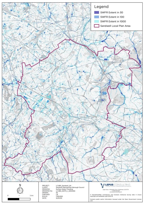
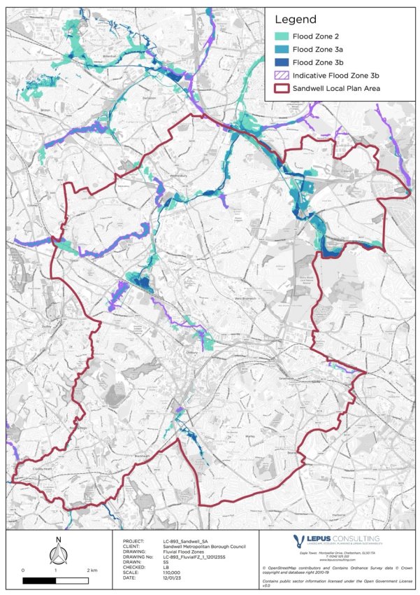
Figure 9.2: Fluvial Flood Zones and Indicative Flood Zone 3b within the SLP area (source: JBA Consulting and Environment Agency)
Green and blue infrastructure
9.2.11 Sandwell's GI network has an important role to play in providing ecosystem services. A well-managed and robust GI network can provide many benefits including for human health, climate change adaptation and wildlife value. GI can play an important role in helping urban areas adapt to climate change, by filtering airborne pollutants, providing shade and local cooling, carbon sink functions, and reducing surface water runoff[85]. The water environment (such as canals, rivers and ponds) can also be referred to as 'blue infrastructure' (BI) and often works alongside GI to provide multi-functional benefits including building resilience to climate change and acting as wildlife refuges and corridors.
9.2.12 Sandwell's GI network includes natural and semi-natural features such as LNRs, SLINCs, SINCs, allotments, playing fields, parks, woodlands, field margins, hedgerows, golf courses and canals. These assets should be protected and enhanced where possible, to increase resilience to climate change as well as increasing wildlife and amenity value.
Key issues for climatic factors include:
- Fluvial and surface water flooding pose significant risks to areas within Sandwell. Flash flooding, resulting from excessive overland flow or overtopping of minor watercourses, is a key issue and as such surface water run-off management and incorporation of effective sustainable drainage systems (SuDS) should be a priority for new developments within the borough. Climate change has the potential to increase the risk of flooding.
- There is a need to increase the quality and quantity of GI within the SLP area, and the wider Black Country, to provide multi-functional benefits including improved carbon storage, urban cooling, natural flood resilience/flood water storage, and provide a more attractive public realm to encourage active travel.
- New development needs to incorporate energy efficiency measures and climate change adaptive features in order to respond to predicted levels of climate change, and to increase low-carbon and renewable energy generation and usage throughout the SLP area.
- A range of further risks linked to climate change may affect the SLP area. These include the following:
- an increased incidence of heat related illnesses and deaths during the summer;
- increased risk of injuries and deaths due to increased number of storm events and flooding;
- adverse effects on water quality from watercourse levels and turbulent flow after heavy rain and a reduction of water flow;
- loss of species that are at the edge of their southerly distribution and spread of species at the northern edge of their distribution;
- an increased move by the insurance industry towards a more risk-based approach to insurance underwriting, leading to higher cost premiums for local business; and
- increased drought and flood related problems such as soil shrinkages and subsidence.
9.3 Impacts on climatic factors
9.3.1 Box 9.1 presents a plan-wide summary of the adverse impacts on climatic factors that have been identified through the SA process, prior to consideration of mitigation or implementation of adaptive technologies.
Box 9.1: Summary of identified impacts on climatic factors
Impact on climatic factors
Summary of identified impact

Fluvial and surface water flood risk
Development within Flood Zones 2 or 3 (including 3a and 3b) has the potential to locate site end users at risk of fluvial flooding, may increase the risk of damage to property and increase risks to human health in the immediate area and/or contribute to exacerbation of flood risk in the surrounding areas.
The majority of allocated sites are located in Flood Zone 1; however, five sites in total partially coincide with some areas of Flood Zones 2 and 3, which makes up 51.86ha of allocated land. These include eight sites with capacity for housing (SH2, SH5, SH16, SH28, SH35, SH36, SH59 and SM2) and employment-led site SEC1-7.
Indicative flood zone 3b is primarily based on an aggregated 1km square grid and is present in areas where flooding will potentially occur in the future due to climate change. Areas of indicative flood zone 3b are predominantly located in the north west and centre of the borough and affect a total of four sites including SEC3-9, SH35, SH36 and SH59.
Additionally, development in areas of surface water flood risk may locate site end users in areas at risk of flooding, with safety implications, and further exacerbate flood risk in the surrounding area.
A total of 78 allocated sites coincide with varying extents of surface water flood risk, including 34 sites with some land identified as high risk.

Increased GHG emissions
The proposed development of 10,434 dwellings and 1,221ha of employment floorspace within the SLP would be likely to increase to some extent local GHG emissions through increased energy demand associated with the occupation of new dwellings and employment premises, transport-related emissions, and the production and use of materials during construction / release of embodied carbon associated with redevelopment sites. This impact will be expected to contribute towards cumulative effects which exacerbate global climate change issues such as sea level rise and extreme weather events.

Loss of multi-functional green infrastructure
The proposed development within the SLP will cumulatively result in the loss of a significant area of previously undeveloped land or land with environmental/ecological value, despite there being 46 allocated sites in areas of previously developed land. Some of the proposed development could potentially also result in the loss of trees, hedgerows and other vegetation currently on site. Multi-functional GI is vital in helping to reduce adverse impacts of climate change.
9.4 Local Plan mitigation
9.4.1 Climate, infrastructure, flood risk, sustainable transport and GI policies within the SLP will be likely to help reduce adverse impacts of the proposed development within the SLP in regard to climatic factors. Policies which are anticipated to help mitigate the impacts identified in Box 9.1, are discussed in Box 9.2.
Box 9.2: Mitigating effects of the Local Plan policies on climatic factors
Policy mitigation for climatic factors
Summary of mitigating effect

Fluvial and surface water flood risk
Policy SCC5: Flood risk sets out measures to identify and manage the risk of flooding throughout the borough and ensure that development is avoided in areas of high fluvial and surface water flood risk, in line with the NPPF. The policy also encourages development proposals to naturalise urban watercourses and open up culverts to provide multi-functional benefits, including for reinstating natural river channels.
Policy SCC6: Sustainable drainage underpins Policy SCC5 in relation to SuDS, outlining design requirements and states that "surface water drainage strategies are required for all major developments, regardless of their size and the flood zone and catchment they are in".
Policies SNE1: Nature Conservation, SDS8: Green and Blue Infrastructure in Sandwell, and SDM1: Design Quality provide measures that would protect and enhance green and blue infrastructure and ecosystem services, with likely multi-functional benefits including for flood risk reduction.
Increased GHG emissions
Various policies support improved low-emission forms of transport provision, including Policy STR1: Priorities for the development of the transport network and Policy STR9: Planning for low emission vehicles, as well as policies STR2, STR3, STR4, STR5, STR6, STR8 and SHW3. These policies support a reduction in private car use through improved public transport connectivity and supporting methods of sustainable and active travel, whilst seeking to improve traffic flow to reduce pollutant emissions.
Policy SCC2: Reducing operational carbon for new build non-residential development, supported by Policy SCC1 – Energy Infrastructure, Policy SDS2: Increasing efficiency and resilience and Policy SDMI: Design Quality, promote energy-efficient development proposals which support low carbon technologies, which will likely result in a decrease of GHG emissions from the construction and occupation of new development.
Policy SCC3: Climate-adapted design and construction aims to reduce the risk of heat gain and the urban heat island effect (UHI) through efficient building design. The policy requires "passive ventilation" and "active cooling systems", in order to reduce heat gain lost to the environment, which has potential for cumulative adverse effects when considering the impacts of global warming as a consequence of climate change.
Policy SCC4: Embodied carbon and waste aims to limit the amount of embodied carbon resulting from the proposed development by completing a whole-life carbon assessment for large-scale developments and considering a range of options for small-scale development.
Policy SDS8: Green and Blue Infrastructure in Sandwell and Policy SNE3: Provision, retention and protection of trees, woodlands and hedgerows encourage enhancements to the provision and connectivity of GI/BI, which will help to support ecosystem service functions such as the filtration of air pollutants and could potentially result in reducing impacts from increased GHG emissions.
Loss of multi-functional green infrastructure
Policy SDS8: Green and Blue Infrastructure in Sandwell sets out how the GI and BI network will be embedded into new development and how its connectivity will be improved across the borough. This policy is underpinned by Policy SCC3: Climate-adapted design and construction, Policy SCC5: Flood Risk, and Policy SHW4: Open Space and recreation, also indicate recommendations to maximise GI provision within Sandwell.
Several policies including Policy SNE1: Nature conservation, Policy SNE2: Protection and enhancement of wildlife habitats, and Policy SNE3: Provision, retention and protection of trees, woodlands and hedgerows seek to improve biodiversity provision and ecological networks and Sandwell, which is likely to positively contribute to the conservation and enhancement of the GI/BI network.
9.5 Residual effects on climatic factors
9.5.1 The SLP sets out several policies which aim to help mitigate the adverse impacts relating to climatic factors (see Box 9.2). However, the implementation of these requirements will not be expected to fully mitigate the adverse impacts associated with net increases in GHGs. Box 9.3 lists the likely residual effects of the Plan in relation to climatic factors.
Box 9.3: Residual effects for climatic factors
Residual effects
Further details of the residual effect
Fluvial and surface water flood risk
The Level 1 SFRA (2024) set out a number of recommendations for SMBC to consider in regard to flood risk, including: to ensure that flood risk is reduced through application of the Sequential Test, and where necessary the Exception Test; to promote SuDS to mimic natural drainage routes; reduce surface water runoff from new developments; to restore natural river corridors and habitats; and to seek opportunities for flood risk betterment.
Assuming that the Sequential Test is passed, or the Exception Test is applied where required, and the recommendations of the SFRA are adopted, the SLP is expected to mitigate potential adverse impacts associated with development in areas at risk of fluvial or surface water flooding.
Increased GHG emissions
The proposed development of 10,434 dwellings and 1,221ha of employment floorspace over the Plan period will be likely to increase to some extent local carbon emissions. Energy demand will be expected to increase in the Plan area, alongside increased congestion and transport related emissions.
Although the policies within Box 9.2 will be expected to have a positive impact in helping to reduce GHG emissions, particularly in regard to energy efficient design, minimising the release of embodied carbon and the utilisation of low carbon sources, these measures are not expected to fully mitigate the impacts associated with the large quantum of growth expected from the SLP.
An increase in GHG emissions as a consequence of the proposed development is expected to be a long-term and permanent significant effect.
Loss of multi-functional green infrastructure
Various SLP policies aim to conserve and enhance multi-functional green and blue infrastructure across the borough, encouraging development proposals to incorporate GI and increase connectivity of the wider GI network. Furthermore, the SLP policies recognise the multi-functional benefits of GI in regard to ecosystem services and ensure development proposals seek to maximise opportunities to implement GI into developments.
The SLP will result in the loss of greenfield land and associated GI to some extent, however SLP policies will ensure mitigation is in place to reduce the loss of GI and protect the wider GI network. A positive effect on provision of GI in the longer term is expected. This would be anticipated to have a positive effect in terms of promoting resilience to climate change.
[74]CCC (2022) Reducing UK emissions: 2024 Progress Report to Parliament. Available at: https://www.theccc.org.uk/publication/progress-in-reducing-emissions-2024-report-to-parliament/ [Date accessed: 20/07/24]
[75] West Midlands Combined Authority (2022) WM2041 Five Year Plan 2021 – 2026. Available at: https://www.wmca.org.uk/what-we-do/environment-and-energy/ [Date accessed: 08/07/24]
[76]Environment Agency (2022) Flood risk assessments: climate change allowances. Available at: https://www.gov.uk/guidance/flood-risk-assessments-climate-change-allowances [Date accessed: 08/07/24]
[77] DBEIS (2022) UK local authority and regional carbon dioxide emissions national statistics: 2005 to 2022. Available at: https://www.gov.uk/government/statistics/uk-local-authority-and-regional-greenhouse-gas-emissions-statistics-2005-to-2022 [Date accessed: 22/08/24]
[78] Ibid
[79] Sandwell Metropolitan Borough Council (2020) Climate Change Strategy 2020-2041. Available at: https://www.sandwell.gov.uk/info/200274/pollution/4402/climate_change_and_air_quality_in_sandwell [Date accessed: 08/07/24]
[80] Bioregional and Edgars (2024) SMBC Local Plan: Net Zero Carbon Policy Support Offsetting.
[81] Urbanist Architecture (2022) How to design Eco, Passivhaus and Zero Carbon Homes. Available at: https://urbanistarchitecture.co.uk/how-to-design-eco-houses-passivhaus-and-zero-carbon-houses/ [Date accessed: 08/07/24]
[82] JBA Consulting (2020) The Black Country Authorities Level 1 Strategic Flood Risk Assessment Final Report 25th June 2020. Available at: https://blackcountryplan.dudley.gov.uk/t2/p4/t2p4h/ [Date accessed: 08/07/24]
[83] JBA Consulting (2024) SMBC Level 1 Strategic Flood Risk Assessment.
[84]Environment Agency (2022) Flood risk assessments: climate change allowances. Available at: https://www.gov.uk/guidance/flood-risk-assessments-climate-change-allowances [Date accessed: 08/07/24]
[85] Landscape Institute (no date) Green Infrastructure (GI). Available at: https://www.landscapeinstitute.org/policy/green-infrastructure/ [Date accessed: 08/07/24]