Sustainability Appraisal of the Sandwell Local Plan 2024-2041
12 Landscape
12.1 Introduction
12.1.1 At the European, national, regional and local levels emphasis is placed on the protection of landscape as an essential component of people's surroundings and sense of place. Landscape is described as comprising natural, cultural, social, aesthetic and perceptual elements. This includes flora, fauna, soils, land use, settlement, sight, smells and sound[98].
12.1.2 Various PPPs seek to increase recognition of the relationships between the different aspects of landscapes including but not limited to local distinctiveness, the historic environment, natural resources, farming and forestry, education, leisure and recreation, transport and infrastructure, and nature conservation.
12.1.3 National Design Guidance[99] advocates well-designed places that are functional, attractive and provide a sense of safety, inclusion and community cohesion. Landscape also links closely with GI, with well-managed GI networks providing multi-functional benefits including improving the health of people and wildlife.
12.2 Baseline and key issues
Green Belt
12.2.1 Sandwell is highly urbanised, with only a small extent of Green Belt land situated to the north east of the SLP area comprising the Sandwell Valley, forming part of the Green Belt surrounding the West Midlands Conurbation. Although Green Belt itself is not necessarily of high landscape value, it often serves to protect the character and setting of historic towns and support landscape-scale biodiversity networks. New development could potentially increase noise and light pollution and reduce the perception of tranquillity in some areas.
12.2.2 Whilst the Green Belt is not a statutory landscape designation, it is a significant element of landscape protection in the area. The Green Belt is intended to[100]:
- check the unrestricted sprawl of larger built-up areas;
- prevent neighbouring towns from merging into one another;
- assist in safeguarding the countryside from encroachment;
- preserve the setting and special character of historic towns; and
- assist in urban regeneration, by encouraging the recycling of derelict and other urban land.
12.2.3 As part of the evidence base for the former BCP, the Green Belt Study[101] classified parcels of Green Belt land into different 'harm' ratings, based on the assessment of potential harm caused by removing each parcel from the Green Belt based on a range of criteria (see Figure 12.1). Appropriate areas of the Green Belt which can support a limited amount of development will be identified through using the findings of the Green Belt Study, where identified housing requirements cannot be met within existing urban areas.
Landscape character and sensitivity
12.2.4 The Black Country Landscape Sensitivity Assessment[102] assessed the sensitivity of Green Belt land to housing and commercial development. The aim of the study was to identify the extent to which the character and quality of Green Belt land is susceptible to change as a result of future development. Parcels of land were classified ranging from 'high' to 'low' sensitivity (see Figure 12.2).
12.2.5 It should be noted that although there is a relationship between the Landscape Sensitivity Assessment and the Green Belt Harm Assessment, the Green Belt Study states that "there are fundamental distinctions in the purposes of the two assessments, reflecting the fact that landscape quality is not a relevant factor in determining the contribution to Green Belt purposes, or harm to those purposes resulting from the release of land".

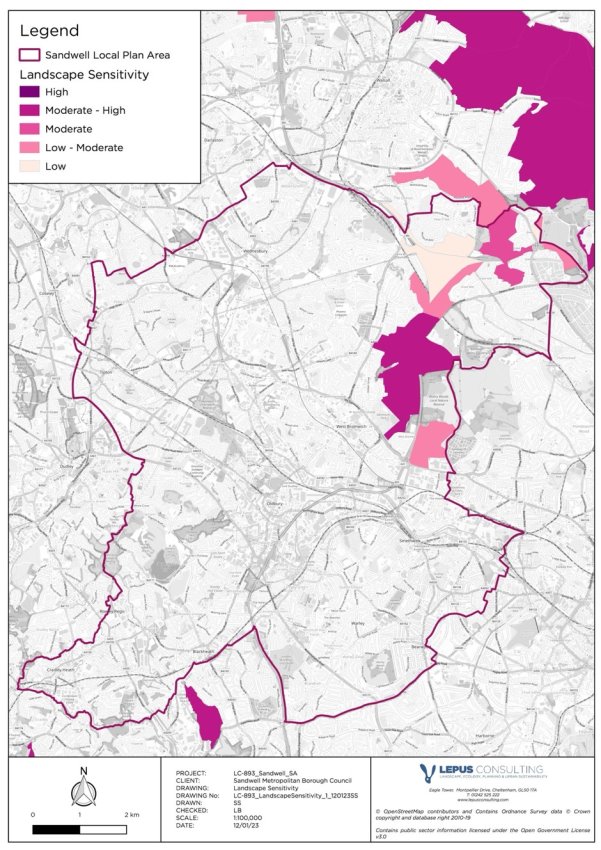
Figure 12.2: Landscape Sensitivity within and around the SLP area (source: LUC)
Townscape character
12.2.6 Townscapes can be defined as "the landscape within the built-up area, including the buildings, the relationship between them, the different types of urban open spaces, including green spaces and the relationship between buildings and open spaces"[103].
12.2.7 The character of townscapes interacts strongly with cultural heritage aspects (see Chapter 10). The Black Country HLC Study[104] identifies 15 Character Areas within Sandwell. The area's history and industrial legacy provides distinctive character and a sense of local identity, but can also present challenges in terms of maintaining and enhancing the local character when historic buildings are no longer in active use.
12.2.8 The emerging SLP should seek to embed the priorities of the Sandwell Regeneration Strategy 2022 - 2027[105] which aspires to rejuvenate Sandwell, boosting the economy and improving quality of life for residents and visitors, whilst remaining in keeping with its history.
Key issues for landscape include:
- The north east of Sandwell lies within the West Midlands Green Belt. Parts of land in this area, within the Sandwell Valley, are identified as being of 'moderate' or 'moderate-high' landscape sensitivity.
- There is a risk that the need for new housing development could increase the risk of encroachment into the remaining undeveloped areas of the borough or alter the character, tranquillity and sense of place in suburban settlements. This includes the Rowley Hills, in the south west of the borough.
- There is a need for new development to be in accordance with the scale and character of the local area and seek to conserve and enhance the quality of the surrounding landscape or townscape.
12.3 Impacts on landscape
12.3.1 Box 12.1 presents a plan-wide summary of the adverse impacts on landscape that have been identified through the SA process. These adverse impacts are those identified prior to mitigation considerations.
Box 12.1: Summary of identified impacts on landscape
Impact on landscape
Summary of identified impact

Threaten or result in the loss of locally distinctive or sensitive landscapes
The introduction of new built form can contradict and conflict with distinctive local landscapes and townscapes which can result in adverse impacts on sensitive landscapes and loss of local character.
The Black Country Landscape Sensitivity Assessment[106] considered the landscape and visual aspects of green belt parcels in and around Sandwell and the Black Country. No allocated sites lie within the landscape sensitivity assessment area, and consequently the impact of all allocated sites on distinctive landscapes remains uncertain.
Information relating to the historic environment which has strong links with landscapes/townscapes in Sandwell, including the Historic Landscape Characterisation and associated designations, has been discussed within Chapter 10: Cultural heritage).
12.4 Local Plan mitigation
12.4.1 The spatial strategy for Sandwell sets out the aim to deliver the majority of new development on previously developed land and sites within the urban area, as well as protecting areas of landscape value. However, to meet the identified housing requirements, a large proportion of growth is allocated on previously undeveloped land. Various SLP policies aim to protect and, where appropriate, enhance the local character and distinctiveness of Sandwell's landscapes and townscapes. These policies are discussed in Box 12.2.
Box 12.2: Mitigating effects of the Local Plan policies on landscape
Policy mitigation for landscape
Summary of mitigating effect

Threaten or result in the loss of locally distinctive or sensitive landscapes
Policy SHE1: Listed buildings and conservation areas states that development proposals will be required to "conserve and enhance local character". This is supported by Policies SHE2: Development in the historic environment, SHE3: Locally listed buildings and SHE4: Archaeology, which will ensure the protection and enhancement of heritage assets within the borough to positively contribute to local character and distinctiveness.
Policy SDS8: Green and blue infrastructure in Sandwell provides measures to support green and blue infrastructure within the borough, which is expected to positively contribute to the locally distinctive landscape and townscape character. Policy SDS2: Increasing efficiency and resilience supports this by encouraging an increase in green cover and the incorporation of "landscaping schemes".
Policy SNE3: Provision, retention and protection of trees, woodlands and hedgerows supports the provision, retention and protection of trees, woodlands and hedgerows, which would also be expected to contribute towards the conservation and enhancement of landscape character through urban greening.
Policy SNE5: The Rowley Hills aims to protect the Rowley Hills from inappropriate development that will lead to the loss of valued qualities that make up the local landscape character, including panoramic views.
Policies SDM1: Design quality, SDM2: Development and design standards, SDM3: Tall buildings and gateway sites, SDS5: Achieving well-designed places and other Development Management policies seek to ensure that new development creates a strong sense of place and help to conserve and enhance the landscape / townscape character, and will ensure the visual effects of relevant proposals (such as tall buildings) are identified and assessed.
Many SLP policies including Policy SDS1: Spatial Strategy for Sandwell and SDS3: Regeneration in Sandwell encourage regeneration and redevelopment of industrial land, town centres and canal corridors with potential opportunities for enhancement of Sandwell's townscapes which can contribute to creating a strong sense of place and improve the appearance and function of urban areas.
12.5 Residual effects on landscape
12.5.1 The SLP sets out numerous policies which will be expected to help mitigate potential adverse impacts of the proposed development on the landscape, as set out in Box 12.2. As discussed in Box 12.3, these policies are expected to be sufficient in mitigating any residual impacts on landscape.
Box 12.3: Residual effects for landscape
Residual effects
Further details of the residual effect
Threaten or result in the loss of locally distinctive or sensitive landscapes
Various Local Plan policies seek to ensure that development proposals maintain and improve the distinctiveness of Sandwell's landscape and townscape character, including through the provision of green infrastructure, urban greening, the protection of historic assets, appropriate design and the consideration of views from sensitive landmarks such as the Rowley Hills. Where relevant, the SLP policies will ensure the potential for adverse effects is explored, including through LVA/LVIA to inform the development of any tall buildings. As a consequence, it is likely that any potential adverse impacts on landscape will be fully mitigated, even where these currently remain uncertain. An overall positive effect is expected, particularly where developments seek to enhance and regenerate Sandwell's landscape, townscape and historic environment.
[98] Natural England (2014) An Approach to Landscape Character Assessment. Available at: https://www.gov.uk/government/publications/landscape-character-assessments-identify-and-describe-landscape-types [Date accessed: 08/07/24]
[99] MHCLG (2023) National Design Guide: Planning practice guidance for beautiful, enduring and successful places. Available at: https://www.gov.uk/government/publications/national-design-guide [Date accessed: 08/07/24]
[100]MHCLG (2023) NPPF, Chapter 13: Protecting Green Belt land. Available at: https://www.gov.uk/government/uploads/system/uploads/attachment_data/file/6077/2116950.pdf [Date accessed: 08/07/24]
[101]LUC (2019) Black Country Green Belt Study. Available at: https://blackcountryplan.dudley.gov.uk/media/13882/bcgb-0919-black-country-gb-stage-1-and-2-plus-app1-final-reduced_redacted.pdf [Date accessed: 08/07/24]
[102] LUC (2019) Black Country Landscape Sensitivity Assessment. Available at: https://blackcountryplan.dudley.gov.uk/media/13883/black-country-lsa-front-end-report-final-lr_redacted.pdf [Date accessed: 08/07/24]
[103] Landscape Institute (2017) Townscape character assessment. Available at: https://www.landscapeinstitute.org/technical-resource/townscape/ [Date accessed: 08/07/24]
[104]Oxford Archaeology (2019) Black Country Historic Landscape Characterisation Study. Available at: https://blackcountryplan.dudley.gov.uk/media/13895/comp_black-country-hlc-final-report-30-10-2019-lr_redacted.pdf [Date accessed: 08/07/24]
[105] Sandwell Metropolitan Borough Council (2022) Sandwell Regeneration Strategy 2022 – 2027. March 2022. Available at: https://regeneratingsandwell.co.uk/wp-content/uploads/2022/09/Regeneration-Strategy-2022-2027.pdf [Date accessed: 08/07/24]
[106] LUC (2019) Black Country Landscape Sensitivity Assessment. Available at: https://blackcountryplan.dudley.gov.uk/media/13883/black-country-lsa-front-end-report-final-lr_redacted.pdf [Date accessed: 21/08/24]