Sandwell Local Plan Main Modifications Consultation
MAIN Modifications
[CHS - Council’s Hearing Statement]
[PAM – proposed additional modification -examination document SA/ED3]
MM1 View responses
Page / paragraph / policy reference
various
Proposed change
Update housing supply figure from 10,434 to 11,901 throughout plan, plus consequential and related changes
Update unmet housing need figure from 15,916 to 14,449 homes throughout plan.
Reason
Update
MM2
Page / paragraph / policy reference
Following paragraph 10 - 11
Proposed change
Reference in text to list of superseded policies and documents in Appendix N (now Appendix L).
12. The SLP includes some policies based on original versions found in the SAD and BCCS, and others based on the policies set out in the draft Black Country Plan. A list of previously adopted policies and other planning documents that are superseded by the SLP is included in Appendix L, together with references to the specific SLP policies that replace them.
Reason
Clarification
MM3 View responses
Page / paragraph / policy reference
Paragraph 17 - 18
Proposed change
Amend text:
17. Agreement through Statements of Common Ground (SoCG) are now a necessity and will document the cross-boundary matters that need to be are being addressed and what progress has been made in dealing with them.
Delete text:
18. Discussions are ongoing with neighbouring authorities and potential contributions to the Black Country and the Greater Birmingham and Black Country Housing Market Area (GBBC HMA) have been offered in several Local Plans, however these are still to adopted and the offers may change. The DtC statement sets out where and with whom discussions have taken place and how the council has sought to address the shortfall, it will also include Statements of Common Ground (SoCG) that have been agreed to date. The table below sets out the potential contributions following discussions to date and will be updated as necessary and when contributions have been confirmed:
Update and amend table:
Table 1 – Duty to Cooperate Contributions
|
Contributing Authority |
Contribution to |
Land Type |
Total Potential Contribution |
Sandwell’s Confirmed apportionment |
|
Shropshire Council* |
|
|
|
|
|
|
|
|
||
|
South Staffordshire |
GBBC HMA |
Residential |
640 |
0 |
|
Black Country Authorities |
Employment |
112.2ha |
0 ha |
|
|
Cannock |
GBBC HMA |
Residential |
500 |
0 |
|
Telford |
Black Country Authorities |
Residential |
|
0 |
|
|
|
|
||
|
|
|
|||
*Shropshire withdrew their plan in July 2025, so their contribution has also now been withdrawn.
** Contribution based on publication version of Telford’s plan, February 2025
Reason
Update
MM4
Page / paragraph / policy reference
Paragraph 2.6
Proposed change
Amend text:
The SLP provides for around one third nearly half of the its housing need on the land that is available in Sandwell.
Reason
Clarification and correction
MM5 View responses
Page / paragraph / policy reference
SDS1.1a
Proposed change
Include reference to plan period:
… a. deliver at least 10,434 11,901 net new homes across the plan period and create sustainable mixed communities …
Reason
Clarification and amendment
Page / paragraph / policy reference
SDS1.1b
Proposed change
Insert new criterion b, subsequent bullet points renumbered:
b. seek to meet existing Gypsy, Travellers and Travelling Showpeople needs as far as possible.
Add reference to plan period and signpost to employment policies (except Policy SEC4):
b. c. maintain the ongoing provision of around 1,221ha of allocated employment land, across the plan period, (of which 28ha is currently vacant) (Policies SEC1 – SEC3);
Reason
Page / paragraph / policy reference
SDS1.1c View responses
Proposed change
Reflect the changes made to paragraph 89f (AM8):
c. ensure that sufficient physical, social, emergency services, utility and environmental infrastructure is delivered to meet identified requirements;
Reason
Page / paragraph / policy reference
SDS1.1h View responses
Proposed change
Amend to refer to exceptional circumstances:
h. protect the openness, integrity and function of Sandwell’s designated green belt by resisting inappropriate development in it, except in circumstances as set out in national guidance;
Reason
Page / paragraph / policy reference
SDS1.1i
Proposed change
Include a reference to Nature Recovery:
… by resisting inappropriate development in it;
i. protect habitats and areas of ecological value and support nature recovery;
j. conserve the significance …
Reason
Page / paragraph / policy reference
SDS1.1j View responses
Proposed change
Amend text:
j) conserve the significance of the historic environment, particularly in relation to designated heritage assets and their settings, ...
Reason
Page / paragraph / policy reference
SDS1.2 View responses
Proposed change
Amend text:
2. The SLP seeks to ensure this growth is sustainable by requiring the following issues are addressed in planning proposals:
… b. allocating ensuring housing is delivered in locations with the highest levels of sustainable transport access to residential services (e.g. retail provision, schools, healthcare facilities, fresh food, employment etc.), such as near railway stations, metro stops and public transport hubs, and making effective use of land through the application of minimum densities (Policy SHO3):
d. allocating ensuring new employment land is delivered in locations where sustainable access … Add a new criterion on designing out crime and addressing public safety: … and minimise detrimental impacts on the transport network;
h. ensuring all new development is designed to minimise the opportunities for crime and antisocial behaviour to occur and to optimise public and individual safety;
h i. supporting and enhancing the sustainability …
Reason
Page / paragraph / policy reference
SDS1.3 Paragraph 3.3 View responses
Proposed change
Amend criterion 1.3 of policy to include reference to strategic sites:
Appendices B and C Chapters 16 and 17 show how the housing and employment land ambitions for Sandwell will be met. They include strategic site policies for housing and employment and mixed use, and non-strategic allocations. Those development needs that cannot be accommodated within the borough will be exported to sustainable locations …
Amend justification text to identify sources of supply:
3.3 The economy and population of Sandwell are both growing. The Council needs to plan for continued economic recovery and growth and enhanced business productivity. It has also identified land a housing supply for at least 10,434 11,901 new homes within the plan period. This comprises identified sites, windfall allowance, additional floorspace in centres and additional supply identified in the Wednesbury Masterplan. To accommodate this future growth, sites and locations that are both sustainable and deliverable have been identified for development, at levels that do not breach the environmental capacity of the area.
Introduce new paragraph 3.4:
3.4 In Chapter 16, the Council has identified sites that it considers to be of strategic importance in delivering the housing and employment land needed in Sandwell. Reflecting local circumstances, strategic housing sites are defined as sites capable of delivering over 500 dwellings; sites identified in the West Bromwich and Grove Lane Masterplans are identified as providing strategic benefits. These sites represent a significant proportion of the planned housing growth and are critical to achieving housing requirement of the Sandwell Local Plan.
3.5 One strategic employment site has been allocated. It is a vacant site of over seven hectares that was identified and assessed through the Black Country Economic Development Needs Assessment and Black Country Employment Area Review as important to the delivery of strategic economic growth.
3.6 A mixed-use site has also been identified as of strategic importance, as it provides for a significant amount of housing and employment land in a location with very good links to the strategic highways network.
Consequential renumbering of subsequent paragraphs
Reason
MM6
Page / paragraph / policy reference
SDS2.2 View responses
Proposed change
Amend policy text to reflect flexibility:
2. Proposals for development will need to demonstrate how they have been designed to maximise resistance and resilience to climate change through addressing the following requirements where relevant and in accordance with other policy obligations: …
Amend text:
… 2b. development proposals will need to meet the needs of all sections of the community …
Reason
Clarification and consistency
Page / paragraph / policy reference
SDS2.2 e View responses
Proposed change
Amend text:
e. where practicable, all development will need to utilise sustainable drainage systems, which should be built into landscaping schemes / open space provision as appropriate (Policy SCC6), and prioritise natural drainage solutions …
Reason
Page / paragraph / policy reference
SDS2.2.h
Proposed change
Amend text:
h. applications for planning permission proposals for development should promote circular economy outcomes and seek to reduce whole life-cycle carbon emissions…
Reason
Page / paragraph / policy reference
SDS2.2 i View responses
Proposed change
Amend text:
... where this will not cause an unacceptable level of harm to the historic fabric, character, setting or appearance of the asset ...
Reason
Page / paragraph / policy reference
SDS2.2 j View responses
Proposed change
Amend text:
Proposals for development related to climate change adaptation and mitigation that would adversely affect the setting significance of heritage assets should be designed to avoid such impacts. Where this is not possible, developers must demonstrate that schemes have been designed to minimise those impacts. Where this cannot be demonstrated, the presumption will be against the grant of planning permission (Policies SHE1 – SHE4).
Reason
MM7
Page / paragraph / policy reference
SDS3.3b
Proposed change
Amend text:
b. As set out in the West Bromwich Masterplan residential and employment growth will be sought at a transformational level to help create a vibrant and sustainable town centre with a diverse range of uses…
Reason
Clarify definition of “transformational”
Page / paragraph / policy reference
SDS3.6a
Proposed change
Amend wording:
… the SLP Policies Plan Map.
Reason
correction
Page / paragraph / policy reference
SDS3.7 b View responses
Proposed change
Amend text:
... b. Retail, residential, and mixed-use development will be encouraged in Wednesbury Town Centre40
40 Please also see Appendix D B and https://regeneratingsandwell.co.uk/sandwell_projects/wednesbury-high-street-heritage-action-zone/
Reason
Include further clarification on Heritage Action Zone work
Page / paragraph / policy reference
SDS3.8d and e
Proposed change
Additional text:
d.The principal locations for new industrial and logistics development – providing at least 584495ha of employment land, designated as SEC1, 2 and 3 sites on the SLP Policies Plan, to meet growth needs.
e. A minimum of 2,134 3,037 new homes (discounted) of mixed type and tenure….
Reason
Clarify origin of figure and update.
Deletion of “discounted” for consistency with rest of SLP
Page / paragraph / policy reference
Paragraph 3.36c
Proposed change
Correct figures:
… they include clusters of housing / employment development opportunities providing at least 2,219 3,037 homes (discounted, these sites are already included in the supply detailed in Policy SHO1) and 584 495ha of strategic and local employment areas.
Reason
MM8
Page / paragraph / policy reference
SDS4.1a
Proposed change
Amend text:
1. Towns and local communities outside West Bromwich and the regeneration areas identified in Figure 3 will provide:
- a minimum of
4746,503 new homes delivered through:- the allocation of previously identified housing sites, or ones submitted as part of
athe Local Plan Call for Sites exercise49; - the repurposing of a small number of brownfield employment sites and other previously developed and surplus land for new housing;
small-scaleresidential development on windfall sites submitted through the planning application processopportunities in highly sustainable locations;
- the allocation of previously identified housing sites, or ones submitted as part of
Reason
Clarification and correction to refer to all parts of the borough outside the regeneration areas.
Express housing target as a minimum.
Clarify call for sites exercise.
Consistency in referring to small scale sites
Page / paragraph / policy reference
SDS4.1c View responses
Proposed change
Additional text:
c. Approximately 637 726ha of identified employment land, designated as SEC1, 2 and 3 sites on the SLP Policies Map, to meet employment needs;
Reason
Page / paragraph / policy reference
Paragraph 3.58
Proposed change
Amend text:
Policy SDS4 sets out the strategic approach for Sandwell’s other towns and local areas towns and local areas outside of the regeneration areas.
Reason
Page / paragraph / policy reference
Paragraph 3.59
Proposed change
Additional justification text:
Sandwell is made up of several towns and small local communities and is a highly urbanised area. It also contains various existing local employment areas. Towns and local areas outside of the regeneration areas (SDS3) will provide at least 6,507 new homes and 726ha of identified employment land.
Reason
MM9
Page / paragraph / policy reference
SDS5.1 View responses
Proposed change
Amend the policy wording to address any hiatus prior to the adoption of the Council’s own Design Code:
- A Design Code supplementary plan will be produced for Sandwell, reflecting local character and design preferences, and providing a framework for creating high quality places. Prior to this being produced and adopted, the Council expects applicants to have regard to the requirements of the National Model Design Code, the West Midlands Design Code and Sandwell’s extant design guidance, as well as to the design-related requirements of all relevant policies in the SLP itself.
- In some cases, the Council may work with applicants to approve a masterplan or site-specific design code to meet the requirements of a site and its surrounding environment (see Policy SDM1 and supporting text).
2.The design of new development will be expected …
Reason
Update
Page / paragraph / policy reference
SDS5.5
Proposed change
Amend text:
5. … make a positive contribution to place-making and environmental improvement (Policies SNE1 – SNE3), including through the provision of green and blue infrastructure and improvements to local biodiversity, using design codes, design and access statements, ….
Reason
MM10 View responses
Page / paragraph / policy reference
SDS6
Proposed change
Amend the title of the policy to reference Community Facilities.
Policy SDS6 – Cultural and Community Facilities and the Visitor Economy
Make changes to parts 1, 3 and 6 of Policy SDS6 and in justification text.
Development proposals
1. Cultural, tourist, and leisure and community facilities within Sandwell will, wherever possible, be protected, enhanced and expanded (where appropriate) in partnership with key delivery partners and stakeholders.
3. Proposals for new cultural, tourist or leisure and community facilities or uses, or extensions to existing ones, should:
a. be of a high-quality design;
b. be highly accessible and sustainable, being located within centres wherever possible;
c. not adversely impact on residential amenity or the operation of existing businesses; and
d. be designed to be flexible, adaptable, and where possible be capable of alternative or community use.
6. Development that would lead to the loss of an existing cultural / tourism/ community facility in Sandwell will be resisted unless:
a. the intention is to replace it with a facility that will provide an improved cultural, or tourist or community offer;
b. it can be demonstrated that there would be significant benefits to the local and wider community in removing the use and / or redeveloping the site; or
c. An appropriate contribution is made to support and sustain an alternative local cultural, tourist, or leisure or community facility.
Para 3.85
The range and diversity of cultural, and tourist and community assets in the Black Country…..
Reason
Clarification
Page / paragraph / policy reference
SDS6.1 SDS6.6
Proposed change
Signpost to SDM9:
1.Cultural, tourist and leisure facilities within Sandwell will, wherever possible, be protected, enhanced and expanded (where appropriate) in partnership with key delivery partners and stakeholders (see Policy SDM9).
Amend policy to make clear the position where a facility becomes redundant to the current user:
6. Development that would lead to the loss of an existing cultural / tourism facility in Sandwell will be resisted unless:
…
c. An appropriate contribution is made to support and sustain an alternative local cultural, tourist or leisure facility;
d) In cases where an established community or cultural facility is declared redundant, prior to considering any application for its change of use or redevelopment the Council will require robust evidence to be submitted thatdemonstrates the owners / occupiers have sought to retain it in its current or a very similar use. This could vary depending on the nature of the use but might typically include evidence of the marketing of the facility over a 6 – 12-month period for its current use (depending on the nature or complexity of that use or the facility).
Reason
Page / paragraph / policy reference
SDS6.14
Proposed change
Amend text:
14. In cases where new development could potentially prejudice the successful ongoing operation of an adjacent cultural/ religious / performance venue, the agents of change principle will be applied53. This will be supported by a general presumption against the loss of such facilities unless the parameters set out in Section 6 can be met.
Reason
MM11
Page / paragraph / policy reference
SDS7 Paragraph 3.99 View responses
Proposed change
Amend policy:
SDS7 – Sandwell’s Green Belt
1. Sandwell Council will maintain a defensible boundary1 around the Sandwell green belt, to help promote urban renaissance, to maximise its role in helping to mitigate climate change impacts and to support easy access to the countryside for residents.
2. Sandwell green belt’s nature conservation, landscape, heritage and agricultural value will be protected and enhanced.
3. 2. Opportunities will be taken to improve the value and recreational role of the green belt in Sandwell Valley:
a. through improving safe accessibility for all users;
b. by providing facilities for active and passive recreation (if this preserves the openness of the Green Belt and does not conflict with the purposes of including land within it2);
c. by protecting tranquil areas and locations with ecological and historic value.
4. Extensions to existing buildings, the re-use of buildingsx or limited infilling / redevelopment / replacement of them within the footprint of an existing developed site within Sandwell’s Green Belt will be considered for approval provided:
a. extensions are not disproportionately over and above the size of the existing building(s) as originally constructed;
b. for replacement buildings, the new building is in the same use and not materially larger than the one it replaces;
c. the scale, materials and general design of the proposed development or redevelopment are in keeping with the character of the buildings and their surroundings and avoid greater impact and harm to the openness of the Green Belt; and
d. it does not lead to an increase in the developed proportion of the overall site.
3. In determining planning applications, the Council will apply national policy either in the NPPF or its successor.
…
X Provided they are of permanent and substantial construction.
Amend justification to support the revised policy:
Justification
…
3.99 In accordance with the implementation arrangements set out in the NPPF published on 12 December 2024 (revised 7 February 2025), this plan was examined under the relevant previous version of the NPPF dated December 2023. However, for decision-making purposes, the NPPF (2024) paragraphs 231 – 233 states that policies within the 2024 framework are material considerations in dealing with applications.
3.96 Sandwell Council recognises that the space needs of existing uses can change and evolve over time and some activities may require additional space. To remain in their current premises and to support a thriving community and economy, facilities currently located in the green belt may need to extend or alter their current operational buildings.
3.97 To ensure the openness of the green belt is maintained, any extensions or alterations to buildings in it must not result in additions that are disproportionately over and above the size of the original building. For all non-residential buildings, the ‘original building’ is taken to be a building as it existed on 1 July 1948 or, if constructed after 1 July 1948, as it was built originally.
3.100 3.98 While green belt is not itself a reflection …
Amend text:
3.99 3.101 Consultants were commissioned by the Black Country authorities to complete a study of the sub-region’s green belt in 2019 . The study divided the green belt into different parcels based upon common features. It assessed each parcel against the five purposes of the green belt set out in the NPPF and reached conclusions on the level of harm that would occur if land were released for development. It is the Council’s view that there are no exceptional circumstances in Sandwell that would justify amending current boundaries and releasing any areas of green belt for new development. While there is an identified shortfall of land suitable for housing and economic development, this of itself does not outweigh the need to maintain the openness and permanence of the green belt within Sandwell, especially given the densely developed and urban character of the rest of the borough.
Reason
Remove duplication of national guidance and policy.
MM12
Page / paragraph / policy reference
Paragraph 4.3
Proposed change
Correct paragraph number from 4.3 to 4.4. Consequential renumbering throughout chapter.
Explain the use of the15km impact zone created as a response to the requirements of the Habitats Regulations:
4.4 Development in Sandwell …
…
- ensuring that developments adjacent to canals and natural watercourses deliver improved and extended corridors for the movement of wildlife and people.
4.5 A report was commissioned by a group of local authorities in the region (including Sandwell and the other Black Country councils) to gauge the potential impacts of development on the region’s Special Areas of Conservation, in relation to likely impacts on air quality. This resulted in the carrying out of an Appropriate Assessment on plans and proposals during the drafting of the Sandwell Local Plan, which itself formed part of the assessment.
4.6 During the production of the report, changes were made to the Nitrogen Deposition Critical Load Ranges in the UK’s Air Pollution Information System (APIS). The work being undertaken was based on the old Nitrogen Deposition Critical Load Ranges in APIS. Natural England advised that any local plan currently at Regulation 19 stage could continue using the old critical load ranges, but that acknowledgement should be made of the changes in critical loads since the air quality was modelled. For plans at other stages, councils were informed that they should ensure their local plans reflected the current critical load ranges in APIS. The work in question, the Assessment of Air Quality Impacts European Sites in Staffordshire, Wolverhampton, Walsall, Sandwell, and Dudley Report should be updated to reflect the changes in the figures.
4.7 Criterion 1 of Policy SNE1 ensures that where development (alone or in combination with other separate development proposals) may have an adverse impact on sites of European importance, it undergoes an appropriate assessment. This will be in the form of a Habitats Regulation Assessment (HRA). The purpose of a HRA is to determine if a plan or project would affect the protected features of certain habitat sites, such as Special Areas of Conservation (SAC), Special Protection Areas (SPA) or Ramsar sites.
4.8 While Sandwell does not itself contain any European sites, it does lie close to several SACs and just outside the 15km zone of influence of Cannock Chase, also a SAC. As a result, the Council undertook work through the HRA for the Sandwell Local Plan, and with the Cannock Chase SAC Partnership, to ensure that the SLP (alone or in combination) would not have adverse impacts on European sites in the vicinity or further afield.
Subsequent paragraphs renumbered.
Reason
Drafting error
Clarification and amendment following examination
Page / paragraph / policy reference
SNE1.3 View responses
Proposed change
Amend wording:
3. Species and habitats that are legally protected …
Reason
Page / paragraph / policy reference
SNE1.4 View responses
Proposed change
Amend wording:
…a local nature conservation site (Sites of Local Importance for Nature Conservation), protected or priority species, habitat, or geological feature damage must be minimised …
Reason
Page / paragraph / policy reference
SNE1.5 View responses
Proposed change
Amend criterion 5 to reflect the importance of enhancements to wildlife corridors:
Developers must take account of the Local Nature Recovery Strategy (Policy SNE2) when preparing their schemes and should plan for the maintenance and where possible enhancement of such linkages. Areas identified on the Sandwell Policies Map as wildlife corridors will be particularly suitable for enhancement and protection, and this will be required when planning proposals are brought forward that would affect them. Where such sites also fall within the West Midlands LNRS in areas of strategic significance a 15% uplift in the value of biodiversity net gain units located within them will also apply.
Reason
Page / paragraph / policy reference
SNE1.7 View responses
Proposed change
Amend criterion 7 to acknowledge that the ecological value of habitat sites may change over time:
… and will amend existing designations in accordance with this evidence. Consequently, sites may receive new or increased, amended levels of protection over the Plan period, including occasionally their de-designation as a SINC or SLINC.
Reason
Page / paragraph / policy reference
Paragraph 4.5 View responses
Proposed change
Update text:
… development proposals should incorporate the recommendations from the Black Country West Midlands Local Nature Recovery Strategy Opportunity Map …
Reason
Page / paragraph / policy reference
Paragraph 4.7 View responses
Proposed change
Amend wording:
4.7 Development offers an opportunity to improve the local ecological and geological environment, and this is especially so in an urban area.
Update and amend text:
… will identify, map, and regularly review the priorities for protection and improvement throughout the Black Country, in accordance with the emerging Black Country Local Nature Recovery Network Strategy. These will be used to inform planning decisions. As set out in criterion 4, where the planning merits of a proposed development have the potential to outweigh the ecological, geological or environmental value of a SLINC, any suggested mitigation strategy for its loss or partial loss will need to be based on a clear understanding of the current value of the site, using up-to-date evidence. The Local Environmental Records Centre …
Reason
Page / paragraph / policy reference
Paragraph 4.9 View responses
Proposed change
Add new paragraph, renumber as necessary:
Potential Sites of Importance
4.9 Potential Sites of Importance (PSIs) are areas that may support notable species, valuable semi-natural habitats, or important geological features but that have not yet been formally assessed against local wildlife and geological sites selection criteria. These sites are identified using aerial photography, historic mapping, existing environmental records, and local knowledge and EcoRecord holds details of their locations. PSIs are often undeveloped or semi-natural areas that contribute to local ecological networks by providing habitat, supporting biodiversity, and offering opportunities for restoration and enhancement. They play an important role in delivering Local Nature Recovery Strategy objectives and wider national biodiversity goals.
4.10 Where a planning application is likely to have an impact on a PSI, the potential effects on its ecological or geological value must be assessed. If effects are identified, appropriate mitigation or compensation measures will be sought where appropriate. Undertaking a Local Site assessment at the pre-application stage may help determine whether the site meets the criteria for designation.
Protection and Enhancement of Wildlife Habitats
4.9 4.11 The Environment Act (2021) …
Reason
MM13 View responses
Page / paragraph / policy reference
Figure 1 Appendix A View responses
Proposed change
Figure 1 of Appendix A will be replaced with a link to the West Midlands Local Nature Recovery Strategy map on the WMCA website.
[see also AM21]
Figure 1 - Sandwell Nature Recovery Network map

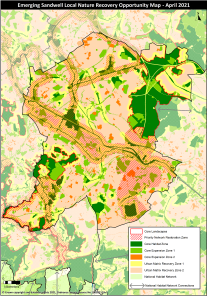
Reason
Update
MM14
Page / paragraph / policy reference
Appendix A Figure 2
Proposed change
Figure 2 of Appendix A (now revised Figure 1) amended to identify those habitat banks identified in Policy SNE2 only.
The following map identifies the list of sites that were ranked by the consultants as being of high and medium value for BNG improvements and are identified as habitat banks.
Amend habitat bank mapping for Menzies Open Space, Tibbington Open Space and Tividale Park to clarify areas currently in use as or identified as playing pitches.
Clarify supporting text in Appendix A as follows:
Exclusion of certain open space typologies from consideration – allotments, cemeteries and churchyards, institutional land (schools, hospitals, sports grounds and reservoirs), outdoor sports facilities (including playing pitches) and provision for children and young people.
Amend title of (revised) Figure 1:
Figure 1 - Location of Sandwell habitat bank sites
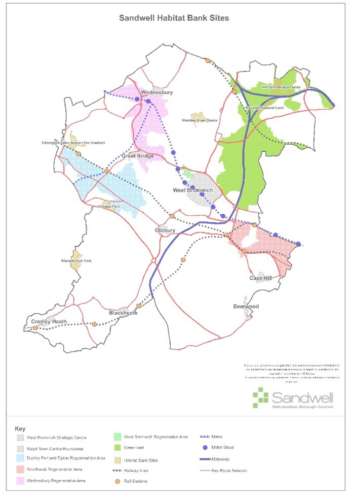
Reason
Clarification and update
MM15
Page / paragraph / policy reference
SNE2.1 View responses
Proposed change
Amend wording:
AllDevelopment proposals in Sandwell shall deliver a minimum 10% net gain in biodiversity valuex…Where achievable, a higher net gain may be agreed.Losses and gains will be calculated using the extant national Biodiversity Metricx. Proposals that offer more than 10% BNG on development sites will be welcomed and the additional ecological value will be considered positively when a decision is made on the relevant planning application.
XSubject to exemptions set out in national guidance
Reason
Clarification and correction
Page / paragraph / policy reference
Paragraph 4.14 View responses
Proposed change
Explain modification to Policy SNE2.1 in supporting text.
Include explanatory paragraph after 4.14 on the clearance of sites prior to the submission of a planning application:
4.14 …and an estimation of how proposed designs will add to that current level, supported by evidence that a minimum 10% net gain has been delivered. Where a development proposal is designed in such a way that more than 10% BNG will be delivered, the Council will look favourably on this higher provision, in particular where it addresses other policy objectives and helps to meet the wider aims of the Local Nature Recovery Strategy such as strengthening ecological networks and creating stepping stone sites between larger green areas.
4.15 The government have established the date of 30th January 2020 as a baseline for the assessment of BNG. Any site clearance that occurs after this date that is not related to the grant of planning permission will have its BNG measured against what was on site at the baseline date, using historic records, aerial imagery, habitat data and other relevant information. The baseline ecological value is also taken as being at a level commensurate with the most important or sensitive ecological records applying to the site, as part of a precautionary approach. This means that the level of BNG required to be delivered would be at the highest level possible for that site.
Reason
Page / paragraph / policy reference
SNE2.2 View responses
Proposed change
Amend text:
... 2. Biodiversity net gain must be provided in line with the following principles(X): ...
(x) See also Paragraph: 008 Reference ID: 74-008-20240214 of the national Biodiversity Net Gain guidance
Reason
SNE2.6 View responses
Page / paragraph / policy reference
Amend text:
Sandwell Council has identified the following site(s)65 as suitable for the provision of biodiversity units to developers unable to provide a minimum 10% net gain on their own sites (see Appendix A and evidence base):
Amend table of sites:
| Location | Potential project types | Baseline units | Potential uplift units (%) |
|---|---|---|---|
Ray Hall Pastoral Land |
Comprises an area of natural and semi-natural greenspace containing several fields of pastures divided by hedgerows with trees. Ray Hall Pastoral Land contains pockets of poor and moderate ‘other neutral grassland’ which is divided by woodland and scrub. The grassland and woodland habitats offer the most potential for uplift. NB – Ray Hall pastoral land and Hill Farm Bridge Fields will be treated as a single site. |
87.75 |
+48.05 (54.76) |
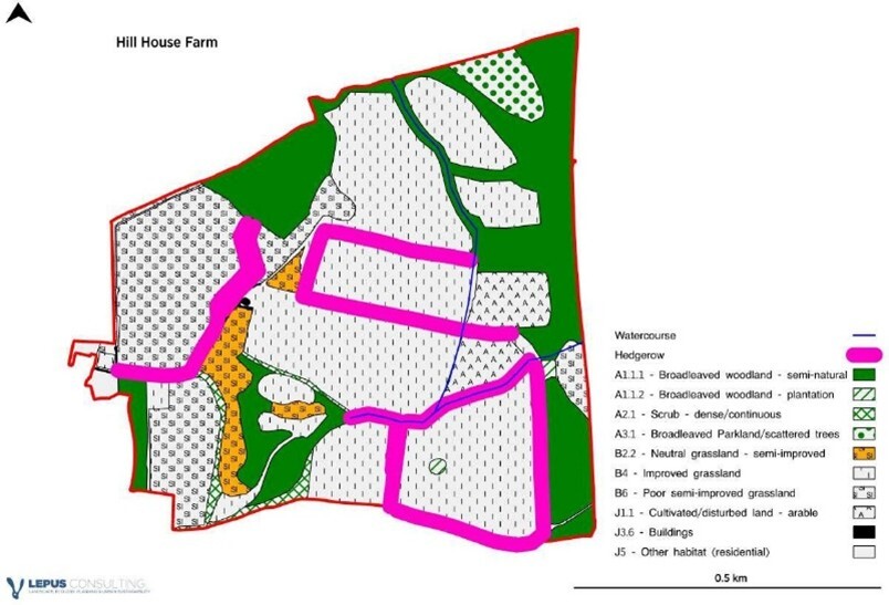
Amend accompanying plans (Appendix A):
Delete plan of Hill House Farm, replace with one of Ray Hall pastoral land

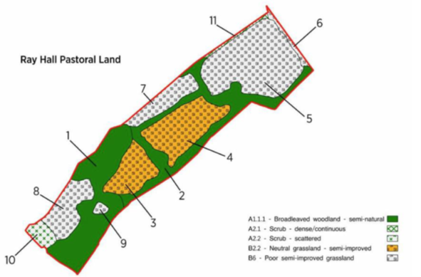
For consistency, refer to the six sites as “habitat banks” throughout the SLP and on the Policies Map
Proposed change
Location
Reason
Potential project types
Page / paragraph / policy reference
SNE2.8 View responses
Proposed change
Amend text:
Priority locations for habitat creation and enhancement are as shown on the Sandwell West Midlands Local Nature Recovery Strategy mapx (Appendix A ). Development sites within areas of particular importance for biodiversity the identified zones will be expected to contribute towards the creation of appropriate habitat linkages and types to support those priority areas.
Xhttps://www.wmca.org.uk/what-we-do/environment-energy/west-midlands-local-nature-recovery-strategy/
Reason
Page / paragraph / policy reference
Paragraph 4.35 View responses
Proposed change
Amend text to reflect updated position:
4.35 The Local Nature Recovery Strategy Nature Recovery Network Map for Sandwell (April 2021) is shown at Appendix A alongside a description of the components that make it up. This, together with similar strategies for the other three Black Country councils, will eventually forms an integral part of a wider the West Midlands LNRS that is to be has been produced in the future by the West Midlands Combined Authority. In the meantime, it will carry weight as evidence supporting Policy SNE2. A detailed map showing the various LNRS opportunities and objectives as they apply to Sandwell can be viewed on the WMCA websitea
ahttps://www.wmca.org.uk/what-we-do/environment-energy/west-midlands-local-nature-recovery-strategy/
Reason
MM16
Page / paragraph / policy reference
SNE3.1 View responses
Proposed change
Move tree replacement requirements to form the first section of the policy. Move criteria 5, 12, 13, 14 to the new section as follows, renumber other criteria as necessary. Make any consequential changes as required.
Tree Replacement
1. Development schemes that involve the removal of trees must ensure suitable replacement trees are provided onsite. Where sufficient suitable onsite replacements cannot be provided, off-site planting or woodland enhancement, including support for natural regeneration, in the near vicinity of the removed tree(s) must be provided, in line with the mitigation hierarchy set out in Policy SNE2 (criterion 7b).
2. For every tree to be removed from a development site, a minimum of three replacement trees will be required to be planted, in accordance with the Council’s aim to increase tree canopy cover across the district by 6% and to ensure that the minimum requirement of 10% biodiversity net gain is met and preferably exceeded.
3. The species, eventual size and amenity value of replacement trees must be commensurate with the size, stature, rarity, and / or public amenity of the tree(s) to be removed. Where trees to be replaced form a group of amenity value (rather than individual specimens), replacements must also be in the form of a group commensurate with the area covered, size and species of trees and established quality of the original group. Where possible, they must be planted in a position that will mitigate the loss of visual amenity associated with the original group.
4. Replacement trees must not be planted in locations where they would impact on sites identified / designated as ecologically important (see also Policy SNE2(4)) unless this has been specifically agreed with the Council.
Retention and Protection of ancient woodland and veteran or ancient trees
5. 1. Development that would …
Reason
Clarification and accessibility
Page / paragraph / policy reference
SNE3.1 View responses
Proposed change
Amend wording to clarify the Council’s position on irreplaceable habitats such as ancient and veteran trees:
Development that would result in the loss of or damage to ancient woodland and / or ancient or veteran trees will not be permitted be refused unless wholly exceptional reasons to allow it and a suitable compensation strategy both exist.
Reason
Page / paragraph / policy reference
SNE3.2 Paragraph 4.62 View responses
Proposed change
Remove reference to 50m buffer depth:
Development adjacent to ancient woodland and / or groups of ancient or veteran trees will be required to provide an appropriate landscaping buffer, with a minimum depth of 15m and a preferred depth of 50m.
Amend reference to Natural England / Forestry Commission joint advice:
Ancient woodland and veteran trees88
4.62 The NPPF defines ancient woodland and veteran trees as an irreplaceable habitat. Ancient woodland is an area that has been wooded continuously since at least 1600 AD. It includes ancient semi-natural woodland and plantations on ancient woodland sites. … given the length of time the trees have been successfully established. Natural England and the Forestry Commission have issued joint advice on how to assess a planning application that may have an impact on ancient woodland, ancient trees or veteran trees standing near to or on a development site88.
88 https://www.gov.uk/guidance/ancient-woodland-and-veteran-trees-protection-surveys-licences
Reason
MM17 View responses
Page / paragraph / policy reference
SNE4 paragraph 4.73
Proposed change
Amend text to explain potential overlap between geological and historic importance / significance:
4.73 … In many cases they also form an intrinsic part of the green infrastructure network, contributing to landscape and ecological diversity as part of the wider natural environment. Geological and historic significance are closely linked elements of Sandwell’s environmental and cultural heritage.Geological significance relates to features such as rock strata, landforms, and mineral seams that reveal the area’s natural history and contribute to the character of the Black Country UNESCO Global Geopark. Historic significance, as addressed in Policy SHE4, refers to archaeological remains and historic landscapes that record past human activity and cultural development.
4.74 These forms of significance often overlap. The borough’s geology has shaped patterns of settlement, building materials, and industrial growth, while many historic and archaeological sites expose or incorporate geological features such as former quarries, mines, and cuttings. Likewise, geological landforms frequently define the setting and visual context of heritage assets.
Renumber following paragraphs accordingly
Reason
Clarification
MM18
Page / paragraph / policy reference
SNE6.1
Proposed change
Amend text:
1. Sandwell’s canal network (see Figure 14) comprises the canals and their surrounding landscape …
Reason
Clarification
MM19
Page / paragraph / policy reference
SHE1 View responses
Proposed change
Change title of section and policy:
Listed Buildings and Conservation Areas Heritage Assets
…
Policy SHE1 – Listed Buildings and Conservation Areas Heritage Assets
Reason
Clarification
Page / paragraph / policy reference
SHE1.3 View responses
Proposed change
Amend wording to make it clear when a heritage assessment will be required and for which types of development:
All proposals Planning applications for development that may affect a heritage asset (designated or non-designated), or its setting must be accompanied by a Heritage Impact Assessment. Proposals likely to require an assessment may include (but not be limited to) the following:
- Extension or alteration to, or demolition (full or partial) of, a listed building
- New development within a conservation area
- Development adjacent to or within the setting of a heritage asset
- Changes in land use that could affect a heritage asset
- Infrastructure projects (roads, pipelines, utilities) crossing or adjacent to heritage-rich areas
- Major developments likely to impact archaeology or historic landscapes
It They should set out clearly the significance of the heritage asset, including any contribution made by its setting, ...
Reason
Page / paragraph / policy reference
SHE1.4 View responses
Proposed change
Amend text:
... Sandwell Council will seek to conserve and enhance the settings of listed buildings preserve the significance of a listed building or its setting...
Reason
MM20
Page / paragraph / policy reference
SHE2.3 View responses
Proposed change
Amend text:
3. All H heritage assets that contribute positively to the local character ...
Reason
Clarify focus
MM21
Page / paragraph / policy reference
SHE3 View responses
Proposed change
Change title of section and policy:
Locally Listed Buildings Non-Designated Heritage Assets
…
Policy SHE2 – Locally Listed Buildings Non-Designated Heritage Assets
Reason
Clarification
Page / paragraph / policy reference
SHE3.2
Proposed change
Amend text:
2. Demolition of locally listed buildings will be resisted unless it can be demonstrated that no viable use can be found for the building or that the proposed development will have a substantial public benefit material considerations indicate otherwise.
Reason
MM22
Page / paragraph / policy reference
SHE4.3 View responses
Proposed change
Amend text:
... likely to have a significant adverse impact on harm designated archaeological assets...
Reason
Correct nomenclature
MM23
Page / paragraph / policy reference
SCC1
Proposed change
Rename policy:
Policy SCC1 - Energy Infrastructure Reducing operational carbon in new build residential development.
Reason
Clarification
Page / paragraph / policy reference
SCC1
Proposed change
Amend first line of policy text:
An energy statement will be required for Aall new build dwellings (use class C3 and C4), are required to submit an energy statement demonstrating that the development meets the requirements set out in the following sections.
Reason
Page / paragraph / policy reference
SCC1.3 View responses
Proposed change
Restructure section 3:
… b. Major developments (residential development of ten or more dwellings) should include an assessment of decentralised energy networks within the Energy Statement:
C i. This assessment should outline existing or planned decentralised energy networks in the vicinity of the development and should assess the opportunity to connect to them.
D ii. Where there is an existing or imminently planned network, the general expectation to pursue a connection may be waived if it can be demonstrated that the development is not suitable, feasible or viable for district heat or decentralised energy networks, or that an individualised solution would result in lower overall carbon emissions than connecting to the decentralised network, taking into account that network’s carbon emissions factors.
c.e For developments of over 100 dwellings …
Reason
Page / paragraph / policy reference
SCC1.5a
Proposed change
Amend text:
Footnote 116:
Exceptional circumstances where the renewable electricity target (as 39% of regulated energy use) is not achieved may only be found acceptable in some cases, for example with taller flatted buildings (four 4 storeys or above) or where overshadowing significantly impacts solar PV output, or where grid capacity or connection can be demonstrated to be unfeasible.
Reason
Page / paragraph / policy reference
SCC1 paragraph 5.32
Proposed change
Amend text:
These are processes to follow throughout design, construction, commissioning and building handover that reduce the energy performance gap (the gap between predicted energy use and actual energy use). These processes aim to minimise a building’s actual carbon emissions (as opposed to predicted emissions using less precise methods like SAP) and enhance occupant satisfaction. not only help keep the building’s actual carbon emissions to a minimum (as opposed to their predicted emissions using inaccurate methods like SAP), but they also help to ensure occupant satisfaction. Examples of Ssuitable methods include BSRIA Soft Landings119, NEF / GHA Assured Performance Process120, and Passivhaus certification. Alternative processes proposed by the applicant will also be considered, provided they demonstrate evidence-based merit and meet the same objectives. Other processes may be available or become available during the course of the plan. Alternative processes proposed by the applicant will be subject to consideration by the Council on their evidence-based merits. There are also some aAdditional tools, such as BS40101x are available to support improvements in energy performance but that are not in themselves an assured performance processes. but that can assist in improving the energy performance of a building in use, such as BS40101121. Other methods may emerge over the course of the plan period and will also be considered.
Xhttps://building-performance.network/advocacy/british-standard-bs40101-launch
Reason
MM24
Page / paragraph / policy reference
SCC2.4d
Proposed change
Correction:
Large-scale development (≥5000m2 floorspace) should demonstrate that opportunities for on-site renewable energy infrastructure (on-site but not on or attached to individual dwellings buildings), such as solar PV canopies on car parks, have been explored.
Reason
Correction
MM25
Page / paragraph / policy reference
SCC3
Proposed change
Amend text:
5.56 Certain aspects of building design intended to increase energy efficiency and reduce heat demand, such as increased glazing and airtightness, can also exacerbate heat risk and cause uncomfortable living conditions. The inclusion of CIBSE TM52/59 overheating assessments provides the flexibility needed to manage this balance, as these assessments allow for more detailed design solutions compared to the simplified approach in Part O of Building Regulations.
Reason
Clarification
MM26
Page / paragraph / policy reference
SCC4
Proposed change
Amend SSC4.1(a) - Embodied carbon reporting:
All large-scale major new residential developments(50 dwellings or more) and non-residential developments(5,000 m² floorspace or more) developments are required to complete a whole-life carbon assessment in accordance with RICS Whole Life Carbon Assessment guidance with BS EN 15978 standard. The assessment should be based on the most appropriate and up-to-date guidance available that complies with the principles outlined in the BS EN 15978 standard. Guidance such as the RICS Whole Life Carbon Assessment guidance (2nd edition) may be used, among others.
Amend SSC4.4(a) Demolition audits:
a. All major development sites that contain existing buildings / structures must carry out a pre-redevelopment and/or pre-demolition audit, following awell-established industry best practice method (e.g. BRE), for larger structures or significant demolitions.
b. For smaller-scale demolitions, such as individual walls or small outbuildings, developers are required to consider material re-use where feasible, without the need for a full audit. A simplified, proportionate approach should be taken to assess potential material recovery and reuse.
Reason
Clarification
MM27
Page / paragraph / policy reference
SCC5.1a
Proposed change
Amend text:
1. Flood Risk
a. All developments are required to provide information on the site-specific flood risk of the development siteundertake a site-specific flood risk assessment including:
Reason
It is not intended that all developments will be required to provide a full flood risk assessment in accordance with national guidance - minor modification to the wording of the policy
Page / paragraph / policy reference
SCC5.6 a
Proposed change
Amend text:
6. Watercourses and flood mitigation
a. Watercourses (including canals) are an integral part of Sandwell …
Reason
Page / paragraph / policy reference
SCC5.6a.iii View responses
Proposed change
Amend text:
Not developing over culverted watercourses and allowing a suitable distance easement from the outside edge of the culvert.
Reason
Page / paragraph / policy reference
SCC5 View responses
Proposed change
New criterion 7:
7. All developments should seek to provide wider betterment by demonstrating in site-specific flood risk assessments and surface water drainage strategies (where required) what measures can be put in place to contribute to a reduction in overall flood risk downstream. This may be by:
a. provision of additional storage on site e.g., through oversized SuDS, natural flood management techniques, green infrastructure and green-blue corridors; and / or
b. by providing a partnership funding contribution towards wider community schemes (both within and beyond the Black Country, in shared catchments with Southern Staffordshire and Birmingham).
…
Reason
MM28
Page / paragraph / policy reference
SCC6.1a
Proposed change
Amend text:
1. Sustainable Drainage Systems
a. Unless it is not practicable to do so,all development proposals should demonstrate that the design has incorporated sustainable drainage systems …
Reason
Clarification
Page / paragraph / policy reference
Paragraph after 5.78
Proposed change
Add supporting text to explain how practicability will be judged:
In assessing whether the use of SuDS is practicable, consideration will be given to the specific characteristics of the site, the nature of the proposed development, and the opportunities available to integrate drainage solutions as part of the overall design. Practicability will not be judged solely on cost or convenience. Instead, the assessment will consider whether there are significant technical, environmental, or operational constraints that would prevent SuDS from functioning effectively or being maintained over the long term. Factors that may influence the practicability of SuDS include:
- Site conditions, such as soil type, permeability, groundwater levels, contamination, or land stability, which may limit infiltration or the ability to manage surface water on site.
- Physical constraints, including site layout, topography, or the presence of existing utilities or infrastructure.
- Design considerations, such as the need to ensure safety, structural integrity, or the delivery of other essential development components.
Where SuDS are not considered practicable, applicants will be expected to provide robust evidence and justification, supported by relevant technical assessments. In such cases, alternative surface water drainage solutions must still seek to achieve the same objectives of managing runoff close to source, improving water quality, and reducing flood risk, wherever possible.
Reason
MM29
Page / paragraph / policy reference
SHW1
Proposed change
Rename policy:
Policy SHW1– Health Impacts Assessments
Reason
Clarification
Page / paragraph / policy reference
SHW1.1
Proposed change
Create new criterion 1.3 from existing text and renumber following criteria accordingly:
1. … e. any other development that the Council considers has the potential to impact on public health.
2. Such development will only be permitted where it is demonstrated that it will not, in isolation or in conjunction with other planned, committed or completed development, contribute to a negative impact on the health of the borough’s population.
23. To ensure that new developments have a positive impact …
Delete criterion 4
4. Where the development of a new shop is acceptable in principle under other policies, planning permission will only be granted where a condition can be imposed that prevents the subsequent establishment of a stand-alone off-licence without the need to apply for planning permission where there is evidence of existing alcohol drinking establishments contributing to existing negative health and wellbeing impacts and patterns of anti-social behaviour.
Reason
Page / paragraph / policy reference
Paragraph 6.13
Proposed change
Amend text:
6.13 Proposals for major development, or other proposals with the potential to generate negative effects on the mental and physical health and wellbeing of communities, should provide an assessment of their potential impacts through the use of health impact assessments, as set out in the policy. For the purposes of the assessment process, a waste facility is considered "major" if it accepts more than 75,000 tonnes of non-hazardous waste or 100,000 tonnes of hazardous waste per year. Supporting information should be provided in accordance with guidance set out in Policy SWA4.
6.14 Criterion 1 of the policy provides broad parameters on what forms of development will need to be assessed. Criterion 3 relates to those developments identified under criterion 1 and sets out what level of health assessment will be required.
6.1415 Such an assessment should address …
Reason
Page / paragraph / policy reference
Paragraph 6.19
Proposed change
Delete text:
6.19 Shop uses currently fall within Class E - Commercial, Business and Service of the Town and Country Planning (Use Classes) Order 1987 (as amended) and therefore any condition preventing the subsequent establishment of a stand-alone off-licence would apply to any permission within Class E or any successor use class should there be changes within the lifetime of the plan.
Reason
MM30
Page / paragraph / policy reference
SHW2.2
Proposed change
Amend wording:
… New or improved healthcare facilities, infrastructure and services will be provided …
Reason
Clarify flexibility
Page / paragraph / policy reference
SHW2.3
Proposed change
Delete references to Local Development Documents:
Proposals for major residential developments of ten units or more must be assessed against the capacity of existing healthcare facilities, infrastructure and / or services as set out in local development documents. Where the demand generated by the residents of the new development would have unacceptable impacts upon the capacity of these facilities, services and / or infrastructure, developers will be required to contribute to the provision or improvement of them such services, in line with the requirements and calculation methods set out in local development documents.
Reason
Page / paragraph / policy reference
SHW2.6
Proposed change
Delete wording:
6. The effects of the obligations on the financial viability of development may be a relevant consideration.
Reason
MM31
Page / paragraph / policy reference
Paragraphs 6.36 to 6.39
Proposed change
Amend text:
6.36 … Sandwell Council is working to reduce pollutant concentrations and to minimise exposure to air quality that does not meet with national objectives. Like the other Black Country Councils, it has declared an Air Quality Management Areas to try to address the issue of poor air quality and provide protection for human health.
6.37 As part of this, an Air Quality Action Plan has been produced and updated, which sets out how the Council are monitoring and addressing air quality issues around vehicles, industrial emissions and smoke control. In general, monitoring over recent years has demonstrated that the levels of air pollution across the borough have fallen, in line with wider national trends. If this continues, the Sandwell-wide Air Quality Management Area may be lifted during the lifetime of this plan.
Amend references to Black Country Air Quality supplementary planning document in this policy and consequentially throughout the SLP:
6.37 6.38 …Most developments will have a moderate air quality impact, which can be dealt with through standard mitigation measures, without the need for an Air Quality Assessment (AQA), as detailed in the Black Country Air Quality SPD. … a wide area. The West Midlands Combined Authority is responsible for producing further air quality planning guidance and where appropriate this may provide further advice and guidance. This will effectively replace the previous Black Country Air Quality SPD.
6.38 6.39 AQAs should be proportionate to the type and scale of development proposed, in accordance with the guidance provided by the Black Country Air Quality Supplementary Planning Document and relevant national standards for air quality and local guidance as appropriate…
6.39 6.40… An appropriate methodology informed by the Black Country Air Quality SPD national and where appropriate regional guidanceshould be agreed with the relevant development management team / planning officer on a case-by-case basis.
Reason
Update and clarification
MM32
Page / paragraph / policy reference
SHW4.2 View responses
Proposed change
Correct figure:
2. On new housing sites of 2ha or over, Sandwell Council will seek the provision of new unrestricted open space at a minimum ratio of 3.258 3.235 hectares of space per 1,000 population. This open space will be provided on site.
Reason
Correction / update to reflect change in open space provision following removal of two open spaces sites from the policies map
Page / paragraph / policy reference
SHW4 7bi
Proposed change
Correct figure:
… following the loss of the open space, the amount of unrestricted open space at ward level would exceed 3.258 3.235 hectares per 1,000 population; and …
Reason
Page / paragraph / policy reference
Paragraph 6.51
Proposed change
Amend text:
6.51 Open space, and play standards are and requirements are set out in Appendix J H and will be subject to review as evidence is updated over the Plan period. Where a commuted sum or improvements are made towards nearby off-site provision in lieu, prioritisation will be given to existing open space facilities within a 400m walking distance. Where facilities do not exist within walking distance or insufficient improvement works are identified to make the contribution acceptable, priority will be given to open space not within walking distance following the Open Space Hierarchy presented at Table 1 of Appendix H. Priority will be given to the closest local open spaces in the first instance, then neighbourhood, town and finally borough open spaces.
Reason
Page / paragraph / policy reference
SHW4 Appendix J
Proposed change
Amend text:
Correct figure - Appendix J Provision (now Appendix H):
The Council will seek the provision of unrestricted open space at a minimum ratio of 3.258 3.235 hectares per 1,000 population, measured at a ward level.
Correct figure - Appendix J (H) Open space standards in Sandwell:
There are 319 298 open spaces with unrestricted access in Sandwell, covering an area of 1121 1113 hectares. This equates to 13.6 12.9% of the total area of the borough. The quantum of open spaces with unrestricted access equates to 3.258 3.235 hectares of space per 1,000 population.
Correct figure - Appendix J (H) Table 2:
| Open Space Typology | Area (Ha) | Ha per 1,000 population |
| Amenity Greenspace | ||
| … total | |
|
Table 5
| Openspace typology | Proposed standard (ha/1000 population) | Proposed standard (sqm/person) | Rate (per sqm) | Contribution per person (£) |
| Amenity greenspace | |
5.3 | £18.34 | £97 |
…
| total | 32.6 | - | £2,055 |
Correct figure - Footnote 21:
[21] The proposed total is less than the existing 3.258ha 3.235ha/1000 population provision as some areas of accessible open space (e.g. cemeteries, churchyards and institutional land) are excluded.
Reason
Correction following previous incorrect designation for two open space sites and consequential changes
MM33
Page / paragraph / policy reference
Paragraph 6.43
Proposed change
Amend footnotes:
... whereas Policy SHW5 relates specifically to playing fields(x)and built sports facilities(y).
(x) As identified in The Town and Country Planning (General Development Procedure) (Amendment) Order 1996
(y) A purpose-built structure or venue designed and constructed to accommodate sporting and physical recreation activities. Examples may include, but are not limited to, sports halls, gymnasiums, swimming pools or indoor courts, and their ancillary spaces.
Reason
Clarification
MM34
Page / paragraph / policy reference
SHW5 Paragraph 6.57.
Proposed change
Clarify details and use of the Sandwell Playing Pitch and Outdoor Sports Strategy:
6.57 The current Sandwell Playing Pitch and Outdoor Sports Strategy (PPOSS) action plan identifying the quantitative situation for playing field provision was produced in October 2022. The PPOSS is updated approximately every five years and therefore will be revised during the plan period. Where appropriate, developers will need to demonstrate that they have taken account of the findings of the most recent version of the Sandwell PPOSS in their schemes; this will be the version that will be used by the Council when a decision is made on planning proposals.
Reason
Clarification
MM35
Page / paragraph / policy reference
SHO1.1 View responses
Proposed change
Amend text:
1. Sufficient land will be provided to deliver at least 10,434 11,901 net new homes over the period 2024-2041. As set out in the NPPF (para 76b), Sandwell Council is seeking to confirm through the SLP the existence of a 5-year housing land supply from the year of adoption (2026). For this purpose, a 20% buffer has been applied to housing supply, in line with the most recent Housing Delivery Test results (2023).
Reason
Update following EiP
Page / paragraph / policy reference
SHO1 Table 5
Proposed change
Amend Table 5 (now Table 7):
| Source of Supply | Type of Supply | 2024–2041 |
|---|---|---|
| Current Supply | Site under construction | 566 |
| Sites with Planning Permission or Prior Approval | 929 | |
| Site with Other Commitments (as set out in 2024 SHLAA) | 70 | |
| Allocated | Sites without planning permission | 6,237 |
| Sites with Planning Permission | 1,328 | |
| Sites under construction | 322 | |
| Total Identified Sites | 9,452 | |
| Total Windfall Allowance | Small sites (<10 homes / 0.25ha) (2028–2041) | 1,547 |
| Total Identified Sites and windfall allowance | 10,999 | |
| Additional floorspace in centres | West Bromwich | 5 |
| Town Centres | 70 | |
| District and Local Centres | 95 | |
| Total additional floorspace in centres | 170 | |
| Additional supply in Wednesbury Master Plan | 117 | |
| Total Supply | 11,286 | |
| Net completions | 615 | |
| Total supply and net completions | 11,901 | |
Reason
Clarification, updating
Page / paragraph / policy reference
SHO1.2
Proposed change
Amend text:
The key sources of housing land supply are summarised in Table 7, which also provides an indicative number of homes to be delivered in the following timeframes: 2024 - 2029, 2029 - 2034, 2034 - 2039 and 2039 - 2041. Strategic Hhousing allocations are set out in Appendix B Chapter 16 and non-strategic housing allocations are set out in Chapter 17.
Reason
Page / paragraph / policy reference
SHO1.4
Proposed change
Amend text:
The development of sites for housing should demonstrate be delivered through a comprehensive approach, making best use of available land and infrastructure and not prejudicing neighbouring uses. Incremental development of an allocated site will only be allowed where it would not prejudice the remaining parts of the site coming forward for development or the delivery of infrastructure the achievement of high-quality design across the wider site. Masterplans and other planning documents159 will be produced, where appropriate, ...
Reason
Page / paragraph / policy reference
SHO1
Proposed change
Insert new criterion 5:
5. All new developments should be supported by the necessary on and off-site infrastructure to serve its needs, mitigate its impacts on the environment and the local community, and ensure that it is sustainable and contributes to the proper planning of the wider area.
Reason
Page / paragraph / policy reference
SHO1.5
Proposed change
Delete last sentence of current criterion 5 (now renumbered criterion 6):
5. 6. Ancillary uses appropriate for residential areas, such as health facilities, community facilities and local shops, may be acceptable where there is a gap in service provision and where they can be integrated successfully into the residential environment. Other uses will not be acceptable on these sites.
Reason
Page / paragraph / policy reference
Paragraph 7.4 View responses
Proposed change
Amend text:
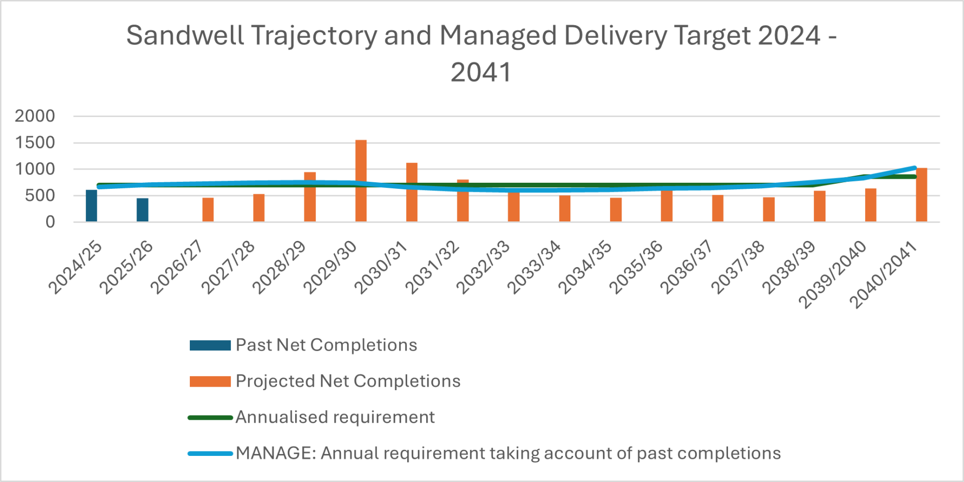
7.4 The council has identified sufficient land to provide 11,901 additional homes by 2041. The NPPF requires the Council to maintain a five-year supply of housing sites. On adoption of the plan (2026), based on the projected completions in the trajectory (see Appendix G), there is a 5.10 year supply (with a 20% buffer).97%....
Reason
Page / paragraph / policy reference
Paragraph 7.5
Proposed change
Amend text:
The details of proposed housing allocations are provided in Appendix B Chapters 16 and 17 and sites are shown on the Policies Map. Housing capacity has been identified in accordance with the Spatial Strategy and is based on the following information….
Reason
Page / paragraph / policy reference
Paragraph 7.6 – 7.9
Proposed change
Delete paragraphs:
7.6 The housing supply from allocations on occupied employment land has been discounted by 15% to take account of the multiple delivery constraints that typically affect such sites and that are likely to reduce delivery on a minority of sites. Delivery constraints include poor ground conditions and the need for large-scale master-planning, land assembly, business relocations and residential service access improvements.
7.7 The supply from other commitments in the current supply and allocated in the urban area has also been discounted by 10% to allow for non-implementation, as some of these sites are also affected by delivery constraints such as poor ground conditions.
7.8 The supply from sites with planning permission but not yet under construction has been discounted by 5% in accordance with historic lapse rates. These discounts are balanced rates that take account of the likely availability of external funding to address constraints, as set out in the Viability and Delivery Study.
7.9 Together, these discounts provide sufficient flexibility in the housing land supply to meet any unforeseen circumstances.
Reason
Page / paragraph / policy reference
paragraph 7.11
Proposed change
Amend text:
The Plan period has been divided into four phases, covering every five years from 2024. Housing targets for each phase are provided in Table 5 7 details the housing land supply for the plan period. An indicative annualised delivery timeline is set out in the trajectory in Appendix G These are based on the housing trajectory set out in Appendix I, with further detail provided in the SHLAA. The trajectory demonstrates a steady supply of housing completions over the Plan period, justifying consistent housing targets throughout the Plan period. As set out in the NPPF (paragraph 76), the Council is seeking to confirm through the SLP the existence of a five - year housing land supply from the year of adoption (20256). For this purpose, the buffer applied to housing supply (as set out in the housing trajectory) will be 20%, in line with the most recent Housing Delivery Test results (2023).
Reason
Page / paragraph / policy reference
Appendix I (now Appendix G)
Proposed change
Replace current trajectory graph in Appendix I with new table and graph:

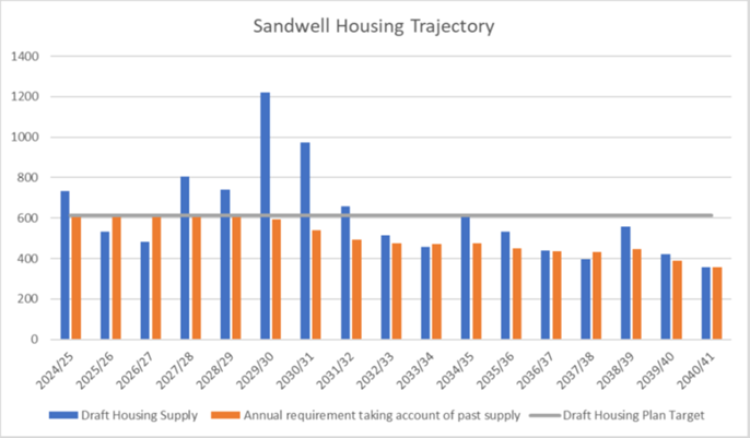
| 2025/26 | 2026/27 | 2027/28 | 2028/29 | 2029/30 | 2030/31 | 2031/32 | 2032/33 | 2033/34 | 2034/35 | 2035/36 | 2036/37 | 2037/38 | 2038/39 | 2039/40 | Total | |
|---|---|---|---|---|---|---|---|---|---|---|---|---|---|---|---|---|
| Total Housing Supply | 455 | 463 | 535 | 944 | 1555 | 1120 | 807 | 601 | 504 | 464 | 603 | 511 | 468 | 594 | 635 | 11,286 |
| 5 year supply | 3952 | 4617 | 4961 | 5027 | 4587 | 3496 | 2979 | 2683 | 2550 | 2640 | 2811 | 3235 | 2724 | 2256 | 1662 | 1027 |
| Rolling 5 year supply | 4.36 | 5.10 | 5.48 | 5.55 | 5.06 | 3.86 | 3.29 | 2.96 | 2.81 | 2.91 | 3.10 | 3.57 | 3.01 | 2.49 | 1.83 | 1.13 |
| Annualised requirement | 906 | |||||||||||||||
Reason
Update following hearing session
MM36
Page / paragraph / policy reference
SHO2 View responses
Proposed change
Amend policy wording.
1. Proposals for residential development on sites not specifically allocated for residential use (windfall developments) will be permitted where development on the site is previously developed land and in accordance with other local plan policies.
2. Proposals for residential development on unallocated greenfield land will be resisted. Such sites will only be considered where:
a) The site is not protected open space: or
b) The site is council owned land that is deemed surplus to requirements: or
c) the development of the site will bring an underused piece of land back into beneficial use and will not harm the environmental or ecological value of the site and the wider area, in accordance with other relevant policies in the SLP, or cause harm to the significance of heritage assets, including their setting.
3. All new developments should be supported by the necessary on and off-site infrastructure to serve its needs, mitigate its impacts on the environment and the local community, and ensure that it is sustainable and contributes to the proper planning of the wider area.
Reason
Clarification
Page / paragraph / policy reference
Para 7.13
Proposed change
Delete last sentence:
However, greenfield proposals will only be considered if they meet the criteria above.
Reason
MM37
Page / paragraph / policy reference
SHO3.1
Proposed change
Amend text:
Except where provided for in a site allocations policy, the density and type of new housing …
Reason
To reflect allocation policies that have specific density criteria
Page / paragraph / policy reference
SHO3.3
Proposed change
Amend text:
All developments of ten homes or more should achieve the minimum net density, on the net developable area, set out below, except where this would prejudice historic character and local distinctiveness as defined in Policy SHE2 …
Reason
Page / paragraph / policy reference
SHO3.3a. i
Proposed change
Add ‘or’ at the end:
i. located within a Strategic or Town Centre detailed at Table 10; or
Reason
Page / paragraph / policy reference
SHO3.4
Proposed change
Amend text:
4. Table 6 provides details of the appropriate density and, where appropriate, house type mix, to be sought on each housing allocation and any windfall site, in accordance with …
Reason
Page / paragraph / policy reference
SHO3.5
Proposed change
Amend text:
5. Any development that fails to make efficient use of land, by proposing developments where more than half of the proposed homes would have providing a disproportionate number of large, 4+ bedrooms homes when compared with evidenced local housing need, will be refused in accordance with the requirements of this policy.
larification
Reason
Page / paragraph / policy reference
SHO3.6
Proposed change
Delete.:
6. Development proposals should be consistent with other Local Plan policies.
Reason
Page / paragraph / policy reference
Paragraph 7.23
Proposed change
Amend text:
… Therefore, developments that fail to make the most efficient use of land by proposing developments of schemes where more than half of the proposed homes would have 4+ bedrooms homes when compared with evidenced local housing need, will be refused in accordance with the requirements of this policy and Policy SHO1.
Reason
MM38
Page / paragraph / policy reference
SHO4.2
Proposed change
Amend text:
… Smaller sites, which could reasonably be expected to form part of a major development in the future, will also need to take this policy into account. The minimum proportion of affordable housing that should be provided, subject to financial viability, is……
Reason
Clarification
Page / paragraph / policy reference
Paragraphs 7.26 – 7.27
Proposed change
Add supporting text to explain how to assess whether financial viability exceptions should apply:
7.26 The Viability and Delivery study demonstrates that viability varies greatly according to local housing values and whether the site is greenfield or brownfield. Therefore, a sliding scale of affordable housing requirements, ranging from 10% to 25%, has been set out in Policy SHO4, which reflects this variation. The affordable housing value zones
…
Therefore, to maximise delivery of affordable housing over the Plan period, it is important that affordable housing is sought on all eligible sites, that viability is assessed on a site-by-site basis where required, and that a flexible approach is employed wherever possible to allow for changing market conditions. The onus will be on the applicant to demonstrate that the provision of the required affordable housing would adversely affect the financial viability of the development proposals. Policy SID1 details steps that need to be taken to demonstrate viability issues.
7.27 The Council recognises that exceptional circumstances may sometimes occur where the combined costs of development, including abnormal site conditions, infrastructure, or other planning obligations, would render a scheme unviable if the full affordable housing requirement were applied. In such cases, the applicant will be required to submit a site-specific Financial Viability Assessment (FVA) in accordance with current national guidance. The FVA must provide transparent and robust evidence of all relevant costs, values, and assumptions, including land value, build costs, profit levels, and sales values, and must be supported by appropriate market evidence.
7.28 The Council will arrange for any submitted FVA to be independently reviewed, with the cost of the review met by the applicant. The assessment and its findings will be made publicly available, subject to the protection of any genuinely commercially sensitive information. The Council will seek to secure the maximum proportion of affordable housing on a case-by-case basis.
7.29 Where appropriate, review mechanisms will be used to reassess viability at agreed stages of delivery, ensuring that additional affordable housing contributions can be secured if market conditions improve. This approach ensures that flexibility is applied transparently, maintains confidence in the planning process, and delivers the greatest possible contribution to meeting Sandwell’s affordable housing needs.
7.27 7.30 The current affordable housing value zones …
Reason
Page / paragraph / policy reference
SHO4.2a
Proposed change
Amend text:
a. On all sites in a lower zones and brownfield sites in medium value areas zones – 10% affordable housing;
b. On greenfield sites in medium value zones – 15% affordable housing;
c. b. On all sites in higher…
Reason
Page / paragraph / policy reference
SHO4.3
Proposed change
Delete text:
3. 25% of the affordable homes required by this policy will be First Homes tenure, as defined in national guidance. First Homes will be provided in accordance with national policy.
Reason
Page / paragraph / policy reference
paragraph 7.31
Proposed change
Delete paragraph – policy now refers to requirements in national policy
The tenure of affordable housing to be funded by developers through planning obligations is constrained by national planning policy, as set out above. At least 25% of any affordable homes funded should be First Homes tenure – a specific kind of discounted market sale housing to be sold at 30% below current market value, to eligible persons only, at every future sale163. National guidance allows for evidenced local variations in First Homes requirements, however there is no evidence that such variations are required in Sandwell. In addition, the NPPF (paragraph 66) requires at least 10% of all homes on major developments (of ten homes or more) to be affordable home ownership tenure. Annex 2 of the NPPF provides a definition of affordable home ownership164.
Reason
Page / paragraph / policy reference
SHO4.6
Proposed change
Delete criterion 6:
6. The affordable housing created will remain affordable in perpetuity.
Reason
MM39
Page / paragraph / policy reference
SHO5.1
Proposed change
Amend text:
1. All new homes will be required to meet M4(2) (Category 2: Accessible and adaptable dwellings) requirement in Building Regulations except where site specific factors such as vulnerability to flooding, site topography, and other circumstances may make a specific site less suitable for M4(2).
Reason
Clarification
Page / paragraph / policy reference
SHO5.2
Proposed change
Amend text:
…(defined as the number of entries added to the self-build and custom build register in the most recent base period for the local authority ward where the site is located),
Reason
Page / paragraph / policy reference
Paragraph 7.41
Proposed change
Clarify text:
7.41 Therefore, wWhere there is identified demand in the borough, this will be assessed on a ward basis and by the number of people registered on the self-build and custom build register in the ward where development is proposed. When an application is submitted… . will be provided where appropriate. Where there is no evidence of demand, i.e. the Sandwell self and custom build register does not have any names registered for the ward in which the development is proposed, then the applicant will not have to provide self-build / custom build plots in the proposed development.
Reason
MM40
Page / paragraph / policy reference
Paragraph 7.44
Proposed change
- Add footnote:
Protecting Family Housingx
XFamily housing is a self-contained dwelling that is intended for one family or household and has two or more bedrooms.
Reason
Clarification
MM41
Page / paragraph / policy reference
SHO7.1
Proposed change
Clarification and additional footnote:
1. Proposals for the creation of a House in Multiple Occupation (HMO), including the conversion of buildings or sub-division of dwellings, will only be permitted if this would not result in over 10% of the number of residential properties171 within a 100-metre radius of the application site, measured from the centre point address point* of the property (referred to in this policy as the “relevant area”) operating as HMOs and if the proposals would meet the additional criteria set out in this policy.
*The location of an address point is recorded on the Local Land and Property Gazetteer (LLPG) which is managed by Sandwell Council.
Reason
Clarification
Page / paragraph / policy reference
SHO7.3
Proposed change
Correct reference:
a. the development would not:
i. result in the loss of C3 family-sized dwellings in areas where there is a proven demand for such accommodation (Policy SHO76);
Reason
Page / paragraph / policy reference
Paragraph 7.53
Proposed change
Add supporting text to make it clear that this policy applies to large HMOs, and after the introduction of an Article 4 direction:
7.53 Houses in multiple occupation (HMOs) are defined as homes accommodating three or more unrelated households who typically share kitchens, lounges, and bathrooms. If an Article 4 direction is put in place, which means that the council has removed "permitted development rights,” planning permission will be required for small HMOs (3 – 6 people) in specific areas.
Reason
MM42
Page / paragraph / policy reference
SHO8.2 (c)
Proposed change
Amend text:
For sites where there is likely to be a requirement for on-site provision of new schools, this is set out in Appendix B Chapters 16 and 17.
Reason
Clarification and update
MM43
Page / paragraph / policy reference
SHO9.2
Proposed change
Amend as follows:
2. Table 11 sets out the need for new Gypsy and Traveller permanent pitches and Travelling Showpeople plots will be provided to meet identified needs up to 2031 as set out in Table 9, in accordance with the Black Country Gypsy and Traveller Accommodation Assessment (GTAA) 2022.
Insert table:
Table 11: Need and Supply of Gypsy and Traveller Permanent Pitches and Travelling Showpeople Plots
| Type of Supply | Proposed Supply (Allocations) | Need to 2031 | Need 2031 -2041 | Total Need | Shortfall |
|---|---|---|---|---|---|
| Gypsy and Travellers (Pitches) | 10 | 12 | 6 | 18 | 8 |
| Travelling Showpeople (Plots) | 0 | 24 | 8 | 32 | 32 |
Reason
Clarification and update
Page / paragraph / policy reference
SHO9.4f
Proposed change
Delete reference to BNG from list of criteria:
… e. … drainage, sewage and waste disposal (storage and collection);
f. a minimum 10% biodiversity net gain is demonstrated in accordance with Policy SNE2; and
g. f. the site should not be at risk of flooding
Reason
Page / paragraph / policy reference
Paragraph 7.71
Proposed change
Amend text:
A Gypsy and Traveller Accommodation Assessment (GTAA) for the Black Country was completed in 2022, in accordance with national guidance, and identified the likely future local need for Gypsy and Traveller and Travelling Showpeople accommodation. Table 9 demonstrates that the Council cannot provide a 5-year supply for Gypsy and Traveller pitches, It is anticipated that allocations and permissions will provide sufficient supply to meet targets up to 2031, and sSmall windfalls within the urban area are expected to meet remaining need over the Plan period. …
Reason
Page / paragraph / policy reference
Paragraph 7.75
Proposed change
Amend text:
The SLP aims to meet the needs of existing families that meet the Planning Policy for Travellers Sites 2015 2024 (PPTS) travel for all definition (excluding those living in bricks and mortar accommodation) as identified in the GTAA as ‘ethnic identity’, by continuing to deliver privately and publicly owned sites and pitches. The total need identified is for eight twelve pitches up to 2031, and an additional six pitches from 2031 to 2041, totalling 18 pitches across the plan period. The Plan has allocated one site with ten pitches, so has a shortfall of eight pitches across the plan period.
Reason
Page / paragraph / policy reference
Paragraph 7.76
Proposed change
Delete Table 9
Table 9 - Supply of Gypsy and Traveller Permanent Pitches up to 2031
| Type of Supply | Number |
|---|---|
| Existing authorised pitches | 16 |
| Regularise temporary / unauthorised sites (b) | 0 |
| Intensify and extend existing sites (c) | 0 |
| Pitch allocations (d, e) | 10 |
| Total New Pitches | 10 |
Reason
Update – see related modifications
Page / paragraph / policy reference
Paragraph 7.77
Proposed change
Delete paragraph:
Table 9 demonstrates how this approach will deliver sufficient pitches to meet the need up to 2031 plus a buffer of two pitches (20%) - providing a five-year deliverable supply of pitches from adoption of the SLP in 2025, as required by the PPTS. The approach will also provide 71% of the total need for 14 pitches over the Plan period (2024-41).
Reason
Page / paragraph / policy reference
Paragraph 7.78
Proposed change
Amend text:
It is not possible to identify and allocate further sites to meet the remaining need for four eight pitches up to 2041, as no deliverable site options were put forward through the Sandwell Local Plan preparation process …
Reason
MM44
Page / paragraph / policy reference
SHO10
Proposed change
Amend title:
Policy SHO10 - Housing for people with specific needs requirements
Reason
Clarification
Page / paragraph / policy reference
SHO10.1 View responses
Proposed change
Amend as follows:
1. Proposals for specific forms of housing including children’s homes, care homes, nursing homes, extra care facilities. housing for older people, or any other identified need, will be considered in relation to the following criteria:
a. the type of specialist accommodation proposed meets identified needs;
b. compatibility with adjacent uses;
…
h. proximity to facilities;
i. the proposal meets the accessibility requirements set out in Policy SHO5.
Reason
Page / paragraph / policy reference
SHO10 Para 7.82 View responses
Proposed change
Include the level of need for older persons accommodation:
To plan effectively for people with specific needs, the Council will develop a series of strategies to help meet these needs177, which will be implemented over the Plan period. The Strategic Housing Market Assessment 2024 identified a requirement for 1,708 additional units of sheltered housing for older people / retirement housing and 378 additional extra care units / supported living housing in Sandwell over the plan period.
Reason
MM45
Page / paragraph / policy reference
SEC1.2a
Proposed change
Amend text:
2. The borough is subject to a demand for 211 229.5 hectares of new employment land (based on the past trends forecast of 185 203.5 hectares and accounting for the loss of employment land of 26 hectares to non-employment uses), between 2020 and 2041. This will be delivered through:
a)The development of employment development sites allocated in the Plan, equal to 42 44.5 hectares (this figure includes past completions since 2020).
Reason
Update figure
Page / paragraph / policy reference
SEC1.3
Proposed change
Amend text:
The Plan will deliver a portfolio of employment development sites of various sizes and quality to meet a range of business needs. This land is The employment development sites, in addition to those sites currently occupied for employment uses purposes under Policies SEC2, SEC3 and SEC4, These sites will be safeguarded for industrial employment uses uses under Use Classes E(g)(ii), E(g)(iii), B2, and B8.
Reason
Page / paragraph / policy reference
SEC1.4 View responses
Proposed change
Amend text:
… the Council will support, with public intervention as necessary, the regeneration and renewal of such areas, including their environmental enhancement, the protection and enhancement of heritage significance where it occurs and the incorporation of sustainable measures to mitigate climate change impacts. …
Reason
MM46
Page / paragraph / policy reference
SEC4.2b
Proposed change
Amend text:
… if the site is occupied or part-occupied, that successful engagement has been undertaken with the occupiers to secure their relocation and the site has been genuinely marketed for employment use for a period of at least 12 months.
Reason
Clarify that occupied sites will also undergo marketing as described in criterion 2a
MM47
Page / paragraph / policy reference
SEC6 Paragraphs 8.50 – 8.51
Proposed change
Add new paragraph between paragraphs 8.50 – 8.51 and renumber remaining paragraphs:
8.50 … by the businesses operating in these areas.
8.51 In this context, it is recognized that some existing industrial or commercial uses may cause significant nuisance or harm to neighbouring residential areas. While the complete removal of these ‘bad neighbours’ may not always be feasible or desirable due to economic and employment considerations, the Council would support proposals that seek to replace them with less harmful neighbours - businesses or uses that have a reduced impact on adjacent sensitive uses such as housing. This approach aims to balance the protection of residents from harmful impacts with the need to maintain a viable local economy, ultimately fostering a more sustainable coexistence between employment land and sensitive residential areas.
8.51 8.52 Equally, given pressure on older …
Reason
Clarification - explain Council would support the replacement of a bad neighbour by a ‘less harmful’ neighbour.
MM48
Page / paragraph / policy reference
SCE1.6b
Proposed change
Amend text:
b. the consolidation and reconfiguration of vacant floorspace into a mix of uses, especially the residential use of upper floors where appropriate, and / or extensions to existing floorspace, with any new development being well-integrated with existing provision;
Reason
Clarification
Page / paragraph / policy reference
SCE1 View responses
Proposed change
Add new criterion:
… 6d ... coverage where appropriate.
7. Proposals should recognise, protect and make use of heritage assets so that they can contribute to environmental, economic and community regeneration consistent with their status, securing their long-term viability through sensitive repair, restoration, and adaptive reuse.
Proposals will be supported where they protect and enhance heritage significance, contribute to town centre vitality, and deliver public benefits that outweigh any potential harm.
Reason
Page / paragraph / policy reference
Table 10.
Proposed change
Amend heading at end of first column and include Abbey Road and Hagley Road West in alphabetical list:
Proposed local centres:
Update the rest of the plan for consistency.
Reason
MM49
Page / paragraph / policy reference
SCE2
Proposed change
Consistent references to Primary Shopping Area, delete reference to Retail Core:
- The
Retail Core /Primary Shopping Areas within the centres of Sandwell are defined on the Policies Map. - To ensure that uses defined by Use Class E (commercial, business and services194) remain the predominant uses within the defined
retail core /primary shopping areas… - Changes of use of ground floor premises that require planning consent in
Retail Core /Primary Shopping Areas will be assessed… - In centres with no defined
retail core orPrimary Shopping Area, proposals for….
Make consequential updates to town centre plans in SLP to reflect changes to designations.
Reason
Update and consistency
MM50
Page / paragraph / policy reference
SCE4.1
Proposed change
Amend text:
Proposals for appropriate uses (paragraphs 9.68 – 9.71 9.70) … (in-centre locations being defined in paragraph 9.67a 9.70) … catchment areas of those centres. In addition, the residential reuse of upper floors will be considered positively where appropriate.
Reason
Clarification
Page / paragraph / policy reference
Paragraphs 9.42 – 9.44
Proposed change
Delete text:
9.42 A new local centre has been designated on Hagley Road West (Hollybush). Its designation corrects an anomaly. This centre includes 37 commercial units providing convenience and comparison outlets, food outlets, financial services, grooming and health services, some of which are double fronted. Until comparatively recently it had no convenience offer. This has since changed, hence its eligibility for inclusion as a centre. It is located on the boundary between Sandwell and Birmingham City Council, with further commercial units in Birmingham; functionally it is significantly larger than several existing Sandwell Tier-Three centres. It has been monitored annually for several years. The review of the Local Plan is the correct time to incorporate it into the hierarchy of centres.
9.43 Another new centre, Abbey Road Local Centre, is proposed at the junction of Wigorn Road and Abbey Road, Smethwick. Its designation corrects an anomaly. This centre comprises 24 commercial units including a post office, food outlets, grooming and health services. It also has a long-standing convenience offer. It also has a long-standing convenience offer. Functionally, it is larger than several existing Sandwell Tier Three centres. The review of the Local Plan is the correct time to incorporate it into the Hierarchy of Centres.
9.44 The former Tier-Three centre located at the junction of Hagley Road and the A4123 (known as Hagley Road / Jonathan’s) has been removed from the Hierarchy of Centres as it no longer fulfils the function of a local centre, having lost most of its functions since it was first identified, including the key convenience aspect of its offer.
Reason
MM51
Page / paragraph / policy reference
SWB1.2 View responses
Proposed change
Add criterion:
2.j conserving and enhancing the historic environment (Policies SHE1 – SHE4).
Reason
Soundness
Page / paragraph / policy reference
Paragraphs 10.24 – 10.25 Table 11
Proposed change
Amend tables to delete references to undiscounted housing figures in columns headed Indicative Land Use
Reason
MM52
Page / paragraph / policy reference
SWB2.1a
Proposed change
Amend text:
Residential provision will be maximised, to increase and strengthen communities, with indicative housing capacity identified by the West Bromwich Masterplan and West Bromwich Inset, providing a minimum of 1,162 1,536 new homes in the strategic centre by 2041.
Reason
Clarification
Page / paragraph / policy reference
Paragraph 10.41 Figure 13
Proposed change
Amend and update text:
The strategic centre boundary and Primary Shopping Area are is identified on the Policies Map and shown at Figure 13. It is They are used for determining what is in and out-of-scope in terms of proposals. Plan of Wednesbury Town Centre to be replaced with one of West Bromwich Town Centre (see AM61)
Reason
Update and consistency
Correction
MM53
Page / paragraph / policy reference
Paragraph 11.4 Figure 14
Proposed change
Amend Figure 14:
Existing Transport Network Map
- The plan is missing the current cross-city route from Smethwick (near Rolfe Street Railway Station), through Cape Hill, towards Birmingham (serving buses 54, 82 and 87) and this should be added to the plan.
Reason
Corrections
Page / paragraph / policy reference
STR1 Figure 16
Proposed change
Amend Figure 16:
- The plan is missing the current cross-city route from Smethwick (near Rolfe Street Railway Station), through Cape Hill, towards Birmingham (serving buses 54, 82 and 87) and this should be added to the plan.
- The plan shows a route along the A457 Tollhouse Way / Soho Way and then along the B4135 Cranford Street / Heath Street; however, there are no bus services along this route, which should be amended.
- The route along Hamstead Road should continue up to the A4041 Newton Road Core Bus Network - replace map with amended version
Reason
MM54
Page / paragraph / policy reference
Paragraph 11.27
Proposed change
Amend text:
… by rapid transit and core bus routes (the West Midlands Core Bus Network as shown on Figure 14 or as amended from time to time)…
Reason
Correction and update
MM55
Page / paragraph / policy reference
STR2 Paragraph 11.28
Proposed change
Amend text:
… in consultation with neighbouring highway authorities. Since 2025, the power to alter the KRN has been devolved to the WMCA Mayor. All policies relating to the KRN will apply to the network as amended from time to time. The KRN features …
Reason
Clarify role of WM Mayor
MM56
Page / paragraph / policy reference
STR4.5
Proposed change
Amend text:
Existing and disused railway lines and sidings, and any that become disused in the future, will be safeguarded for rail-related use
Reason
Clarification
MM57
Page / paragraph / policy reference
STR5 Paragraph 11.51 View responses
Proposed change
Amend text:
All new cycle facilities will be designed in accordance with guidance set out in Local Transport Note 1/20 and TfWM’s Cycle Design Guidance. Where cycle routes and associated facilities are located in areas of heritage, archaeological or ecological sensitivity, their design should take this into account.
Reason
Clarification
MM58
Page / paragraph / policy reference
STR9 .1d
Proposed change
Correction:
… such as hydrogen fuel cells …
Reason
Correction to wording
MM59
Page / paragraph / policy reference
SID1.1
Proposed change
Amend text:
- All new developments should be supported by the necessary on and off-site infrastructure to serve its needs, mitigate its impacts
on the environment and the local community, and ensure that it is sustainable and contributes to the proper planning of the wider area.
Reason
Clarification
Page / paragraph / policy reference
SID1.3
Proposed change
Amend text:
- A planning application that complies with up-to-date policies within this plan will be assumed to be viable and should
seek toprovide any relevant planning contributions necessary to make it acceptable in planning terms.The onus will be on the applicant to demonstrate that the provision of planning contributions would adversely affect the financial viability of the development proposals.
Reason
Page / paragraph / policy reference
SID1.4
Proposed change
Add wording:
Where an applicant submits a planning application that seeks to make a reduced planning contribution on viability grounds, financial viability assessments conforming to national guidance will be required to be submitted prior to determination and, where necessary independently appraised by an appropriate professional appointed by the local planning authority at the cost of the applicant. The onus will be on the applicant to demonstrate that the provision of planning contributions would adversely affect the financial viability of the development proposals.
Reason
Page / paragraph / policy reference
SID1.5
Proposed change
Amend text:
5. Any viability assessment should be prepared on the basis that it will be made publicly available other than in exceptional circumstances, and in such circumstances an executive summary will be made publicly available.
Reason
Page / paragraph / policy reference
SID1.7
Proposed change
Amend text:
7. Sandwell Council will set out in an Infrastructure Delivery Plan (to be reviewed annually):
Reason
MM60
Page / paragraph / policy reference
Paragraph 12.17 View responses
Proposed change
Amend text – refer to emergency services:
j) Public services including emergency facilities.
Reason
Clarification
MM61
Page / paragraph / policy reference
SID2
Proposed change
Amend text:
5G, 6G and Future Digital Networks
…
- Any proposals for infrastructure to support the delivery of 5G and future, more advanced, digital networks will be supported in principle
…
- Operators proposing 5G and future, more advanced, digital network infrastructure are strongly recommended to enter early discussions with the Council.
Reason
Update
MM62
Page / paragraph / policy reference
Glossary Appendix O (now Appendix N) View responses
Proposed change
Modify definition of infrastructure:
Basic services necessary for development to take place, e.g., roads, electricity, sewerage, water, education, and health facilities, andpublic service infrastructure and facilities (including emergency services).
Reason
Update
MM63
Page / paragraph / policy reference
SWA2.1 View responses
Proposed change
Amend text:
Sandwell will safeguard all existing strategic and other waste management facilities from inappropriate incompatible development to maintain existing maximum levels of waste management capacity and meet Strategic Objective 17, unless it can be demonstrated that…
Reason
Clarification
MM64
Page / paragraph / policy reference
Paragraph 13.41
Proposed change
Amend first sentence:
13.41 When determining applications for non-waste development within a short distance of or adjacent to an existing waste management facility, regard will be had to any potential adverse impacts the proposed development might have on the future of the site as a location for the continuation of waste management activities in accordance with the ‘agent of change’ principle.
Reason
Align with the NPPF and the ‘Agent of Change Principle’.
MM65
Page / paragraph / policy reference
SWA4.3 and 4.4 Paragraphs 13.68 – 13.71
Proposed change
Delete criteria SWA4.3 and 4.4:
Waste Applications – Supporting Information
3. Planning applications for waste development[232] should include a supporting statement that clearly describes the key characteristics of the development. It should also explain how the development aligns with Strategic Objective 17 and the General Principles and Preferred Methods of managing waste in Policy SWA1. In particular, the application should explain the contribution the development would make towards driving waste up the waste hierarchy, supporting the development of a more circular economy, meeting the Black Country's additional waste capacity requirements, and broadening the range of waste facilities currently available in the plan area.
4. The following information should also be included in the supporting statement and / or on the planning application form:
a. the type of waste facility or facilities proposed;
b. the waste streams and types of waste to be managed;
c. the types of operation to be carried out on the site;
d. whether waste would be sourced locally, regionally or nationally;
e. the maximum operational throughput in tonnes per annum;
f. for waste disposal, the total void space to be infilled in cubic metres;
g. the outputs from the operations, including waste residues;
h. the expected fate and destination of the outputs;
i. the number of associated vehicular movements;
j. the number of jobs created.
Move deleted text into justification text at paragraphs 13.68 - 13.71; redraft to avoid duplication:
13.70 To assist applicants, the policy sets out the key pieces of information they should provide to enable the Council to understand the types of operation proposed and the potential effects of the development on the environment and on the health, wellbeing and amenity of people living or working near the site. This information should be collated together into the summary included in the supporting statement.
13.71 The most appropriate place to set out, describe in detail and assess such a proposal against relevant planning policies is within a Planning Statement. In addition, if the development requires an Environmental Impact Assessment (as it represents Schedule 1 or 2 development), details should be included in an Environmental Statement. The following information should also be included in the supporting statement and / or on the planning application form:
- the type of waste facility or facilities proposed;
- the waste streams and types of waste to be managed;
- the types of operation to be carried out on the site;
- whether waste would be sourced locally, regionally or nationally;
- the maximum operational throughput in tonnes per annum;
- for waste disposal, the total void space to be infilled in cubic metres;
- the outputs from the operations, including waste residues;
- the expected fate and destination of the outputs;
- the number of associated vehicular movements;
- the number of jobs created.
Reason
Remove from the policy into supporting text - considered to be supporting information to the policy.
MM66
Page / paragraph / policy reference
Paragraph 13.94
Proposed change
Explain where sand and gravel will be imported from:
...It is therefore unlikely that Solihull will be able to sustain the same rates of sand and gravel sales seen over the last ten years, at least in the short-term until new sites come forward. The latest information available shows that Staffordshire is by far the largest producer of sand and gravel in the West Midlands region and is the main source of imports to the West Midlands Metropolitan Area.
Reason
Clarification
MM67
Page / paragraph / policy reference
SMI2.3 Appendix O (now Appendix N)
Proposed change
Add text:
… planning permission will be granted for built development within the Limestone Consideration Zones …
Add the following to the Glossary:
Limestone Consideration Zones – These have been defined around areas that would be seriously affected by surface subsidence in the event of the collapse of an abandoned limestone mine. If new development is to be allowed within a Consideration Zone, the developer will be required to demonstrate that a collapse in the mine would not prejudice public safety or compromise the structural integrity of the proposed structures.
Reason
Clarification
MM68
Page / paragraph / policy reference
SCO3.
Proposed change
Update footnote references to NPPF Dec 2023:
240 NPPF (2021) paragraph 174, section (e) NPPF (2023) paragraph 180, section (e)
248NPPF (2021) paragraph 174, section (e)NPPF (2023) paragraph 180, section (e)
249 NPPF (2021) paragraph 174, section (f)NPPF (2023) paragraph 180, section (f)
251 https://mapapps2.bgs.ac.uk/coalauthority/home.html https://datamine-cauk.hub.arcgis.com/
Reason
Correction
Refer to 2023 NPPF for consistency.
URL has been updated.
MM69
Page / paragraph / policy reference
SDM1.1h
Proposed change
Remove policy reference from criterion 1h:
h. the presence of canals in Sandwell’s urban environments and the opportunities they offer for design, accessibility, the environment and technology (Policy SNE6);
Reason
Delete anomalous reference for clarity.
Page / paragraph / policy reference
SDM1.2
Proposed change
Amend text:
… and where appropriate used to inform design and access statements and site-specific design codes (where agreed with the Council) that reflect their Sandwell-specific context…
Reason
Page / paragraph / policy reference
SDM1.3
Proposed change
Amend text:
Major development proposals should contribute to the greening of Sandwell by demonstrate that the following opportunities have been considered and where appropriate been used to inform the design: …
Reason
Page / paragraph / policy reference
Paragraph 15.14
Proposed change
Include in supporting text:
15.14 To ensure that development proposals accord with policy requirements, the Design and Access Statements accompanying planning applications should follow the Government’s guidance, “Making an application” (2014) (updated 2021).
15.15 The following table sets out a list of policies that are cross-referenced against criteria a to j of part 1 of the policy. This is intended to provide a useful starting point for members of the public and developers who want to understand what policies might apply to schemes that are being proposed. This is not a closed list, and other SLP policies will also apply where appropriate.&
| Policy section | Other policies in SLP |
|---|---|
| a. the topography, townscapes and landscapes of Sandwell; | SDS5, SDS8, SNE1 – SNE6, SHE1 – SHE4, SHW4 |
| b. the need to maintain strategic gaps and views, including to and from the Rowley Hills; | SDS5, SDS7, SDS8, SNE5, SHW4 |
| c. the built and natural settings of development; | SDS8, SNE1 – SNE6, SHE1 – SHE4 |
| d. the need to ensure that domestic extensions should generally be subservient and proportionate to the existing dwelling and should be in keeping with their surroundings by virtue of their scale, architecture and materials. | SDS5, SHE1 – SHE4 (where relevant), SHO7, SHO10, SDM2 |
| e. the treatment of ‘gateway’ opportunities where they occur in key locations; | SDS5, SDS8, SNE3 |
| f. Sandwell’s industrial and domestic architecture; | SDM2, SDM3 |
| g. the need to ensure development has no harmful impacts on key environmental and heritage assets, townscapes and locations and that wherever possible it contributes to the conservation and enhancement of environmental and heritage assets and their settings; | SDS2, SDS8, SNE1 – SNE6, SHE1 – SHE4, SDM3 – SDM5 |
| h. the presence of canals in Sandwell’s urban environments and the opportunities they offer for design, accessibility, the environment and technology; | SDS8, SNE6, SHW4, STR5, SID2 |
| i. the matter of land instability where this is an issue in relation to specific development proposals; | SCO3 |
| j. the need to mitigate and adapt to the impacts of climate change in accordance with the relevant policies in the plan. | SDS2, SDS8, SCC1 – SCC6, SDM2 |
Reason
Clarification
Page / paragraph / policy reference
Paragraph 15.15 onwards View responses
Proposed change
Amend text to refer to situations where developers may want to use their own design codes:
15.15 15.16 Not all the guidance …as part of the proposal’s supporting information.
15.17 The Sandwell Design Code provides locally specific advice for everyone submitting a planning application on what standards and details the Council will be expecting from all new buildings in the borough. It sets out both primary requirements and additional guidance for all development proposals in Sandwell. If a situation arises where it is felt the code does not address a particular issue on a site that may be relevant to matters of design, proposals will be expected to reflect and evidence the most relevant and up-to-date national design guidance available, including the contents of the extant National Model Design Code, on how their proposals have addressed this issue.
15.18 As set out in Policy SDS5, schemes that do not use / comply with the Sandwell Design Code will be refused unless specific and convincing reasons can be provided for not doing so.
15.19 Where a developer wishes to utilise their own design code, their code must be agreed with the Council. Their approach must still accord with local design principles set out in the Sandwell Design Code and follow the process as set out in the National Model Design Code as appropriate, which includes the need to conduct evidenced community engagement prior to the code being agreed with the Council.
Reason
MM70 View responses
Page / paragraph / policy reference
SDM2.1 and new paragraph (15.26) View responses
Proposed change
Amend text to address other potential exceptions:
… except where it can be clearly evidenced that the implementation of the NDSS would cause harm to the significance of a heritage asset264, or the development proposes an innovative design for the construction of, or a change of use to, a small dwelling. Any other proposed departures from the NDSS standards, including for the conversion of former non-residential buildings such as from office blocks to apartments, will require robust and convincing justification to be demonstrated before a scheme will be approved.
New paragraph in justification:
15.26 All new-build dwellings will be expected to meet the NDSS, including apartments, as will the conversion of commercial, industrial or similar non-domestic buildings to provide residential accommodation. The policy identifies limited exceptions to this, allowing for an element of flexibility in certain circumstances:
- The successful conversion of a heritage asset to a dwelling will be dictated in some instances by the form the building takes, including through the retention of the structure as it was first constructed. This may in turn preclude the imposition of the NDSS in the interests of maintaining its significance.
- There may also be situations where a proposal for a purpose-built small house (often referred to as a tiny or micro home and typically having a floor area of 50m2 or less) would not deliver room sizes to match the NDSS. This offers flexibility in considering innovative designs that may come forward from individuals interested in developing such a property.
Reason
Clarification and justification
Page / paragraph / policy reference
SDM2.3 Paragraph 15.28 View responses
Proposed change
Amend policy and justification text:
4. New residential development (including conversions from non-residential properties) and houses in multiple occupation will be required to meet the water efficiency standard of 110 litres per person per day, as set out in Part G2 of current Building Regulations or as identified in any successor legislation. Developers are encouraged to implement higher water efficiency standards where possible.
15.28 … This change in water stress classification adds further weight to the need for a tighter water efficiency limit to be adopted; this will be enforced through the building regulations system. Where new water efficiency standards emerge during the plan period, they will be used in place of the one set out in the policy. Both Severn Trent and South Staffordshire Water currently offer incentives, overseen by Ofwat, that provide financial payments to developers who build homes that achieve lower water consumption levels such as 100 litres per person per day or less.
Reason
MM71 View responses
Page / paragraph / policy reference
SDM3.1 View responses
Proposed change
Amend text:
… including the need to have regard to the existing or emerging character and context of the area and should also take account of the requirements of the historic environment policies (SHE1 – SHE4) as appropriate.
Reason
Clarification and cross-reference
Page / paragraph / policy reference
SDM3.5g
Proposed change
Amend policy text; relocate to justification (paragraph 15.33):
… 5g. the proposal will integrate into its surroundings at all levels, particularly at street level and skyline.
Reason
Page / paragraph / policy reference
SDM3.6a
Proposed change
Amend to mention views and settings of the existing local skyline:
6a. key extant landmark buildings, structures and features will be preserved and improved; views of them and their settings will be protected as necessary;
Reason
Page / paragraph / policy reference
Paragraph 15.33 View responses
Proposed change
Amend text to clarify definition and renumber subsequent paragraphs accordingly:
15.32 This policy does not aim to hide tall buildings, but to ensure that they are located and designed to create a positive feature in the urban environment from all viewpoints.
15.33 It is important to understand what is meant by tall or taller buildings in a Sandwell-specific context. Most of the buildings in Sandwell are residential in nature and appearance, so in the wider borough there are relatively few examples of taller or tall buildings, except in certain locations. Some industrial, office and leisure buildings and telecommunication structures are key landmarks on the borough’s skyline, however.
15.34 Based on information from the emerging Sandwell Design Code: In most of Sandwell, building heights tend to be between one to three storeys, with the majority of residential properties being two storeys. In the regeneration areas identified in the SLP (Dudley Port and Tipton, Smethwick, Wednesbury and West Bromwich), there are concentrations of taller buildings of between three to four storeys. Some taller buildings (between three to four storeys) also stand close to the Metro and along other public transport corridors. In West Bromwich there are several buildings above five storeys in height, for example in Charlemont and Newton. There are other examples of residential towers exceeding eight storeys in height in various parts of the borough including at Windmill Lane (Smethwick), Whiteheath Gate (Oldbury), and Wallace Road (Tividale).
15.35 For the purposes of this policy, therefore, a taller building would be dependent on local context and location but is likely to be one or more storeys taller than the prevailing building height in the area. A tall building would be one located within West Bromwich, or in other town centre locations where appropriate, and may be over five storeys in height depending on its context and the adjacent morphology. Proposed buildings of this scale should:
- be designed to respond to their local setting and character,
- consider and address any potential impacts on areas or buildings of heritage significance, and
- be accompanied by a site-specific analysis, visual impact analysis and /or site design code, where agreed by the Council.
Include text relocated from policy:
15.33 15.36 In designing tall buildings, emphasis should be given …It may also be appropriate to set taller elements of the building back from the street frontage. Tall buildings will need to integrate into their surroundings at all points, particularly at street level and skyline. Should such a proposal potentially obscure parts of a skyline already containing landmark features / buildings, this will be taken into consideration when a decision is made.
Reason
MM72 View responses
Page / paragraph / policy reference
Paragraph 15.40 View responses
Proposed change
Amend text:
15.40 In conservation areas, advertising proposals will also be expected to demonstrate how they would conserve or enhance the character and appearance of the area, as required under Section 72 of the Planning (Listed Building and Conservation Areas) Act 1990 (see Policies SHE1 – SHE 4 for further guidance on proposals in the historic environment).
Reason
Cross-reference
MM73
Page / paragraph / policy reference
SDM5.2 and paragraph 15.45 View responses
Proposed change
Add criterion dealing with heritage assets in terms of both shop fronts and roller shutters. Add supporting text to explain LB consent needed for fitting roller blinds inside and outside the building. Emphasise the need to understand the significance of the building.
… 2h. whilst the appearance of a building should not be compromised, consideration should be given to natural surveillance, safety and security when designing new shop fronts.
- Where development proposals involve works to shopfronts or the installation of roller shutters affecting heritage assets, including Conservation Areas and Listed Buildings, the design and materials must conserve or enhance the asset’s significance and setting. Proposals should follow the guidance set out in Policies SHE1 - SHE4 and avoid visually intrusive or unsympathetic alterations that would harm the building’s architectural or historic character or that of the historic environment it lies within.
…
15.45 …..Well-designed roller shutters such as this will prevent the creation of a solid, unwelcoming appearance especially at night when most businesses are closed.
15.46 Heritage assets are an irreplaceable resource and should be conserved in a manner appropriate to their significance. Alterations to shopfronts and the installation of security features such as roller shutters can have a pronounced impact on the character and appearance of historic buildings and areas. Listed Building Consent will be required even for minor works, including the installation of internal or external roller blinds or shutters, where they affect the special architectural or historic interest of a listed building.
Reason
Clarification
MM74
Page / paragraph / policy reference
SDM6, SDM7 View responses
Proposed change
Combine into one policy:
Policy SDM6 - Hot Food Takeaways
I: In principle considerations
Vitality and Viability
- A percentage limit for the appropriate number of hot food takeaways in centres (strategic, town, district and local), including hot food takeaway permissions, and vacant units with a hot food takeaway as their lawful use is as follows:
- in centres with 40 retail units or more – no more than 7% of frontages should be occupied by hot food takeaways;
- in centres with less than 40 retail units – no more than 12% of the frontages should be occupied by hot food takeaways.
Clustering of hot food takeaways in centres.
- No more than two hot food takeaway outlets should be located next to each other. Any application for a further hot food takeaway use that would exceed this limit will not be permitted.
- Where two hot food takeaways are located next to each other, they should be separated from any new hot food takeaway unit by at least two non- hot food takeaway units.
Exclusion zones
- An exclusion zone will be implemented near to secondary schools and higher education establishments; no new hot food takeaway developments will be permitted where they are within 400 metres of a secondary school or college site (as measured in a straight line from the school entrance(s) used by pupils / students).
II: Detailed Matters
- Where the above requirements have been satisfied and the Hot Food Takeaway is acceptable in principle the following additional measures to protect the amenity of surrounding residential occupiers will apply:
Amenity
- No new hot food takeaways will be permitted where they are directly adjacent to residential property at ground floor level. This does not apply to first / second floor flats above or diagonally above a proposed hot food takeaway.
- Where there is an existing residential unit above a proposed hot food takeaway, which is not connected with its operation, private residential amenity should not be prejudiced. Specific attention will need to be given to odour extraction, noise insulation, private accessibility and public convenience. Appropriate mitigation measures will include control over hours of opening hours.
- Where appropriate provisions cannot be included then such uses will not be supported, even within designated centres.
Local environmental issues
- All hot food takeaways will require appropriate fume extraction equipment to be installed, retained and maintained to reduce / remove potential nuisance from odours. Extraction systems should be effective in dispersing odours from hot food takeaways, whilst satisfying the council’s design policies, especially in areas of historic character.
- Such systems should be insulated to a level sufficient to prevent any noise they make from creating adverse impacts for adjacent residents.
Disposal of waste products and litter
- Appropriate fat traps / interceptors must be installed on sinks and drains to prevent fat / oil from reaching the wastewater system, to avoid blockages and the subsequent flooding of property.
- Appropriate storage areas must be specified for food waste bins and packaging waste and be included in any new proposal.
- The bins to be provided must be a suitable size and should be stored in a location that will not cause a nuisance to neighbouring residential or commercial properties, including regarding odours and accessibility.
- Commercial bin stores must be contained within the site. Where this is not possible, secure storage structures should be provided, designed to prevent vermin infestation and reduce odours.
Management of Associated Impacts
- Proposals for new hot food takeaways will only be granted permission subject to planning conditions addressing matters such as (but not limited to):
- opening hours;
- parking restrictions;
- highway safety;
- where it is considered necessary, the installation of or contributions towards monitoring technology such as CCTV.
In some cases, approval may be limited to a personal permission and / or a temporary consent.
- In determining any planning applications for hot food takeaways, the Council will consider any issues concerning community safety, crime, and disorder and will, where necessary, seek advice from the police and other safety organisations.
Retain supporting text for both policies and repeat after amalgamated policy.
Delete extant introductory paragraph for former policy SDM7:
Management of Hot Food Takeaways
15.61 In addition to Policy SDM6, Policy SDM7 offers guidance on the requirements for the provision of hot food takeaways. Applicants wishing to provide or alter a hot food takeaway unit should ensure they address the issues raised in the policy, which is designed to manage adverse impacts on adjacent residents and properties.
Renumber remaining policies etc. accordingly.
Reason
Clarification and effectiveness
Update associated text and paragraph numbering accordingly
MM75
Page / paragraph / policy reference
SDM9.3 (now SDM8)
Proposed change
Amend text:
ConsiderationDevelopments will need to makewill be given to the need for theprovision forofcar parking in line with the requirements set out in Appendix I. Consideration will be given to lower levels of car parking contingent on a robust Transport Assessment or Transport Statement being provided, whichassociation with the development. Thiswillincludes an assessment of:
a. the proximity and availability of public transport facilities;…
Reason
Page / paragraph / policy reference
SDM9.4 (now SDM8)
Proposed change
Amend text:
4. Where a change of use is proposed, Cconsideration may also be given to the granting of planning permission for a limited period where concerns relating to an application are insufficient to warrant refusal.
Reason
Page / paragraph / policy reference
SDM9.6 (now SDM8)
Proposed change
Amend text:
Any proposal that would result in the loss of a public house, social / community club or similar use will be resisted unless there is an alternative venue that can meet similar needs within walking distance, or evidence is provided that the venue is no longer economically viable. This requirement applies equally to community venues that are currently open or that have been closed within the past five years. Lack of viability will need to be demonstrated through the submission of robust evidence. As set out elsewhere in this plan (Policy SDS6), prior to considering any application for its change of use or redevelopment the Council will require robust evidence to be submitted that demonstrates the owners / occupiers have sought to retain the premises in its current or a very similar use. This must include evidence that the facility has been actively and genuinely marketed for 6 – 12 months for its current use (dependant on the nature or complexity of that use or the building itself) and that there has been no interest in either the freehold or leasehold.
Include new criterion 7 to address loss of social and community uses / facilities:
7. The loss of a building identified as providing for local social, community, leisure or similar uses will be resisted unless it can be robustly demonstrated to the satisfaction of the Council that:
- All reasonable efforts have been made to retain the facility in its current use, including robust active and positive marketing over a minimum six-month period;
- It is no longer required for that specific use, and no alternative community use can be found for it;
- it is being replaced with a community facility of equivalent or better quality / capacity in the local area; or
- it is no longer viable or practical to retain the building and it cannot be adapted or improved to suit.
This requirement applies equally to community venues that are either still open or that have been closed within the past five years.
7 8 As part of the design of new community developments …
Reason
Page / paragraph / policy reference
Paragraphs 15.82 - 15.83
Proposed change
Include additional justification:
15.82 Public houses and community centres across Sandwell provide opportunities for social interaction as well as offering locations for the delivery of cultural events and activities. They are publicly accessible community venues and where possible should be retained and supported in their role as part of the social character of the borough. In accordance with NPPF paragraph 97,the loss of existing public houses, community facilities and services will only be permitted in exceptional circumstances, supported by robust evidence to justify the loss in accordance with the criteria set out above. This will help to ensure that all residents continue to have good access to the facilities and services they rely on. Public houses are a notable aspect of the urban and industrial fabric of the borough and are often of significant heritage and architectural merit, as well as serving a community function.
15.83 Community facilities, such as places of worship and banqueting suites, often create parking problems associated with their use, particularly in residential areas. High levels of on street or inappropriate parking is frequently encountered at particular times of day, or on particular days of the week. Special events, when larger numbers of user are experienced, can exacerbate this situation.
15.84 Therefore, car parking will be required in accordance with the guidance set out in Appendix I. Subject to robust evidence on predicted levels of generated non-car trips being provided through either a Transport Assessment or Transport Statement as appropriate, lower levels of car parking will be considered in sustainable locations such as near public transport hubs, railway stations and metro stops. Lower levels will also be considered in town centres where sufficient public car parking is available at suitable times without adverse impact on other existing uses.
Renumber subsequent paragraphs.
Reason
Page / paragraph / policy reference
Appendix K (now Appendix I)
Proposed change
Remove ‘F1 Places of worship’ and ‘F2 Hall or meeting place for the principal use of the local community’ from Table 2. Add new text and create new Table 3:
Table 2: Maximum Parking Standards for Non-Residential Uses
| Use Class | Description | Baseline Parking Level Parking Standards per m² |
|---|---|---|
| … | ||
| Class F1 – Learning and Non-Residential Institutions | ||
| … | ||
| Class F2 – Local Community Uses | ||
| … | ||
Community Facilities
The parking requirements for places of worship and community facilities require different considerations due to the particular patterns of demand that they create. The following standards have been derived from extensive practice, evidence gathering, benchmarking and feedback from previous schemes. Lower levels of car parking will only be permitted if fully evidenced through a Transport assessment or Transport statement, as appropriate.
Table 3: Minimum parking standards for Community Uses
(Table 3 will be applied to the total floor area on all applications including change of use applications)
| Use Class | Description | Parking Requirement spaces per m² |
|---|---|---|
| F1 | Places of worship | 1:5 |
| F2 | Hall or meeting place for the principal use of the local community | 1:30 |
Developments in Town Centres
Parking requirements for developments …
Reason
Update and clarification
MM76
Page / paragraph / policy reference
SDM10.2 (now SDM9)
Proposed change
Amend for clarity:
… to utilise existing street furniture, and should not add to the clutter of the street scene, …
Reason
Correction and clarification
Page / paragraph / policy reference
SDM10.3 (now SDM9)
Proposed change
Delete criterion:
3. The use of Article 4 directions removing permitted development rights for telecommunication development will be considered where there is a serious risk to amenity.
Reason
MM77
Page / paragraph / policy reference
Appendix B Appendix C
Proposed change
Deletion of Appendices B and C
Creation of new chapters in SLP for all strategic and non-strategic site allocations.
The titles of Appendices B and C to be changed as follows:
Appendix B Chapter 16 – Strategic Site Allocations
Appendix C Chapter 17 – Non-strategic Site Allocations.
Allocations from Appendices B and C that are proposed as Strategic Allocations will be combined in Chapter 16 and the allocations that are non-strategic allocations will be combined in Chapter 17
Consequential amendments to other appendices and referencing of them will be made throughout SLP.
Reason
Creation of new chapters following discussion at examination on strategic site identification.
MM78
Page / paragraph / policy reference
Paragraphs 16.1 – 16.5 View responses
Proposed change
Insert new text:
Chapter 16 – Strategic Site Allocations
Introduction
16.1. This chapter identifies strategic housing, employment and mixed-use allocations across the plan period, to provide a clear and deliverable framework for growth in Sandwell. This ensures that the spatial strategy for growth is delivered in a coordinated, sustainable, and infrastructure-led manner.
16.2. The selection of sites was informed by a comprehensive site assessment methodology, which applied a consistent and transparent framework to assess the suitability, availability, and achievability of potential housing, employment and mixed-use sites. This process considered a range of planning and environmental factors, including whether the land was previously developed, access to services and sustainable transport, the capacity of existing and planned infrastructure, flood risk, and potential effects on biodiversity and geodiversity, The assessment drew upon a robust evidence base, including the Sandwell Housing Market Assessment, Black Country Economic Development Needs Assessment, Black Country Employment Area Review, Sustainability Appraisal, and Strategic Flood Risk Assessment, as well as engagement with infrastructure providers and key stakeholders. Sites were also assessed for their potential impacts on heritage assets, which were taken into account when a decision was taken on their allocation.
16.3. The delivery of the allocations will be monitored through the Council’s Annual Monitoring Report and housing trajectory to try to ensure that planned growth is achieved in a timely and sustainable manner. Where necessary, the Council will work proactively with developers, infrastructure providers, and delivery partners to overcome barriers to delivery and to ensure that housing provision remains aligned with the overall vision and objectives of the Local Plan.
16.4. The inclusion of a site as a strategic allocation does not remove the need for planning permission. A planning application should be in accordance with the site-specific allocation policy as well as all other relevant development plan policies.
Strategic Housing Allocations
16.5 Strategic housing sites are defined as individual housing sites or masterplan areas capable of delivering over 500 dwellings. These sites represent a significant proportion of the planned housing growth in the borough and are critical to achieving housing requirement of the Local Plan.
Reason
Identification of strategic allocations - clarification
MM79
Page / paragraph / policy reference
New policy SSH1 View responses
Proposed change
Include strategic allocation:
Policy SSH1 – Edwin Richards Quarry
16.6The site lies within Rowley Regis in the southwestern part of the borough. It is bordered to the north by Turners Hill and Dudley Golf Course, to the east by Portway Road, to the south by the B4171 Dudley Road, with horse paddocks and extensive areas of housing to the southeast, and by further housing to the southwest. The site in its entirety is brownfield land and comprises an extensive former dolerite quarry, part of which has been infilled with municipal, commercial and industrial waste.
|
Policy SSH1 – Edwin Richards Quarry |
||||||||
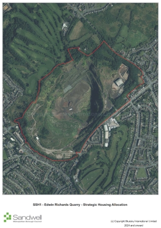 |
||||||||
|
Site constraints
|
||||||||
|
Successful development of the site will require:
|
Reason
Identification of strategic allocations - clarification
MM80
Page / paragraph / policy reference
New policy SSH2 View responses
Proposed change
Include strategic allocation:
Policy SSH2 – Friar Park
16.7The site is located in the north of Sandwell close to the borough boundary with Walsall. It comprises a former sewage farm, together with former farmland that has mostly been restored as open space. The site has had previous land uses; however, it now has the character of a greenfield site.
16.8To the south and west of the site is Friar Park, a large residential estate with associated facilities, and football facility. Bescot Local Distribution Centre (railway sidings) and the Birmingham to Wolverhampton railway line are located to the north and northeast, beyond which is the River Tame and the elevated M6 motorway. To the east is Sandy Lane, beyond which is the A4031 (Walsall Road) and Tame Bridge Parkway railway station.
|
Policy SSH2 – Friar Park |
||||||||
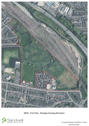 |
||||||||
|
Site constraints
|
||||||||
|
Successful development of the site will require:
|
Reason
Identification of strategic allocations - clarification
MM81 View responses
Page / paragraph / policy reference
New policy SSH3 View responses
Proposed change
Include strategic allocation:
Policy SSH3 – Rattlechain and Land between Addington Way and River Tame
16.9This strategic allocation comprises land north of Temple Way and land between Addington Way and River Tame, which lies approximately 1.8km northwest of Oldbury Town Centre. To the south of the site is the large Temple Way residential estate. To the west is a variety of industrial and employment uses including metal fabricators and cleared land used for open storage and vehicle parking. To the north is the Birmingham Main Line Canal with the Birmingham to Wolverhampton railway line running parallel, beyond which is Sheepwash Nature Reserve. To the east is the River Tame and an area of open space that accommodates areas of woodland. The Gower Branch Canal lies further to the east.
16.10The site has a complex history, including having been used previously for coal mining, as a brick works and clay pit, a tip for fuel ash and commercial waste, and as a deposit for phosphorous waste. Presently the western third of the site comprises a lagoon, which is formed of a main body of water and a smaller ancillary body of water adjacent to the west. The lagoon is approximately 20 metres deep and accommodates the deposits of phosphorous waste, which is monitored through a Waste Management Licence.
16.11The remainder of the allocation accommodates deposits of fuel ash and commercial waste and outwardly comprises a variety of scrubland, grassland and small patches of woodland. The land is undulating, and in the main is higher in elevation than the residential estate to the south, with steep drops particularly down to the River Tame along the eastern boundary.
16.12Despite accommodating previous land uses, the site appears predominantly as greenfield land; due to previous restoration efforts it does not meet the NPPF definition of previously developed land. In addition, at present the site does not meet the definition of ‘contaminated land’ under Part IIA Environmental Protection Act 1990.
|
Policy SSH3 – Rattlechain and Land between Addington Way and River Tame |
||||||||
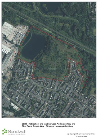 |
||||||||
|
Site constraints
|
||||||||
|
Successful development of the site will require:
|
Reason
Identification of strategic allocations - clarification
MM82 View responses
Page / paragraph / policy reference
New policy SSH4 View responses
Proposed change
Include strategic allocation:
Policy SSH4 – North Smethwick Canalside
16.13The site is one of the key regeneration sites identified within the Smethwick to Birmingham Corridor Framework. It is a brownfield site and is situated to the south of the Birmingham Canal on either side of Rolfe Street. To the south lies the Birmingham to Wolverhampton railway line and the A457 (Tollhouse Way). The area consists of several industrial buildings offering a range of uses including motor repairs, window manufacture, building materials, a hostel, a banqueting suite and vacant buildings. Smethwick Rolfe Street railway station lies to the west of the site and offers regular train services between Wolverhampton and Birmingham New Street. There is an approved Rolfe Street Masterplan in place that will guide future development in the area.
|
Policy SSH4 – North Smethwick Canalside |
||||||||
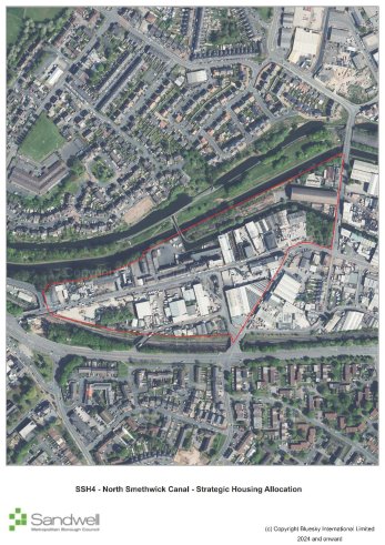 |
||||||||
|
Site constraints
|
||||||||
|
Successful development of the site will require:
|
Reason
Identification of strategic allocations - clarification
MM83
Page / paragraph / policy reference
New paragraphs 16.14 – 16.15
Proposed change
Insert introductory text for Grove Lane Masterplan sites:
Grove Lane Masterplan Sites
16.14. The Grove Lane Masterplan includes six sites that will deliver a substantive amount of housing and will collectively provide strategic benefits. Such benefits include the regeneration of key areas within Smethwick, and contributions to the creation of sustainable communities that support the wider spatial vision for the borough. These are brownfield sites within the Smethwick Regeneration Area, which seek to redevelop existing low quality employment land to residential uses and complement the recent significant investment by Sandwell and West Birmingham NHS Trust in the new Midland Metropolitan University Hospital and associated Learning Campus. The area forms part of the Smethwick to Birmingham Corridor, which follows the route of the Birmingham Main Line Canal.
16.15. The Grove Lane Masterplan proposes the development of a new two-form entry primary school as part of the development of the Grove Lane Area. However, the Infrastructure Development Plan that was produced for the Sandwell Local Plan subsequently did not identify any need for additional mainstream schools within the borough across the plan period. Any requirement for a new school should be revisited and fully assessed as proposals progress.
Reason
Identification of strategic allocations - clarification
MM84
Page / paragraph / policy reference
New policy SSH5
Proposed change
Include strategic allocation:
Policy SSH5 – Abberley Street
16.16. The site lies to the south of Cranford Street, with Winson Street to the east, Abberley Street to the south and the Cape Arm site to the west. The site is divided into two distinct areas with an existing brick-built building on the northern portion. The building has been sub-divided into smaller units with small scale employment uses operating from the majority of them. To the south fronting Abberley Street, the site includes derelict and dilapidated former industrial units with some vacant land.
|
Policy SSH5 – Abberley Street |
||||||||
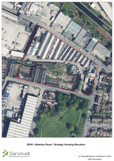 |
||||||||
|
Site constraints
|
||||||||
|
Successful development of the site will require:
|
Reason
Identification of strategic allocations - clarification
MM85
Page / paragraph / policy reference
New policy SSH6
Proposed change
Include strategic allocation:
Policy SSH6 – Cape Arm Cranford Street
16.17The site is bounded by Cranford Street to the north and Cape Arm canal to the south. It comprises a vacant site, covered with a concrete slab that was used as a car park / compound for the construction of the new Midland Metropolitan University Hospital. Derelict buildings front Cranford Street and Abberley Street.
|
Policy SSH6 – Cape Arm Cranford Street |
||||||||
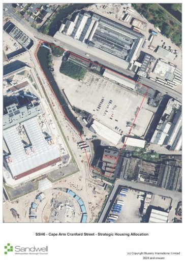 |
||||||||
|
Site constraints
|
||||||||
|
Successful development of the site will require:
|
Reason
Identification of strategic allocations - clarification
MM86 View responses
Page / paragraph / policy reference
New policy SSH7 View responses
Proposed change
Include strategic allocation:
Policy SSH7 – Cranford Street / Heath Street / Canal
16.18The site lies to the north of Cranford Street with the Cape Arm canal to the west and the Birmingham Main Line Canal to the immediate north. The borough boundary with Birmingham lies to the east of the site. Currently most of the site is occupied by older industrial buildings, in use as a factory distribution centre. The remainder of the site accommodates newer, smaller individual industrial units for a range of uses including food distribution, home improvements and motor repairs and testing centre. A cycle route leading from the canal towpath through to Cranford Street has recently been created.
|
Policy SSH7 – Cranford Street / Heath Street / Canal |
||||||||
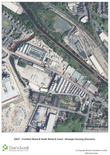 |
||||||||
|
Site constraints
|
||||||||
|
Successful development of the site will require:
|
Reason
Identification of strategic allocations - clarification
MM87
Page / paragraph / policy reference
SSH8
Proposed change
Include strategic allocation:
Policy SSH8 – Grove Lane / Cranford Street / London Street
16.19The site is triangular in shape and bounded by Cranford Street to the north, Grove Lane to the south and London Street to the east. There are multiple land uses within this area including light industrial, motor repairs, van hire, petrol station and vacant buildings. Many of the structures are older industrial premises although there are more recent additions / extensions to some buildings. This site lies adjacent to the new Midland Metropolitan University Hospital.
|
Policy SSH8 – Grove Lane / Cranford Street / London Street |
||||||||
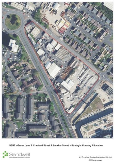 |
||||||||
|
Site constraints
|
||||||||
|
Successful development of the site will require:
|
Reason
Identification of strategic allocations - clarification
MM88
Page / paragraph / policy reference
New policy SSH9
Proposed change
Include strategic allocation:
Policy SSH9 – Grove Street / MMUH
16.20The site is bordered by Grove Street to the west, Dudley Road to the south, Halberton Street and Dugdale Streets to the east and Abberley Street to the north. Comprising mainly older industrial premises in poor condition, the buildings accommodate a range of uses including car repairs, sales, offices, a coach company and a mosque. The new Midland Metropolitan University Hospital lies immediately to the west of this site.
|
Policy SSH9 – Grove Street / MMUH |
||||||||
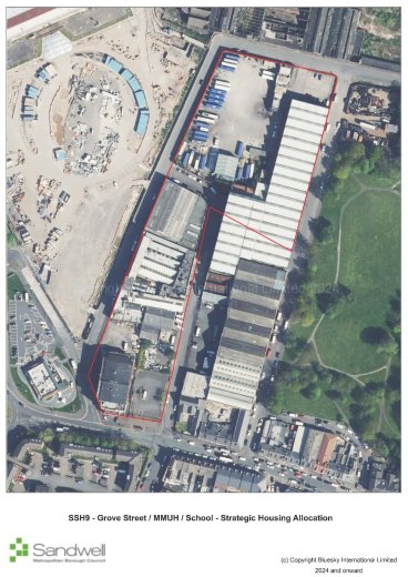 |
||||||||
|
Site constraints
|
||||||||
|
Successful development of the site will require:
|
Reason
Identification of strategic allocations - clarification
MM89
Page / paragraph / policy reference
New policy SSH10
Proposed change
Include strategic allocation:
Policy SSH10 – Molliett Street Park
16.21The site is partially in Sandwell but also includes Moilliett Park, which is located within Birmingham City. The site lies to the north of Dudley Road, which is an established retail centre in Birmingham, with Halberton Street to the west, Winson Street to the east and lying to the south of Abberley Street. The site currently comprises old industrial buildings and Moilliett Park. The part of the site within Sandwell is allocated as SSH10.
|
Policy SSH10 – Moilliett Street Park |
||||||||
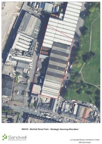 |
||||||||
|
Site constraints
|
||||||||
|
Successful development of the site will require:
|
Reason
Identification of strategic allocations - clarification
MM90
Page / paragraph / policy reference
New paragraph 16.20
Proposed change
Insert introductory text for strategic mixed use allocation sites:
Strategic Mixed Used Allocations
16.22These are mixed used allocations capable of delivering substantive number of dwellings as well as employment development and other development uses and includes sites identified in the West Bromwich Masterplan.
Reason
Identification of strategic allocations - clarification
MM91 View responses
Page / paragraph / policy reference
New policy SSM1 View responses
Proposed change
Include strategic allocation:
Policy SSM1 - Lion Farm
16.23The site is located approximately 1km southwest of Oldbury town centre and 400 metres west of Junction 2 of the M5 motorway. The site comprises 11 adult sized football pitches, which are underused, associated dilapidated changing facilities and car parking in the west, with general open space, a disused social club, areas of woodland and allotments in the north. High voltage power cables cross the site running north to southeast, with two transmission towers located within the site boundary.
16.24To the east of the site is Birchley Industrial Estate, which is occupied by various large office and retail units. Beyond this is Birchley Island, a key road interchange that connects the A4034 and A4123 (Wolverhampton Road) with Junction 2 of the M5. A modern residential estate lies to the northeast of the site. The north of the site is bound by Newbury Lane, beyond which is a residential area. To the west are more residential areas, as well as Lion Farm local centre and St James Church of England Primary School. To the south are residential dwellings and the A4034 (Birchfield Lane), beyond which is Titford Canal and Pool.
16.25 Although the site has been developed previously, it now predominantly comprises playing pitches and has the character of a greenfield site.
|
Policy SSM1 – Lion Farm |
||||||||
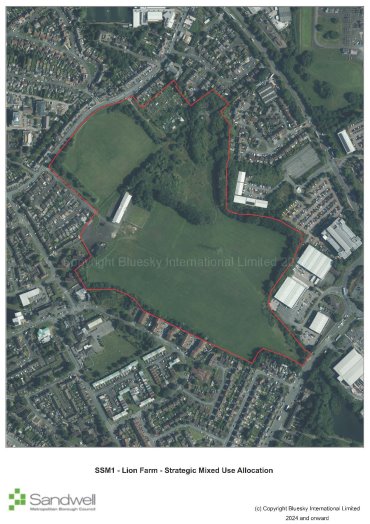 |
||||||||
|
Site constraints
|
||||||||
|
Successful development of the site will require:
|
Reason
Identification of strategic allocations - clarification
MM92
Page / paragraph / policy reference
New paragraph 16.26
Proposed change
Insert introductory text for strategic mixed-use allocations in West Bromwich:
West Bromwich Masterplan Sites
16.26. Four sites in the West Bromwich Masterplan have been identified to deliver mixed uses and together provide strategic benefits.
Reason
Identification of strategic allocations - clarification
MM93 View responses
Page / paragraph / policy reference
New policy SSM2
Proposed change
Include strategic allocation:
Policy SSM2 - Cultural Quarter
16.27The allocation is located within West Bromwich Strategic Centre approximately 150 metres northeast of Lodge Road metro station. The allocation contains several of the town’s main civic buildings. The eastern corner of the site was cleared around eight years ago and there is an apartment block currently under construction on it. The southern half of the site comprises the Edward Street surface level public car park.
16.28To the east of the site is a cluster of banks and the retail core of West Bromwich. To the north are other Victorian buildings, some Grade II listed, which mostly comprise offices and residential conversions. To the west are other attractive Victorian buildings including the Grade II listed Ryland Memorial School of Art, currently in use as a school, and residential buildings. To the south is a Masonic Hall and the Edward Street Hospital, which has recently undergone a partial redevelopment.
|
Policy SSM2 – Cultural Quarter |
||||||||
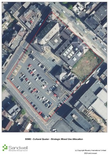 |
||||||||
|
Site constraints
|
||||||||
|
Successful development of the site will require:
|
Reason
Identification of strategic allocations - clarification
MM94
Page / paragraph / policy reference
New policy SSM3
Proposed change
Include strategic allocation:
Policy SSM3 - George Street Living
16.29George Street Living is located on the edge of West Bromwich Strategic Centre on a prominent site adjacent to the A4031 Trinity Way and the Birmingham to Wolverhampton metro line. The allocation currently accommodates a range of light industrial and storage uses as well as ancillary office and retail uses. The former Spring Works site was cleared around ten years ago, resulting in around two thirds of the allocation containing no buildings or fixed structures. The cleared area is currently used for open storage.
16.30To the east of the allocation is the A4031 Trinity Way, a busy dual carriageway that is frequently used by HGVs; beyond is a residential area comprising mostly terraced housing. To the south is the Birmingham to Wolverhampton metro line, beyond which lie further residential properties. A large surface level car park lies to the west. Beyond this is the large Sandwell College building and industrial units on the Lyng Industrial Estate. To the north is George Street and Thomas Street, beyond which are a collection of light industrial uses, community venues and places of worship, and the rear of retail units and other main town centre uses facing the High Street.
|
Policy SSM3 – George Street Living |
||||||||
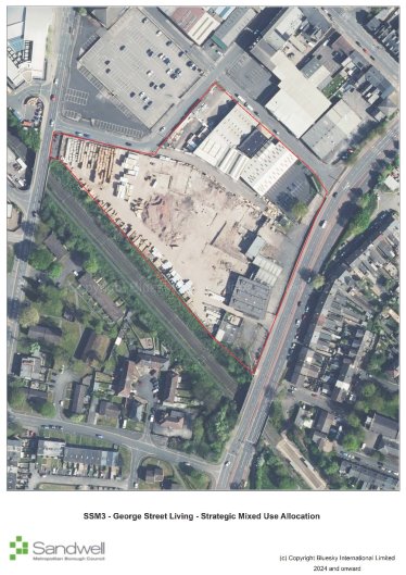 |
||||||||
|
Site constraints
|
||||||||
|
Successful development of the site will require:
|
Reason
Identification of strategic allocations - clarification
MM95
Page / paragraph / policy reference
New policy SSM4
Proposed change
Include strategic allocation:
Policy SSM4 - Queens Square
16.31Queen’s Square Living is located in the heart of West Bromwich Strategic Centre. The site takes in a variety of properties including some of Queens Square Shopping Centre and associated servicing area, a row of retail units fronting High Street, and the cleared sites of the former Bull Street Multi Storey Car Park and the former Marks and Spencer.
16.32The southwest of the allocation is bound by the pedestrianised High Street, beyond which is the West Bromwich Central allocation which currently accommodates a variety of retail and town centre uses. To the northwest is the remainder of Queens Square Shopping Centre and other retail units fronting the High Street. To the north and northeast is the modern New Square retail / leisure development, including the access road to one of the servicing areas for New Square. To the southeast is Bull Street, beyond which are a variety of residential and main town centre uses.
|
Policy SSM4 – Queens Square |
||||||||
 |
||||||||
|
Site constraints
|
||||||||
|
Successful development of the site will require:
|
Reason
Identification of strategic allocations - clarification
MM96
Page / paragraph / policy reference
New policy SSM5
Proposed change
Include strategic allocation:
Policy SSM5 - West Bromwich Central
16.33West Bromwich Central is located at the gateway to West Bromwich Strategic Centre adjacent to the bus and metro stations. The site takes in a variety of town centre premises including Kings Square Shopping Centre and associated servicing yard, several retail units facing the High Street, the former Kings Cinema, the former Indoor Markets, the former Morrisons supermarket (currently occupied by JD Gyms) and a large surface level car park.
16.34To the southwest of the allocation is West Bromwich Ringway, a traffic-calmed boulevard, beyond which is the large Sandwell College building and the Birmingham to Wolverhampton metro line. To the northwest is West Bromwich bus station and the continuation of retail units facing the High Street. To the northeast is the pedestrianised High Street itself, beyond which is the retail heart of the town anchored by Queens Square Shopping Centre and the modern New Square retail / leisure development. To the southeast is Bull Street, beyond which are a variety of uses including offices, retail, small storage and light industrial units, and surface level car parking.
|
Policy SSM5 – West Bromwich Central |
||||||||
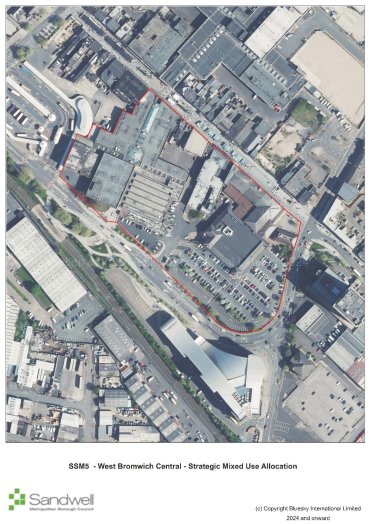 |
||||||||
|
Site constraints
|
||||||||
|
Successful development of the site will require:
|
Reason
Identification of strategic allocations - clarification
MM97
Page / paragraph / policy reference
New paragraphs 16.35 – 16.36
Proposed change
Introduce strategic employment allocation:
Strategic Employment Allocations
16.35. These are defined as vacant employment sites of over seven hectares, identified and assessed in the Black Country Economic Development Needs Assessment or Black Country Employment Area Review as important to the delivery of strategic economic growth.
16.36. Only one site meets these criteria.
Reason
Identification of strategic allocations - clarification
MM98
Page / paragraph / policy reference
New policy SSE1 View responses
Proposed change
Include strategic employment allocation:
Policy SSE1 - Coneygree Business Park (open land)
16.37The site is a vacant site that has remained undeveloped since it formed part of the Coneygree Colliery. It is approximately 1.8km northeast of Dudley town centre, 8.2km southeast of Wolverhampton city centre and 12km northwest of Birmingham city centre.
16.38Access to the site is gained from Coneygree Road, Tipton, which is linked to the A4123 Birmingham New Road.
16.39The site in a predominately mixed used area and was formerly known as Coneygre Mine. The mine has not been in use since the foundry closed in the 1980s. There are no built structures present on the site, although there is an abundance of trees and vegetation and a covering of foundry sand remaining from previous operations.
|
Policy SSE1 - Coneygree Business Park (Open Land) |
||||||||
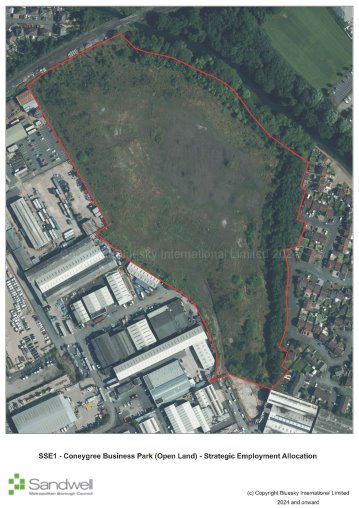 |
||||||||
|
Site constraints
|
||||||||
|
Successful development of the site will require:
|
Reason
Identification of strategic allocations - clarification
MM99
Page / paragraph / policy reference
See MM74
Proposed change
Creation of Chapter 17 for the identification of non-strategic allocations – set out in tables below.
Reason
Clarification
MM100 View responses
Page / paragraph / policy reference
New paragraphs 17.1 – 17.3
Proposed change
Insert new chapter:
Chapter 17 – Non-Strategic Site Allocations
17.1Non-strategic sites are housing, employment, mixed use and gypsy and traveller sites allocations that do not meet the threshold to be considered strategic allocations. They are distributed across the borough and provide a balanced and flexible supply of housing and employment land. These sites make an important contribution to meeting local housing and employment needs and ensuring a diversity of development opportunities throughout the plan period.
17.2This approach ensures that delivery is aligned with infrastructure provision, responds to local needs, and supports the creation of sustainable, inclusive, and well-connected communities consistent with the principles of the NPPF.
17.3The inclusion of a site as a non-strategic allocation does not remove the need for planning permission to be obtained.
Reason
Clarification and amendment following discussion at public examination
MM100 – non-strategic mixed-use allocations View responses
| Site ref | Site name and address | Ward | Town | Indicative capacity | Gross site area (ha) Land type |
Indicative net developable area (ha) | Net density (dph) | Anticipated delivery timescale (completion year) | Further information |
|---|---|---|---|---|---|---|---|---|---|
| SH1 | Brown Lion Street | Tipton Green | Tipton | 28 | 0.46 Brownfield |
0.46 | 59 | 2026-2027 | Granted consent for 27 dwellings - DC/23/67972 |
| SH2 | Land adjacent to Asda, Wolverhampton Road, Oldbury | Langley | Oldbury | 60 | 1.6 Greenfield |
1.6 | 41 | 2028-2029 | Access issue will need to be overcome. Siting of houses should safeguard existing residential amenity and the asset of the watercourse. |
| SH4 | Lower High Street (Station Hotel and Dunns site). | Cradley Heath and Old Hill | Rowley Regis | 20 | 0.28 Brownfield |
0.28 | 71 | 2032-2033 | N/A |
| SH5 | Mill Street, Great Bridge | Great Bridge | Tipton | 40 | 0.86 Brownfield |
0.86 | 45 | 2028-2029 | Applications on part of site. DC/22/67019 - Land at Mill Street Tipton Proposed 20 no. dwellings with associated parking. DC/22/67018 - 8 homes pending consent. Within Wednesbury Regeneration Area |
| SH6 | Swan Lane, north of A41 West Bromwich | Greets Green and Lyng | West Bromwich | 147 | 3.78 Brownfield |
2.42 | 61 | 2026-2029 | Application - DC/22/66532: Proposed 147 dwelling houses (65 houses and 82 apartments) |
| SH7 | The Boat Gauging House and adjoining land, Factory Road, Tipton | Tipton Green | Tipton | 50 | 0.57 Brownfield |
0.57 | 88 | 2028-2030 | Application - DC/21/65872 – Proposed residential development comprising of 46 no. 1 and 2 bed apartments, and conversion of boat house to 4 no. 2 bed residential units. Within Tipton and Dudley Port Regeneration Area. Development proposals should have regard to the heritage assets on site in scale, form and impact on character. |
| SH8 | Alma Street, Wednesbury | Friar Park | Wednesbury | 23 | 0.52 Brownfield |
0.52 | 44 | 2030-2031 | N/A |
| SH9 | The Phoenix Collegiate, Friar Park Road, Wednesbury | West Bromwich Central | West Bromwich | 105 | 4.80 Brownfield |
2.35 | 30 | 2026-2028 | Application - DC/20/63911: Proposed residential development of up to 84 No. dwellings, associated public open space and infrastructure (outline application for access). Playing field loss mitigation may be required as per SHW5 |
| SH10 | Tipton Conservative and Unionist Club, 64 Union Street, Tipton | Tipton Green | Tipton | 15 | 0.19 Brownfield |
0.19 | 74 | 2029-2030 | Application - DC/19/62733: Proposed change of use to residential, to include 7 No. 1 bed properties and 7 No. 2 bed properties. Application has now expired. Within Tipton and Dudley Port Regeneration Area |
| SH11 | Sandwell District and General Hospital, West Bromwich | West Bromwich Central | West Bromwich | 121 | 0.82 Brownfield |
0.82 | 148 | 2030-2032 | Application - DC/20/64894: Demolition of existing building and proposed mixed use development comprising of 12 No. houses and 109 No. apartments for key workers. Application has now expired. |
| SH13 | Silverthorne Lane / Forge Lane, Cradley Heath | Cradley Heath and Old Hill | Rowley Regis | 81 | 2.41 Brownfield |
1.81 | 45 | 2035-2038 | N/A |
| SH14 | Langley Maltings, Western Road, Langley | Oldbury | Oldbury | 71 | 2.72 Brownfield |
2.04 | 35 | 2040-2041 | Density reflects that this the site contains a Grade II listed building. Development proposals should have full regard to adjacent heritage assets in scheme layout, design and appearance |
| SH15 | Macarthur Road Industrial Estate, Cradley Heath | Cradley Heath and Old Hill | Rowley Regis | 13 | 0.3 Brownfield |
0.3 | 43 | 2035-2036 | N/A |
| SH16 | Cradley Heath Factory Centre, Woods Lane, Cradley | Cradley Heath and Old Hill | Rowley Regis | 170 | 4.85 Brownfield |
3.64 | 45 | 2030-2035 | Part of site has application - DC/21/66444: Proposed demolition of existing industrial buildings and development of 34 No. dwellings. Part of the site with planning permission is developed. |
| SH17 | Land adjacent Droicon Estate, Portway Road, Rowley Regis | Rowley | Rowley Regis | 28 | 0.7 Brownfield |
0.7 | 40 | 2030-2031 | N/A |
| SH19 | Land at Horseley Heath, Alexandra Road and Lower Church Lane, Tipton | Great Bridge | Tipton | 77 | 2.26 Brownfield |
1.7 | 40 | 2040-2041 | SLINC SA028 – Alexandra Road to the north of the site. SLINC SA103:1 Dixons Branch Canal to the south of the site. Development proposals where adjacent to the canal should have full regard to the nature conservation needs of the SLINC |
| SH20 | Elbow Street, Old Hill | Cradley Heath and Old Hill | Rowley Regis | 33 | 0.77 Brownfield |
0.77 | 43 | 2032-2033 | N/A |
| SH21 | Dudley Road East | Oldbury | Oldbury | 90 | 2.65 Brownfield |
2.00 | 45 | 2035-2038 | Adjacent to a SINC SA038 – Gower Branch Canal. Within Tipton and Dudley Port Regeneration Area. Development proposals where adjacent to the canal should have full regard to the nature conservation needs of the adjacent SINC. |
| SH22 | Tatbank Road, Oldbury | St Pauls | Smethwick | 52 | 1.15 Brownfield |
1.15 | 45 | 2040-2041 | N/A |
| SH23 | 28-64 High Street, West Bromwich | West Bromwich Central | West Bromwich | 53 | 0.60 Brownfield |
0.60 | 88 | 2031-2033 | N/A |
| SH24 | Cokeland Place/ Graingers Lane, Cradley Heath | Cradley Heath and Old Hill | Rowley Regis | 16 | 0.36 Brownfield |
0.36 | 44 | 2035-2036 | N/A |
| SH25 | Bradleys Lane/ High Street, Tipton | Prince's End | Tipton | 189 | 5.60 Brownfield |
4.20 | 45 | 2038-2041 | An appropriate remediation strategy to be agreed and implemented with relevant stakeholders to address contamination issues (Policy SCO3). Adjacent to Brierley Lane Open Space, which is also a SLINC SA011- Dudley to Priestfield Disused Railway. Appropriate mitigation will be required. |
| SH26 | Lower City Road, Oldbury | Oldbury | Oldbury | 73 | 1.83 Brownfield |
1.83 | 40 | 2035-2038 | An appropriate remediation strategy to be agreed and implemented with relevant stakeholders to address contamination issues (Policy SCO3). Development proposals should have full regard for the canal side location. Within Tipton and Dudley Port Regeneration Area. |
| SH27 | Site surrounding former Post office and Telephone Exchange, Horseley Heath | Great Bridge | Tipton | 52 | 1.16 Brownfield |
1.16 | 45 | 2034-2036 | N/A |
| SH28 | Friar Street, Wednesbury | Friar Park | Wednesbury | 45 | 1.01 Brownfield |
1.01 | 45 | 2040-2041 | Adjacent to SLINC SA002 Woden Road South. Development proposals should have full regard to the nature conservation needs of the adjacent SINC. |
| SH29 | Used car sales site, corner of Lower Church Lane and Horseley Heath, Tipton | Tipton Green | Tipton | 23 | 0.56 Brownfield |
0.56 | 41 | 2040-2041 | N/A |
| SH30 | Land to east of Black Lake, West Bromwich | Hateley Heath | West Bromwich | 83 | 2.45 Brownfield |
1.83 | 45 | 2040-2041 | Site adjacent to SINC SA034 Ridgeacre Branch Canal. Development proposals where adjacent to the canal should have full regard to the nature conservation needs of the adjacent SINC. |
| SH31 | Summerton Road, Oldbury | Oldbury | Oldbury | 36 | 0.89 Brownfield |
0.89 | 40 | 2035-2037 | Development proposals should have full regard for the canal side location. |
| SH32 | Bank Street (West), Hateley Heath | Hateley Heath | West Bromwich | 43 | 0.85 Brownfield |
0.85 | 51 | 2030-2032 | N/A |
| SH33 | Wellington Road, Tipton | Tipton Green | Tipton | 40 | 0.91 Brownfield |
0.91 | 44 | 2040-2041 | Within Tipton and Dudley Port Regeneration Area |
| SH34 | Brandhall Golf Course | Old Warley | Oldbury | 190 | 5.18 Greenfield |
3.88 | 48 | 2026-2031 | Application - DC/23/68540: Proposed demolition of existing buildings and erection of 1 No. primary school, 190 No. dwellings, public open space, landscaping and associated works (outline application with all matters reserved). Golf course loss mitigation as per SHW5 |
| SH38 | Brades Road, Oldbury | Oldbury | Oldbury | 51 | 1.16 Brownfield |
1.16 | 45 | 2030-2031 | Gas pipeline possibly running along line of canal could constrain the site and reduce development capacity. Appropriate mitigation should be considered. |
| SH40 | Langley Swimming Centre, Vicarage Road, Oldbury | Langley | Oldbury | 20 | 0.49 Brownfield |
0.49 | 41 | 2026-2027 | N/A |
| SH42 | Forge Tavern, Franchise Street, Wednesbury | Wednesbury North | Wednesbury | 10 | 0.14 Brownfield |
0.14 | 71 | 2031-2032 | N/A |
| SH43 | Land off Tanhouse Avenue, Great Barr | Newton | West Bromwich | 46 | 1.66 Greenfield |
1.15 | 40 | 2040-2041 | SLINC SA045:20 Tanhouse Avenue will need to be mitigated. Adjacent to SINC SA045 Forge Mill. Any proposal will need to allow for access to the adjacent playing field. Playing field loss mitigation may be required as per SHW5 |
| SH44 | Wyndmill Crescent, West Bromwich | Charlemont | West Bromwich | 11 | 0.19 Brownfield |
0.19 | 58 | 2033-2034 | N/A |
| SH45 | Site of 30-144 Mounts Road, Wednesbury | Wednesbury South | Wednesbury | 45 | 1.07 Brownfield |
1.07 | 42 | 2025-2026 | DC/22/67797 - Proposed residential development comprising of 45 dwellings, landscaping and car parking. Site under construction |
| SH47 | Site of former Stone Cross Neighbourhood Office | Charlemont with Grove Vale | West Bromwich | 14 | 0.32 Brownfield |
0.32 | 47 | 2029-2030 | Application DC/18/61923 – Proposed erection of dwellings. New planning application submitted DC/23/6896 |
| SH49 | Johns Street, Carters Green | West Bromwich Central | West Bromwich | 33 | 0.82 Brownfield |
0.82 | 40 | 2032-2033 | Within Carters Green Regeneration Area |
| SH50 | Tentec, Guns Lane | West Bromwich Central | West Bromwich | 129 | 0.6 Brownfield |
0.6 | 210 | 2030-2033 | Application DC/22/67454 – Proposed new build development of 129 apartments with amenities, 69 onsite parking spaces and associated landscaping – pending decision. Within Carters Green Regeneration Area |
| SH51 | Providence Place / Bratt Street, West Bromwich | West Bromwich Central | West Bromwich | 40 | 0.74 Brownfield |
0.74 | 100 | 2037-2038 | Part of West Bromwich Masterplan. Within West Bromwich Regeneration Area. Applicants will need to assess impact on heritage including the Grade II Listed Highfields buildings and demonstrate acceptability of the proposal. |
| SH52 | Overend Street, West Bromwich | West Bromwich Central | West Bromwich | 70 | 0.71 Brownfield |
0.71 | 99 | 2039-2041 | Remaining element of Eastern Gateway. Within West Bromwich Regeneration Area. |
| SH59 | Beever Road | Great Bridge | Tipton | 18 | 0.83 Brownfield |
0.83 | 22 | 2025-2026 | Application - DC/21/65582: Proposed 10 No. bungalows and 8 No. flats. Site under construction in 2024 |
| SH61 | Thandi Coach Station, Alma Street, West Bromwich | Soho and Victoria | Smethwick | 58 | 0.71 Brownfield |
0.71 | 82 | 2029-2030 | Application - DC/17/60747: Proposed residential development of 54 No apartments and 4 No. houses – made a start on site. Within Smethwick Regeneration Area |
| SH62 | Star and Garter, 252 Duchess Parade, West Bromwich | West Bromwich Central | West Bromwich | 60 | 0.05 Brownfield |
0.05 | 200 | 2031-2032 | Application - DC/21/65798: Proposed nine storey mixed use development comprising of 1 No. retail unit at ground floor and 60 No. apartments above. Within West Bromwich Regeneration Area. |
| SH63 | 192 – 200 Dudley Road, Oldbury, B69 3DS | Oldbury | Oldbury | 24 | 0.58 Brownfield |
0.58 | 41 | 2031-2032 | N/A |
| SH64 | Windmill House, Windmill Lane, Smethwick | Soho and Victoria | Smethwick | 10 | 0.21 Brownfield |
0.21 | 47 | 2030-2031 | N/A |
| SH65 | Smethwick Police Station, Piddock Road, Smethwick B66 3BL | Soho and Victoria | Smethwick | 10 | 0.22 Brownfield |
0.22 | 45 | 2030-2031 | The site is entirely within the Smethwick High Street and Crocketts Lane Conservation Area and is home to Locally Listed buildings that stand within the setting of heritage assets including a statutory Listed Building. Proposals will be required to demonstrate acceptability in terms of material planning considerations including impacts on heritage. |
| SH66 | Wednesbury Police Station, Albert Street, Wednesbury | Wednesbury South | Wednesbury | 15 | 0.33 Brownfield |
0.33 | 45 | 2030-2031 | Proposals will need to take account of impact upon the setting of the nearby listed Richards Art Gallery and adjacent locally listed buildings. Heritage is a component of the Council's strategic vision for Wednesbury as set out the in Wednesbury Town Centre Masterplan. |
| SH67 | Land at Tippity Green (golf course) Rowley Regis | Rowley | Rowley Regis | 250 | 10.30 Greenfield and brownfield |
6.25 | 40 | 2028-2031 | Part of the site is within Alsopp's Hill which is designated as a SLINC. Appropriate mitigation will be required. Part of the site is a historic landfill site. As such, appropriate remediation is required to address the potential environmental risk to groundwater, surface waters and human health. Golf course loss mitigation as per SHW5 |
| Site Ref | Site Name and Address | Ward | Town | Appropriate Uses and Capacities | Gross Site Area (Ha) Land Type (Brownfield or Greenfield) |
Anticipated Delivery Timescale (Completion Year) | Further Information |
|---|---|---|---|---|---|---|---|
| SM1 | Chances Glass Works, land west of Spon Lane, north of Palace Drive | St Pauls | West Bromwich | Housing – 276 units Workspace – 7,208m² Heritage centre – 779m² Open space – 1ha New highways access onto Spon Lane |
0.64 Brownfield |
2040–2041 |
Heritage-led regeneration appropriate programme given the identified heritage assets within the sites (Grade II Listed Building, Scheduled Ancient Monument, Galton Valley Conservation Area). The site is a key industrial heritage site. Consequently, proposals for regeneration should have particular regard to the heritage assets in all respects. |
| SM3 | Evans Halshaw car showroom, Carters Green | West Bromwich Central | West Bromwich | 140 units Ancillary commercial – 7 units (approx. 2,000m² total) |
0.89 Brownfield |
2030–2033 | Within West Bromwich Regeneration Area. Given its prominent location, there is potential for impact on the street scene. This, together with impacts on nearby heritage assets, will be material in determination of any application. |
| SM4 | Army Reserve, Carters Green | West Bromwich Central | West Bromwich | Housing 63 units Ancillary commercial 4 units (approx. 1,000m² total) |
1.17 Brownfield |
2035–2037 | Within West Bromwich Regeneration Area. Given its prominent location, there is potential for impact on the street scene. This, together with impacts on nearby heritage assets, will be material in determination of any application. |
| Site Ref | Site Name and Address | Ward | Town | Gross Site Area (Ha) | Further Information |
|---|---|---|---|---|---|
| SEC1-1 | Whitehall Road, Tipton | Great Bridge | Tipton | 5.3 | N/A |
| SEC1-2 | British Gas, Land off Dudley Road, Oldbury | Oldbury | Oldbury | 1.05 | N/A |
| SEC1-3 | Junction Two, Oldbury | Oldbury | Oldbury | 1.12 | N/A |
| SEC1-5 | Site off Bilport Lane, Wednesbury | Wednesbury South | Wednesbury | 5.29 |
The development will be developed with the following site-specific criteria: VT ROUTE TWR (001A – 016): 400kV – A strategy for responding to the NGET overhead transmission lines present within the site that demonstrates how the NGET Design Guide and Principles have been applied at the masterplanning stage and how the impact of the assets has been reduced through good design. |
| SEC1-6 | Brandon Way / Albion Road | Greets Green and Lyng | West Bromwich | 1.54 | N/A |
| SEC1-7 | Legacy 43, Ryder Street, West Bromwich | Great Bridge | West Bromwich | 0.88 | N/A |
| SEC1-8 | Roway Lane, Oldbury | Oldbury | Oldbury | 3.65 |
The development will be developed with the following site-specific criteria: VT ROUTE TWR (019 – 036): 400kV Overhead Transmission Line route: KITWELL – OCKER HILL – A strategy for responding to the NGET overhead transmission lines present within the site that demonstrates how the NGET Design Guide and Principles have been applied at the master planning stage and how the impact of the assets has been reduced through good design. |
| Site Ref | Site Name and Address | Ward | Town | Gross Site Area (Ha) | Indicative Net Developable Area (Ha) | Indicative Capacity | Anticipated Delivery Timescale (Completion Year) | Further Information |
|---|---|---|---|---|---|---|---|---|
| SG1 | Brierley Lane | Princess End | Tipton | 0.73 | 0.73 | 10 pitches | 2030–2031 | Extension to caravan site – funding required |
| SG2 | Brierley Lane | Princess End | Tipton | 0.75 | 0.73 | 16 pitches | N/A | Allocation to safeguard existing use as gypsy and traveller site |
MM101 View responses
Page / paragraph / policy reference
Chapter 16
Proposed change
Renumber chapter to account for insertion of new chapters before it. Make consequential changes accordingly:
16 18. Delivery, Monitoring, and Implementation
Reason
Update
Page / paragraph / policy reference
Paragraph 16.2 View responses
Proposed change
Amend and reorder text:
16.2 Monitoring indicators for each chapter of the Plan are set out below. Performance against the indicators will provide the Council and interested stakeholders with important data about development and land-use change within Sandwell. It will show whether the policies are performing effectively and if the Council should commence an early review of the Plan.
16.3 Performance against the indicators will also provide the Council and interested stakeholders with important data about development and land-use change within Sandwell.
16.3 Notwithstanding this, the Council is required under the transitionary arrangements set out in paragraph 236 of the 2024 version of the NPPF to begin work on a new local plan under the revised plan-making system provided for under the Levelling Up and Regeneration Act 2023, as soon as the relevant provisions are brought into force. The preparation of the new plan will run concurrently with the preparation of a Spatial Development Strategy, which is expected to include the authorities that are constituent members of the West Midlands Combined Authority, including Sandwell.
Reason
MM102
Page / paragraph / policy reference
Figures 6, 8, 12 and 13
Proposed change
In the key for Bearwood, Cape Hill, Wednesbury and West Bromwich Town Centre Maps
Delete Retail Core and replace with Primary Shopping Area
Reason
Update and consistency
MM103
Page / paragraph / policy reference
Figure 14
Proposed change
Figure 14 Existing Transport Network
Add canal network to map
Reason
Canal network added