Addendum to the Regulation 19 Sustainability Appraisal
3 Main Modification One – Proposed additional site allocation
3.1 Overview
3.1.1 The proposed main modification seeks to allocate 10.3 hectares of land at Rowley Regis Golf Course for housing development. The site is capable of accommodating approximately 250 new homes. The location of the site is shown in Figure 3.1.
3.1.2 As explained in Chapter 2, the methodology used to evaluate the additional site is consistent with that used to evaluate all reasonable alternative sites in the SA process to date. Appendix D of the Regulation 19 SA Report[18] outlines the assessment receptors, data sources and assumptions applied in the evaluation of reasonable alternative sites.
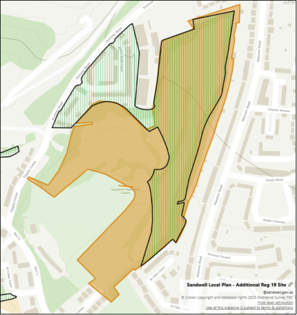
Figure 3.1: Site location plan showing the proposed residential allocation in orange and the retained Alsopp's Hill SLINC in striped green (extracted from SLP Main Modifications Document)
3.2 SA Objective 1: Cultural Heritage
Grade I Listed Building
3.2.1 There are two Grade I Listed Buildings in Sandwell, 'West Bromwich Manor House' and 'Galton Bridge', and several others nearby in surrounding authority areas. The proposed development at the site is not anticipated to impact Grade I Listed Buildings given the distance from the site to the nearest listed building. A negligible impact is identified.
Grade II* Listed Building
3.2.2 There are eight Grade II* Listed Buildings within Sandwell, mostly concentrated in and around the Smethwick area in the south east of the borough. The proposed development at the site is not anticipated to impact Grade II* Listed Buildings given the distance from the site to the nearest listed building. A negligible impact is identified.
Grade II Listed Building
3.2.3 Throughout Sandwell, a significant number of Grade II Listed Buildings can be found, often concentrated in developed areas, adjacent to the canal network, and most notably within the historic centres of West Bromwich and Oldbury. The site is located approximately 180 metres from the Grade II Listed 'Saint Giles Church, Rowley Regis'. However, the presence of intervening built development and mature vegetation effectively screens the site from the heritage asset. As a result, the proposal is considered to have a negligible impact on the setting and significance of the listed building.
Conservation Area
3.2.4 Sandwell contains nine Conservation Areas, the majority of which cover sections of the urban area, as well as portions of the canal network, historic open spaces and nature reserves. Proposed development at the site is unlikely to have a significant impact on the setting of a Conservation Area, as such a negligible impact is identified.
Scheduled Monument
3.2.5 There are eight Scheduled Monuments (SMs) within Sandwell, generally covering previously developed areas in relation to Birmingham Canal or areas with industrial history. The proposed development at the site is unlikely to significantly impact the setting of an SM; a negligible impact is identified.
Registered Park and Garden
3.2.6 Five Registered Parks and Gardens (RPGs) can be found within Sandwell: 'Brunswick Park', 'Victoria Park (Tipton)', 'Dartmouth Park', 'Warley Park' and a small proportion of 'Great Barr Hall'. The site is deemed unlikely to have a significant impact on the setting of any RPG given the distance from the site to the nearest RPG; as such, a negligible impact is identified.
Archaeological Priority Area
3.2.7 Archaeological Priority Areas (APAs) have been identified throughout Sandwell's urban and undeveloped areas. The site is not located in close proximity to APAs, and therefore, the proposed development at the site will be likely to have a negligible impact on the setting of APAs.
Historic Landscape Characterisation
3.2.8 The Black Country Historic Landscape Characterisation (HLC) Study[19] has identified a range of Historic Environment Area Designations within the Black Country, covering a large proportion of Sandwell's parkland and Green Belt as well as a number of features within the urban areas. The site does not coincide with any identified areas of high historic value, and therefore, the proposed development will be expected to have a negligible impact on the local historic environment.
Table 3.1: Site impact matrix for SA Objective 1 – Cultural heritage
|
Site Name |
Grade I Listed Building |
Grade II* Listed Building |
Grade II Listed Building |
Conservation Area |
SM |
RPG |
APA |
HLC |
|
Rowley Regis Golf Course |
0 |
0 |
0 |
0 |
0 |
0 |
0 |
0 |
3.3 SA Objective 2: Landscape
Landscape Sensitivity
3.3.1 The Black Country Landscape Sensitivity Assessment[20] identified the extent to which the character and quality of Black Country Green Belt land is susceptible to change as a result of future development. In Sandwell, Green Belt is restricted to the north east of the borough, at Sandwell Valley. The site is located outside of the Green Belt, and as such outside of the Landscape Sensitivity Assessment study area. Therefore, the potential effects of the site on sensitive landscapes are uncertain.
Table 3.2: Site impact matrix for SA Objective 2 – Landscape
|
Site Name |
Landscape Sensitivity |
|
Rowley Regis Golf Course |
+/- |
3.4 SA Objective 3: Biodiversity
European sites
3.4.1 European sites are a network of nature protection areas which include Special Areas of Conservation (SACs) and Special Protection Areas (SPAs). There are no European sites within Sandwell, with the nearest being 'Fens Pools' SAC located approximately 3km to the west, in Dudley. No Zone of Influence has been identified for 'Fens Pools' SAC to indicate areas where development could potentially result in significant adverse effects on its designated features, and therefore, at the time of writing the impact of the site on European sites is uncertain.
Sites of Special Scientific Interest
3.4.2 There are no Sites of Special Scientific Interest (SSSIs) within Sandwell Borough, however nearby SSSIs include 'The Leasowes' and 'Doulton's Claypit' in the neighbouring borough of Dudley. The site is located within an Impact Risk Zone (IRZ) which does not indicate the proposed use as a threat to nearby SSSIs, and as such, the proposed development at the site will be likely to have a negligible impact on SSSIs.
National Nature Reserves
3.4.3 There are no National Nature Reserves (NNRs) within Sandwell, with 'Wren's Nest' and 'Saltwells' NNRs in Dudley being the closest to the borough, located at their closest points approximately 800m and 700m to the west of Sandwell, respectively. The site is not located in close proximity to a NNR and therefore the proposed development will be unlikely to have a significant impact on NNRs.
Ancient Woodland
3.4.4 In Sandwell, there are some small areas of ancient woodland including 'Codsall Coppice' and 'Warley Rack Wood' in the south of the borough, and 'Dartmouth Golf Wood' and 'Chambers Wood' towards the north east. The site is not located in close proximity to these areas of ancient woodland and therefore the proposed development at the site will be unlikely to have a significant impact on any ancient woodland.
Local Nature Reserves
3.4.5 There are nine Local Nature Reserves (LNR) within Sandwell, found within both the urban areas and Green Belt, including 'Sheepwash', 'Merrion Wood' and 'Sot's Hole with Bluebell Wood' LNRs. The site is not located in close proximity to a LNR and therefore the proposed development will be unlikely to have a significant impact on LNRs.
Sites of Importance for Nature Conservation
3.4.6 Within Sandwell, there are 33 Sites of Importance for Nature Conservation (SINCs). The site is not located in close proximity to a SINC and therefore the proposed development will be unlikely to have a significant impact on SINCs.
Sites of Local Importance for Nature Conservation
3.4.7 There are 71 Sites of Local Importance for Nature Conservation (SLINCs) found throughout Sandwell, but particularly in the south west and north east of the borough. A large proportion (46.5%) of the site coincides with 'Alsopp's Hill' SLINC. The proposed development of 250 dwellings at the site could potentially have a minor negative impact on the SLINC through loss or degradation of this local biodiversity asset.
Geological Sites
3.4.8 Geological sites have been identified throughout the Plan area, which form part of the Black Country Global Geopark[21]. These sites include a range of notable geological features and formations, including a number of SSSIs and SINCs. Within Sandwell, there are five geological sites found in the east and south west of the borough, including 'The Rowley Hills', 'Blue Rock Quarry SINC' and 'Bumble Hole & Warren's Park LNR'. The proposed development the site will be likely to have a negligible impact on geological sites as the site does not coincide with any identified areas of geological importance.
Priority Habitat
3.4.9 Some small extents of priority habitats are found throughout the Sandwell area, particularly concentrated in the Green Belt to the north east and include 'coastal and floodplain grazing marsh', 'good quality semi-improved grassland' and 'deciduous woodland'. The site does not coincide with any identified priority habitat; therefore, the proposed development is likely to have a negligible impact on the overall presence of priority habitats across the borough.
Table 3.3: Site impact matrix for SA Objective 3 – Biodiversity
|
Site Name |
European Sites |
SSSIs and IRZs |
NNRs |
Ancient Woodland |
LNRs |
SINCs |
SLINCs |
Geological Sites |
Priority Habitats |
|
Rowley Regis Golf Course |
+/- |
0 |
0 |
0 |
0 |
0 |
- |
0 |
0 |
3.5 SA Objective 4: Climate change mitigation
Potential Increase in Carbon Footprint
3.5.1 The estimated carbon dioxide (CO2) emissions for Sandwell in 2022 (the latest available data when the Regulation 19 SA was prepared) was 1,247.3 kilotonnes, with per capita emissions of 3.6 tonnes, according to UK local authority CO2 emissions data[22]. Sandwell has an average of 2.7 people per dwelling[23].
3.5.2 Based on these figures, and assuming new residents will generate CO2 emissions in line with the current average, it has been calculated that proposals for 1,283 homes or more are expected to increase carbon emissions by 1% or more in comparison to the current estimates for Sandwell. Proposals for 128 homes or more are expected to increase carbon emissions by 0.1% or more in comparison to current estimates for Sandwell.
3.5.3 Residential-led development is likely to result in an increase in carbon emissions, to some extent. The site proposes the development of 250 dwellings and therefore a minor negative impact on Sandwell's carbon emissions will be expected.
Table 3.4: Site impact matrix for SA Objective 4 – Climate change mitigation
|
Site Name |
Potential increase in carbon footprint |
|
Rowley Regis Golf Course |
- |
3.6 SA Objective 5: Climate Change Adaptation
Flood Zones
3.6.1 Flood Zones 2 and 3 occur alongside watercourses throughout the borough, such as the River Tame, with the majority of areas at risk of fluvial flooding found towards the north. The site is located wholly within Flood Zone 1 and therefore will be expected to have a minor positive impact on flooding, as the proposed development at the site will be likely to locate site end users away from areas at risk of fluvial flooding.
Indicative Flood Zone 3b
3.6.2 Indicative Flood Zone 3b is present in areas where flooding will potentially worsen in the future due to climate change, areas of which are scattered throughout Sandwell generally covering areas currently within Flood Zone 3a according to the Black Country Level 1 Strategic Flood Risk Assessment (SFRA)[24] which was the most up-to-date SFRA at the time of preparing the Regulation 19 SA (now superseded by Sandwell Level 1 SFRA[25]). The site is not located within Flood Zone 3b, and therefore it is likely the proposed development will result in a negligible impact on contributing to flooding issues in the future, although further site-specific assessments would help to provide a more accurate picture of changing flood risk due to climate change.
Surface water flood risk
3.6.3 Surface Water Flood Risk (SWFR) is categorised into low (1/1000), medium (1/100) and high (1/30) in relation to the probability of surface water flooding occurring in a given area. Areas affected by surface water flooding can be found throughout Sandwell, in particular along roads, as well as within urban parkland, and associated with ponds and watercourses. Small proportions of low surface water flood risk are scattered throughout the site, and insignificant areas of medium and high risk. The proposed development at the site is anticipated to result in a minor negative impact on surface water flooding.
Table 3.5: Site impact matrix for SA Objective 5 – Climate change adaptation
|
Site Name |
Fluvial Flood Zones |
Indicative Flood Zone 3b |
Surface Water Flood Risk |
|
Rowley Regis Golf Course |
+ |
0 |
- |
3.7 SA Objective 6: Natural Resources
Previously Undeveloped Land / Land with Environmental Value
3.7.1 Sandwell is largely built-up, although it also contains a range of large green spaces distributed throughout the borough and a small proportion of undeveloped Green Belt land in the north east. The site comprises 10.3ha of land, which was historically quarried and used for landfill, following which it was landscaped and currently comprises a golf course. In line with the National Planning Policy Framework (NPPF) definition the site is therefore classed as undeveloped land[26]. The site area contains features that are likely to be of environmental value such as hedgerows, trees and scrub associated with the current golf course land use that would potentially be lost upon development. The proposed development at the site is identified to have a minor negative impact on natural resources due to the potential loss of ecologically or environmentally valuable soil resources.
BMV Land
3.7.2 The land within Sandwell Borough is almost entirely 'Urban' according to the Agricultural Land Classification (ALC), with a small proportion of 'Non-Agricultural' and Grade 4 land in the north east. The site wholly comprises previously undeveloped land and will be likely to have a minor positive impact on natural resources due to the site being located upon areas of less agriculturally important 'Urban' land, helping to prevent loss of 'best and most versatile' (BMV) land across the borough.
Table 3.6: Site impact matrix for SA Objective 6 – Natural resources
|
Site Name |
Previously Undeveloped Land / Land with Environmental Value |
BMV Land |
|
Rowley Regis Golf Course |
- |
+ |
3.8 SA Objective 7: Pollution
Air Quality Management Area
3.8.1 The entirety of Sandwell Borough is classed as 'Sandwell Air Quality Management Area' (AQMA). The site is wholly located within this AQMA. The proposed development at the site will be likely to locate site end users in areas of existing poor air quality, as such a minor negative impact on air pollution is identified.
Main road
3.8.2 Many major roads pass through Sandwell, including the A34, A4041, M5, and the M6 Motorway. The site is located over 200m from a main road. The proposed development at the site will be expected to have a negligible impact on exposure of site end users to transport associated air and noise pollution associated with main roads.
Watercourse
3.8.3 There are several watercourses within Sandwell, including the River Tame and various canals and brooks. The site is located over 10m from a watercourse and is less likely to result in significant impacts on the quality of watercourses. However, the site would need to be evaluated according to land use type, size of development and exact location. The proposed development at the site has the potential to lead to adverse impacts such as those resulting from runoff. The potential effect of the site on water quality is uncertain.
Groundwater Source Protection Zone
3.8.4 Source Protection Zones (SPZs) for groundwater within Sandwell are located only within the south east of the borough. SPZs are grouped from 1 to 3 based on the level of protection that the groundwater requires. The site does not coincide with the catchment of any SPZ; therefore, the proposed development at the site will be expected to have a negligible impact on quality or status of groundwater.
Potential Increase in Air Pollution
3.8.5 The construction and occupation of 250 dwellings proposed at the site could potentially result in significant increase in local air pollution. A major negative impact is identified. This includes potential impacts associated with traffic generated as a result of the proposed development; further site-specific assessment would help to better quantify this effect.
Table 3.7: Site impact matrix for SA Objective 7 – Pollution
|
Site Name |
AQMA |
Main Road |
Watercourse |
Groundwater SPZ |
Potential Increase in Air Pollution |
|
Rowley Regis Golf Course |
- |
0 |
+/- |
0 |
-- |
3.9 SA Objective 8: Waste
Potential Increase in Household Waste Generation
3.9.1 Residential-led development is likely to result in an increase in household waste generation, to some extent. According to the UK local authority household waste data[27], approximately 132,228 tonnes of waste was produced within Sandwell in 2022/2023 (the latest available data when the Regulation 19 SA was prepared). It is assumed that new residents in Sandwell will have an annual waste production of 377kg per person, in line with the England average[28]. Sandwell has an average of 2.7 people per dwelling[29].
3.9.2 Based on these figures, and assuming new residents will generate waste in line with the current average, it has been calculated that proposals for 1,299 homes or more have potential to increase household waste generation by 1% or more in comparison to the current estimates for Sandwell. Proposals for 130 homes or more are expected to increase household waste generation by 0.1% or more in comparison to current estimates for Sandwell. The site proposed the development of 250 dwellings. The proposed development at the site will be expected to increase household waste generation by more than 0.1% in comparison to current levels. Therefore, the proposed development at the site could potentially result in a minor negative impact on household waste generation.
Table 3.8: Site impact matrix for SA Objective 8 – Waste
|
Site Name |
Potential Increase in Household Waste Generation |
|
Rowley Regis Golf Course |
- |
3.10 SA Objective 9: Transport and Accessibility
Bus Stop
3.10.1 In Sandwell there are many bus routes, which will be expected to generally provide good public transport access, with the exception of some small areas to the east of the borough and pockets in the centre where bus stops are more thinly distributed. The site is located within 400m to multiple bus stops, including bus stops along Hanover Road and Portway Road. The proposed development at the site will be expected to have a minor positive impact on access to sustainable transport options.
Railway Station
3.10.2 There are several railway stations located within the borough of Sandwell, as well as many metro stations located along the West Midlands Metro line which goes through West Bromwich Central Station. A large proportion of the borough will be expected to have good access to these stations, including the site which is located within 2km of two railway stations, 'Rowley Regis Station' and 'Old Hill Station' both located south of the site.
Pedestrian Access
3.10.3 Sites with good pedestrian access can be described as those with existing pavements or pathways which are segregated from traffic use in the area, which are generally well distributed throughout Sandwell, due to its built-up nature. The site is well connected to the existing footpath network, including access via a pavement along Tippity Green Road. Therefore, the proposed development at the site will be likely to have a minor positive impact on local transport and accessibility, by potentially encouraging travel by foot and reducing requirement for new pedestrian access to be created.
Road Access
3.10.4 A network of major and minor roads can be found throughout Sandwell, which will be expected to provide good road access in the local area and nationally. The site is located adjacent to Tippity Green Road, and therefore, the proposed development will be expected to provide site end users with good access to the existing road network, resulting in a minor positive impact on transport and accessibility.
Pedestrian Access to Local Services
3.10.5 Sites with sustainable pedestrian access to local fresh food and services in Sandwell are considered to be those within a 15-minute walking distance. According to accessibility modelling data provided by the Council, a large proportion of the borough meets these criteria, however, there are some sections in the north-east, south-west and centre of the borough where pedestrian access to services is likely to be more restricted. The site is wholly located outside of a 15-minute walking distance to these services; therefore, the proposed development at this site could potentially have a minor negative impact on the sustainable access of site end users to local services, based on current infrastructure.
Public Transport Access to Local Services
3.10.6 Accessibility modelling data indicates that almost the entirety of the borough has good sustainable transport access to local fresh food and services, within 15 minutes travel time via public transport. The majority of the site is located within 10 minutes travel time via public transport to local services and will be expected to have a major positive impact on the access of site end users to local services.
Table 3.9: Site impact matrix for SA Objective 9 – Transport and accessibility
|
Site Name |
Bus Stop |
Railway Station |
Pedestrian Access |
Road Access |
Pedestrian Access to Local Services |
Public Transport Access to Local Services |
|
Rowley Regis Golf Course |
+ |
+ |
+ |
+ |
- |
++ |
3.11 SA Objective 10: Housing
Housing Provision
3.11.1 The site is proposed for the development of 250 dwellings, which will make a significant contribution towards meeting housing needs, and as such, result in a major positive impact on housing provision.
Table 3.10: Site impact matrix for SA Objective 10 – Housing
|
Site Name |
Housing Provision |
|
Rowley Regis Golf Course |
++ |
3.12 SA Objective 11: Equality
Index of Multiple Deprivation
3.12.1 The Index of Multiple Deprivation (IMD) measures the relative levels of deprivation in 32,844 Lower Super Output Areas (LSOAs) in England[30]. Out of 317 local authorities in England, Sandwell is ranked as the 12th most deprived[31]. The site is located outside of the most deprived 10% LSOAs, and therefore, the proposed development at the site may have a negligible impact on equality.
3.12.2 It should be noted that there is a degree of uncertainty with regard to the impact on equality, which will be dependent on site-specific circumstances that are unknown at the time of writing.
Table 3.11: Site impact matrix for SA Objective 11 – Equality
|
Site Name |
IMD 10% Most Deprived |
|
Rowley Regis Golf Course |
0 |
3.13 SA Objective 12: Health
NHS Hospital with Accident & Emergency Department
3.13.1 The Midland Metropolitan Hospital is the only NHS Hospital with an Accident & Emergency department within the borough itself, although there are other nearby hospitals such as Manor Hospital in Walsall to the north, which will also provide these services. The majority of the site is located beyond 5km from an NHS Hospital with A&E services, and therefore, the proposed development at the site could potentially have a minor negative impact on access to emergency healthcare.
Pedestrian Access to a GP Surgery
3.13.2 There are 73 GP Surgeries distributed within Sandwell, serving the existing local communities, particularly clustered within the south east and north west of the borough. Accessibility modelling data has been provided to Lepus by SMBC, mapping the location of GP surgeries and areas within a sustainable travel time to these facilities for pedestrians. The modelling indicates that the majority of the site is located within a 15-minute walk to a GP surgery, with a small proportion located outside this sustainable travel time. The north section of the site is located within a 15-minute walk to Whiteheath Clinic and southern sections of the site are located within a 15-minute walk to Hawes Lane Surgery. The proposed development will be expected to have a minor positive impact on access to healthcare.
Public Transport Access to GP Surgery
3.13.3 Sustainable public transport access to a local GP surgery is identified to be within a 15-minute journey. According to accessibility modelling data, this travel time to healthcare is likely to be achieved across the majority of Sandwell, with the exception of small pockets in the east and west. The site is located within a 10-minute travel time to Hawes Lane Surgery, as such a minor positive impact on sustainable access to healthcare is likely.
Access to Greenspace
3.13.4 Greenspaces are distributed throughout the borough, including parks, allotments, playing fields and Sandwell Valley Country Park located in the north east of the borough. The site is wholly located within 600m to multiple greenspaces, including 'Saint Giles Church' and 'Bowling Green'. Therefore, a minor positive impact is identified for the site, as the proposed development will be likely to provide site end users with good access to outdoor space and a diverse range of natural habitats, which is known to have physical and mental health benefits.
Net loss of Greenspace
3.13.5 The site coincides with 'Hanover Road Open Space' according to data provided by the Council and 'Rowley Regis Golf Course' according to OS Open Greenspace data. The proposed development at the site could potentially result in a loss of greenspace, and therefore, have a minor negative impact on the provision of greenspace across the Plan area.
Public Right of Way / Cycle Path
3.13.6 The site is located within 600m of the Public Right of Way (PRoW) network. The proposed development at the site will be likely to provide site end users with good pedestrian access and encourage physical activity, and therefore, have a minor positive impact on health and wellbeing of local residents.
Table 3.12: Site impact matrix for SA Objective 12 – Economy
|
Site Name |
NHS Hospital with A&E Department |
Pedestrian Access to GP Surgery |
Public Transport Access to GP Surgery |
Access to Greenspace |
Net Loss of Greenspace |
PRoW/ Cycle Path |
|
Rowley Regis Golf Course |
- |
+ |
++ |
+ |
- |
+ |
3.14 SA Objective 13: Economy
Employment Floorspace Provision
3.14.1 Employment floorspace has been assessed with consideration of current land use and the proposed development at the site. The site is proposed solely for residential use and is wholly located on previously undeveloped land. However, as the site currently comprises the Rowley Regis Golf Course, it is unknown whether the proposed development would lead to a loss of local employment associated with the existing use; at this stage of the assessment, it remains uncertain whether there would be a net change in employment floorspace.
Pedestrian Access to Employment Opportunities
3.14.2 There are many employment opportunities currently within Sandwell, with 254 key employment locations identified. Most existing employment land is concentrated in the centre of the borough and close to the strategic road network. Accessibility modelling data has been provided to Lepus by SMBC, mapping key employment locations and areas within a sustainable travel time. According to the modelling data, almost the entirety of the borough is within a 30-minute walk to an employment location, including the site which is within a 20-minute walk to the adjacent 'Droicon Land Industrial Estate'. The site could potentially have a major positive impact on pedestrian access to employment.
Public Transport Access to Employment Opportunities
3.14.3 Accessibility modelling data indicates that the majority of the borough is located within a sustainable travel time via public transport to employment opportunities, identified as being within a 30-minute journey. The site is wholly located within a 20-minute travel time via public transport to an employment location and will be expected to have a major positive impact on sustainable access to employment opportunities.
Table 3.13: Site impact matrix for SA Objective 13 – Economy
|
Site Name |
Employment Floorspace Provision |
Pedestrian Access to Employment Opportunities |
Public Transport Access to Employment Opportunities |
|
Rowley Regis Golf Course |
+/- |
++ |
++ |
3.15 SA Objective 14: Education, Skills and Training
Pedestrian Access to Primary School
3.15.1 There are 98 primary schools distributed throughout Sandwell. Accessibility modelling data has been provided to Lepus by SMBC, mapping the location of primary schools and areas within a sustainable travel time to these schools. The majority of the site is located beyond a 15-minute walk to a primary school, and therefore, the proposed development at this site could potentially have a minor negative impact on access to primary schools due to the likely increased reliance of less sustainable transport methods.
Pedestrian Access to Secondary School
3.15.2 Accessibility modelling data has been provided to Lepus by SMBC, mapping the location of secondary schools and areas within a sustainable travel time to these schools. There are 20 secondary schools within Sandwell which are fairly evenly distributed across the borough, serving communities within the existing built-up areas but providing more limited access for areas which currently contain less dense development, particularly in the Green Belt to the north east. The majority of the site is located within a 20-minute walk to 'Saint Michaels CE Secondary School'. The proposed development at the site will be likely to encourage pedestrian access to secondary schools and is expected to have a major positive impact on sustainable access to education.
Public Transport Access to Secondary School
3.15.3 Existing public transport access to secondary schools within Sandwell is widespread, according to accessibility modelling data, and is likely to provide local residents with good access to schools in the local and wider area. The data indicates only localised pockets of the borough where public transport access to secondary schools is more limited. The site is wholly located within a 20-minute public transport journey to a secondary school, and therefore the proposed development will be expected to have a major positive impact on sustainable access to education.
Table 3.14: Site impact matrix for SA Objective 14 – Education, skills and training
|
Site Name |
Pedestrian Access to Primary School |
Pedestrian Access to Secondary School |
Public Transport Access to Secondary School |
|
Rowley Regis Golf Course |
- |
++ |
++ |
3.16 Conclusion
3.16.1 The process which has been used to appraise reasonable alternative sites throughout the preparation of the SLP is sequenced through two stages. Firstly, sites are assessed in terms of impacts on the baseline without consideration of mitigation. Secondly, the appraisal findings are further assessed in light of any relevant mitigation that is available through emerging SLP policies. For reasonable alternative sites assessed to date, this information is presented in Appendix G of the Regulation 19 SA[32].
3.16.2 The pre-mitigation assessment provides a baseline assessment of each site and identifies any local constraints. The pre-mitigation assessment does not consider mitigating factors such as Local Plan policy. The purpose of this stage is to identify the impacts that would need to be overcome for development to optimise sustainability performance.
3.16.3 The assessment of the proposed site as presented in sections 3.2–3.15 identified a range of positive and adverse potential impacts on the objectives within the SA Framework. Negative impacts were mainly identified in relation to issues associated with air quality due to the location of the site within Sandwell AQMA; the likely impact of the site on the borough's carbon footprint associated with the construction and occupation of new development; loss of undeveloped land; loss of greenspaces; and potential adverse effects on the Alsopp's Hill SLINC.
3.16.4 Positive impacts were identified in relation to the provision of new housing which could contribute towards the identified needs; benefits to health and accessibility as the site is located within sustainable distance to GP surgeries and public greenspace; sustainable access to secondary schools and public transport including railway and bus services; and the site being wholly located within Flood Zone 1 where fluvial flood risk is low.
3.16.5 The overall impact matrix for the site pre-mitigation, summarising the 'worst-case' impact per SA Objective, is presented in Table 3.15 below.
Table 3.15: Summary of pre-mitigation site assessment
|
SA1 |
SA2 |
SA3 |
SA4 |
SA5 |
SA6 |
SA7 |
SA8 |
SA9 |
SA10 |
SA11 |
SA12 |
SA13 |
SA14 |
|
Cultural Heritage |
Landscape |
Biodiversity, Flora & Fauna |
Climate Change Mitigation |
Climate Change Adaptation |
Natural Resources |
Pollution |
Waste |
Transport & Accessibility |
Housing |
Equality |
Health & Wellbeing |
Economy |
Education |
|
0 |
+/- |
- |
- |
+ |
- |
-- |
- |
- |
++ |
0 |
- |
+/- |
- |
3.17 Post-mitigation
3.17.1 The post-mitigation assessment considers how mitigating factors, including Local Plan policy and other guidance, will help to avoid or reduce the impacts that were identified at the pre-mitigation stage.
3.17.2 The impact matrix for the site post-mitigation is presented in Table 3.16. These impacts have been identified following consideration of the likely mitigation effects of the SLP policies in line with the approach taken within Appendix G of the Regulation 19 SA Report published in September 2024[33].
Table 3.16: Summary of post-mitigation site assessment
|
SA1 |
SA2 |
SA3 |
SA4 |
SA5 |
SA6 |
SA7 |
SA8 |
SA9 |
SA10 |
SA11 |
SA12 |
SA13 |
SA14 |
|
Cultural Heritage |
Landscape |
Biodiversity, Flora & Fauna |
Climate Change Mitigation |
Climate Change Adaptation |
Natural Resources |
Pollution |
Waste |
Transport & Accessibility |
Housing |
Equality |
Health & Wellbeing |
Economy |
Education |
|
0 |
0 |
- |
- |
+ |
- |
- |
- |
++ |
++ |
0 |
++ |
0 |
++ |
3.18 Selection and rejection
3.18.1 Appendix H of the Regulation 19 SA Report (2024)[34] set out SMBC's reasons for selection or rejection of each reasonable alternative site that had been identified, described and evaluated during the SA process at the time of its preparation.
3.18.2 The additional site at Rowley Regis Golf Course was identified as a reasonable alternative during the Regulation 19 consultation, and evaluated in this SA Addendum. Following consideration of the SA findings as presented within this chapter, SMBC have indicated that the site has been chosen as preferred for allocation for the reasons set out in Box 3.1.
Box 3.1: SMBC's outline reasons for selecting the reasonable alternative site at Rowley Regis Golf Course
Comment from Council:
The site was promoted for residential development by a national housebuilder to the Regulation 19 Publication Sandwell Local Plan consultation in late 2024. Following mitigation, its selection for allocation would make a positive impact to climate change adaptation, transport and accessibility, housing provision, health and wellbeing, and education. These positive impacts, particularly towards the provision of housing given the shortfall forecast across the borough, balanced against the negative impacts, warrant the allocation of the site for housing development.
[18] Lepus Consulting (2024) Sustainability Appraisal of the Sandwell Local Plan 2024-2041: Regulation 19 SA Report Volume 3 of 3: Appendices. September 2024. Available at: https://www.sandwell.gov.uk/downloads/file/3209/slp-reg-19-sustainability-appraisal-vol-3-appendices-september-2024- [Date accessed: 17/04/25]
[19] Oxford Archaeology (2019) Black Country Historic Landscape Characterisation Study. Available at: https://blackcountryplan.dudley.gov.uk/media/13895/comp_black-country-hlc-final-report-30-10-2019-lr_redacted.pdf [Date accessed: 17/04/25]
[20] LUC (2019) Black Country Landscape Sensitivity Assessment. Available at: https://blackcountryplan.dudley.gov.uk/media/13883/black-country-lsa-front-end-report-final-lr_redacted.pdf [Date accessed: 17/04/25]
[21] Black Country Geopark (2025) Black Country Geopark. Available at: https://blackcountrygeopark.dudley.gov.uk/bcg/ [Date accessed: 17/04/25]
[22] Department for Energy Security and Net Zero (2024) UK local authority and regional greenhouse gas emissions statistics, 2005 to 2022. Available at: https://www.gov.uk/government/statistics/uk-local-authority-and-regional-greenhouse-gas-emissions-statistics-2005-to-2022 [Date accessed: 17/04/25]
[23] People per dwelling has been calculated using the ONS mid-2021 population estimates (Available at: https://www.ons.gov.uk/peoplepopulationandcommunity/populationandmigration/populationestimates/datasets/populationestimatesforukenglandandwalesscotlandandnorthernireland) and dwelling stock (Available at: https://www.gov.uk/government/statistical-data-sets/live-tables-on-dwelling-stock-including-vacants)
[24] JBA Consulting (2020) The Black Country Authorities Level 1 Strategic Flood Risk Assessment Final Report 25th June 2020. Available at: https://www.sandwell.gov.uk/downloads/download/487/sandwell-local-plan-water-and-flooding-evidence [Date accessed: 17/04/25]
[25] JBA Consulting (2024) Sandwell Level 1 Strategic Flood Risk Assessment. Available at: https://www.sandwell.gov.uk/downloads/download/487/sandwell-local-plan-water-and-flooding-evidence [Date accessed: 17/04/25]
[26] NPPF Annex 2: Glossary. Available at: https://www.gov.uk/guidance/national-planning-policy-framework/annex-2-glossary#prev-dev-land [Date accessed: 22/04/25]
[27] DEFRA (2024) Local Authority Collected Waste Statistics. Available at: https://www.gov.uk/government/statistics/local-authority-collected-waste-management-annual-results. [Date accessed: 17/04/25]
[28] DEFRA (2024) Statistics on waste managed by local authorities in England in 2022/23. Available at: https://www.gov.uk/government/statistics/local-authority-collected-waste-management-annual-results/local-authority-collected-waste-management-annual-results-202223#:~:text=In%202022%2C%20total%20'waste%20from,decrease%20of%207.9%20per%20cent. [Date accessed: 17/04/25]
[29] People per Dwelling has been calculated using the ONS mid-2021 population estimates (Available at: https://www.ons.gov.uk/peoplepopulationandcommunity/populationandmigration/populationestimates/datasets/populationestimatesforukenglandandwalesscotlandandnorthernireland) and dwelling stock (Available at: https://www.gov.uk/government/statistical-data-sets/live-tables-on-dwelling-stock-including-vacants)
[30] Ministry of Housing, Communities and Local Government (2019) English indices of deprivation 2019. Available at:https://www.gov.uk/government/statistics/english-indices-of-deprivation-2019[Date accessed: 17/04/25]
[31] Active Black Country (2023) Indices of Multiple Deprivation, 2019. Available at: https://www.activeblackcountry.co.uk/insight-hub/data/communities/indices-of-multiple-deprivation-2019/ [Date accessed: 17/04/25]
[32] Lepus Consulting (2024) Sustainability Appraisal of the Sandwell Local Plan 2024-2041: Regulation 19 SA Report Volume 3 of 3: Appendices. September 2024. Available at: https://www.sandwell.gov.uk/downloads/file/3209/slp-reg-19-sustainability-appraisal-vol-3-appendices-september-2024- [Date accessed: 17/04/25]
[33] Lepus Consulting (2024) Sustainability Appraisal of the Sandwell Local Plan 2024-2041: Regulation 19 SA Report Volume 3 of 3: Appendices. September 2024. Available at: https://www.sandwell.gov.uk/downloads/file/3209/slp-reg-19-sustainability-appraisal-vol-3-appendices-september-2024- [Date accessed: 17/04/25]
[34] Lepus Consulting (2024) Sustainability Appraisal of the Sandwell Local Plan 2024-2041: Regulation 19 SA Report Volume 3 of 3: Appendices. September 2024. Available at: https://www.sandwell.gov.uk/downloads/file/3209/slp-reg-19-sustainability-appraisal-vol-3-appendices-september-2024- [Date accessed: 17/04/25]